Mori Atlas logo
National parkEl Tamá National Park

Discover the mapped boundaries and geographic context of this key Venezuelan national park.

El Tamá National Park: Explore Protected Landscapes in Táchira State, Venezuela

(Parque Nacional El Tamá)

El Tamá National Park represents a significant protected landscape within Venezuela, located in the Táchira State region. As a designated national park, it offers crucial insights into the country's protected areas and natural geography. This platform facilitates an atlas-style exploration, enabling users to understand the park's mapped boundaries, its place within the regional terrain, and its importance as a conservation landscape.

National ParksPáramo EcosystemsAndean MountainsCloud ForestsWater ProtectionMountain Peaks

El Tamá National Park

National park

Park overview

Structured park overview, official facts, and landscape profile for El Tamá National Park

El Tamá National Park park facts, protected area profile, and essential visitor context
Review the core facts for El Tamá National Park, including designation, size, terrain, visitor scale, habitats, and operating context in one park-focused overview.

About El Tamá National Park

El Tamá National Park occupies a strategically important position in western Venezuela, protecting a portion of the Tamá Massif where the Andes Mountains transition into the llanos (plains) of the Orinoco basin. The park's territory spans the highland zones of Táchira State, which contains approximately 90 percent of the protected area, and extends into Apure State, covering a total of 139,000 hectares. This mountainous landscape features some of the highest peaks in the Venezuelan Andes, with Cerro El Cobre reaching 3,613 meters and Judío standing at 3,372 meters above sea level, while the general páramo zone around the town of Tamá sits at approximately 3,320 meters. The park's creation was justified by its exceptional value as a natural sanctuary housing unique flora, fauna, and scenic landscapes, as well as its critical role as a water protection system for the region. The upper basins of numerous rivers, including the Carapo, Río Chiquito, Quinimarí, Quite, Burguita, Burgua, Nula, Nulita, Sarare, Cutufí, and Oirá, as well as the entire Frio and Negro river systems, fall within the park's boundaries. These watersheds represent valuable natural infrastructure providing water supply and ecosystem services to the surrounding municipalities of Junín, Córdoba, and Libertador in Táchira State, and Paez in Apure State.

Quick facts and research context for El Tamá National Park

El Tamá National Park spans 1,390 square kilometers along the Venezuela-Colombia border, with roughly 90 percent of its territory located in Táchira State and the remaining 10 percent in Apure State. The park protects the Tamá Massif, with notable peaks including Cerro El Cobre at 3,613 meters and Judío at 3,372 meters above sea level. The area encompasses the upper drainage basins of over a dozen rivers, including the Carapo, Río Chiquito, Frio, and Negro, which collectively form an important water protection system serving Táchira State and the broader Andean region. The park was created to preserve an exceptional natural sanctuary of flora, fauna, and scenic beauty, recognizing the ecological importance of these high-altitude Andean ecosystems.

Park context

Deeper park guide and search-rich context for El Tamá National Park

El Tamá National Park history, landscape, wildlife, and travel context
Explore El Tamá National Park through its history, landscape character, ecosystems, wildlife, conservation priorities, cultural context, and seasonal travel timing in a structured park guide built for atlas discovery and search intent.

Why El Tamá National Park stands out

El Tamá National Park is best known for protecting extensive páramo ecosystems, the highest tropical ecosystems in the world, found only above 3,000 meters elevation in the northern Andes. The park encompasses the Tamá Massif, one of the most prominent mountain formations in the Venezuelan Andes, and preserves critical watersheds that supply fresh water to the Táchira region. Its location at the transition between Andean cloud forests and the tropical plains creates unique ecological conditions supporting specialized high-altitude vegetation and wildlife adapted to the harsh páramo environment. The park also represents one of Venezuela's most significant protected areas for preserving Andean biodiversity and maintaining ecological connectivity between higher mountain zones and lowland ecosystems.

El Tamá National Park history and protected-area timeline

El Tamá National Park was established on December 12, 1978, during the presidency of Carlos Andrés Pérez, who signed the decree creating the protected area. The establishment of the park reflected growing environmental awareness in Venezuela during the late 1970s, a period when the country was expanding its national park system to protect representative samples of its diverse ecological regions. The decision to protect the Tamá Massif area was driven by recognition that these high-altitude Andean ecosystems contained exceptional biodiversity and scenic value that warranted national protection. Additionally, the park's creation acknowledged the critical importance of the region as a water catchment area serving the welfare of Táchira State and the broader Andean region of Venezuela. The justification for the park emphasized that preservation of these upper watershed areas served the collective well-being of local communities and the ecological health of the entire region.

El Tamá National Park landscape and geographic character

The landscape of El Tamá National Park is dominated by the mountainous terrain of the Tamá Massif, a major mountain formation in the Venezuelan Andes that rises dramatically above the surrounding terrain. The park protects the highest parts of this massif, with elevations ranging from around 3,000 meters at the lower boundaries to peaks exceeding 3,600 meters at Cerro El Cobre. The terrain features steep-sided valleys carved by numerous rivers that originate in the park's highland zones, creating a complex topography of ridges, mountain slopes, and narrow valleys. The páramo landscape consists of rolling alpine meadows dotted with scrub vegetation, cushion plants, and Espeletia species (frailejones) characteristic of this ecosystem type. Cloud forests occupy the slopes below the open páramo zones, where persistent mist and high humidity support dense vegetation adapted to these moist conditions. The rivers originating in the park, including the Carapo, Río Chiquito, Frio, and Negro systems, flow outward from these highland basins to eventually join larger river systems serving the plains below.

El Tamá National Park ecosystems, habitats, and plant life

El Tamá National Park protects one of Venezuela's most significant high-altitude ecosystems, encompassing the páramo biome that occurs only above approximately 3,000 meters in the tropical Andes. The páramo ecosystem of the Tamá Massif represents an extraordinary adaptive radiation of plant species, with vegetation characterized by tussock grasses, dwarf shrubs, and the iconic Espeletia (frailejón) plants with their distinctive rosette growth forms. These high-altitude grasslands have developed under unique climatic conditions of high humidity, frequent cloud immersion, and temperature extremes that exclude most lowland species. Below the open páramo, the park includes zones of cloud forest where epiphytic vegetation, including numerous bromeliads, orchids, and ferns, thrives in the perpetually moist environment. The river systems draining the park support aquatic ecosystems and provide critical habitat connectivity between highland and lowland environments, allowing species migrations and genetic exchange across altitudinal gradients. The park's position at the intersection of different ecological zones contributes to its biodiversity significance.

El Tamá National Park wildlife and species highlights

The wildlife of El Tamá National Park includes species adapted to the harsh conditions of the Andean páramo as well as species from the cloud forest zones that occupy lower elevations within the protected area. The páramo environment supports specialized bird species including various raptors that soar on the thermal currents created by the mountain slopes, and ground-dwelling birds adapted to the open grassland habitats. Mammals characteristic of high-altitude Andean environments likely inhabit the park, though detailed species inventories are limited in the available source material. The cloud forest zones provide habitat for numerous bird species, and the complex vertical structure of these forests supports arboreal mammals, amphibians, and insects. The rivers flowing through the park also support aquatic wildlife, with fish species adapted to cold, fast-flowing mountain waters. The ecological transition zone between páramo and cloud forest creates habitat diversity that supports both highland and mid-elevation species.

El Tamá National Park conservation status and protection priorities

El Tamá National Park represents a critical protected area within Venezuela's National Park System, preserving representative examples of Andean páramo ecosystems that occur only in the highest zones of the tropical Andes. The establishment of the park recognized that these ecosystems contain exceptional biodiversity value and require formal protection to ensure their long-term conservation. Beyond its biological significance, the park was created with explicit recognition of its importance as a water protection system, with the upper watersheds of multiple rivers falling within its boundaries. These water resources are vital for agricultural, domestic, and industrial use in the surrounding municipalities and the broader Táchira region. The park's location along the Colombia-Venezuela border also positions it as an important transboundary conservation area, though cross-border coordination in management appears limited in the available documentation. Protection of the Tamá Massif also contributes to soil conservation in these steep mountain terrains, reducing erosion and landslide risks that would otherwise impact downstream areas.

El Tamá National Park cultural meaning and human context

The El Tamá National Park area is situated in a region with rich cultural heritage, particularly related to the indigenous peoples who historically inhabited the Andean zones of what is now western Venezuela and eastern Colombia. The Tamá Massif and surrounding areas were traditionally associated with indigenous communities whose subsistence patterns were closely tied to the mountain environments, alpine pastures, and river systems. While the park itself does not contain designated indigenous territories, the surrounding landscape includes communities whose cultural practices and land use patterns have shaped the regional environment over centuries. The park's location in Táchira State places it within one of Venezuela's most culturally diverse regions, where Andean traditions blend with influences from the broader Venezuelan cultural landscape. The municipal areas surrounding the park, including Junín, Córdoba, and Libertador in Táchira State and Paez in Apure State, contain communities whose relationship with the mountain environment has evolved over generations.

Top sights and standout views in El Tamá National Park

El Tamá National Park offers access to some of the most spectacular high-altitude environments in Venezuela, with the páramo ecosystems of the Tamá Massif providing landscapes unlike any other protected area in the country. The park's elevation profile, with peaks reaching above 3,600 meters, creates opportunities to experience tropical high-altitude environments where specialized plant and animal species have evolved under unique conditions. The network of rivers originating in the park provides scenic value as these mountain streams cascade down the steep terrain, eventually forming important watercourses serving the regional population. The transition from páramo to cloud forest as one descends from the highest peaks creates ecological diversity within a relatively compact area. The park's status as a national park ensures that these exceptional natural values receive formal protection within Venezuela's system of protected areas.

Best time to visit El Tamá National Park

The best time to visit El Tamá National Park corresponds to the dry season periods when conditions for exploring the highland areas are most favorable. The park's location in the Venezuelan Andes means that weather patterns are influenced by both tropical and mountain climate systems, with rainfall being more abundant during the wet season months. Visitors planning trips to the páramo zones should be prepared for cool temperatures that can drop significantly at night, even when daytime conditions are mild. The clearest views and most comfortable hiking conditions typically occur during the drier periods, though the characteristic mist and cloud that persist in the cloud forest zones can occur year-round. Visitors interested in birdwatching may find certain species more active during transitional periods between wet and dry seasons. Given the park's high elevation and remote character, visits should be planned with appropriate preparation for mountain conditions and awareness of the limited infrastructure within the protected area.

Park location guide

Geography guide, regional context, and park location map for El Tamá National Park

El Tamá National Park park geography, regions, and map view in Venezuela
Understand where El Tamá National Park sits in Venezuela through a broader geographic reading of the surrounding landscape, nearby location context, and its mapped position within the national park landscape.

How El Tamá National Park fits into Venezuela

Venezuela is a country in northern South America with coastline along the Caribbean Sea and Atlantic Ocean. It borders Colombia, Brazil, Guyana, and Trinidad and Tobago. The country has an area of approximately 916,445 km² and a population of about 31.8 million. Caracas is the capital and largest city. Venezuela consists of 23 states and the Capital District.

Wider geography shaping El Tamá National Park in Venezuela

Venezuela is located on the northern coast of South America. The continental territory is bordered by the Caribbean Sea and Atlantic Ocean to the north, Colombia to the west, Brazil to the south, and Guyana to the east. Trinidad and Tobago lies to the northeast. The country includes various islands and islets in the Caribbean Sea known as the Federal Dependencies.

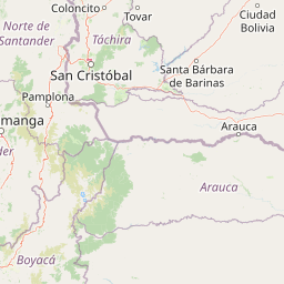
Map view of El Tamá National Park

Use this park location map to pinpoint El Tamá National Park in Venezuela, understand its exact geographic position, and read its mapped placement within the surrounding landscape more clearly.

Pigeon | © OpenStreetMap contributors

Location context for El Tamá National Park

Apure StateTáchira State
Park atlas

Browse protected landscapes across the Venezuelan Andes, comparing unique páramo ecosystems and mountain terrain near El Tamá National Park.

Discover Other National Parks and Protected Areas Near El Tamá, Exploring Adjacent Andean Landscapes
After exploring El Tamá National Park, continue your geographic discovery by browsing national parks and protected areas situated within the broader Andean mountain range. Compare varied páramo ecosystems, cloud forests, and critical watershed landscapes across Venezuela, tracing ecological connections and regional park distribution.
National parkTáchira State

Chorro El Indio National Park: Protected National Park in Táchira State's Geography

Explore mapped boundaries and regional landscape context.

Chorro El Indio National Park serves as a key protected landscape within Táchira State, Venezuela. This national park offers users detailed insights into its specific geographic setting, mapped park boundaries, and the natural terrain it encompasses. Understanding Chorro El Indio National Park through the MoriAtlas platform provides a foundation for exploring regional protected areas and their ecological significance.

Area
170 km²
Established
1989
IUCN
II
Relief
Mountain
National parkNorte de Santander

Tamá National Natural Park: Colombia's Protected Landscape and Regional Geography

Explore mapped natural features and protected area context.

Delve into the protected landscape of Tamá National Natural Park, a key national park situated in Colombia's Norte de Santander region. This resource provides an atlas-style overview of the park's geographic setting, emphasizing its mapped boundaries and its role within the broader regional geography. Understand the inherent natural context and protected status of this significant Colombian conservation area through detailed landscape information.

Area
480 km²
Established
1977
IUCN
II
Relief
Mountain
National parkBarinas

Tapo-Caparo National Park: Mapped Boundaries and Geographic Context in Barinas, Venezuela

Explore Venezuela's Tapo-Caparo National Park's protected terrain.

Tapo-Caparo National Park is a vital protected area located in the Barinas region of Venezuela. This page offers an atlas-focused exploration of its mapped natural landscape and geographic significance within the country. Understand the protected boundaries and the specific terrain features that define Tapo-Caparo National Park, providing essential context for regional geography and protected land discovery.

Area
2,050 km²
Established
1992
IUCN
II
Relief
Mountain
Natural monumentColombia

Los Estoraques Unique Natural Area: Colombian Natural Monument of Eroded Pillars

Geographic Context and Landscape Atlas

Los Estoraques Unique Natural Area stands as a distinctive protected landscape within Colombia's Norte de Santander Department. This natural monument is renowned for its striking geological formations of eroded brownstone columns and pedestals, a unique erosional terrain set within the Andean foothills. The area's mapped boundaries encompass a complex ecosystem, bridging dry forest and cloud forest zones, offering significant value for understanding regional geography and the distribution of protected lands in South America.

Area
562 km²
Established
1988
IUCN
III
Relief
Mountain
National parkSantander Department

Yariguíes National Park: National Park Geography and Protected Land Atlas

Explore mapped boundaries and regional landscape context.

Yariguíes National Park stands as a crucial protected area within the Santander Department, offering a distinct landscape for geographic study. As a designated national park, it provides vital context for understanding Colombia's protected lands and their regional distribution. This detailed view allows for in-depth exploration of its mapped terrain and natural geography, suitable for atlas-oriented discovery.

Area
788.37 km²
Established
2005
IUCN
II
Scope
Terrestrial
National parkVenezuela

Sierra La Culata National Park: Protected Landscape Atlas of the Venezuelan Andes

Explore the páramo ecosystems and mapped terrain of this Venezuelan national park.

Sierra La Culata National Park offers a profound look into the unique geography of the Venezuelan Andes. This protected national park is characterized by its expansive páramo ecosystems, dramatic mountain peaks, and glacial lagoons, creating a distinctive high-altitude wilderness. Use this atlas-focused entry to understand the park's mapped boundaries and its significant role within the region's natural landscape context.

Area
2,004 km²
Established
1989
IUCN
II
Relief
Mountain
Watercolor painting showing green hills, a river, and distant mountains under a light sky
National parkVenezuela

Sierra Nevada National Park: Venezuela's Majestic Alpine Protected Landscape and Park Boundaries

Explore the highest peaks and glacial terrain of this Venezuelan national park.

Delve into Sierra Nevada National Park, a premier protected area situated in the high Venezuelan Andes. This national park protects a vast expanse of dramatic alpine terrain, including Pico Bolívar and numerous glacial valleys. Understand its mapped boundaries and the unique paramo and cloud forest ecosystems that define this significant natural landscape within Venezuela, offering rich context for atlas-style geographic discovery.

Area
2,764.46 km²
Established
1952
IUCN
II
Relief
Mountain
National parkVenezuela

Sierra de Perijá National Park: Protected Area in Venezuela's Geographic Atlas

Explore its national park boundaries and regional landscape context.

Sierra de Perijá National Park is a designated national park in Venezuela, representing a significant protected landscape within the country. This entry facilitates detailed atlas exploration, allowing users to understand the park's precise geographic scope, its mapped boundaries, and its connection to the surrounding regional geography. Discover the core identity of this protected area and its value for geographic study and mapped landscape analysis.

Area
2,952.88 km²
Established
1978
IUCN
II
Relief
Mountain

Common questions about visiting, size, designation, and location context for El Tamá National Park

El Tamá National Park FAQs for park facts, access, geography, and protected area context
Find quick answers about El Tamá National Park, including protected-area facts, park geography, trail and visitor context, and how the park fits into its surrounding country and regional landscape.
MoriAtlas Explorer

Continue Your Protected Areas Search Across the Global Atlas

Deepen your exploration by continuing the structured search for national parks and protected areas worldwide. Utilize the comprehensive filtering capabilities to compare different conservation landscapes and refine your understanding of global park geography. Discover more about the distribution and characteristics of protected natural areas.

Global natural geography