Mori Atlas logo
National parkSierra de Perijá National Park

Trace the distinct park boundaries and understand the regional geographic context of this national park.

Sierra de Perijá National Park: Venezuela's Protected Landscape and Mapped Geography

(Parque Nacional Sierra de Perijá)

Sierra de Perijá National Park stands as a protected natural area within Venezuela, offering a crucial point for geographic discovery and atlas exploration. This national park is defined by its mapped boundaries and its significant role in the regional landscape, providing a unique lens through which to understand Venezuela's diverse protected lands. Engage with its geographic identity and explore its place within the broader atlas of natural conservation areas.

tropical rainforestcloud forestmountain ecosystemsborder parksspectacled bearendemic species

Sierra de Perijá National Park

National park

Park overview

Structured park overview, official facts, and landscape profile for Sierra de Perijá National Park

Sierra de Perijá National Park park facts, protected area profile, and essential visitor context

Review the core facts for Sierra de Perijá National Park, including designation, size, terrain, visitor scale, habitats, and operating context in one park-focused overview.

About Sierra de Perijá National Park

Sierra de Perijá National Park represents one of Venezuela's most significant protected areas, established to safeguard the exceptional biodiversity of the Serranía de Perijá, a mountain range that forms a natural barrier between Venezuela and Colombia in the far western part of the country. The park occupies a strategic position southwest of Lake Maracaibo, the large brackish lake that dominates the landscape of Zulia State and connects to the Gulf of Venezuela. This mountainous region rises sharply from the lake basin, creating a dramatic backdrop of steep forested slopes, ridgelines, and cloud-shrouded peaks. The establishment of the park in 1978 reflected growing recognition that these montane forests contained biological resources of international importance, with species found nowhere else on Earth. The park's large footprint of nearly 295,000 hectares provides substantial habitat for wildlife populations and maintains ecological connectivity across elevational gradients that would otherwise be fragmented by human development. Despite its protected status, the park faces ongoing challenges from deforestation and uncontrolled fires that threaten the integrity of its forest ecosystems.

Quick facts and research context for Sierra de Perijá National Park

Sierra de Perijá National Park lies in the Perijá and Colón municipalities of Zulia State in western Venezuela, accessible by road from the city of Maracaibo. The park occupies portions of the Serranía de Perijá, a mountain range that separates the Lake Maracaibo basin from the Colombian lowlands. The highest peak within the park is Pico Tétar at 3,500 meters above sea level. The protected area was formally established in 1978 under the management of Venezuela's National Park Institute (INPARQUES). The park's territory spans approximately 295,288 hectares of mountainous terrain.

Protection and recognition

Analyzing the official terrestrial protection boundaries and conservation status of the reserve

Sierra de Perijá National Park Protection Status and Official Designation

Exploration of Sierra de Perijá National Park requires a clear understanding of its documented terrestrial protection scope and official environmental designation history. Gathering verified conservation data provides baseline insight into how the wilderness area fits into regional protection frameworks and global geographical datasets.

Protection details

Protection scope
Terrestrial
Park context

Deeper park guide and search-rich context for Sierra de Perijá National Park

Sierra de Perijá National Park history, landscape, wildlife, and travel context

Explore Sierra de Perijá National Park through its history, landscape character, ecosystems, wildlife, conservation priorities, cultural context, and seasonal travel timing in a structured park guide built for atlas discovery and search intent.

Why Sierra de Perijá National Park stands out

Sierra de Perijá National Park is best known for its extraordinary ecological diversity spanning multiple life zones within a single protected area. The park protects one of the few remaining habitats of the spectacled bear, the only bear species native to South America, along with populations of puma, ocelot, and jaguar. The mountains harbor significant endemic bird species including the endangered Perijá metaltail hummingbird and the Perijá tapaculo, a bird species only formally described in 2015. The park's altitudinal range supports a complex mosaic of tropical rainforests, cloud forests, highland moorlands, and alpine tundra ecosystems, making it a living laboratory of Neotropical ecology.

Sierra de Perijá National Park history and protected-area timeline

Sierra de Perijá National Park was established in 1978 through Venezuelan national legislation aimed at protecting the biodiversity and scenic values of the Serranía de Perijá mountain range. The creation of the park reflected a broader movement in Venezuela during the 1970s to expand the country's protected area network and preserve representative samples of major ecological systems. The Instituto Nacional de Parques (INPARQUES) was designated as the governing body responsible for managing the park and enforcing its protected status. The park's establishment came at a time when scientific understanding of the region's remarkable biodiversity was growing, with researchers increasingly recognizing the mountains of the Serranía de Perijá as a distinct biogeographic region with numerous endemic species. Over the decades since its creation, the park has remained an important conservation priority, though management challenges related to enforcement and sustainable development in the surrounding region have persisted.

Sierra de Perijá National Park landscape and geographic character

The landscape of Sierra de Perijá National Park is dominated by the rugged terrain of the Serranía de Perijá, a mountain range that rises sharply from the southwestern margin of Lake Maracaibo. The terrain is characterized by steep slopes, deep valleys, and prominent ridges that reflect the geological complexity of this border region. Pico Tétar, the highest point within the park, reaches an elevation of 3,500 meters and is typically shrouded in mist and cloud for much of the year. The mountain range acts as a barrier separating the humid lowlands around Lake Maracaibo from the more seasonal environments of Colombia to the west. Rivers cascading down the slopes have carved V-shaped valleys and waterfalls that add to the scenic diversity of the park. The transition from the lake's shoreline up through foothills and into the high mountains creates a visually dramatic landscape that changes dramatically with elevation.

Sierra de Perijá National Park ecosystems, habitats, and plant life

The ecological complexity of Sierra de Perijá National Park stems from its extraordinary altitudinal range, which encompasses multiple distinct life zones within a relatively compact area. At lower elevations, the park protects extensive tropical rainforests dominated by towering trees such as Anacardium excelsum, Cecropia species, and various Tabebuia varieties. As elevation increases, the forest transitions into cloud forest, where persistent mist and high humidity support epiphytic plants including aroids, bromeliads, ferns, and mosses. The wax palms of the genus Ceroxylon are characteristic of these cloud forest zones. At the highest elevations, the vegetation gives way to highland moors and alpine tundra, where shorter vegetation and specialized plant species adapted to cooler, windier conditions prevail. The park also supports aquatic environments in its rivers and streams, with species such as Echinodorus present in wetland areas.

Sierra de Perijá National Park wildlife and species highlights

The wildlife community of Sierra de Perijá National Park is remarkably diverse, reflecting the park's multiple habitats and its position as a biogeographic crossroads. The park is one of the few places in Venezuela where the spectacled bear, South America's only native bear species, can be found, though populations are small and encounters are rare. Large felids including puma, ocelot, and potentially jaguar roam the forested slopes, preying on deer species such as the Amazonian brown brocket, common red brocket, and little red brocket. Collared peccaries and various primate species including Colombian red howler monkeys, grey-handed night monkeys, varied capuchins, and brown spider monkeys add to the mammalian diversity. The bird fauna is particularly noteworthy, with the endangered military macaw among the parrot species present, and the Perijá metaltail representing a hummingbird endemic to the region. The discovery and formal description of the Perijá tapaculo in 2015 highlights the continued potential for new species discoveries in this biogeographically complex area.

Sierra de Perijá National Park conservation status and protection priorities

Sierra de Perijá National Park was created specifically to protect the exceptional biodiversity of the Serranía de Perijá, recognizing the region's significance as a center of endemism and a critical habitat for rare species. The park's designation as an IUCN Category II protected area reflects its primary purpose of preserving natural ecosystems while allowing for sustainable visitor use where appropriate. The protection of the spectacled bear, an endangered species with limited distribution in Venezuela, represents a particular conservation priority given the species' vulnerability and the relatively small extent of suitable habitat in the country. Similarly, the presence of endemic bird species such as the Perijá metaltail and Perijá tapaculo underscores the park's importance for preserving populations that occur nowhere else. However, the park faces significant conservation challenges from deforestation and uncontrolled fires that continue to degrade forest ecosystems and fragment wildlife habitats.

Sierra de Perijá National Park cultural meaning and human context

The Sierra de Perijá region has historical significance as a borderland between Venezuelan and Colombian territories, though the park itself does not contain major cultural heritage sites or extensive indigenous communities. The mountain range has long served as a natural boundary, and the surrounding municipalities have mixed populations influenced by both Venezuelan and Colombian cultural traditions. The park's establishment in 1978 reflected modern conservation priorities rather than traditional land management practices, and the protected area encompasses territory that was previously used for agriculture and ranching.

Top sights and standout views in Sierra de Perijá National Park

Sierra de Perijá National Park offers visitors access to one of Venezuela's most biologically diverse mountain environments, with ecosystems ranging from tropical rainforest to alpine tundra within a single protected area. The chance to observe the spectacled bear, South America's only bear species, represents a unique wildlife viewing opportunity that draws conservation-focused visitors to the region. The park's birdlife is exceptional, with endemic species like the Perijá metaltail and the recently described Perijá tapaculo offering exceptional birdwatching potential. The dramatic scenery of the Serranía de Perijá, with its cloud-shrouded peaks and steep forested slopes rising above Lake Maracaibo, provides a striking backdrop for trekking and nature photography.

Best time to visit Sierra de Perijá National Park

The best time to visit Sierra de Perijá National Park typically falls during the dry season, which generally runs from December through April, when precipitation is lower and trail conditions are more favorable for hiking and wildlife observation. During this period, clearer skies and reduced cloud cover in the lower elevations can improve visibility of the mountain landscapes. The wet season from May through November brings higher rainfall, particularly to the lower elevations and cloud forest zones, though this period also sees more frequent mist and fog in the higher areas. The park's higher elevations can be cool year-round due to the tropical alpine environment, and visitors should be prepared for variable weather conditions regardless of the season.

Monthly climate preview

Analyzing long-term temperature ranges and precipitation rhythms across the Venezuelan park terrain

Climate Normals and Monthly Weather Averages for Sierra de Perijá National Park

Long term averages at the representative elevation of 572 meters show consistent warmth with mean temperatures between 24.4 and 27 degrees Celsius alongside fluctuating rainfall. Accessing the full monthly profile reveals detailed minimum and maximum temperature spreads plus daily precipitation averages throughout the year.
Annual mean26 °C
24 °C27 °C
Jan25°
Feb26°
Mar27°
Apr27°
May26°
Jun26°
Jul27°
Aug27°
Sep26°
Oct25°
Nov24°
Dec25°
Warmest month
August

26.9 °C

Coolest month
November

24.4 °C

Wettest month
October

4.2 mm/day

Driest month
January

0.6 mm/day

Park location guide

Geography guide, regional context, and park location map for Sierra de Perijá National Park

Sierra de Perijá National Park park geography, regions, and map view in Venezuela

Understand where Sierra de Perijá National Park sits in Venezuela through a broader geographic reading of the surrounding landscape, nearby location context, and its mapped position within the national park landscape.

How Sierra de Perijá National Park fits into Venezuela

Venezuela is a country in northern South America with coastline along the Caribbean Sea and Atlantic Ocean. It borders Colombia, Brazil, Guyana, and Trinidad and Tobago. The country has an area of approximately 916,445 km² and a population of about 31.8 million. Caracas is the capital and largest city. Venezuela consists of 23 states and the Capital District.

Wider geography shaping Sierra de Perijá National Park in Venezuela

Venezuela is located on the northern coast of South America. The continental territory is bordered by the Caribbean Sea and Atlantic Ocean to the north, Colombia to the west, Brazil to the south, and Guyana to the east. Trinidad and Tobago lies to the northeast. The country includes various islands and islets in the Caribbean Sea known as the Federal Dependencies.

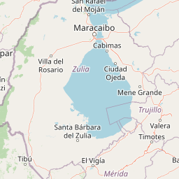
Map view of Sierra de Perijá National Park

Use this park location map to pinpoint Sierra de Perijá National Park in Venezuela, understand its exact geographic position, and read its mapped placement within the surrounding landscape more clearly.

Pigeon | © OpenStreetMap contributors

Location context for Sierra de Perijá National Park

Zulia
Park atlas

Discover adjacent mountain parks and regional conservation landscapes for comprehensive geographic comparison.

Explore Other Protected Areas Near Sierra de Perijá National Park

Continue your exploration beyond Sierra de Perijá National Park by browsing other protected areas within its surrounding mountain ranges and diverse Neotropical ecosystems. Compare park geography, conservation priorities, and the spread of critical habitats across this ecologically rich border region of Venezuela and Colombia.
National parkZulia
About 75 km away#1 closest

East

Parque Nacional Ciénagas del Catatumbo: Wetland Protected Area and Regional Geography

Expansive marshland terrain in the Zulia state of Venezuela

Parque Nacional Ciénagas del Catatumbo represents an extensive, flat mosaic of freshwater marshes, herbaceous grasslands, and gallery forests along the Catatumbo River delta. As a primary protected area in Zulia, it offers critical insights into lowland wetland ecosystems and the dynamic transition zones bordering Lake Maracaibo.

Area
2,694 km²
Established
1991
IUCN
II
Relief
Lowland
National parkVenezuela
About 75 km away#2 closest

East

Ciénagas del Catatumbo National Park: Venezuela's Freshwater Marsh Protected Landscape

Mapped wetland geography and diverse tropical savanna ecosystems.

Ciénagas del Catatumbo National Park is a vital protected area safeguarding extensive marshland and savanna ecosystems in northwestern Venezuela, specifically within the Lake Maracaibo basin. This national park is recognized for its significant freshwater marsh complex, which supports a rich diversity of bird species and plays a crucial role in the watershed's ecological health. Exploring this park offers a focused discovery of tropical wetland geography and protected landscape features.

IUCN
II
Water
Major water bodies
Natural monumentColombia
About 145 km away#3 closest

South

Los Estoraques Unique Natural Area: Colombian Natural Monument of Eroded Pillars

Geographic Context and Landscape Atlas

Los Estoraques Unique Natural Area stands as a distinctive protected landscape within Colombia's Norte de Santander Department. This natural monument is renowned for its striking geological formations of eroded brownstone columns and pedestals, a unique erosional terrain set within the Andean foothills. The area's mapped boundaries encompass a complex ecosystem, bridging dry forest and cloud forest zones, offering significant value for understanding regional geography and the distribution of protected lands in South America.

Area
562 km²
Established
1988
IUCN
III
Relief
Mountain
Watercolor painting showing mountain range with green forests and colorful landforms
National parkColombia
About 167 km away#4 closest

Northwest

Sierra Nevada de Santa Marta National Park: Colombia's Iconic Coastal Mountain Geography

Witness dramatic elevation changes and unique protected ecosystems.

Sierra Nevada de Santa Marta National Park is a distinctive protected landscape located in northern Colombia. This isolated mountain range, a UNESCO Biosphere Reserve, features an unparalleled elevational gradient from sea level to nearly 5,700 meters. The park's geography encompasses a stunning diversity of ecosystems, including tropical dry forests, Andean cloud forests, unique páramo habitats, and glacial peaks, making it a vital area for atlas-based geographic discovery and conservation.

Area
3,830 km²
Established
1964
IUCN
II
Relief
Mountain
Natural monumentMérida
About 192 km away#5 closest

Southeast

Monumento natural Meseta la Galera: Protected Andean Plateau and Geography Map

Analyzing the fluvial terrain and forest landscape of Tovar, Merida.

Monumento natural Meseta la Galera serves as a vital geographic landmark near Tovar, Merida. This protected natural monument preserves a rare flat topped plateau rising over the Mocoties River valley. Examine the structured map context of this 95 hectare forest refuge and its defined topographical boundaries within the Andean mountain foothills.

Area
0.95 km²
Established
1992
IUCN
III
Relief
Highland
National parkVenezuela
About 193 km away#6 closest

East

Sierra La Culata National Park: Protected Landscape Atlas of the Venezuelan Andes

Explore the páramo ecosystems and mapped terrain of this Venezuelan national park.

Sierra La Culata National Park offers a profound look into the unique geography of the Venezuelan Andes. This protected national park is characterized by its expansive páramo ecosystems, dramatic mountain peaks, and glacial lagoons, creating a distinctive high-altitude wilderness. Use this atlas-focused entry to understand the park's mapped boundaries and its significant role within the region's natural landscape context.

Area
2,004 km²
Established
1989
IUCN
II
Relief
Mountain
National parkMérida
About 207 km away#7 closest

Southeast

Parque nacional General Juan Pablo Peñaloza: Andean Paramo and Highland Geography Atlas

Protected mountainous terrain and glacial water networks

Spanning elevations from 1,800 meters to the 3,942-meter summit of Pico El Púlpito, this national park preserves an expansive mosaic of paramo and montane forest. The terrain features over 130 periglacial lakes, including Laguna Blanca and Laguna Grande, which sustain regional river systems and support unique species like the Andean bear and mountain tapir.

Area
752 km²
Established
1989
IUCN
II
Relief
Mountain
National parkVenezuela
About 207 km away#8 closest

Southeast

General Juan Pablo Peñaloza National Park: Venezuela National Park Atlas Entry

Mapped boundaries and regional geographic context for a protected natural area.

Explore General Juan Pablo Peñaloza National Park, a key protected area designated as a national park in Venezuela. This detailed entry focuses on its landscape identity, mapped boundaries, and its contribution to Venezuela's broader regional geography. Understand the park's significance as a protected natural area and its atlas context for in-depth geographic study.

Area
752 km²
Established
1989
Relief
Mountain
Climate
Alpine

Common questions about visiting, size, designation, and location context for Sierra de Perijá National Park

Sierra de Perijá National Park FAQs for park facts, access, geography, and protected area context

Find quick answers about Sierra de Perijá National Park, including protected-area facts, park geography, trail and visitor context, and how the park fits into its surrounding country and regional landscape.
MoriAtlas Explorer

Continue Your Protected Areas Search Across the Global Atlas

Deepen your exploration by continuing the structured search for national parks and protected areas worldwide. Utilize the comprehensive filtering capabilities to compare different conservation landscapes and refine your understanding of global park geography. Discover more about the distribution and characteristics of protected natural areas.

Global natural geography