Mori Atlas logo
National parkCiénagas del Catatumbo National Park

Discover the mapped boundaries and unique ecosystems of this Venezuelan national park.

Ciénagas del Catatumbo National Park: Protected Wetland Landscape and Geography in Venezuela

(Parque Nacional Ciénagas del Catatumbo)

Ciénagas del Catatumbo National Park represents a significant protected wetland area within Venezuela's northwestern region, nestled in the Lake Maracaibo basin. This national park encompasses extensive marshlands and savanna ecosystems, forming a vital freshwater marsh complex critical for regional biodiversity, especially for bird populations. Understanding the mapped geography and the unique character of these tropical wetlands provides essential context for exploring protected landscapes in South America.

wetlandsnational parktropical savannabird habitatLake Maracaibo basinfreshwater marsh

Ciénagas del Catatumbo National Park

National park

Park overview

Structured park overview, official facts, and landscape profile for Ciénagas del Catatumbo National Park

Ciénagas del Catatumbo National Park park facts, protected area profile, and essential visitor context

Review the core facts for Ciénagas del Catatumbo National Park, including designation, size, terrain, visitor scale, habitats, and operating context in one park-focused overview.

About Ciénagas del Catatumbo National Park

Ciénagas del Catatumbo National Park protects a substantial wetland area in northwestern Venezuela's Zulia state, within the Catatumbo region that extends across the border into Colombia. The park's landscape is dominated by freshwater marshes, seasonally flooded savannas, and scattered tree cover that characterizes the low-lying areas surrounding Lake Maracaibo. This tropical wetland system is fed by regional rainfall patterns and the hydrology of the Catatumbo basin, creating a dynamic environment where water levels fluctuate seasonally and support diverse ecological communities. The protected area represents an important conservation zone within Venezuela's network of national parks, targeting the preservation of the region's distinctive wetland habitats and the species that depend on them.

Quick facts and research context for Ciénagas del Catatumbo National Park

Ciénagas del Catatumbo National Park is located in Zulia state, northwestern Venezuela, within the Lake Maracaibo basin. The park protects a vast expanse of tropical wetlands and seasonally flooded savannas that form part of the Catatumbo region's distinctive landscape. This low-lying area receives significant rainfall and is characterized by extensive marshes, grasslands, and scattered forest patches. The wetlands serve as important habitat for waterfowl, wading birds, and other wildlife species adapted to the seasonal flooding patterns of this tropical marsh system.

Park context

Deeper park guide and search-rich context for Ciénagas del Catatumbo National Park

Ciénagas del Catatumbo National Park history, landscape, wildlife, and travel context

Explore Ciénagas del Catatumbo National Park through its history, landscape character, ecosystems, wildlife, conservation priorities, cultural context, and seasonal travel timing in a structured park guide built for atlas discovery and search intent.

Why Ciénagas del Catatumbo National Park stands out

The park is best known for its extensive wetland ecosystems within the Catatumbo region. The protected area encompasses one of Venezuela's significant freshwater marsh complexes, characterized by seasonally flooded grasslands, permanent wetlands, and adjacent savanna landscapes. These wetlands support notable bird populations and represent an important ecological component of the Lake Maracaibo watershed.

Ciénagas del Catatumbo National Park landscape and geographic character

The landscape of Ciénagas del Catatumbo National Park consists of flat to gently rolling terrain typical of the Lake Maracaibo lowlands. The area features extensive marshlands that form the heart of the protected area, interspersed with seasonally flooded grasslands and pockets of forest that provide structural diversity within the wetland matrix. The Catatumbo region's geology and hydrology create conditions favorable for wetland formation, with the area receiving abundant tropical rainfall that sustains the marsh ecosystems throughout much of the year. The landscape supports a mosaic of wetland types, from permanent open water areas to seasonally saturated grasslands.

Ciénagas del Catatumbo National Park ecosystems, habitats, and plant life

The nature of Ciénagas del Catatumbo centers on its extensive wetland ecosystems within a tropical setting. The marsh systems support vegetation adapted to periodic flooding, including emergent aquatic plants, grasses, and wetland shrubs. The surrounding savanna areas add ecological diversity to the park's habitat mosaic. These wetlands function as natural water filters and flood storage areas within the larger Lake Maracaibo watershed, providing ecological services that extend beyond the park's boundaries. The seasonal patterns of flooding create dynamic habitat conditions that support different wildlife communities throughout the year.

Ciénagas del Catatumbo National Park wildlife and species highlights

The wetlands of Ciénagas del Catatumbo provide important habitat for bird species, particularly waterfowl and wading birds that utilize the marsh environments for feeding and nesting. The seasonal flooding patterns create productive conditions for fish and other aquatic organisms, which in turn support bird populations and other wildlife. The savanna edges and forest patches within the park add structural diversity that benefits additional species groups adapted to more terrestrial conditions.

Ciénagas del Catatumbo National Park conservation status and protection priorities

Ciénagas del Catatumbo National Park was established to protect one of Venezuela's significant wetland areas within the Catatumbo region. The protected area addresses the conservation need for preserving the freshwater marsh ecosystems that face pressures from agricultural expansion and regional development. Maintaining the wetland system's integrity is important for biodiversity conservation and for sustaining the ecological functions these wetlands provide to the broader watershed.

Ciénagas del Catatumbo National Park cultural meaning and human context

The Catatumbo region has historically been a rural area with communities engaged in traditional land uses including cattle ranching and agriculture. The wetlands have been part of the regional landscape that local communities interact with, though the protected area status restricts certain activities within its boundaries. The area's proximity to the Colombia-Venezuela border gives the region a cross-border character within the broader Catatumbo basin.

Top sights and standout views in Ciénagas del Catatumbo National Park

The park's defining feature is its extensive wetland system, one of the most significant in Venezuela. The marshlands within the Catatumbo region provide critical habitat for biodiversity and represent an important ecological component of the Lake Maracaibo basin. The protected area offers a glimpse into the tropical wetland ecosystems that characterize this corner of northwestern Venezuela.

Best time to visit Ciénagas del Catatumbo National Park

The best time to explore the wetland areas of Ciénagas del Catatumbo corresponds to the dry season when lower water levels expose more ground and facilitate wildlife viewing. The wet season brings extensive flooding that transforms the landscape and may limit access to some areas. Visitors interested in observing birdlife and experiencing the wetland ecosystem at different water levels should consider timing their visit according to seasonal hydrological patterns.

Monthly climate preview

Long term representative coordinate measurements showing annual weather by month

Ciénagas del Catatumbo National Park Climate Normals, Temperature, and Precipitation

Representative coordinate records show measured monthly temperature ranges between 27.59 degrees Celsius and 30.37 degrees Celsius alongside varying precipitation averages. Opening the complete twelve month profile provides deeper insight into long term climate normals across the protected area.
Annual mean29 °C
28 °C30 °C
Jan28°
Feb29°
Mar30°
Apr30°
May30°
Jun30°
Jul30°
Aug30°
Sep29°
Oct28°
Nov28°
Dec28°
Warmest month
August

30.4 °C

Coolest month
November

27.6 °C

Wettest month
October

4.3 mm/day

Driest month
January

0.8 mm/day

Park location guide

Geography guide, regional context, and park location map for Ciénagas del Catatumbo National Park

Ciénagas del Catatumbo National Park park geography, regions, and map view in Venezuela

Understand where Ciénagas del Catatumbo National Park sits in Venezuela through a broader geographic reading of the surrounding landscape, nearby location context, and its mapped position within the national park landscape.

How Ciénagas del Catatumbo National Park fits into Venezuela

Venezuela is a country in northern South America with coastline along the Caribbean Sea and Atlantic Ocean. It borders Colombia, Brazil, Guyana, and Trinidad and Tobago. The country has an area of approximately 916,445 km² and a population of about 31.8 million. Caracas is the capital and largest city. Venezuela consists of 23 states and the Capital District.

Wider geography shaping Ciénagas del Catatumbo National Park in Venezuela

Venezuela is located on the northern coast of South America. The continental territory is bordered by the Caribbean Sea and Atlantic Ocean to the north, Colombia to the west, Brazil to the south, and Guyana to the east. Trinidad and Tobago lies to the northeast. The country includes various islands and islets in the Caribbean Sea known as the Federal Dependencies.

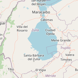
Map view of Ciénagas del Catatumbo National Park

Use this park location map to pinpoint Ciénagas del Catatumbo National Park in Venezuela, understand its exact geographic position, and read its mapped placement within the surrounding landscape more clearly.

Pigeon | © OpenStreetMap contributors
Park atlas

Understand the regional spread of protected areas surrounding the Catatumbo wetlands and Lake Maracaibo basin

Compare National Parks and Protected Areas Adjacent to Ciénagas del Catatumbo National Park

Explore additional national parks and protected areas located near Ciénagas del Catatumbo National Park, tracing the broader network of wetland and savanna ecosystems across northwestern Venezuela. This focused regional overview facilitates comparing distinct protected landscapes, understanding varied conservation priorities, and mapping the ecological connections within the Lake Maracaibo basin.
National parkZulia
About 0.7 km away#1 closest

Northwest

Parque Nacional Ciénagas del Catatumbo: Wetland Protected Area and Regional Geography

Expansive marshland terrain in the Zulia state of Venezuela

Parque Nacional Ciénagas del Catatumbo represents an extensive, flat mosaic of freshwater marshes, herbaceous grasslands, and gallery forests along the Catatumbo River delta. As a primary protected area in Zulia, it offers critical insights into lowland wetland ecosystems and the dynamic transition zones bordering Lake Maracaibo.

Area
2,694 km²
Established
1991
IUCN
II
Relief
Lowland
National parkVenezuela
About 75 km away#2 closest

West

Sierra de Perijá National Park: Protected Area in Venezuela's Geographic Atlas

Explore its national park boundaries and regional landscape context.

Sierra de Perijá National Park is a designated national park in Venezuela, representing a significant protected landscape within the country. This entry facilitates detailed atlas exploration, allowing users to understand the park's precise geographic scope, its mapped boundaries, and its connection to the surrounding regional geography. Discover the core identity of this protected area and its value for geographic study and mapped landscape analysis.

Area
2,952.88 km²
Established
1978
IUCN
II
Relief
Mountain
National parkVenezuela
About 129 km away#3 closest

Southeast

Sierra La Culata National Park: Protected Landscape Atlas of the Venezuelan Andes

Explore the páramo ecosystems and mapped terrain of this Venezuelan national park.

Sierra La Culata National Park offers a profound look into the unique geography of the Venezuelan Andes. This protected national park is characterized by its expansive páramo ecosystems, dramatic mountain peaks, and glacial lagoons, creating a distinctive high-altitude wilderness. Use this atlas-focused entry to understand the park's mapped boundaries and its significant role within the region's natural landscape context.

Area
2,004 km²
Established
1989
IUCN
II
Relief
Mountain
Natural monumentMérida
About 141 km away#4 closest

Southeast

Monumento natural Meseta la Galera: Protected Andean Plateau and Geography Map

Analyzing the fluvial terrain and forest landscape of Tovar, Merida.

Monumento natural Meseta la Galera serves as a vital geographic landmark near Tovar, Merida. This protected natural monument preserves a rare flat topped plateau rising over the Mocoties River valley. Examine the structured map context of this 95 hectare forest refuge and its defined topographical boundaries within the Andean mountain foothills.

Area
0.95 km²
Established
1992
IUCN
III
Relief
Highland
Natural monumentMérida
About 151 km away#5 closest

Southeast

Laguna de Urao Natural Monument: Geographic Profile and Protected Andean Landscape

Saline tectonic lake located in the Mérida region of Venezuela

Laguna de Urao is a singular protected natural feature of tectonic origin situated in the semi-arid Andean landscape of Mérida. Known for the accumulation of the urao mineral, this saline water body serves as an important geographic landmark that anchors the cultural and geological identity of the local surroundings.

Established
1979
Relief
Upland
Water
Major water bodies
Watercolor painting showing green hills, a river, and distant mountains under a light sky
National parkVenezuela
About 158 km away#6 closest

Southeast

Sierra Nevada National Park: Venezuela's Majestic Alpine Protected Landscape and Park Boundaries

Explore the highest peaks and glacial terrain of this Venezuelan national park.

Delve into Sierra Nevada National Park, a premier protected area situated in the high Venezuelan Andes. This national park protects a vast expanse of dramatic alpine terrain, including Pico Bolívar and numerous glacial valleys. Understand its mapped boundaries and the unique paramo and cloud forest ecosystems that define this significant natural landscape within Venezuela, offering rich context for atlas-style geographic discovery.

Area
2,764.46 km²
Established
1952
IUCN
II
Relief
Mountain
Natural monumentColombia
About 171 km away#7 closest

Southwest

Los Estoraques Unique Natural Area: Colombian Natural Monument of Eroded Pillars

Geographic Context and Landscape Atlas

Los Estoraques Unique Natural Area stands as a distinctive protected landscape within Colombia's Norte de Santander Department. This natural monument is renowned for its striking geological formations of eroded brownstone columns and pedestals, a unique erosional terrain set within the Andean foothills. The area's mapped boundaries encompass a complex ecosystem, bridging dry forest and cloud forest zones, offering significant value for understanding regional geography and the distribution of protected lands in South America.

Area
562 km²
Established
1988
IUCN
III
Relief
Mountain
National parkMérida
About 174 km away#8 closest

South

Parque nacional General Juan Pablo Peñaloza: Andean Paramo and Highland Geography Atlas

Protected mountainous terrain and glacial water networks

Spanning elevations from 1,800 meters to the 3,942-meter summit of Pico El Púlpito, this national park preserves an expansive mosaic of paramo and montane forest. The terrain features over 130 periglacial lakes, including Laguna Blanca and Laguna Grande, which sustain regional river systems and support unique species like the Andean bear and mountain tapir.

Area
752 km²
Established
1989
IUCN
II
Relief
Mountain

Common questions about visiting, size, designation, and location context for Ciénagas del Catatumbo National Park

Ciénagas del Catatumbo National Park FAQs for park facts, access, geography, and protected area context

Find quick answers about Ciénagas del Catatumbo National Park, including protected-area facts, park geography, trail and visitor context, and how the park fits into its surrounding country and regional landscape.
MoriAtlas Explorer

Continue Your Protected Areas Search Across the Global Atlas

Deepen your exploration by continuing the structured search for national parks and protected areas worldwide. Utilize the comprehensive filtering capabilities to compare different conservation landscapes and refine your understanding of global park geography. Discover more about the distribution and characteristics of protected natural areas.

Global natural geography