Mori Atlas logo
Protected areaCuenca Alimentadora del Distrito Nacional de Riego 004 Don Martín

Tracing the river corridors and mountain transition zones of central Coahuila, Mexico

Cuenca Alimentadora del Distrito Nacional de Riego 004 Don Martín: A Protected Watershed Landscape

Spanning over 15,000 square kilometers, Cuenca Alimentadora del Distrito Nacional de Riego 004 Don Martín serves as a critical watershed protection reserve in Coahuila, Mexico. This protected area bridges the dramatic ecological divide between the arid Chihuahuan Desert and the pine-oak forests of the Sierra Madre Oriental. Through these river-fed corridors, the landscape preserves the headwaters of the Sabinas, Alamós, and Mimbres rivers to support regional sustainability.

watershed protectionChihuahuan DesertSierra Madre Orientalriparian habitatpine-oak forestTamaulipan mezquital

Cuenca Alimentadora del Distrito Nacional de Riego 004 Don Martín

Protected area

Park overview

Structured park overview, official facts, and landscape profile for Cuenca Alimentadora del Distrito Nacional de Riego 004 Don Martín

Cuenca Alimentadora del Distrito Nacional de Riego 004 Don Martín park facts, protected area profile, and essential visitor context

Review the core facts for Cuenca Alimentadora del Distrito Nacional de Riego 004 Don Martín, including designation, size, terrain, visitor scale, habitats, and operating context in one park-focused overview.

About Cuenca Alimentadora del Distrito Nacional de Riego 004 Don Martín

Cuenca Alimentadora del Distrito Nacional de Riego 004 Don Martín is a large natural resources protection area in the Mexican state of Coahuila. Its name refers to the upstream catchment area that supplies the Don Martín National Irrigation District, one of the most significant agricultural water systems in northern Mexico. The reserve is therefore as much a piece of hydraulic infrastructure protection as it is a habitat conservation mechanism: by keeping the upper Salado watershed in a natural condition, the protected area helps secure water quantity and quality for farming communities downstream.

Geographically, the reserve sits where the vast northern plateau of Mexico begins to rise toward the Sierra Madre Oriental. The protected land covers three discrete areas that together span roughly 15,193 square kilometers. From west to east, the terrain shifts from desert plains and rolling grasslands up through increasingly rugged foothills to the pine-clad slopes of the Sierra Madre. The Salado River and its tributaries including the Sabinas, Alamós, and Mimbres carve through this landscape, creating corridors of green vegetation that contrast strongly with the surrounding arid land.

The reserve is administered by Mexico's National Commission of Natural Protected Areas and is classified as IUCN Category VI, a designation that emphasizes sustainable use of natural resources alongside conservation. This framing fits the watershed-protection logic of the area: the goal is not wholesale exclusion of human activity, but the maintenance of ecological functions, particularly the continuous flow and filtering of water through the upper catchment. Although the area is not primarily marketed as a tourism destination, its ecological diversity and large size give it considerable scientific and conservation value.

Ecologically, the protected area captures a remarkable transition between two major North American biomes. At its drier, lower elevations, the Chihuahuan Desert dominates, with characteristic shrubland and grassland plant communities adapted to sparse rainfall. As elevation increases and conditions become moister, the vegetation shifts toward Tamaulipan mezquital woodland. Higher still, the slopes of the Sierra Madre Oriental support oak and pine woodlands and forests that closely resemble the broader Sierra Madre Oriental pine-oak forest ecosystem. The rivers and their floodplains add a further layer, sustaining riparian forests and wetlands that are disproportionately important for regional biodiversity.

Quick facts and research context for Cuenca Alimentadora del Distrito Nacional de Riego 004 Don Martín

Cuenca Alimentadora del Distrito Nacional de Riego 004 Don Martín is a Mexican natural resources protection area located in central Coahuila, in the country's arid north. It covers roughly 15,194 square kilometers across three separate parcels and is administered by the National Commission of Natural Protected Areas under IUCN Category VI status.

The reserve protects the upper watershed of the Salado River along with key tributaries such as the Sabinas, Alamós, and Mimbres rivers. Its position at the eastern edge of the Chihuahuan Desert, bordering the Sierra Madre Oriental, gives it a distinctive mix of desert scrub, grassland, riparian woodland, and montane pine-oak forest. A portion of the Sabinas River within the area is recognized internationally as a Ramsar wetland site.

Protection and recognition

Review documented terrestrial protection scope and historical designation data for Cuenca Alimentadora del Distrito Nacional de Riego 004 Don Martín.

Cuenca Alimentadora del Distrito Nacional de Riego 004 Don Martín Protection Status and Designation History

Documented protection records for Cuenca Alimentadora del Distrito Nacional de Riego 004 Don Martín outline terrestrial conservation scopes established in 2002. Structured registry facts assemble verified designation details and international recognition sources for comprehensive analysis.

Protection details

Protection scope
Terrestrial
Designated year
2002
Transboundary protection
No
Park context

Deeper park guide and search-rich context for Cuenca Alimentadora del Distrito Nacional de Riego 004 Don Martín

Cuenca Alimentadora del Distrito Nacional de Riego 004 Don Martín history, landscape, wildlife, and travel context

Explore Cuenca Alimentadora del Distrito Nacional de Riego 004 Don Martín through its history, landscape character, ecosystems, wildlife, conservation priorities, cultural context, and seasonal travel timing in a structured park guide built for atlas discovery and search intent.

Why Cuenca Alimentadora del Distrito Nacional de Riego 004 Don Martín stands out

CADNR 004 Don Martín is best known as a watershed protection reserve on the eastern flank of the Sierra Madre Oriental, guarding the headwaters that supply one of northern Mexico's most important irrigation districts. The reserve captures the upper Salado River basin and several of its principal tributaries, including the Sabinas, Alamós, and Mimbres rivers, across an area spanning desert lowlands to forested mountain slopes. It is also notable for its position along one of Mexico's most pronounced ecological boundaries. The Chihuahuan Desert meets the Tamaulipan mezquital in the lower elevations, while oak and pine woodlands rise on the Sierra Madre Oriental above. This ecological stacking, combined with the protected riparian corridors along the rivers, gives the area a distinctive conservation profile in northern Mexico.

Cuenca Alimentadora del Distrito Nacional de Riego 004 Don Martín history and protected-area timeline

The protected area has its roots in mid-twentieth century Mexican water policy. On 3 August 1949, by decree of President Miguel Alemán Valdés, the upper catchment feeding the downstream irrigation system was given protected status. At that time the primary motivation was to safeguard the watershed so that the irrigated farms of the Don Martín district would continue to receive a reliable supply of water.

In the decades that followed, awareness grew of the broader ecological value of the watershed beyond its role in water supply. On 7 November 2002 the area was re-designated as a natural resources protection area, a category that explicitly combines conservation of natural values with sustainable use of resources. This change embedded the watershed within Mexico's modern system of protected natural areas, administered by the National Commission of Natural Protected Areas.

A further milestone came on 2 February 2008, when a portion of the Sabinas River within the protected area was designated a Ramsar site, recognizing it internationally as a wetland of importance. The Ramsar designation highlighted the role of the river corridor as habitat for waterbirds and other wetland-associated species, extending the significance of the area beyond Mexican water and conservation policy into global wetland conservation frameworks.

Cuenca Alimentadora del Distrito Nacional de Riego 004 Don Martín landscape and geographic character

The landscape of CADNR 004 Don Martín is shaped by the meeting of two major physical features: the wide, arid northern Mexican plateau and the eastern escarpment of the Sierra Madre Oriental. Much of the protected area lies on gently sloping plains and low hills characteristic of Coahuila's interior, where dry shrubland and grassland stretch across broad valleys. Surface water is concentrated in the river corridors, which cut visible green traces through an otherwise semi-arid terrain.

Toward the east, the land rises into the foothills and mountains of the Sierra Madre Oriental. Here elevation adds moisture and cooler temperatures, producing a more forested character. The slopes alternate between rocky outcrops, narrow canyons, and higher forested ridges. Rivers descending from the Sierra Madre, including the Sabinas, Alamós, and Mimbres, drain eastward and converge with the Salado River, whose upper catchment the reserve was created to protect.

The visual character of the area is one of stark transitions. Open desert vistas give way abruptly to wooded canyons; dry grasslands climb into pine-clad ridges; and arid flats are interrupted by ribbons of dense riparian vegetation along permanent and seasonal watercourses. This layered topography is one of the defining scenic qualities of the protected area.

Cuenca Alimentadora del Distrito Nacional de Riego 004 Don Martín ecosystems, habitats, and plant life

CADNR 004 Don Martín spans an unusually broad ecological gradient for a single protected area in northern Mexico. Its western and lower portions sit at the eastern margin of the Chihuahuan Desert, where vegetation is dominated by drought-adapted shrubs, succulents, and dry grasslands that can survive on minimal rainfall. Moving toward the south and east, the terrain transitions into the Tamaulipan mezquital, a more mesic thornscrub and small-tree woodland that bridges the desert and the sub-humid woodlands of northeastern Mexico.

Further east and at higher elevations, the reserve overlaps with the Sierra Madre Oriental pine-oak forests. On the upper slopes of the Sierra Madre, oak and pine woodlands form continuous canopies that contrast sharply with the open vegetation of the lowlands below. The combination of desert, mesquite woodland, and montane forest in one managed area gives the reserve an unusually complete representation of the ecological zonation typical of the Coahuila portion of the Sierra Madre Oriental.

Along the rivers, riparian forests and wetlands add a fourth ecological layer. These corridors support trees and shrubs that require reliable access to water, creating green corridors that sustain wildlife movement and provide nesting and feeding habitat for many species. The resulting ecological mosaic, dry desert to wet riparian to cool montane forest, is the biological signature of the protected area.

Cuenca Alimentadora del Distrito Nacional de Riego 004 Don Martín wildlife and species highlights

Wildlife in CADNR 004 Don Martín reflects the reserve's strong ecological heterogeneity. In the desert and mezquital portions of the area, characteristic arid-land mammals such as various rodents, lagomorphs, coyotes, and other mesopredators find habitat. Reptiles, including lizards and snakes adapted to dry conditions, are also well represented in the lower zones, as are the birds typical of the Chihuahuan Desert and Tamaulipan thornscrub.

The riparian corridors along the Sabinas, Alamós, Mimbres, and Salado rivers concentrate much of the area's biological activity. These wooded watercourses support a richer community of birds and small mammals, and provide important cover and movement corridors through otherwise arid terrain. The wetlands associated with the rivers, particularly along the Sabinas, are significant for migratory and resident waterbirds, which is a key reason the Sabinas portion of the area was recognized as a Ramsar site.

Higher in the Sierra Madre Oriental slopes, the oak and pine woodlands host species more typical of montane environments, including a different suite of breeding birds and small forest-dwelling mammals. The proximity of montane forest to desert lowlands in a single protected area expands the range of habitats available to wide-ranging species and enhances the overall wildlife value of the reserve.

Cuenca Alimentadora del Distrito Nacional de Riego 004 Don Martín conservation status and protection priorities

From a conservation perspective, CADNR 004 Don Martín is significant primarily as a watershed protection mechanism that delivers both ecological and human-use benefits. By safeguarding the upper catchment of the Salado River, the reserve protects the hydrological function that supports the Don Martín irrigation district and downstream agricultural communities, illustrating how watershed protection can serve as a bridge between environmental and economic objectives.

At the same time, the reserve contains ecological values that extend far beyond water supply. Its overlap with the Sierra Madre Oriental pine-oak forests, the Chihuahuan Desert, and the Tamaulipan mezquital means that the protected area conserves a representative cross-section of three major North American biomes. The transition zones between these biomes are often where biodiversity is concentrated, and the reserve's layered landscape makes it an important refuge for species that depend on more than one habitat type.

The Ramsar designation of a portion of the Sabinas River adds an international dimension to the area's conservation profile, ensuring that its wetland values are recognized within global frameworks. Together, these designations place CADNR 004 Don Martín at the intersection of watershed management, biome-level habitat conservation, and international wetland protection.

Cuenca Alimentadora del Distrito Nacional de Riego 004 Don Martín cultural meaning and human context

The cultural context of the reserve is closely tied to its role as a water source for one of northern Mexico's important agricultural regions. The Don Martín irrigation district downstream has shaped rural settlement and farming traditions in central Coahuila, and the protected area's existence reflects a long-standing recognition that productive agriculture in this arid region depends directly on the condition of the upper watershed.

There is also a broader Mexican conservation tradition reflected in the reserve. The original 1949 decree, issued under President Miguel Alemán Valdés, was part of an early effort to embed conservation in national water policy. The later re-designation as a natural resources protection area in 2002 aligned the watershed with a more ecologically grounded conservation framework, while the participation of the National Commission of Natural Protected Areas reflects the institutional evolution of conservation in Mexico during the late twentieth and early twenty-first centuries.

Top sights and standout views in Cuenca Alimentadora del Distrito Nacional de Riego 004 Don Martín

The strength of CADNR 004 Don Martín lies in the combination of its scale, its ecological diversity, and its clearly defined protective purpose. Covering roughly 15,194 square kilometers across three parcels in central Coahuila, it is among the larger protected areas in northern Mexico and offers a rare single-unit view of the transition from Chihuahuan Desert to Tamaulipan mezquital to Sierra Madre Oriental pine-oak forest.

Its protected river corridors, especially along the Sabinas, give the area outsized importance for wetland-associated wildlife and underpin its international recognition through the Ramsar site designation on the Sabinas River. The reserve's watershed protection function, formally dating to 1949 and reaffirmed in 2002, connects its ecological value directly to the long-term sustainability of the Don Martín irrigation district downstream, making it a notable example of integrated water and conservation policy.

Best time to visit Cuenca Alimentadora del Distrito Nacional de Riego 004 Don Martín

Given the strongly seasonal climate of central Coahuila, the timing of any visit affects both conditions and wildlife experience. Cooler months generally offer more comfortable temperatures across the reserve, particularly in the desert lowlands where summer heat can be intense, and they often correspond with greener vegetation along riparian corridors following late-summer rains.

The transitional seasons can also be rewarding, when temperatures are moderate and desert flora may respond to rainfall with a temporary flush of greenery and flowering. Anyone interested in waterbirds or wetland-dependent wildlife along the Sabinas and other rivers should consider periods when migratory and resident waterbirds are most active, which in northern Mexico typically aligns with the cooler months and the associated seasonal dynamics of the region's wetlands.
Monthly climate preview

Long-term temperature and precipitation patterns across representative coordinates

Cuenca Alimentadora del Distrito Nacional de Riego 004 Don Martín Climate Normals

Representative coordinate records show measured monthly temperature ranges alongside consistent precipitation averages throughout the year. Reviewing the complete monthly climate breakdown provides deeper insight into long-term thermal rhythms and moisture distributions.
Annual mean22 °C
13 °C30 °C
Jan13°
Feb16°
Mar20°
Apr24°
May27°
Jun30°
Jul30°
Aug30°
Sep27°
Oct22°
Nov17°
Dec13°
Warmest month
August

29.8 °C

Coolest month
January

12.6 °C

Wettest month
September

2.6 mm/day

Driest month
February

0.4 mm/day

Park location guide

Geography guide, regional context, and park location map for Cuenca Alimentadora del Distrito Nacional de Riego 004 Don Martín

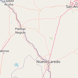
Cuenca Alimentadora del Distrito Nacional de Riego 004 Don Martín park geography, regions, and map view in Mexico

Understand where Cuenca Alimentadora del Distrito Nacional de Riego 004 Don Martín sits in Mexico through a broader geographic reading of the surrounding landscape, nearby location context, and its mapped position within the national park landscape.

How Cuenca Alimentadora del Distrito Nacional de Riego 004 Don Martín fits into Mexico

Mexico, officially the United Mexican States, is a country in North America spanning the Sierra Madre mountain ranges, coastal plains, and tropical regions. It borders the United States to the north, Guatemala and Belize to the southeast, and has coastlines along the Pacific Ocean, Gulf of Mexico, and Caribbean Sea. With a population exceeding 130 million, Mexico is home to one of the world's most significant concentrations of Indigenous languages alongside Spanish.

Wider geography shaping Cuenca Alimentadora del Distrito Nacional de Riego 004 Don Martín in Mexico

Mexico occupies a land area of 1,972,550 km2, making it the thirteenth-largest country in the world. The terrain is highly diverse, featuring the Sierra Madre Occidental and Sierra Madre Oriental mountain ranges, the Mexican Plateau, coastal lowlands along the Pacific and Gulf/Caribbean margins, and the Yucatan Peninsula. The country spans multiple climate zones from desert in the north to tropical rainforest in the south.

Map view of Cuenca Alimentadora del Distrito Nacional de Riego 004 Don Martín

Use this park location map to pinpoint Cuenca Alimentadora del Distrito Nacional de Riego 004 Don Martín in Mexico, understand its exact geographic position, and read its mapped placement within the surrounding landscape more clearly.

Pigeon | © OpenStreetMap contributors

Location context for Cuenca Alimentadora del Distrito Nacional de Riego 004 Don Martín

Coahuila
Park atlas

Compare surrounding protected areas and regional conservation landscapes

Explore Other Parks Near Cuenca Alimentadora del Distrito Nacional de Riego 004 Don Martín

Browsing nearby protected areas helps reveal the broader ecological transitions connecting desert lowlands to mountain forests across the region. Comparing adjacent watershed reserves provides deeper geographic context for understanding northern Mexico conservation lands.
Watercolor painting of a desert landscape with white gypsum dunes, a central turquoise blue pool, and yucca plants.
Wildlife reserveCoahuila
About 139 km away#1 closest

Southwest

Área de Protección de Flora y Fauna Cuatrociénegas: Protected Landscape and Atlas Map

Desert wetlands and gypsum dune geography in Coahuila, Mexico

This wildlife reserve in Coahuila represents a globally significant desert wetland complex. Featuring hundreds of spring-fed pozas and the second-largest gypsum dune field in the Americas, the reserve offers a unique look at isolated ecosystems and specialized biodiversity within the Chihuahuan Desert.

Area
843.47 km²
Established
1994
Relief
Lowland
Climate
Arid
Protected landscapeTexas
About 174 km away#2 closest

North

Amistad National Recreation Area: Mapped Protected Landscapes in Texas

Desert reservoir geography and canyon ecosystems

Amistad National Recreation Area represents a distinct protected landscape located in Val Verde County, Texas. Centered on the expansive Amistad Reservoir at the United States-Mexico border, the area features rugged limestone canyons and extensive water-based terrain where the Rio Grande, Devils, and Pecos rivers meet. The site offers deep insight into desert canyon geography and historic rock art distributions.

Area
237 km²
Established
1965
Visitors
912.3K annual
Relief
Upland
Watercolor painting of soft, layered green mountain silhouettes against a pale sky.
Wildlife reserveCoahuila
About 206 km away#3 closest

Northwest

Área de protección de flora y fauna Maderas del Carmen: Protected Desert Mountain Geography

Rugged limestone ranges and conservation corridors in northern Coahuila

The Área de protección de flora y fauna Maderas del Carmen protects an expansive, high-elevation desert mountain landscape. Featuring the Sierra del Carmen and Sierra el Jardín, the reserve bridges arid desert basins with forested upland terrain, creating one of northern Mexico's most significant ecological corridors for scientific study and wilderness preservation.

Area
2,083.81 km²
Established
1994
Relief
Mountain
Climate
Arid
Wildlife reserveCoahuila
About 209 km away#4 closest

Northwest

Ocampo Flora and Fauna Protection Area: Mapping Desert and Riverine Geography in Coahuila

A vital transboundary wildlife reserve in northern Mexico

Ocampo Flora and Fauna Protection Area provides a massive, contiguous block of protected wilderness characterized by rugged mountain foothills and desert flats. As a cornerstone of the El Carmen Big Bend Complex, the reserve offers a unique look at how river-cut canyons and arid scrublands support diverse life forms in the northern Chihuahuan Desert of Coahuila.

Area
3,442.38 km²
Established
2009
IUCN
VI
Relief
Mixed relief
National parkBrewster County
About 226 km away#5 closest

Northwest

Big Bend National Park: National Park, Mapped Protected Landscape, and Regional Geography

Explore Brewster County's protected natural terrain.

Big Bend National Park is a prominent national park defined by its protected landscape and geographic features within Brewster County. This destination provides users with detailed atlas-style information, focusing on the park's mapped boundaries and its contribution to the understanding of regional natural geography. Delve into the specific context of this protected area to enhance your geographic discovery.

Area
3,242.19 km²
Established
1944
IUCN
II
Visitors
568.1K annual
Protected areaNuevo León
About 258 km away#6 closest

Southeast

Sierra de Picachos Protected Area: Geographic Boundaries and Regional Landscapes

Mountain geography in northern Nuevo León

Sierra de Picachos represents a vital conservation zone spanning north of Monterrey. The landscape is defined by its dramatic elevation changes, moving from desert-like plains to cool coniferous slopes. This atlas entry focuses on the physical boundaries, ecological zones, and the rugged, peak-studded terrain that distinguish the range from the surrounding Sierra Madre Oriental.

Area
1,405 km²
Established
2000
Relief
Mountain
Climate
Subtropical
Watercolor illustration of layered mountain ranges with purple peaks fading into a green and yellow foreground.
Natural monumentNuevo León
About 264 km away#7 closest

South

Cerro de la Silla: Protected Natural Monument Geography and Regional Map Context

A rugged mountain landscape in Nuevo León, Mexico

Cerro de la Silla is defined by its unmistakable saddle-shaped silhouette and its status as a vital protected area within the urban matrix of Monterrey. The mountain features complex folded limestone geology and a diverse habitat mosaic that transition from arid scrubland to forested peaks. Use this atlas resource to understand its topographical boundaries, summit formations, and regional environmental significance within the Sierra Madre Oriental fold belt.

Area
60 km²
Established
1991
Relief
Mountain
Climate
Subtropical
Watercolor painting of a mountain range featuring gentle slopes and low-lying shrubs against a white background.
Protected areaCoahuila
About 281 km away#8 closest

South

Serranía de Zapalinamé: Protected Mountain Geography and Watershed in Coahuila

Ecological transition zone within the Sierra Madre Oriental

The Serranía de Zapalinamé forms a dramatic mountain corridor rising over Saltillo, Coahuila. This state natural reserve protects a vital watershed and biodiversity hotspot where Chihuahuan Desert scrub meets pine and oak montane forests. Its steep canyons and high ridges offer a significant case study in regional landscape conservation and natural water security.

Area
253.74 km²
Established
1996
Relief
Mountain
Climate
Arid

Common questions about visiting, size, designation, and location context for Cuenca Alimentadora del Distrito Nacional de Riego 004 Don Martín

Cuenca Alimentadora del Distrito Nacional de Riego 004 Don Martín FAQs for park facts, access, geography, and protected area context

Find quick answers about Cuenca Alimentadora del Distrito Nacional de Riego 004 Don Martín, including protected-area facts, park geography, trail and visitor context, and how the park fits into its surrounding country and regional landscape.
MoriAtlas Explorer

Continue Your Protected Areas Search Across the Global Atlas

Deepen your exploration by continuing the structured search for national parks and protected areas worldwide. Utilize the comprehensive filtering capabilities to compare different conservation landscapes and refine your understanding of global park geography. Discover more about the distribution and characteristics of protected natural areas.

Global natural geography