Mori Atlas logo
Protected areaSierra de Picachos

Examining the rugged canyons, pine-oak forests, and distinct peaks of this massif

Sierra de Picachos: An Atlas of Protected Mountain Landscapes in Nuevo León, Mexico

(Sierra Picachos (Área Natural Protegida estatal))

Sierra de Picachos rises as a prominent mountain range above the semi-arid plains of northern Nuevo León. This protected natural area features a striking transition from Tamaulipan matorral shrubland at its base to elevated oak and pine-oak woodlands. The massif forms a self-contained geologic landmark characterized by sharp peaks, steep canyon systems, and plateaus that serve as a crucial refuge for regional wildlife.

mountain rangesemi-arid landscapeTamaulipan matorraloak forestpine-oak woodlandprotected natural area

Sierra de Picachos

Protected area

Park overview

Structured park overview, official facts, and landscape profile for Sierra de Picachos

Sierra de Picachos park facts, protected area profile, and essential visitor context

Review the core facts for Sierra de Picachos, including designation, size, terrain, visitor scale, habitats, and operating context in one park-focused overview.

About Sierra de Picachos

Sierra de Picachos is a compact but visually dominant mountain range in Nuevo León, in northeastern Mexico. Although geographically it belongs to the Sierra Madre Oriental, the range is geologically and visually distinct, separated from the principal eastern Sierra Madre ridges by a mountain pass that carries Highway 85 between Monterrey and Nuevo Laredo. This separation gives Picachos an isolated, island-like quality on the landscape, with steep rocky summits rising abruptly from the surrounding plains.

The range covers a broad area, with elevations rising from approximately 400 m at its base to roughly 1,521 m at its highest point. Lower slopes are cloaked in Tamaulipan matorral, a semi-desert shrubland made up of woody plants, small trees, cacti, and succulents typical of the region. Above around 800 m, vegetation shifts to oak forest, with patches of Arizona pine and Mexican pine interspersed among the oaks. This altitudinal layering gives the sierra a rich mosaic of habitats within a relatively compact area, supporting wildlife that ranges from arid-adapted species to forest-dwelling mammals.

Picachos has strong ecological significance. Surveys of the area have recorded 146 bird species, marking it as an Important Bird Area and a stopover for migratory species. Mammals such as the American black bear and cougar still roam the range. Over the past two decades, the area has been progressively formalized as a Protected Natural Area by the state of Nuevo León, with the most recent expansion in 2021 making it the largest state-level protected area in the state.

The range is also a cultural and recreational landmark. Its iconic skyline is visible from the Monterrey metropolitan area and is closely tied to the identity of nearby municipalities such as Higueras, Sabinas Hidalgo, Agualeguas, and Cerralvo. Hiking, climbing, mountain biking, and birdwatching are popular activities, and the area is supported by local conservation organizations working to expand protection and manage the surrounding watershed.

Quick facts and research context for Sierra de Picachos

Sierra de Picachos lies in Nuevo León, Mexico, about 35 miles northeast of Monterrey. It is considered part of the Sierra Madre Oriental but stands as a separate massif, crossed by Highway 85 through a mountain pass to the south. The range spans approximately 55 km north to south and 25 km east to west, with a maximum elevation near 1,521 m at Pico Picachos.

The terrain is dominated by Tamaulipan matorral shrubland in the lower elevations, transitioning to oak forest and mixed pine woodland above about 800 m. The area was first declared a Protected Natural Area as Cerro Picachos in 2000 and redesignated Sierra Picachos in 2003; a major 2021 expansion made it the largest state protected area in Nuevo León. A 1997 to 2000 avian survey documented 146 bird species in the range.

Protection and recognition

Documented terrestrial protection history, management scope, and recognition records

Sierra de Picachos Protection Status and Designated Area Records

Sierra de Picachos maintains documented terrestrial protection status established in 2003 under official conservation records. Structured details outline management scope and designation history for geographic analysis.

Protection details

Protection scope
Terrestrial
Designated year
2003
Transboundary protection
No
WDPA ID
108069
Park context

Deeper park guide and search-rich context for Sierra de Picachos

Sierra de Picachos history, landscape, wildlife, and travel context

Explore Sierra de Picachos through its history, landscape character, ecosystems, wildlife, conservation priorities, cultural context, and seasonal travel timing in a structured park guide built for atlas discovery and search intent.

Why Sierra de Picachos stands out

Sierra de Picachos is best known for the rugged, rocky-topped peaks that define its skyline above the plains northeast of Monterrey. The range is also recognized for its layered vegetation, ranging from semi-desert Tamaulipan matorral at its base to oak and mixed pine-oak forest higher up, and for the strong contrast between warm arid foothills and cooler forested summits. It is additionally notable as a key bird area, with 146 recorded bird species, and as a refuge for mammals such as the American black bear and cougar. Its protected status, scenic prominence, and proximity to a major metropolitan region give it a unique role in regional conservation and outdoor recreation.
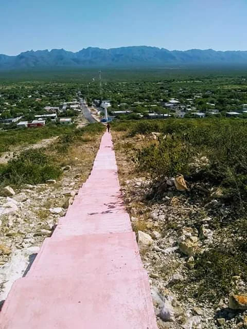
A long, wide, light-pink concrete staircase descends through a rocky, scrub-covered hillside, overlooking a small town and a distant mountain range under a clear blue sky.
A steep stairway leading down toward the town, with the Sierra de Picachos mountains visible in the distance.

Sierra de Picachos history and protected-area timeline

Sierra de Picachos has a long human history that long predates its modern conservation status. In 1577, the Spanish explorer Alberto del Canto documented silver and lead deposits at the site he called Minas de San Gregorio, naming the range Sierra de San Gregorio at the time. The area was inhabited by indigenous groups known to the Spanish as Los Borrados, whose population declined sharply due to enslavement and flight. By 1596, references in the founding records of Monterrey described the Sierra de San Gregorio in connection with local caciques and indigenous communities in the region.

Mining activity in the range continued through the 17th and 18th centuries, carried out largely by gambusinos, independent prospectors who faced ongoing difficulties due to the presence of indigenous groups in the area. Aside from mining, agriculture has played a smaller role, occupying only a modest share of the land surface, and most of the land within the protected zone remains privately owned with relatively limited human impact.

The modern conservation era began on 24 November 2000, when the Governor of Nuevo León, Fernando Canales Clariond, declared twenty-three state Protected Natural Areas in the official gazette, including Cerro Picachos. This initial declaration protected roughly 33,600 hectares centered on a pine and oak forest. On 1 October 2003, the protected area was redesigned and expanded as Sierra Picachos, covering over 75,800 hectares. On 22 September 2021, the area was expanded a second time, growing to approximately 175,305 hectares and becoming the largest state protected area in Nuevo León. Throughout this period, local organizations like the Asociación Ecológica Sierra de Picachos (AESPAC) and the IDEAS center have advocated for stronger protection and broader recognition of the range's ecological importance.

Sierra de Picachos landscape and geographic character

Sierra de Picachos is defined by the sharp visual contrast between its arid, gently sloping foothills and its rocky, peak-studded interior. The range rises abruptly from surrounding plains, with its highest summit reaching around 1,521 m and several other named peaks exceeding 1,300 m. The massif spans roughly 55 km north to south and 25 km east to west, forming a striking block-shaped presence on the horizon of northern Nuevo León.

The lower elevations are dominated by Tamaulipan matorral, a semi-desert shrubland interspersed with cacti, succulents, and small woody trees. As elevation increases, the vegetation transitions, giving way to oak forest that covers an estimated 15 percent of the total land area. Above the oak zone, isolated patches of Arizona pine and Mexican pine add further variety to the flora.

The terrain includes canyon systems, waterfalls, conical peaks, and mesetas interspersed with mixed conifer and oak woodland. Local landmarks include the Bromelia peak with its seasonally blooming bromeliads, the conical Caja Pinta, and the plateaus and rancho areas around Higueras. The pass crossed by Highway 85 separates Picachos visually and geologically from the Sierra Madre Oriental ridges to the south, reinforcing the range's identity as a compact, self-contained natural landmark.

Sierra de Picachos ecosystems, habitats, and plant life

Sierra de Picachos supports a layered ecological system that changes meaningfully with elevation over a relatively compressed geographic footprint. At the base, the Tamaulipan matorral hosts drought-adapted shrubs, succulents, cacti, and small trees, while mid-elevations transition into oak woodlands. The upper elevations support patches of oak-dominated forest mixed with stands of Arizona pine and Mexican pine, creating a vertical mosaic of habitats within the same massif.

Soil types include shallow Leptosols, which dominate large portions of the area, and deeper Calcisols, which appear in pockets elsewhere. The dominant semi-arid climate is punctuated by more humid microclimates at higher elevations, with rainfall concentrated heavily in the summer months from May through October. The combination of varied terrain, elevation, and microclimates contributes to a notable diversity of birdlife and supports both resident and migratory species.

Because of this ecological layering, the range functions as a refuge for forest-dwelling mammals and bird species that would not otherwise persist in the surrounding lowland shrubland. The vegetation also includes endemic or characteristic dryland plants, and the range supports seasonal floral displays such as bromeliad blooms that are locally celebrated through place names like Pico La Bromelia.

Sierra de Picachos wildlife and species highlights

Sierra de Picachos is home to a particularly diverse avifauna for its size. Surveys conducted from 1997 to 2000 documented 146 bird species in the range, supporting its recognition as an Important Bird Area and a refuge for migratory as well as resident birds.

Mammals of conservation interest include the American black bear and the cougar, both of which rely on the forested upper elevations of the sierra. The area also harbors less conspicuous species such as bats, including Plecotus mexicanus, and reptiles like the Mexican mud turtle and various snake species.

The combination of arid lowland habitat and forested uplands allows the range to support a wide spectrum of ecological roles, from cactus-loving desert wildlife to forest-based predators and migratory songbirds. This vertical mix of wildlife communities is a defining feature of the sierra's ecological character.

Sierra de Picachos conservation status and protection priorities

Sierra de Picachos holds significant conservation value because it preserves an unusually diverse mosaic of habitats, including Tamaulipan matorral, oak forest, and mixed pine-oak woodland, within a relatively compact area. This layering supports a wide range of plants, birds, and mammals and elevates the range's importance for regional biodiversity.

The range was first declared a state-level Protected Natural Area as Cerro Picachos in 2000, an initial designation focused on a pine-oak forest core. In 2003, it was redesigned as the Sierra Picachos Protected Natural Area with an expanded footprint, and a second major expansion in 2021 more than doubled its size, making it the largest state protected area in Nuevo León. Despite these advances, the area's protected status has co-existed with continuing pressures from extractive activities and water-use demands, and conservation groups such as AESPAC have advocated for further expansion.

A particular concern has been the impact of quarrying activity on the range, since the operation of large quarries inside the protected zone has raised concerns about damage to surrounding ecosystems and to the Agualeguas-Los Ramones hydrological basin, which the sierra feeds. These ongoing tensions between declared protection and actual land use make Picachos a key example of both state-level conservation ambition and the challenges of preserving semi-arid landscapes near major urban centers.

Sierra de Picachos cultural meaning and human context

Sierra de Picachos is deeply tied to the cultural and visual identity of northern Nuevo León. Its distinctive silhouette features in the coat of arms of the municipality of Ciénega de Flores, and its peaks serve as geographic landmarks for surrounding communities such as Higueras, Sabinas Hidalgo, Agualeguas, Cerralvo, and Marín. Place names drawn from local flora, such as Pico La Bromelia, Pico El Durazno, El Nogal, and Hierbabuena, reflect how deeply intertwined the natural environment is with everyday regional vocabulary.

The range also carries a layered human history, including the colonial-era mining activity around the Sierra de San Gregorio and the long presence of indigenous communities in the foothills, both of which underpin modern regional identity. Today, conservation organizations like AESPAC and the IDEAS center in Higueras play an important role in regional civic life, promoting environmental advocacy and linking mountain recreation to broader social and ecological concerns.

Top sights and standout views in Sierra de Picachos

Sierra de Picachos is defined visually by its rocky skyline of named peaks and by the steep transition from desert shrubland to oak and pine forest. The protected area covers a broad swath of northern Nuevo León and is the largest state-level natural protected area in the state.

Notable highlights include the range's status as an Important Bird Area, with 146 documented bird species, its role as habitat for black bears and cougars, and its proximity to Monterrey. Local adventures such as the Picachos Adventures Outdoor Fest in Higueras, along with hiking and climbing routes through canyons and pine forest, give the area a vibrant outdoor culture despite being close to a major metropolitan region.

Best time to visit Sierra de Picachos

The climate of Sierra de Picachos is predominantly semi-arid, with hot summers and cool winters that can include frosts at higher elevations. Precipitation is highly variable across the range and is concentrated in the summer months from May to October, while winters tend to be dry.

For visitors, the cooler and drier winter and early spring months generally offer the most comfortable conditions for hiking and climbing, with clearer skies and less risk of intense heat. Upper elevations retain cooler temperatures even in summer and can be more comfortable for outdoor activity than the warmer lowland towns. Spring is also a notable time because some of the range's seasonal flora, including bromeliads, bloom in the early months of the season.

Monthly climate preview

Long-term temperature and precipitation records across twelve representative months

Sierra de Picachos Climate Normals and Measured Monthly Temperature Patterns

Representative coordinates track measured annual temperature swings and monthly precipitation averages from 1991 to 2020. Examining the complete monthly climate dataset provides deeper context for the long-term weather patterns across the protected landscape.
Annual mean24 °C
15 °C30 °C
Jan15°
Feb18°
Mar22°
Apr26°
May29°
Jun30°
Jul30°
Aug30°
Sep27°
Oct24°
Nov19°
Dec15°
Warmest month
June

30.2 °C

Coolest month
January

14.8 °C

Wettest month
September

4.5 mm/day

Driest month
February

0.6 mm/day

Park location guide

Geography guide, regional context, and park location map for Sierra de Picachos

Sierra de Picachos park geography, regions, and map view in Mexico

Understand where Sierra de Picachos sits in Mexico through a broader geographic reading of the surrounding landscape, nearby location context, and its mapped position within the national park landscape.

How Sierra de Picachos fits into Mexico

Mexico, officially the United Mexican States, is a country in North America spanning the Sierra Madre mountain ranges, coastal plains, and tropical regions. It borders the United States to the north, Guatemala and Belize to the southeast, and has coastlines along the Pacific Ocean, Gulf of Mexico, and Caribbean Sea. With a population exceeding 130 million, Mexico is home to one of the world's most significant concentrations of Indigenous languages alongside Spanish.

Wider geography shaping Sierra de Picachos in Mexico

Mexico occupies a land area of 1,972,550 km2, making it the thirteenth-largest country in the world. The terrain is highly diverse, featuring the Sierra Madre Occidental and Sierra Madre Oriental mountain ranges, the Mexican Plateau, coastal lowlands along the Pacific and Gulf/Caribbean margins, and the Yucatan Peninsula. The country spans multiple climate zones from desert in the north to tropical rainforest in the south.

Map view of Sierra de Picachos

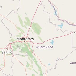
Use this park location map to pinpoint Sierra de Picachos in Mexico, understand its exact geographic position, and read its mapped placement within the surrounding landscape more clearly.

Pigeon | © OpenStreetMap contributors

Location context for Sierra de Picachos

Nuevo León

Visualizing rugged peaks, desert foothills, and forested mountain habitats

Sierra de Picachos Photos and Landscape Scenery

Examining Sierra de Picachos imagery reveals the sharp topographical shift from arid lowland shrublands to elevated oak and pine woodlands. Visual records of the protected area document its rocky skyline, canyon systems, and diverse ecological zones across northern Nuevo León.

A long, wide, light-pink concrete staircase descends through a rocky, scrub-covered hillside, overlooking a small town and a distant mountain range under a clear blue sky.

Park atlas

Compare regional mountain ranges, canyon systems, and protected habitats across northeastern Mexico

Explore Other Parks Near Sierra de Picachos and Surrounding Protected Landscapes

Continue geographic discovery by comparing adjacent protected areas and regional mountain reserves situated across northeastern Mexico. Broaden regional park exploration to examine diverse conservation terrain surrounding Sierra de Picachos.
Watercolor illustration of layered mountain ranges with purple peaks fading into a green and yellow foreground.
Natural monumentNuevo León
About 82 km away#1 closest

Southwest

Cerro de la Silla: Protected Natural Monument Geography and Regional Map Context

A rugged mountain landscape in Nuevo León, Mexico

Cerro de la Silla is defined by its unmistakable saddle-shaped silhouette and its status as a vital protected area within the urban matrix of Monterrey. The mountain features complex folded limestone geology and a diverse habitat mosaic that transition from arid scrubland to forested peaks. Use this atlas resource to understand its topographical boundaries, summit formations, and regional environmental significance within the Sierra Madre Oriental fold belt.

Area
60 km²
Established
1991
Relief
Mountain
Climate
Subtropical
National parkMexico
About 100 km away#2 closest

Southwest

Cumbres de Monterrey National Park: National Park Protected Landscape Discovery

Explore Mexico's Mapped Terrain and Regional Geography

Understand Cumbres de Monterrey National Park as a distinct protected landscape within Mexico. This page provides detailed atlas-oriented information focused on its geographic boundaries, mapped terrain, and its role in regional conservation. It serves as a valuable entry point for exploring the park's natural context and understanding its place in the national geography.

Area
1,773.96 km²
Established
1939
IUCN
II
Relief
Mountain
Protected areaCoahuila
About 117 km away#3 closest

Southwest

Cuenca Alimentadora del Distrito Nacional de Riego 026 Bajo Rio San Juan Protected Landscape

Mountain watershed and forest habitat in Coahuila

An expansive protected area encompassing the upper catchments of the San Juan River. The terrain features a significant altitudinal gradient, ranging from semi-arid matorral shrublands to rare high-altitude conifer groves including Mexican Douglas-fir, defining the regional water supply landscape.

Area
1,971.57 km²
Established
1949
IUCN
VI
Relief
Mountain
Watercolor painting of a mountain range featuring gentle slopes and low-lying shrubs against a white background.
Protected areaCoahuila
About 158 km away#4 closest

Southwest

Serranía de Zapalinamé: Protected Mountain Geography and Watershed in Coahuila

Ecological transition zone within the Sierra Madre Oriental

The Serranía de Zapalinamé forms a dramatic mountain corridor rising over Saltillo, Coahuila. This state natural reserve protects a vital watershed and biodiversity hotspot where Chihuahuan Desert scrub meets pine and oak montane forests. Its steep canyons and high ridges offer a significant case study in regional landscape conservation and natural water security.

Area
253.74 km²
Established
1996
Relief
Mountain
Climate
Arid
Wildlife reserveTamaulipas
About 214 km away#5 closest

Southeast

Laguna Madre Wildlife Reserve: Geography and Protected Coastal Landscapes of Tamaulipas

Mapping the hypersaline lagoons and barrier island chains of Mexico

Laguna Madre represents a singular coastal ecosystem characterized by its extreme salinity, expansive seagrass meadows, and sheltered barrier island configuration. As a vital protected wetland, the area serves as a primary migratory flyway and habitat for diverse shorebirds and sea turtles, revealing a distinct arid coastal landscape along the Tamaulipas shore.

Area
5,728.08 km²
Established
2005
IUCN
VI
Relief
Lowland
A soft, watercolor-style illustration of a landscape with rolling dunes, sparse grasses, and a lone yucca plant.
Protected landscapeTexas
About 241 km away#6 closest

Northeast

Padre Island National Seashore: Protected Barrier Island Geography and Mapping

Coastal landscapes and hypersaline lagoon ecosystems in South Texas

Padre Island National Seashore serves as a critical protected landscape on the Texas Gulf Coast, characterized by seventy miles of undeveloped shoreline and the hypersaline Laguna Madre. This atlas entry provides geographic context on the barrier island terrain, including active dune fields, tidal flats, and the diverse habitats that support significant migratory bird populations and sea turtle recovery efforts.

Area
527.85 km²
Established
1962
IUCN
V
Visitors
573.3K annual
Protected areaCoahuila
About 258 km away#7 closest

Northwest

Cuenca Alimentadora del Distrito Nacional de Riego 004 Don Martín Protected Area Geography

A vast watershed and mountain corridor in central Coahuila

This expansive protected area in northern Mexico functions as the primary catchment for the Don Martín irrigation district. The terrain ranges from dry shrubland and grasslands in the Coahuila interior to the rugged, forested heights of the Sierra Madre Oriental. It remains a key case study in river conservation and the complex interplay between arid ecosystems and mountainous watershed systems.

Area
15,193.8 km²
Established
1949
IUCN
VI
Relief
Mountain
Watercolor painting of a desert landscape with white gypsum dunes, a central turquoise blue pool, and yucca plants.
Wildlife reserveCoahuila
About 269 km away#8 closest

West

Área de Protección de Flora y Fauna Cuatrociénegas: Protected Landscape and Atlas Map

Desert wetlands and gypsum dune geography in Coahuila, Mexico

This wildlife reserve in Coahuila represents a globally significant desert wetland complex. Featuring hundreds of spring-fed pozas and the second-largest gypsum dune field in the Americas, the reserve offers a unique look at isolated ecosystems and specialized biodiversity within the Chihuahuan Desert.

Area
843.47 km²
Established
1994
Relief
Lowland
Climate
Arid

Common questions about visiting, size, designation, and location context for Sierra de Picachos

Sierra de Picachos FAQs for park facts, access, geography, and protected area context

Find quick answers about Sierra de Picachos, including protected-area facts, park geography, trail and visitor context, and how the park fits into its surrounding country and regional landscape.
MoriAtlas Explorer

Continue Your Protected Areas Search Across the Global Atlas

Deepen your exploration by continuing the structured search for national parks and protected areas worldwide. Utilize the comprehensive filtering capabilities to compare different conservation landscapes and refine your understanding of global park geography. Discover more about the distribution and characteristics of protected natural areas.

Global natural geography