Mori Atlas logo
National parkDanggu (Geikie) Gorge National Park

Discover this Western Australia national park's unique terrain and mapped natural context.

Danggu (Geikie) Gorge National Park: Explore Protected Landscape & Geographic Boundaries

Danggu (Geikie) Gorge National Park represents a significant protected landscape within the expansive geography of Western Australia. As a designated national park, it offers critical context for understanding the region's natural features and mapped terrain. This page provides an atlas-focused view, detailing the park's boundaries and its role within the broader natural heritage of Western Australia, facilitating a structured exploration of its protected lands.

Limestone gorgesDevonian geologyRiparian ecosystemsKimberley regionRiver landscapesAncient reefs

Danggu (Geikie) Gorge National Park

National park

Park overview

Structured park overview, official facts, and landscape profile for Danggu (Geikie) Gorge National Park

Danggu (Geikie) Gorge National Park park facts, protected area profile, and essential visitor context
Review the core facts for Danggu (Geikie) Gorge National Park, including designation, size, terrain, visitor scale, habitats, and operating context in one park-focused overview.

About Danggu (Geikie) Gorge National Park

Danggu (Geikie) Gorge National Park occupies a significant position in the Kimberley's protected area network, preserving both outstanding natural values and deep Indigenous heritage. The Napier Range, through which the Fitzroy River has carved the gorge, represents the fossilized skeleton of an ancient Devonian barrier reef system that once stretched across an ancient sea. Unlike coral reefs, this reef was constructed by algae and other lime-secreting organisms whose remains now form the distinctive limestone terrain visible throughout the park. The gorge itself offers visitors an accessible wilderness experience, with a walking trail along the western base providing views of the towering walls and the river below. The eastern side of the gorge remains closed to visitors as a nature preserve, protecting sensitive habitats. The park's co-management arrangement with the Darlngunaya Aboriginal Corporation reflects the Indigenous cultural connection to this landscape, with the Bunuba name Danggu holding particular meaning relating to deep water under the cave.

Quick facts and research context for Danggu (Geikie) Gorge National Park

Located in the Kimberley region of Western Australia, Danggu (Geikie) Gorge National Park covers 31.36 square kilometers of terrain characterized by ancient Devonian limestone formations. The gorge was carved by the Fitzroy River, which continues to flow through the canyon and supports a rich aquatic ecosystem. The park was established in 1967 and is co-managed by the Department of Environment and Conservation and the Darlngunaya Aboriginal Corporation. The area holds deep cultural significance for the Bunuba people, who know the gorge as Danggu, meaning the place where the water runs deep under the cave.

Park context

Deeper park guide and search-rich context for Danggu (Geikie) Gorge National Park

Danggu (Geikie) Gorge National Park history, landscape, wildlife, and travel context
Explore Danggu (Geikie) Gorge National Park through its history, landscape character, ecosystems, wildlife, conservation priorities, cultural context, and seasonal travel timing in a structured park guide built for atlas discovery and search intent.

Why Danggu (Geikie) Gorge National Park stands out

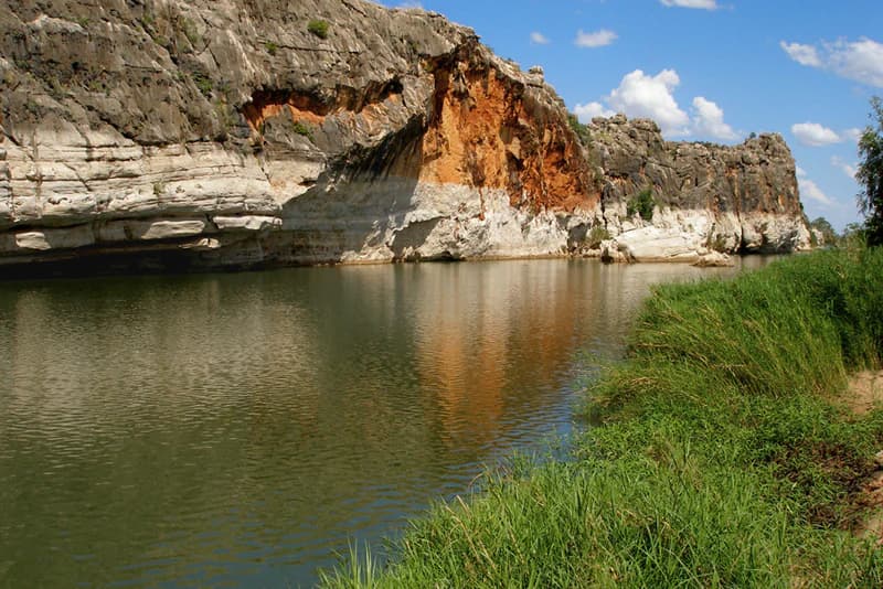
The park is best known for its spectacular Devonian-era limestone gorge, one of the most accessible and visually striking in the Kimberley region. The ancient reef formation, built by extinct organisms rather than corals, represents a unique geological window into Earth's deep past. The gorge also features remarkable seasonal flooding dynamics, with the Fitzroy River's wet season rise clearly visible as white scour marks on the gorge walls. Freshwater crocodiles, sawfish, stingrays, and barramundi inhabit the river, while the riparian vegetation supports diverse birdlife including fruit bats, bowerbirds, and warblers.

Calm river reflecting limestone cliffs and green vegetation on the riverbank under a clear blue sky
Fitzroy River flowing through Danggu Gorge National Park

Danggu (Geikie) Gorge National Park history and protected-area timeline

The gorge carries a dual heritage of colonial geological naming and Indigenous cultural identity. It was first documented by European explorers in 1883 and named in honor of Sir Archibald Geikie, then Director General of the Geological Survey of Great Britain and Ireland. The Bunuba people have known the area as Danggu for generations, a name that translates to mean the area where the water is very deep under the cave. The park was formally established in 1967, providing statutory protection for the geological and natural values of the gorge. In 2023, the park experienced significant damage when the Fitzroy River rose dramatically, reaching heights of 15 meters and permanently altering some sections of the river channel. The flooding destroyed many park facilities, necessitating closure for recovery and rehabilitation. As of early 2024, the park remains closed with plans to reopen sometime during 2024.

Danggu (Geikie) Gorge National Park landscape and geographic character

The physical landscape of Danggu (Geikie) Gorge centers on a dramatic limestone canyon cutting through the backbone of the Napier Range. The gorge walls rise 30 meters from the river level, while the surrounding limestone range stands up to 100 meters above the savanna plains. The reef limestone, formed during the Devonian Period, reaches thicknesses of up to two kilometers in places, representing one of the most substantial ancient reef systems exposed at the Earth's surface. The Fitzroy River continues to actively carve and shape the gorge, with seasonal flood waters depositing visible white scarring on the limestone walls where abrasive flow has stripped the surface. The terrain along the gorge floor is rough and uneven, with the river channel varying in depth and width as it threads through the canyon.

Danggu (Geikie) Gorge National Park ecosystems, habitats, and plant life

The ecological character of the park reflects the intersection of ancient geological formations with ongoing river processes and tropical savanna ecosystems. The Fitzroy River, which flows continuously through the gorge, serves as the lifeblood of the area, supporting abundant aquatic life and creating a verdant riparian corridor through the otherwise dry savanna landscape. The vegetation along the riverbanks includes river gums, freshwater mangroves, pandanus, paperbark, and native figs, with dense reed beds providing habitat for numerous bird species. This riparian zone contrasts sharply with the surrounding Kimberley savanna, creating a lush green corridor that supports wildlife dependent on permanent water. The Devonian limestone geology also contributes to the ecosystem, with fossil-rich strata visible in the gorge walls providing evidence of the ancient marine life that once inhabited this region.

Danggu (Geikie) Gorge National Park wildlife and species highlights

The Fitzroy River flowing through Danggu (Geikie) Gorge supports a notable collection of aquatic species, including large populations of barramundi, sawfish, and freshwater crocodiles. The sawfish found here include the largetooth sawfish, a species of conservation significance, while coach-whip stingrays also inhabit the river channels. Freshwater crocodiles can be observed basking on river banks or swimming in the shallower sections of the waterway. The riparian vegetation provides crucial habitat for various bird species, with fruit bats, great bowerbirds, lilac-crowned wrens, and reed warblers among the avian residents. The combination of permanent water, structurally diverse vegetation, and protection from disturbance makes this stretch of the Fitzroy River particularly important for wildlife in the Kimberley region.

Danggu (Geikie) Gorge National Park conservation status and protection priorities

Danggu (Geikie) Gorge National Park plays a significant role in protecting Kimberley biodiversity and geological heritage. The park is part of the broader Balili (Devonian Reef) Conservation Park network, which recognizes the outstanding universal value of the region's Devonian reef formations. The IUCN designation as Category II reflects the national park's primary objective of protecting natural ecosystems while allowing for sustainable visitor use. The co-management arrangement with Darlngunaya Aboriginal Corporation represents contemporary conservation practice that integrates Indigenous knowledge and cultural values into protected area management. The flood event of 2023 demonstrated both the dynamic natural processes that shape this landscape and the vulnerability of infrastructure to extreme weather events in the Kimberley.

Danggu (Geikie) Gorge National Park cultural meaning and human context

The park holds deep significance for the Bunuba people, the Traditional Owners of the land on which the gorge sits. The Bunuba name Danggu carries specific meaning relating to the place where water runs deep under a cave, reflecting Indigenous knowledge of the landscape's physical and spiritual characteristics. The gorge and surrounding country have been part of Bunuba Country for countless generations, with the river and its resources forming part of ongoing cultural practice and connection. The renaming to Dan͟ggu Geikie Gorge, incorporating both the Bunuba name and the historical European naming, reflects a collaborative approach to recognizing the dual heritage of this place.

Top sights and standout views in Danggu (Geikie) Gorge National Park

The defining highlight of Danggu (Geikie) Gorge is the spectacular canyon landscape carved through ancient Devonian limestone, offering one of the most visually impressive and geologically significant gorges in the Kimberley. The opportunity to see clearly visible flood marks on the gorge walls, showing the dramatic annual rise and fall of the Fitzroy River, provides a tangible connection to the seasonal dynamics that shape this landscape. The accessibility of the gorge, just 20 kilometers from Fitzroy Crossing via a sealed road, makes it a practical destination for visitors to the Kimberley. The presence of freshwater crocodiles, sawfish, and other aquatic wildlife in the clear river waters offers wildlife viewing opportunities that are unique to this riparian environment within the broader arid savanna landscape.

Best time to visit Danggu (Geikie) Gorge National Park

The Kimberley region experiences distinct wet and dry seasons that significantly affect the experience at Danggu (Geikie) Gorge. The dry season, typically from May to October, offers cooler temperatures, lower humidity, and more accessible conditions for walking and wildlife observation. However, the wet season (November to April) brings dramatic river rises that transform the gorge, though high water levels can restrict boat access and certain trail sections. The park has been closed since 2023 due to flood damage, with reopening planned for 2024, so visitors should check current conditions before planning trips. The contrast between the white scour marks on the limestone walls, showing previous flood levels, and the existing water level provides ongoing evidence of the river's seasonal behavior regardless of when one visits.

Park location guide

Geography guide, regional context, and park location map for Danggu (Geikie) Gorge National Park

Danggu (Geikie) Gorge National Park park geography, regions, and map view in Australia
Understand where Danggu (Geikie) Gorge National Park sits in Australia through a broader geographic reading of the surrounding landscape, nearby location context, and its mapped position within the national park landscape.

How Danggu (Geikie) Gorge National Park fits into Australia

Australia is a constitutional monarchy and federal parliamentary democracy comprising six states and ten territories. With a population of nearly 28 million, it is one of the world's most urbanised countries, with most people concentrated on the eastern seaboard. The country has a high Human Development Index and is known for its cultural diversity, ancient Aboriginal heritage, and unique wildlife.

Wider geography shaping Danggu (Geikie) Gorge National Park in Australia

Australia occupies the entire Australian continent, the island of Tasmania, and numerous smaller islands. It is the world's flattest and driest inhabited continent, featuring vast deserts in the interior (the Outback), tropical rainforests along the eastern coast, and a coastline bordering the Indian and Pacific Oceans.

Map view of Danggu (Geikie) Gorge National Park

Use this park location map to pinpoint Danggu (Geikie) Gorge National Park in Australia, understand its exact geographic position, and read its mapped placement within the surrounding landscape more clearly.

Pigeon | © OpenStreetMap contributors

Location context for Danggu (Geikie) Gorge National Park

Western Australia

Visual Reference: Explore Danggu (Geikie) Gorge's Ancient Devonian Reef Landscapes and Riparian Habitats

Danggu (Geikie) Gorge National Park Photos: Explore Dramatic Limestone Landscapes and Unique River Scenery
Browse an immersive collection of photographs showcasing Danggu (Geikie) Gorge National Park, revealing its spectacular limestone canyon, unique Devonian geology, and the Fitzroy River's dynamic riparian environment. These visuals offer a deep understanding of the park's distinct terrain, seasonal flood marks, and the characteristic flora and fauna of this significant Kimberley protected area.

Calm river reflecting limestone cliffs and green vegetation on the riverbank under a clear blue sky

River flowing through a limestone gorge with steep cliffs in the background under clear blue sky

Park atlas

Compare nearby national parks and protected areas, tracing the geological formations and unique riparian ecosystems of the broader Kimberley region.

Explore Related National Parks and Protected Areas Near Danggu (Geikie) Gorge National Park
Browse other national parks and protected areas near Danggu (Geikie) Gorge National Park, focusing on locations throughout Western Australia's distinctive Kimberley region. Expand your geographic understanding of Australia's protected landscapes by comparing similar limestone gorges, river systems, and arid savanna ecosystems across this vast area.
National parkWestern Australia

Bunuba National Park National Park: Mapped Protected Landscape and Regional Geography in Western Australia

Explore its protected land, geographic spread, and mapped boundaries.

Bunuba National Park is a protected area designated as a national park, situated in the vast region of Western Australia. This entry facilitates discovery of its mapped boundaries and the surrounding natural landscape, offering a specific geographic context. Understand how this protected land contributes to the regional atlas of Western Australia, providing a factual representation of its protected area status and landscape character for geographic exploration.

Area
2,200 km²
Established
2023
Scope
Terrestrial
Water
Major water bodies
National parkWestern Australia

Warlibirri National Park: Western Australia's Protected Landscape and Geographic Atlas Entry

Discover mapped boundaries and regional context within Western Australia.

Warlibirri National Park represents a distinct protected landscape within the vast geography of Western Australia. As a designated national park, it offers a specific point of atlas-driven exploration, detailing its geographic scope and protected status. This entry focuses on the core elements of Warlibirri National Park's identity for users seeking structured geographic and mapped landscape information.

Area
158.95 km²
Established
2021
Scope
Terrestrial
Water
Major water bodies
National parkWestern Australia

Tunnel Creek National Park: Ancient Devonian Reef Caves and Aboriginal Heritage

Discover Western Australia's ancient geological and cultural protected landscape.

Tunnel Creek National Park offers a unique glimpse into geological time and Aboriginal heritage, centered on an ancient underground river flowing through the Napier Range. This National Park features one of Western Australia's oldest cave systems, carved from fossilized Devonian reef limestone dating back 350 million years. Explore the remarkable 750-meter cave tunnel, marvel at its speleothems, and appreciate the significant rock art that tells stories of its cultural past. The park's protected status safeguards this extraordinary geological formation and its historical narratives for continued exploration.

Area
0.91 km²
Established
1992
IUCN
II
Relief
Upland
National parkWestern Australia

Windjana Gorge National Park: Ancient Devonian Reef Gorge Landscape Exploration

Explore mapped geography and fossil-rich sandstone formations.

Windjana Gorge National Park offers an unparalleled opportunity to explore a protected landscape defined by its ancient Devonian reef origins. Situated in Western Australia, this national park protects a dramatic gorge carved through fossil-rich sandstone, revealing a 375-million-year-old geological past. Examine the mapped park boundaries and the unique contours of this ancient reef system, providing crucial context for understanding the natural history and landscape evolution of the Kimberley region.

Area
20.5 km²
Established
1971
IUCN
II
Relief
Lowland
National parkWestern Australia

Wolfe Creek Crater National Park: Protected Landscape and Geographic Atlas Entry

Explore mapped protected boundaries and regional geography.

Access detailed geographic information for Wolfe Creek Crater National Park, a significant national park in Western Australia. This entry focuses on the park's protected landscape identity, its precise mapped boundaries, and its contribution to the regional geography of Australia. Understand its unique setting within the vast Western Australian landscape, aiding in atlas-based discovery and geographic context.

Area
14.6 km²
Established
1969
IUCN
III
Relief
Lowland
National parkWestern Australia

Prince Regent National Park: Protected Landscape and Geographic Context in Western Australia

Explore mapped boundaries of this Western Australian national park.

Prince Regent National Park represents a distinct protected area within the expansive territory of Western Australia. This national park serves as a focal point for understanding regional geography and mapped landscape features. Users can explore its specific park boundaries and discover its contribution to the atlas of Western Australia's natural heritage, offering a deep dive into its protected status and geographic placement.

Area
5,764 km²
Established
1964
IUCN
II
Relief
Mountain
National parkWestern Australia

Purnululu National Park: National Park Atlas and Mapped Protected Landscape

Explore Western Australia's Purnululu National Park geography.

Gain a structured atlas-style understanding of Purnululu National Park, a key protected area in Western Australia. This page details the park's geographic identity, its role as a national park, and its relationship to the surrounding regional landscapes. Engage with mapped park boundaries and factual context to appreciate its place in the broader Australian conservation geography.

Area
2,397.23 km²
Established
1987
IUCN
II
Relief
Mountain
National parkWestern Australia

Drysdale River National Park: Western Australia National Park Geographic Atlas Entry

Mapped protected landscape and regional context.

Delve into the protected landscape of Drysdale River National Park, a designated national park located in Western Australia. This page serves as a focused entry point for understanding its geographic placement, mapped boundaries, and contribution to the broader regional atlas. Explore the specific terrain and protected area context of Drysdale River National Park, aiding in structured geographic discovery within Australia's vast natural areas.

Area
4,482.64 km²
Established
1974
IUCN
II
Relief
Mountain

Common questions about visiting, size, designation, and location context for Danggu (Geikie) Gorge National Park

Danggu (Geikie) Gorge National Park FAQs for park facts, access, geography, and protected area context
Find quick answers about Danggu (Geikie) Gorge National Park, including protected-area facts, park geography, trail and visitor context, and how the park fits into its surrounding country and regional landscape.
MoriAtlas Explorer

Continue Your Protected Areas Search Across the Global Atlas

Deepen your exploration by continuing the structured search for national parks and protected areas worldwide. Utilize the comprehensive filtering capabilities to compare different conservation landscapes and refine your understanding of global park geography. Discover more about the distribution and characteristics of protected natural areas.

Global natural geography