Mori Atlas logo
National parkWolfe Creek Crater National Park

Discover the unique geographic identity and protected boundaries of Wolfe Creek Crater National Park in Western Australia.

Wolfe Creek Crater National Park: Mapped Protected Landscape and Regional Geography

Wolfe Creek Crater National Park represents a distinct protected landscape within the vast geography of Western Australia. This page provides an atlas-oriented view, detailing the park's mapped boundaries and its place within the broader regional context of Australia's largest state. Understand the unique natural terrain and protected-area significance of this iconic national park through structured geographic data and landscape perspectives.

meteorite craterdesert landscapeWestern Australiageological heritageKimberley regionnatural monument

Wolfe Creek Crater National Park

National park

Park overview

Structured park overview, official facts, and landscape profile for Wolfe Creek Crater National Park

Wolfe Creek Crater National Park park facts, protected area profile, and essential visitor context
Review the core facts for Wolfe Creek Crater National Park, including designation, size, terrain, visitor scale, habitats, and operating context in one park-focused overview.

About Wolfe Creek Crater National Park

Wolfe Creek Crater National Park protects an extraordinary geological feature in one of Australia's most remote desert landscapes. The park lies on the edge of the Great Sandy Desert, a vast expanse of sand ridges, rocky plains and sparse vegetation that defines much of inland northern Western Australia. The crater itself is a near-circular depression with clearly defined raised rims, standing in stark contrast to the flat desert surroundings. This visual drama, combined with the scientific importance of the site, makes Wolfe Creek one of the most distinctive protected areas in Australia. The park offers visitors the opportunity to walk to the crater rim and gaze down into this ancient impact structure, a experience that connects the viewer directly with cosmic forces that shaped Earth's geological history. The desert environment surrounding the crater is characterised by red sand plains covered in spinifex grass, with scattered rocky outcrops of ancient Precambrian bedrock. The park provides essential protection for this unique combination of astronomical and desert landscapes.

Quick facts and research context for Wolfe Creek Crater National Park

Wolfe Creek Crater National Park was established in 1969 and covers an area of 14.6 square kilometres. It is classified as an IUCN Category III protected area, recognising its status as a natural monument of national significance. The park is managed by the Western Australian Department of Environment and Conservation. The nearest town is Halls Creek, located about 145 kilometres to the north. Access is via the Tanami Road, a remote desert road that requires careful preparation for visitors. The park is one of the most scientifically valuable impact craters in the world due to its excellent preservation and accessibility.

Park context

Deeper park guide and search-rich context for Wolfe Creek Crater National Park

Wolfe Creek Crater National Park history, landscape, wildlife, and travel context
Explore Wolfe Creek Crater National Park through its history, landscape character, ecosystems, wildlife, conservation priorities, cultural context, and seasonal travel timing in a structured park guide built for atlas discovery and search intent.

Why Wolfe Creek Crater National Park stands out

Wolfe Creek Crater is world-renowned as one of the finest examples of a meteorite impact crater on Earth. The crater measures approximately 875 metres in diameter and reaches about 60 metres deep from the rim, with the crater floor lying about 25 metres below the surrounding desert surface. The impact that created the crater is estimated to have involved a meteorite roughly 15 metres in diameter, striking the ancient landscape with enormous force. The crater's rim rises about 25 metres above the surrounding sand plain, and the central uplift of bedrock in the crater's centre provides crucial evidence of the violent impact event. This site offers scientists rare insights into impact mechanics while providing visitors with an unforgettable view of one of nature's most dramatic geological scars.

Warning sign reading "Trail Risk Area" in foreground with crater visible in background across grassy and rocky landscape under partly cloudy sky
Wolfe Creek Crater with trail risk warning sign in foreground

Wolfe Creek Crater National Park history and protected-area timeline

Wolfe Creek Crater was first described by European explorers in 1947, with scientific investigations beginning shortly thereafter. The park was formally established in 1969 to protect the crater and its surrounding desert environment. Prior to European settlement, the crater was known to local Aboriginal peoples and forms part of the cultural landscape of the region. The establishment of the park reflected growing recognition of the crater's scientific importance as one of the world's best-preserved meteorite impact sites. Management of the park has focused on preserving the geological integrity of the crater while providing appropriate visitor access. The Western Australian Department of Environment and Conservation maintains facilities including walking tracks and viewing areas that allow visitors to experience the crater while minimising impact on the site.

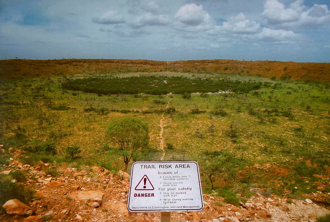
Wolfe Creek Crater National Park landscape and geographic character

The landscape of Wolfe Creek Crater National Park is defined by the dramatic contrast between the near-perfect circular crater and the vast, flat expanse of the surrounding Great Sandy Desert. The desert plains are covered in red-orange sand with sparse vegetation dominated by spinifex grasslands and scattered low shrubs. The crater itself rises abruptly from the desert floor, its raised rim composed of fragmented bedrock and debris ejected during the impact event. The crater interior shows distinct layering, with the floor covered in sand and debris while the steep walls expose bedrock that was compressed and then ejected during the impact. Outside the crater, the terrain remains remarkably flat, with ancient geological formations of the Pilbara region visible on the horizon. The overall impression is one of ancient, timeless desert solitude, with the crater providing a singular focus of visual interest in an otherwise uniform landscape.

Wolfe Creek Crater National Park ecosystems, habitats, and plant life

The park lies within the Great Sandy Desert bioregion, an environment of extreme aridity and high temperatures that supports specially adapted plant and animal life. The sparse vegetation is dominated by spinifex grass, which forms hummock-like clumps across the sand plains, interspersed with low shrubs and isolated trees in drainage lines. The desert environment experiences very low rainfall, with most precipitation occurring during brief summer thunderstorms. Vegetation patterns reflect the availability of moisture, with denser growth occurring in areas where water naturally accumulates. The park provides protection for this desert ecosystem, preserving a representative sample of the unique flora and fauna that have adapted to the harsh interior conditions of northern Western Australia.

Wolfe Creek Crater National Park wildlife and species highlights

The desert environment of Wolfe Creek Crater National Park supports a range of wildlife adapted to arid conditions, though species diversity is naturally limited by the harsh climate. Reptiles including goannas and snakes are the most commonly observed vertebrate groups, having evolved behaviours and physiologies that allow them to survive with minimal water. Desert birds such as bustards and sandpipers may be seen in the early morning or evening, while small mammals like hopping mice and dunnarts are active during cooler periods. The crater itself provides a slightly different habitat, with more sheltered conditions and accumulation of moisture supporting some additional plant growth that attracts wildlife. The overall wildlife community reflects the adaptations necessary for survival in one of Australia's most challenging environments.

Wolfe Creek Crater National Park conservation status and protection priorities

Wolfe Creek Crater National Park is designated as an IUCN Category III protected area, recognising the crater as a natural monument of national and international significance. The park protects one of the clearest and most scientifically valuable meteorite impact craters on Earth, providing researchers with access to study impact processes and ancient cosmic events. Beyond the crater itself, the park preserves a representative sample of Great Sandy Desert landscape, protecting the desert ecosystem and its native species. The protection status ensures that the geological integrity of the crater is maintained and that the site remains available for scientific study and public education. The park represents an important contribution to Australia's protected area network, preserving both a unique geological feature and a remote desert environment.

Wolfe Creek Crater National Park cultural meaning and human context

The region surrounding Wolfe Creek Crater has been inhabited by Aboriginal peoples for tens of thousands of years, with the crater holding cultural significance for local communities. The traditional name for the area relates to the creation narratives of the indigenous people, though detailed cultural information should be understood through appropriate engagement with Traditional Custodians. European knowledge of the crater dates to the mid-twentieth century, with scientific documentation beginning in the 1940s. The establishment of the park in 1969 reflected growing appreciation for both the scientific importance and natural beauty of the site. The cultural context of the park includes both this recent scientific history and the deeper indigenous connection to the landscape, though the primary focus remains on the geological significance of the crater.

Top sights and standout views in Wolfe Creek Crater National Park

The central experience at Wolfe Creek Crater National Park is the opportunity to view and walk around one of the world's most visually impressive meteorite impact craters. The walk to the crater rim provides gradually unfolding views of this ancient impact scar, with the circular depression becoming increasingly impressive as visitors approach. The view from the rim looking down into the crater, with its central uplift and layered walls, offers a profound sense of the cosmic violence that created this landscape. The desert setting adds to the experience, with the vast, empty landscape reinforcing the sense of isolation and the magnitude of geological time. The park provides a rare opportunity to directly experience evidence of cosmic impacts on Earth's surface in a setting of stark natural beauty.

Best time to visit Wolfe Creek Crater National Park

The best time to visit Wolfe Creek Crater National Park is during the cooler months from April to September, when daytime temperatures are more moderate and comfortable for walking. Summer temperatures in the desert can exceed 40 degrees Celsius, making outdoor activity dangerous and uncomfortable. The dry season generally provides clearer skies and more predictable conditions, though the park can be visited year-round with appropriate preparation. Visitors should be aware that the park is remote, with limited facilities and long distances between services. Adequate water supplies, appropriate vehicle preparation, and awareness of desert conditions are essential for a safe visit. The winter months offer the most pleasant conditions for exploring the crater and surrounding landscape.

Park location guide

Geography guide, regional context, and park location map for Wolfe Creek Crater National Park

Wolfe Creek Crater National Park park geography, regions, and map view in Australia
Understand where Wolfe Creek Crater National Park sits in Australia through a broader geographic reading of the surrounding landscape, nearby location context, and its mapped position within the national park landscape.

How Wolfe Creek Crater National Park fits into Australia

Australia is a constitutional monarchy and federal parliamentary democracy comprising six states and ten territories. With a population of nearly 28 million, it is one of the world's most urbanised countries, with most people concentrated on the eastern seaboard. The country has a high Human Development Index and is known for its cultural diversity, ancient Aboriginal heritage, and unique wildlife.

Wider geography shaping Wolfe Creek Crater National Park in Australia

Australia occupies the entire Australian continent, the island of Tasmania, and numerous smaller islands. It is the world's flattest and driest inhabited continent, featuring vast deserts in the interior (the Outback), tropical rainforests along the eastern coast, and a coastline bordering the Indian and Pacific Oceans.

Map view of Wolfe Creek Crater National Park

Use this park location map to pinpoint Wolfe Creek Crater National Park in Australia, understand its exact geographic position, and read its mapped placement within the surrounding landscape more clearly.

Pigeon | © OpenStreetMap contributors

Location context for Wolfe Creek Crater National Park

Western Australia

Detailed Visuals of Western Australia's Remote Protected Area, Tracing Its Unique Crater Terrain and Desert Habitats

Visual Exploration of Wolfe Creek Crater National Park: Striking Desert Landscapes and Meteorite Impact Geology
Visually explore Wolfe Creek Crater National Park, a protected area defined by one of Earth's most striking meteorite impact craters, situated within the vast Great Sandy Desert. This gallery offers detailed views of the park's dramatic geological formations, surrounding red sand plains, and the unique desert habitats that characterize its remote Western Australian environment.

Warning sign reading "Trail Risk Area" in foreground with crater visible in background across grassy and rocky landscape under partly cloudy sky

Park atlas

Compare other protected areas and regional park geography within Western Australia's remote interior.

Discover Other National Parks and Protected Areas Near Wolfe Creek Crater National Park
Extend your exploration beyond Wolfe Creek Crater National Park to discover other protected areas and national parks within Western Australia's remote Kimberley region. Map the regional spread of diverse desert landscapes, compare geological heritage sites, and trace the unique conservation geography of this vast Australian interior.
National parkWestern Australia

Warlibirri National Park: Western Australia's Protected Landscape and Geographic Atlas Entry

Discover mapped boundaries and regional context within Western Australia.

Warlibirri National Park represents a distinct protected landscape within the vast geography of Western Australia. As a designated national park, it offers a specific point of atlas-driven exploration, detailing its geographic scope and protected status. This entry focuses on the core elements of Warlibirri National Park's identity for users seeking structured geographic and mapped landscape information.

Area
158.95 km²
Established
2021
Scope
Terrestrial
Water
Major water bodies
National parkWestern Australia

Purnululu National Park: National Park Atlas and Mapped Protected Landscape

Explore Western Australia's Purnululu National Park geography.

Gain a structured atlas-style understanding of Purnululu National Park, a key protected area in Western Australia. This page details the park's geographic identity, its role as a national park, and its relationship to the surrounding regional landscapes. Engage with mapped park boundaries and factual context to appreciate its place in the broader Australian conservation geography.

Area
2,397.23 km²
Established
1987
IUCN
II
Relief
Mountain
National parkWestern Australia

Bunuba National Park National Park: Mapped Protected Landscape and Regional Geography in Western Australia

Explore its protected land, geographic spread, and mapped boundaries.

Bunuba National Park is a protected area designated as a national park, situated in the vast region of Western Australia. This entry facilitates discovery of its mapped boundaries and the surrounding natural landscape, offering a specific geographic context. Understand how this protected land contributes to the regional atlas of Western Australia, providing a factual representation of its protected area status and landscape character for geographic exploration.

Area
2,200 km²
Established
2023
Scope
Terrestrial
Water
Major water bodies
National parkWestern Australia

Danggu (Geikie) Gorge National Park: Western Australia's Protected Landscape Atlas

Explore the geography and mapped boundaries of this national park.

Danggu (Geikie) Gorge National Park is a vital protected area situated within the diverse geography of Western Australia. This entry provides a detailed atlas perspective, focusing on the park's mapped boundaries and its distinct landscape character. Explore the regional context and understand how this national park contributes to the protected lands of Western Australia, offering a grounded approach to geographic discovery.

Area
31.36 km²
Established
1967
IUCN
II
Relief
Mixed relief
National parkWestern Australia

Tunnel Creek National Park: Ancient Devonian Reef Caves and Aboriginal Heritage

Discover Western Australia's ancient geological and cultural protected landscape.

Tunnel Creek National Park offers a unique glimpse into geological time and Aboriginal heritage, centered on an ancient underground river flowing through the Napier Range. This National Park features one of Western Australia's oldest cave systems, carved from fossilized Devonian reef limestone dating back 350 million years. Explore the remarkable 750-meter cave tunnel, marvel at its speleothems, and appreciate the significant rock art that tells stories of its cultural past. The park's protected status safeguards this extraordinary geological formation and its historical narratives for continued exploration.

Area
0.91 km²
Established
1992
IUCN
II
Relief
Upland
National parkWestern Australia

Windjana Gorge National Park: Ancient Devonian Reef Gorge Landscape Exploration

Explore mapped geography and fossil-rich sandstone formations.

Windjana Gorge National Park offers an unparalleled opportunity to explore a protected landscape defined by its ancient Devonian reef origins. Situated in Western Australia, this national park protects a dramatic gorge carved through fossil-rich sandstone, revealing a 375-million-year-old geological past. Examine the mapped park boundaries and the unique contours of this ancient reef system, providing crucial context for understanding the natural history and landscape evolution of the Kimberley region.

Area
20.5 km²
Established
1971
IUCN
II
Relief
Lowland
National parkWestern Australia

Drysdale River National Park: Western Australia National Park Geographic Atlas Entry

Mapped protected landscape and regional context.

Delve into the protected landscape of Drysdale River National Park, a designated national park located in Western Australia. This page serves as a focused entry point for understanding its geographic placement, mapped boundaries, and contribution to the broader regional atlas. Explore the specific terrain and protected area context of Drysdale River National Park, aiding in structured geographic discovery within Australia's vast natural areas.

Area
4,482.64 km²
Established
1974
IUCN
II
Relief
Mountain
National parkWestern Australia

Prince Regent National Park: Protected Landscape and Geographic Context in Western Australia

Explore mapped boundaries of this Western Australian national park.

Prince Regent National Park represents a distinct protected area within the expansive territory of Western Australia. This national park serves as a focal point for understanding regional geography and mapped landscape features. Users can explore its specific park boundaries and discover its contribution to the atlas of Western Australia's natural heritage, offering a deep dive into its protected status and geographic placement.

Area
5,764 km²
Established
1964
IUCN
II
Relief
Mountain

Common questions about visiting, size, designation, and location context for Wolfe Creek Crater National Park

Wolfe Creek Crater National Park FAQs for park facts, access, geography, and protected area context
Find quick answers about Wolfe Creek Crater National Park, including protected-area facts, park geography, trail and visitor context, and how the park fits into its surrounding country and regional landscape.
MoriAtlas Explorer

Continue Your Protected Areas Search Across the Global Atlas

Deepen your exploration by continuing the structured search for national parks and protected areas worldwide. Utilize the comprehensive filtering capabilities to compare different conservation landscapes and refine your understanding of global park geography. Discover more about the distribution and characteristics of protected natural areas.

Global natural geography