
Why Flatside Wilderness stands out
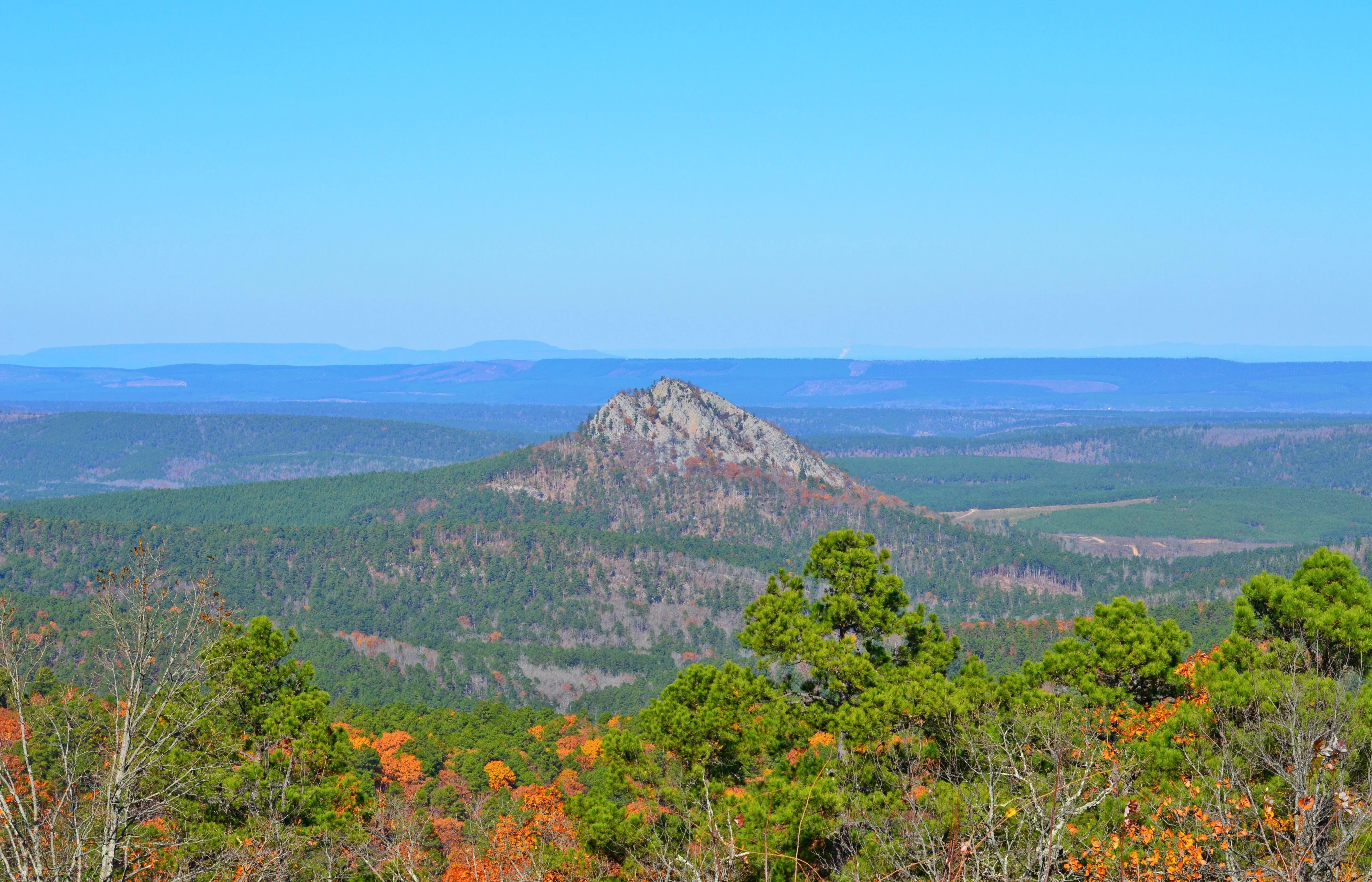
Flatside Wilderness is best known for its dramatic sandstone ridges within the Ouachita Mountains, where broad summits such as White Oak Mountain, Crystal Mountain, Grindstone Mountain, Flatside Pinnacle, and Forked Mountain rise sharply above surrounding forest. These high points offer sweeping vistas, including distant views of Mount Magazine, the highest point in Arkansas, on clear days. The wilderness is also recognized for its inclusion in the Ouachita National Recreation Trail, an 8.9-mile segment of which passes through the area, and for its relatively undisturbed stream corridors along Cedar Creek and Crystal Prong. Together these features make it a defining eastern anchor of the Ouachita National Forest wilderness system.
Flatside Wilderness history and protected-area timeline
Flatside Wilderness was established through the Arkansas Wilderness Act of 1984, signed into law by President Ronald Reagan on October 19, 1984. The bill, enacted as Public Law 98-508, was sponsored in the U.S. Senate by Senator Dale Bumpers of Arkansas and co-sponsored by Senators David Pryor of Arkansas and John Tower of Texas. An earlier version of the legislation, the Arkansas Wilderness Act of 1983, had been introduced in the House of Representatives by Representative Beryl Anthony and Representative Ed Bethune, both from Arkansas.
On September 8, 2019, a bill sponsored by Congressman French Hill expanded the wilderness area by 640 acres. This added portion was named the Bethune Woods segment in recognition of Ed Bethune's earlier role in supporting the original wilderness designation. The same legislation directed the U.S. Forest Service to study additional surrounding woodlands to evaluate their potential for future inclusion in the wilderness system.
The wilderness takes its name from Flatside Pinnacle, a prominent overlook that lies just outside the formal wilderness boundary and is widely regarded as one of the most scenic vistas in Arkansas.
Flatside Wilderness landscape and geographic character
Flatside Wilderness occupies a portion of the Ouachita Mountains where the regional geology produces a rugged, high-relief landscape of long ridges and narrow valleys. Several named summits shape the visual character of the area, with White Oak Mountain forming a broad ridge along the western edge of the wilderness at 1,790 feet. Other significant peaks include Crystal Mountain, Grindstone Mountain, Flatside Pinnacle, and Forked Mountain, all rising above the surrounding forest in descending order of elevation.
Ridgetops throughout the wilderness are dominated by resistant Jackfork Sandstone, a Pennsylvanian-age quartz-rich formation that has weathered slowly compared to the surrounding Stanley Shale. This contrast in erosion rates has produced the area's prominent sandstone ridges, which stand distinctly above softer, shale-influenced slopes and valleys. The result is a landscape of layered, exposed rock near summits and deeply forested hollows below.
The drainage network of the wilderness adds further definition to its terrain. Cedar Creek, augmented by Little Cedar Creek, traces the eastern base of Forked Mountain before flowing into the South Fourche La Fave River, while Crystal Prong runs generally east to west and joins Cedar Creek near Forked Mountain. Together, these streams carve the valleys that separate the area's principal ridges and feed into the larger Fourche La Fave and Arkansas River systems.
Flatside Wilderness ecosystems, habitats, and plant life
The vegetation of Flatside Wilderness reflects the mixed hardwood and pine forests typical of the Ouachita Mountains in central Arkansas. The combination of sandstone-dominated ridgetops, shale-influenced slopes, and well-watered stream corridors supports a varied forest mosaic across the wilderness. Upland ridges are typically clad in drier, rock-influenced forest communities, while valleys and stream environments support richer, more mesic plant assemblages.
The wilderness's protected status under federal wilderness designation has helped maintain forest conditions with minimal active management, allowing ecological processes such as natural tree regeneration, stream dynamics, and wildlife movement to function with relatively limited human interference. This makes Flatside a useful reference area for understanding Ouachita forest composition and recovery patterns in a setting where natural disturbance regimes remain largely intact.
Because the area lies along the eastern edge of the Ouachita National Forest, it also serves as an ecological transition zone between Ouachita uplands and the lower-elevation landscapes of central Arkansas. This positioning contributes to the diversity of forest types present within a relatively compact geographic area.
Flatside Wilderness wildlife and species highlights
Wildlife in Flatside Wilderness is characteristic of forested Ouachita Mountain habitats, where mature hardwood-pine mixes, rocky ridges, and perennial streams provide a range of conditions for native species. The wilderness's mix of upland ridges and stream valleys supports animals associated with both dry, rocky terrain and more sheltered, water-influenced environments.
The area's streams, particularly Cedar Creek and Crystal Prong, contribute aquatic habitat values that connect to the broader Fourche La Fave River watershed. These waterways support native aquatic life and provide important riparian corridors through the otherwise upland-dominated terrain. Forested slopes and ridgetops support breeding habitat for songbirds and other woodland species typical of the central Arkansas region.
Because the wilderness has remained relatively undisturbed since its 1984 designation, it offers a setting in which wildlife patterns can develop under largely natural conditions, adding to its value as both a recreational and ecological resource within the Ouachita National Forest system.
Flatside Wilderness conservation status and protection priorities
Flatside Wilderness holds conservation significance as one of six designated wilderness areas within the Ouachita National Forest and the easternmost of those areas. Its federal wilderness designation, originally conferred by the Arkansas Wilderness Act of 1984, places it under the highest level of protection available to U.S. Forest Service lands, restricting road construction, mechanized use, and most forms of development.
The 2019 expansion that added the Bethune Woods segment further strengthened the wilderness's role as a protected landscape anchor, while the accompanying direction to study nearby woodlands for potential future inclusion reflects ongoing interest in consolidating ecological protection around the area. The wilderness's location along the eastern terminus of the Ouachita National Forest gives it additional conservation importance as a relatively intact forested transition between mountain and lowland ecosystems in central Arkansas.
Geologically, the area's sandstone ridges and shale valleys preserve an example of Ouachita Mountain terrain largely free from active resource extraction and infrastructure. Combined with its continuous forested cover and free-flowing streams, this protection supports watershed function, habitat connectivity, and the long-term persistence of Ouachita forest communities.
Flatside Wilderness cultural meaning and human context
The cultural context of Flatside Wilderness is closely tied to the broader identity of the Ouachita Mountains, a region long valued in Arkansas for its scenic landscapes and outdoor recreation traditions. The naming of the 2019 expansion as the Bethune Woods segment, in honor of former Representative Ed Bethune, reflects the role of Arkansas's political figures in shaping modern conservation protections in the state.
The wilderness also plays a part in the regional outdoor recreation culture of central Arkansas. Because it lies within relatively easy reach of the Little Rock metropolitan area, it functions as a nearby backcountry destination for residents of the state's capital region, integrating wilderness values into everyday outdoor life for many Arkansans.
Top sights and standout views in Flatside Wilderness
Flatside Wilderness stands out for its concentration of high sandstone ridges within a compact area, including White Oak Mountain, Crystal Mountain, Grindstone Mountain, Flatside Pinnacle, and Forked Mountain. Its 8.9-mile segment of the Ouachita National Recreation Trail connects the wilderness to a longer regional hiking route, while scenic vistas from nearby Flatside Pinnacle are widely regarded among the most striking in Arkansas.
The wilderness's protected status, recent expansion through the Bethune Woods segment, and position as the easternmost wilderness in the Ouachita National Forest further distinguish it as a meaningful addition to Arkansas's system of conserved landscapes.
Best time to visit Flatside Wilderness
Spring and fall are generally the most rewarding seasons to experience Flatside Wilderness, when moderate temperatures and stable footing make hiking along the Ouachita National Recreation Trail segment and exploring ridgetop overlooks more comfortable. Spring brings refreshed stream flow, leaf-out across the hardwood canopy, and active woodland birdlife, while autumn offers cooler air and changing foliage color against the dark sandstone outcrops.
Summer visits remain possible but can be hot and humid in central Arkansas, and ridge-top hikes under direct sun are more demanding. Winter brings the quietest conditions and clearest overlooks, including potential distant views of Mount Magazine on particularly clear days, though shorter daylight hours and occasional freezes can affect trail conditions.