Mori Atlas logo
Protected areaWinding Stair Mountain National Recreation Area

A rugged forested ridge system defining the mountainous terrain of southeastern Oklahoma.

Winding Stair Mountain National Recreation Area: Mapping the Ouachita Highlands and Protected Landscapes

Winding Stair Mountain National Recreation Area encompasses over 26,000 acres of protected Ouachita mountain terrain in Oklahoma. This recreation area protects a unique landscape of pine and hardwood forests, steep sandstone ridgelines, and upland valleys. By tracing the winding ridges that give the area its name, this geographic overview provides insight into the complex topography and the network of trails that define this critical protected segment of the Ouachita highlands.

Ouachita Mountainsmountain recreation areascenic bywaypine and hardwood foresthiking trailsbackcountry camping

Winding Stair Mountain National Recreation Area

Protected area

Park overview

Structured park overview, official facts, and landscape profile for Winding Stair Mountain National Recreation Area

Winding Stair Mountain National Recreation Area park facts, protected area profile, and essential visitor context

Review the core facts for Winding Stair Mountain National Recreation Area, including designation, size, terrain, visitor scale, habitats, and operating context in one park-focused overview.

About Winding Stair Mountain National Recreation Area

Winding Stair Mountain National Recreation Area sits in the Ouachita Mountains of southeastern Oklahoma, embedded within the much larger Ouachita National Forest that stretches across Oklahoma and Arkansas. It takes its name from the Winding Stair Mountains, an east-west oriented ridge whose serpentine profile resembles a staircase climbing into the forested highlands. The recreation area is most often encountered by visitors driving the Talimena Scenic Byway, a designated scenic corridor along State Highway 1 that follows the high ridges through the recreation area and on into Arkansas, with U.S. Highway 271 looping up toward the summit from below.

Beyond its scenic driving appeal, the recreation area functions as a multi-use outdoor recreation hub. Its roughly 26,445 acres include several campgrounds, an approximately 85-acre lake, and a dense network of hiking trails, including a 45-mile segment of the longer Ouachita National Recreation Trail that passes through the area. Activities range from traditional pursuits such as camping, hiking, fishing, and hunting to more distinctive uses like hang-gliding from the ridge tops, reflecting the open, elevated character of the terrain.

The area's ecological and recreational significance is tied to its position within one of the major forested mountain systems of the south-central United States. Mixed pine and hardwood forests, rocky stream valleys, and exposed sandstone ridge lines support both wildlife habitat and a varied visitor experience. Because Winding Stair Mountain was established at the same time as the Upper Kiamichi River Wilderness and the Black Fork Mountain Wilderness, it is now part of a connected cluster of protected landscapes, with the recreation area acting as a more accessible, road-connected complement to the more strictly managed wilderness tracts around it.

Quick facts and research context for Winding Stair Mountain National Recreation Area

Winding Stair Mountain National Recreation Area lies within Ouachita National Forest in Le Flore County, southeastern Oklahoma, near the town of Talihina. It encompasses about 26,445 acres of Ouachita mountain terrain centered on the Winding Stair Mountains.

The area was established by Congress on October 18, 1988, in the same legislation that created the Upper Kiamichi River Wilderness and Black Fork Mountain Wilderness. It is administered by the U.S. Forest Service and contains campgrounds, an approximately 85-acre lake, numerous hiking trails, and a 45-mile segment of the Ouachita National Recreation Trail.

Protection and recognition

Documented terrestrial conservation boundaries and international recognition records

Winding Stair Mountain National Recreation Area Protection Status and Management Scope

Terrestrial protection status and administrative management parameters define the conservation scope of Winding Stair Mountain National Recreation Area. Structured designation facts provide clear reference data regarding official boundaries and international recognition frameworks.

Protection details

Protection scope
Terrestrial
Transboundary protection
No
Park context

Deeper park guide and search-rich context for Winding Stair Mountain National Recreation Area

Winding Stair Mountain National Recreation Area history, landscape, wildlife, and travel context

Explore Winding Stair Mountain National Recreation Area through its history, landscape character, ecosystems, wildlife, conservation priorities, cultural context, and seasonal travel timing in a structured park guide built for atlas discovery and search intent.

Why Winding Stair Mountain National Recreation Area stands out

Winding Stair Mountain National Recreation Area is best known for the Talimena Scenic Byway, a ridge-top driving route that runs through the heart of the Ouachita Mountains and offers sweeping vistas across the surrounding forest landscape. The recreation area's name comes from the winding, staircase-like profile of the mountain ridge itself. It is also recognized as a gateway to backcountry Ouachita experiences, combining road-accessible scenery with a long stretch of the Ouachita National Recreation Trail, multiple campgrounds, and access to nearby designated wilderness areas that together form one of Oklahoma's most concentrated mountain recreation complexes.

Winding Stair Mountain National Recreation Area history and protected-area timeline

Winding Stair Mountain National Recreation Area was created by an act of the United States Congress on October 18, 1988. The same legislation simultaneously established two adjoining protected landscapes, the Upper Kiamichi River Wilderness to the south and the Black Fork Mountain Wilderness in the surrounding Ouachita highlands, recognizing the area as part of a broader conservation cluster in southeastern Oklahoma.

Since its establishment, the recreation area has been managed by the United States Forest Service as a unit of the Ouachita National Forest. Over time, it has come to be defined less by individual landmarks and more by its role as a road-based scenic corridor and recreation destination, particularly through the association with the Talimena Scenic Byway and its integration into the longer Ouachita National Recreation Trail system.

Winding Stair Mountain National Recreation Area landscape and geographic character

The landscape of Winding Stair Mountain National Recreation Area is defined by the east-west running Winding Stair Mountains, a ridge system within the Ouachita Uplands of southeastern Oklahoma. The ridge line gives the area both its name and its visual identity, with long, winding ridgelines that climb and descend in a pattern resembling a natural staircase. From these heights, visitors look out across rolling, heavily forested terrain that extends into the surrounding Ouachita National Forest.

Within the recreation area, the topography varies from exposed sandstone ridge tops to lower stream valleys and hollows lined with mixed forest. An approximately 85-acre lake sits within the recreation area, adding a water-based element to an otherwise mountainous setting, while smaller streams drain the ridge flanks. The combination of ridgeline driving routes, including the Talimena Scenic Byway along State Highway 1 and the looping U.S. Highway 271, gives visitors multiple ways to experience the vertical dimension of the landscape.

Winding Stair Mountain National Recreation Area ecosystems, habitats, and plant life

Ecologically, Winding Stair Mountain sits within the Ouachita Mountains, a region known for its mix of pine and hardwood forests growing on often rocky, acidic soils derived from underlying sandstone and shale. The recreation area's forests are characteristic of this Ouachita setting, with ridges and slopes supporting different combinations of upland pines and hardwood coves depending on elevation, aspect, and soil depth.

The terrain supports a variety of habitat types in a relatively compact area, from dry, exposed ridgetops to shaded ravines and streamside corridors. The presence of the area's lake and connected streams adds aquatic and riparian habitat to the predominantly forested landscape. Because Winding Stair Mountain is bordered by the Upper Kiamichi River Wilderness and the Black Fork Mountain Wilderness, its ecological value is reinforced by being part of a larger, contiguous block of protected Ouachita habitat.

Winding Stair Mountain National Recreation Area wildlife and species highlights

The mixed pine and hardwood forests of Winding Stair Mountain National Recreation Area support wildlife typical of the Ouachita Mountains, including a combination of forest-interior species, edge-habitat species, and animals associated with streams and ridges. The area's network of trails and backcountry roads, combined with the adjoining wilderness areas, makes the recreation area a meaningful habitat block for species that depend on large, contiguous tracts of southern Appalachian-Ouachita forest.

In addition to common forest wildlife, the recreation area is known for game species pursued through regulated hunting, including deer and other game animals drawn to the mix of woodland and openings. Birdlife associated with both pine woodland and hardwood habitats can be expected, and the lake and stream corridors provide habitat for fish and other aquatic life associated with regional fishing traditions.

Winding Stair Mountain National Recreation Area conservation status and protection priorities

Winding Stair Mountain National Recreation Area was created as part of a broader conservation effort to preserve and provide public access to the Ouachita Mountains of southeastern Oklahoma. By establishing the recreation area alongside the Upper Kiamichi River Wilderness and the Black Fork Mountain Wilderness in a single 1988 act of Congress, legislators recognized that maintaining the Ouachita landscape required both strict wilderness protection and areas with more developed recreation infrastructure.

Managed by the United States Forest Service within the Ouachita National Forest, the recreation area contributes to the conservation of key Ouachita habitats, including forested ridges, stream valleys, and associated wildlife corridors. Its long segment of the Ouachita National Recreation Trail also supports low-impact public use that emphasizes foot travel and dispersed outdoor recreation, aligning recreational use with the broader goal of keeping the Ouachita Mountains a functioning, forested landscape.

Winding Stair Mountain National Recreation Area cultural meaning and human context

The Ouachita Mountains of southeastern Oklahoma and western Arkansas have a long history of human use, including by Indigenous communities and later by settlers who relied on the region's forests, streams, and ridgelines. The recreation area lies in Le Flore County, near Talihina, a community historically associated with the Talimena Scenic Byway and the broader Ouachita mountain region.

The name "Winding Stair" itself reflects a vernacular description of the mountain's ridge profile and ties the area to the local geographic vocabulary of the Ouachitas. The Talimena Scenic Byway, which passes through the recreation area, links Oklahoma and Arkansas communities along the ridge tops and has become a cultural as well as a scenic route, drawing visitors from across the region who associate it with the experience of the Ouachita highlands.

Top sights and standout views in Winding Stair Mountain National Recreation Area

The standout features of Winding Stair Mountain National Recreation Area include the Talimena Scenic Byway, with its ridge-top views of the Ouachita highlands; the winding staircase profile of the Winding Stair Mountains themselves; and a dense trail network anchored by a 45-mile stretch of the Ouachita National Recreation Trail.

Equally important is the area's role as a recreation cluster, combining developed sites such as campgrounds and an approximately 85-acre lake with adjoining wilderness areas that together offer a full spectrum of Ouachita outdoor experiences, from scenic driving and family-friendly camping to backcountry hiking and ridge-top hang-gliding.

Best time to visit Winding Stair Mountain National Recreation Area

The recreation area's character shifts meaningfully with the seasons. Spring and fall are typically the most visually rewarding times, when milder temperatures combine with active vegetation and, in autumn, leaf color across the hardwood component of the Ouachita forests, enhancing views from the Talimena Scenic Byway and from trail-side overlooks.

Summer brings warmer, more humid conditions and a fully leafed-out forest canopy, which can reduce long-distance views from the ridgetops but supports a wide range of recreational activities around the lake, campgrounds, and shaded trails. Winter is generally quieter, with cooler weather opening up longer-distance views from the cleared ridgetops along the scenic drive, though conditions can vary and visitors should expect potentially cooler temperatures at higher elevations in the recreation area.

Monthly climate preview

Long-term representative temperature and precipitation rhythm across twelve months

Winding Stair Mountain National Recreation Area Climate Normals and Weather by Month

Representative coordinate records show monthly mean temperatures ranging from 3.77 degrees Celsius to 27.62 degrees Celsius alongside varied daily precipitation levels from 2.64 to 5.02 millimeters per day. Examining the complete twelve-month climatology profile reveals detailed thermal ranges and moisture patterns for this protected landscape.
Annual mean16 °C
4 °C28 °C
Jan
Feb
Mar11°
Apr15°
May20°
Jun25°
Jul28°
Aug27°
Sep23°
Oct17°
Nov10°
Dec
Warmest month
July

27.6 °C

Coolest month
January

3.8 °C

Wettest month
May

5 mm/day

Driest month
January

2.6 mm/day

Park location guide

Geography guide, regional context, and park location map for Winding Stair Mountain National Recreation Area

Winding Stair Mountain National Recreation Area park geography, regions, and map view in United States of America

Understand where Winding Stair Mountain National Recreation Area sits in United States of America through a broader geographic reading of the surrounding landscape, nearby location context, and its mapped position within the national park landscape.

How Winding Stair Mountain National Recreation Area fits into United States of America

The United States of America is a federal presidential republic and one of the world's largest countries by area and population. It consists of 50 states across a vast territory spanning multiple time zones, with its capital in Washington, D.C. and largest city in New York City. The nation has a diverse economy, influential political system, and significant cultural and military presence globally.

Wider geography shaping Winding Stair Mountain National Recreation Area in United States of America

The United States occupies a vast territory in North America, bordered by Canada to the north and Mexico to the south. The 48 contiguous states stretch from the Atlantic to the Pacific Ocean, while Alaska occupies the northwestern region and Hawaii is an archipelago in the Pacific. The country encompasses diverse terrain including the Rocky Mountains, Appalachian Mountains, Great Plains, and extensive river systems.

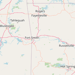
Map view of Winding Stair Mountain National Recreation Area

Use this park location map to pinpoint Winding Stair Mountain National Recreation Area in United States of America, understand its exact geographic position, and read its mapped placement within the surrounding landscape more clearly.

Pigeon | © OpenStreetMap contributors

Location context for Winding Stair Mountain National Recreation Area

Oklahoma
Park atlas

Compare surrounding protected landscapes and regional mountain terrain

Explore Parks Near Winding Stair Mountain National Recreation Area

Browse other parks and protected areas situated within the broader Ouachita mountain ecosystem. Compare nearby forest reserves and adjacent wilderness zones to understand the wider regional geography.
Watercolor painting of a forested landscape with soft rolling mountains in the background and vegetation in the foreground.
Protected landscapeArkansas
Mapped location lies within the park boundary#1 closest

Southeast

Ouachita National Forest: Protected Landscape and Mountain Geography in Arkansas

Exploring the ancient ridges and river corridors of the Ouachita Mountains

Ouachita National Forest protects a unique geological system of east-west folded ridges and sandstone bluffs in the interior United States. This expansive region provides vital habitats for diverse hardwood communities and hosts extensive wilderness areas, offering a deep look into the natural history and terrain of the Ouachita Mountain range within Arkansas.

Area
7,221.44 km²
Established
1907
IUCN
VI
Relief
Mountain
Protected landscapeArkansas
About 65 km away#2 closest

Northeast

Ozark, St. Francis National Forest: Geographic Overview of Arkansas Protected Wilderness Areas

Mapping rugged mountain slopes and Mississippi River floodplains.

This geographic profile of Ozark, St. Francis National Forest details the distinct ecological divide between the northern Ozark Mountain units and the eastern St. Francis ridge landscape. Use this data to trace the boundaries of old-growth pine stands, karst topography, and river-bottom habitats within one of Arkansas's most significant federal forest management systems.

Area
4,693.55 km²
Established
1908
Relief
Mountain
Climate
Temperate
Protected areaTexas
About 146 km away#3 closest

Southwest

Caddo National Grassland: Geographic Overview of a Texas Protected Area

Restored prairie and oak savanna in Fannin County

Located in northeastern Texas, Caddo National Grassland encompasses roughly 17,873 acres across two distinct units. The park illustrates a successful shift from eroded agricultural land to a protected mosaic of native grasses, hardwood stands, and aquatic corridors anchored by Lake Davy Crockett, providing a clear window into the recovery of the southern Great Plains.

Area
72.33 km²
Established
1930
Relief
Lowland
Climate
Temperate
National parkGarland County
About 156 km away#4 closest

East

Hot Springs National Park: National Park Protected Area and Geographic Context

Mapped boundaries and regional landscape of this US National Park.

Gain a structured understanding of Hot Springs National Park, focusing on its identity as a protected national park. Examine its mapped geography and regional landscape context within Garland County, providing essential details for atlas-based exploration. This entry details the park's protected area and its position in the broader geographic framework.

Area
22.5 km²
Established
1832
IUCN
II
Visitors
2.6M annual
A horizontal watercolor painting showing rolling green hills and a small stream in the foreground with faint mountain ridges in the distance.
Wildlife reserveArkansas
About 160 km away#5 closest

East

Flatside Wilderness: Rugged Sandstone Ridges in the Ouachita Mountains

Arkansas wildlife reserve featuring mountain summits and mapped backcountry

Flatside Wilderness offers a deep look at the high-relief geography of the Ouachita Mountains. Featuring prominent sandstone summits and an 8.9-mile segment of the Ouachita National Recreation Trail, this protected landscape provides essential insight into the state's wilderness systems and regional forest ecosystems.

Area
38.47 km²
Established
1984
IUCN
Ib
A soft watercolor illustration featuring a winding river flowing through a green valley with rolling hills in the background, accented by abstract pink blossoms or light reflections.
Wildlife reserveArkansas
About 176 km away#6 closest

Northeast

Richland Creek Wilderness: Mapping Protected Landscapes in the Arkansas Ozarks

A rugged wilderness area and wildlife reserve

Discover the topography and conservation value of Richland Creek Wilderness. This protected area in the Arkansas Ozarks features a complex network of forested hollows, steep sandstone bluffs, and clear creek corridors, offering an essential look at the region's preserved wilderness character and ecological landscape.

Area
48 km²
Established
1984
IUCN
Ib
Relief
Upland
Watercolor painting of a flowing river with a small waterfall and forested banks against a soft, hilly background.
National parkOklahoma
About 202 km away#7 closest

West

Chickasaw National Recreation Area: Geography and Protected Land Map Overview

Explore spring-fed creek corridors and reservoir landscapes in Oklahoma.

Understand the dual landscape of Chickasaw National Recreation Area, where narrow, spring-fed creek valleys contrast with the expansive shoreline of Lake of the Arbuckles. This record highlights the park's distinct transition from historic CCC-designed infrastructure to the surrounding prairie and forested hill terrain in Murray County.

Area
40.06 km²
Established
1902
Visitors
1.5M annual
Relief
Upland
National parkMissouri
About 210 km away#8 closest

Northeast

Mark Twain National Forest: Geography and Protected Area Atlas of Southern Missouri

Mapping the karst terrain and ancient ridges of the Ozark Highlands

Mark Twain National Forest represents a sprawling conservation area within the Missouri Ozark Highlands. Its geography is defined by volcanic mountain remnants, rocky glades, and significant river corridors like the Eleven Point National Scenic River. This record provides insight into the forest's complex mapped boundaries, seven designated wilderness areas, and the distinctive karst geology that characterizes this unique American landscape.

Area
6,037.3 km²
Established
1939
Relief
Upland
Climate
Temperate

Common questions about visiting, size, designation, and location context for Winding Stair Mountain National Recreation Area

Winding Stair Mountain National Recreation Area FAQs for park facts, access, geography, and protected area context

Find quick answers about Winding Stair Mountain National Recreation Area, including protected-area facts, park geography, trail and visitor context, and how the park fits into its surrounding country and regional landscape.
MoriAtlas Explorer

Continue Your Protected Areas Search Across the Global Atlas

Deepen your exploration by continuing the structured search for national parks and protected areas worldwide. Utilize the comprehensive filtering capabilities to compare different conservation landscapes and refine your understanding of global park geography. Discover more about the distribution and characteristics of protected natural areas.

Global natural geography