

Mori Atlas logo
National parkFlinders Chase National Park

Discover the mapped boundaries and regional geography of this key Australian national park.

Flinders Chase National Park: South Australia's Protected Landscape & Geographic Atlas Entry

Flinders Chase National Park stands as a protected national park entity, offering a focused point for geographic discovery within the landscape of South Australia. This page serves as an atlas entry, detailing the park's specific mapped boundaries and its role within the broader regional geography. Explore the foundational elements of this protected area to understand its place in the natural landscape context and contribute to a structured understanding of Australia's conservation territories.

National ParkSouth AustraliaKangaroo IslandCoastal LandscapeWildlife SanctuaryGeological Monuments

Flinders Chase National Park

National park

Park overview

Structured park overview, official facts, and landscape profile for Flinders Chase National Park

Flinders Chase National Park park facts, protected area profile, and essential visitor context
Review the core facts for Flinders Chase National Park, including designation, size, terrain, visitor scale, habitats, and operating context in one park-focused overview.

About Flinders Chase National Park

Flinders Chase National Park represents one of South Australia's most significant conservation areas, encompassing the rugged western wilderness of Kangaroo Island. The park's isolation from the Australian mainland has made it particularly valuable as a sanctuary for native species, as foxes and other predators that threaten wildlife on the continent are absent from the island. The park's three distinct sections each offer different landscapes: the coastal cliffs and blowholes around Cape du Couedic, the more interior woodlands of the Gosse Lands, and the former lighthouse reserve at Cape Borda. Beyond its ecological significance, the park protects geological features of national importance, with both Remarkable Rocks and Cape du Couedic recognized as geological monuments by the Geological Society of Australia. The park has faced significant fire events, including devastating burns in 2007 and 2019-20, the latter destroying the visitor center.

Quick facts and research context for Flinders Chase National Park

Flinders Chase National Park occupies the northwestern tip of Kangaroo Island, Australia's third-largest island. The park was the second national park established in South Australia and functions as a critical sanctuary for species introduced from the Australian mainland during the 1920s and 1930s, including koalas and platypus. The protected area contains three separate land parcels totaling over 326 square kilometers and is classified as an IUCN Category II protected area. The park is managed by the South Australian Department for Environment and Water.

Park context

Deeper park guide and search-rich context for Flinders Chase National Park

Flinders Chase National Park history, landscape, wildlife, and travel context
Explore Flinders Chase National Park through its history, landscape character, ecosystems, wildlife, conservation priorities, cultural context, and seasonal travel timing in a structured park guide built for atlas discovery and search intent.

Why Flinders Chase National Park stands out

Flinders Chase National Park is renowned for two spectacular geological monuments: the Remarkable Rocks, naturally sculptured granite formations precariously balanced atop a coastal outcrop, and the dramatic coastal landscapes around Cape du Couedic featuring Admirals Arch, a natural stone archway. The park is also famous as a sanctuary for endangered Australian wildlife, particularly koalas, platypus, and diverse bird species that have thrived in this predator-controlled environment away from the mainland.

Flinders Chase National Park history and protected-area timeline

The establishment of Flinders Chase traces to 1906 when a deputation of scientists lobbied South Australian Premier Tom Price to protect Kangaroo Island's wildlife. The government initially set aside the Cape Borda lighthouse reserve as a nature reserve in 1906, followed by conversion of additional pastoral land to nature reserve in 1909 under the Fauna and Flora Board. The reserve was named Flinders Chase at the suggestion of Samuel Dixon, chosen for its evocative connection to the island's coastal character. The park was formally declared as a flora and fauna reserve on 16 October 1919 under the Fauna and Flora Reserve Act 1919, specifically established to protect and propagate Australasian fauna and flora. By 1922, the reserve expanded to nearly 200 square miles through incorporation of the Rocky River freehold. The area was proclaimed as a national park on 27 April 1972 under the National Parks and Wildlife Act 1972, which repealed the earlier Fauna and Flora Reserve Act. In 1993, significant land was removed and redesignated as the Ravine des Casoars Wilderness Protection Area under the Wilderness Protection Act 1992.

Flinders Chase National Park landscape and geographic character

The landscape of Flinders Chase National Park is characterized by dramatic coastal scenery and inland woodland environments. The Cape du Couedic section features rugged cliffs, rocky shores, and the famous Admirals Arch, a natural rock formation carved by relentless ocean waves. The Remarkable Rocks are perched atop a granite dome in the southern part of the park, creating an otherworldly landscape of balanced boulders and sculptured rock forms. The Gosse Lands portion encompasses more vegetated terrain with woodland and heathland communities. The park also protects several offshore islands including Paisley Islet at West Bay and the Casuarina Islets near Cape du Couedic. The coastline ranges from sandy bays to rocky headlands, while the interior features rolling terrain and river systems including the Rocky River and De Mole River.

Flinders Chase National Park ecosystems, habitats, and plant life

Flinders Chase National Park protects diverse habitats that support significant biodiversity. The park's island setting and protection from mainland predators has allowed native species to flourish. The vegetation communities include coastal heath, woodland, and forest ecosystems adapted to Kangaroo Island's Mediterranean climate. The absence of foxes has been particularly crucial for ground-nesting birds and small mammals. The park's ecosystems support numerous species that have declined or disappeared from the Australian mainland due to predation and habitat loss. Wetland areas associated with the Rocky River and De Mole River provide habitat for aquatic species, while the coastal and island habitats support marine and seabird populations.

Flinders Chase National Park wildlife and species highlights

Flinders Chase functions as an important wildlife sanctuary, with many species introduced from the Australian mainland during the 1920s and 1930s now thriving in the protected environment. Koalas, introduced in 1923, are commonly observed throughout the park, often visible in eucalypt trees along roads and walking tracks. Platypus, introduced in 1928, inhabit the freshwater streams and rivers. Western grey kangaroos are abundant, often seen grazing in open areas, while goannas and echidnas are commonly encountered. The park supports diverse birdlife including species that have declined on the mainland. Historically, little penguins nested in the park during the 1920s through 1950s, though these colonies are believed to have since gone extinct, possibly due to increased long-nosed fur seal populations.

Flinders Chase National Park conservation status and protection priorities

As South Australia's second national park, Flinders Chase represents a landmark in Australian conservation history. The park was specifically established to provide a refuge for wildlife threatened on the Australian mainland, particularly from fox predation. The island's isolation from the mainland has enabled successful conservation of species that cannot survive in continental environments. The park contains geological monuments of national significance recognized by the Geological Society of Australia. Fire management remains a critical challenge, with major events in 2007 and 2019-20 significantly impacting the park's ecosystems. The park's IUCN Category II designation reflects its primary purpose of protecting natural ecosystems while allowing sustainable visitor access.

Flinders Chase National Park cultural meaning and human context

The cultural landscape of Flinders Chase reflects both Aboriginal connection to Kangaroo Island and more recent European settlement history. The park's name was chosen in 1919 by Samuel Dixon, reflecting the area's coastal character and the broader exploration heritage of the region. The former Cape Borda Lightstation reserve represents European maritime heritage, with the lighthouse having played a crucial role in guiding ships along the dangerous southern Australian coast. The park also encompasses land previously used for pastoral purposes before conversion to conservation protection, reflecting the broader historical pattern of land use change on Kangaroo Island.

Top sights and standout views in Flinders Chase National Park

Flinders Chase National Park offers exceptional natural attractions including the iconic Remarkable Rocks with their surreal balanced granite formations, Admirals Arch with its dramatic coastal rock arch, and the historic Cape Borda lighthouse. The park provides excellent wildlife viewing opportunities, particularly for koalas, kangaroos, echidnas, and platypus. The three-section park offers diverse experiences from coastal cliff landscapes to interior woodland environments. The Bunker Hill lookout provides panoramic views across the park's wilderness. Walking trails traverse the various landscapes, and the visitor center, rebuilt after the 2019-20 fires, serves as an interpretive hub for understanding the park's natural and cultural values.

Best time to visit Flinders Chase National Park

The best time to visit Flinders Chase National Park is during the Australian spring and summer months from October through March, when the weather is generally mild and clear. This period offers optimal conditions for exploring the park's outdoor attractions and wildlife viewing. Winter months (June to August) can bring wet and windy conditions, though the park remains accessible. Summer fires remain a risk, as demonstrated by past significant bushfire events. The shoulder seasons of spring and autumn provide pleasant temperatures and good wildlife viewing opportunities, with wildflower displays in spring adding to the park's appeal. Visitors should check current conditions and any fire advisories before planning trips.
Park location guide

Geography guide, regional context, and park location map for Flinders Chase National Park

Flinders Chase National Park park geography, regions, and map view in Australia
Understand where Flinders Chase National Park sits in Australia through a broader geographic reading of the surrounding landscape, nearby location context, and its mapped position within the national park landscape.

How Flinders Chase National Park fits into Australia

Australia is a constitutional monarchy and federal parliamentary democracy comprising six states and ten territories. With a population of nearly 28 million, it is one of the world's most urbanised countries, with most people concentrated on the eastern seaboard. The country has a high Human Development Index and is known for its cultural diversity, ancient Aboriginal heritage, and unique wildlife.

Wider geography shaping Flinders Chase National Park in Australia

Australia occupies the entire Australian continent, the island of Tasmania, and numerous smaller islands. It is the world's flattest and driest inhabited continent, featuring vast deserts in the interior (the Outback), tropical rainforests along the eastern coast, and a coastline bordering the Indian and Pacific Oceans.

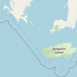
Map view of Flinders Chase National Park

Use this park location map to pinpoint Flinders Chase National Park in Australia, understand its exact geographic position, and read its mapped placement within the surrounding landscape more clearly.

Pigeon | © OpenStreetMap contributors

Location context for Flinders Chase National Park

Kangaroo IslandSouth Australia
Park atlas

Compare diverse protected landscapes, coastal habitats, and wildlife sanctuaries across Kangaroo Island and South Australia.

Discover Related National Parks and Protected Areas Near Flinders Chase National Park on Kangaroo Island
Browse national parks and protected areas geographically connected to Flinders Chase National Park, extending your exploration across Kangaroo Island's diverse coastal and inland environments. Compare adjacent conservation landscapes and regional park features, tracing protected terrain and wildlife sanctuaries within South Australia's broader atlas.
National parkSouth Australia

Lincoln National Park National Park: Mapped Protected Area and Geographic Landscape Identity

South Australia's protected landscape with detailed park boundaries.

Gain a comprehensive atlas perspective on Lincoln National Park, a designated national park in South Australia. This resource details the park's mapped boundaries, offering clear geographic context and highlighting its role as a protected landscape. Understand its place within the regional geography of South Australia, providing essential data for landscape exploration and atlas-based research.

Area
216.38 km²
Established
1941
IUCN
II
Relief
Upland
National parkSouth Australia

Deep Creek National Park: Protected Coastal Terrain and Geographic Context in South Australia

Discover South Australia's largest remaining natural vegetation area.

Deep Creek National Park offers a unique protected landscape on South Australia's Fleurieu Peninsula, extending 18 kilometers along the rugged coast. This national park is renowned for its rolling hills, gullies, and dramatic views across Backstairs Passage to Kangaroo Island. It serves as a crucial conservation area, preserving the largest continuous segment of natural vegetation in a region largely transformed by development, making its geography and protected status highly significant.

Area
44.96 km²
Established
1971
IUCN
II
Relief
Mixed relief
National parkSouth Australia

Coffin Bay National Park: Protected Landscape and Geographic Context in South Australia

Explore the mapped boundaries and regional geography of this national park.

Coffin Bay National Park presents a distinct protected landscape within South Australia, offering a valuable point of entry for geographic discovery. This page details the park's national park designation and its mapped territory, crucial for understanding its role in Australia's atlas of natural areas. Delve into the park's specific geographic context and the outlines of its protected lands, providing a clear picture of its landscape within the state's broader terrain.

Area
309.76 km²
Established
1982
IUCN
II
Relief
Lowland
National parkSouth Australia

Onkaparinga River National Park: National Park Protected Landscape in South Australia

Explore mapped boundaries and regional geographic context.

Onkaparinga River National Park is a designated national park within South Australia, offering a focused point for understanding protected landscapes. This entry provides detailed geographic context, highlighting the park's mapped boundaries and its place within the regional atlas. Engage with the specific geography and protected-area identity of Onkaparinga River National Park to enhance your landscape exploration.

Area
15.42 km²
Established
1993
IUCN
II
Relief
Upland
National parkSouth Australia

Belair National Park National Park: South Australia Protected Landscape and Map Exploration

Explore the geographic context and mapped boundaries of this South Australian protected area.

Belair National Park represents a significant protected land entity within South Australia, offering specific geographic insights relevant to atlas exploration. As a designated national park, its mapped boundaries and landscape character are essential for understanding regional conservation efforts. This profile provides foundational information on the park's identity as a protected natural area, anchoring its position within the geography of South Australia for detailed map-based discovery and regional context.

Area
8.35 km²
Established
1891
IUCN
II
Visitors
358.6K annual
National parkAdelaide Hills

Cleland National Park: Mapped Protected Landscape and Regional Geographic Context

Discover the natural terrain and park boundaries within Adelaide Hills.

Cleland National Park offers a critical lens into the protected landscapes of South Australia's Adelaide Hills. As a national park, its mapped boundaries and geographic position are key elements for understanding regional natural terrain. This resource facilitates atlas-style exploration of Cleland National Park, highlighting its importance within the conservation framework and providing a foundation for detailed geographic study.

Area
11.25 km²
Established
1945
IUCN
II
Visitors
100K annual
National parkSouth Australia

Coorong National Park: South Australia National Park Mapped Boundaries and Landscape Context

Explore its unique protected landscape and regional geography.

Coorong National Park in South Australia is featured here as a key protected area for geographic discovery. Users can explore the park's specific landscape characteristics, mapped boundaries, and its role within the regional geography of South Australia. This detail page supports an atlas-based understanding of protected lands, offering a focused perspective on the park's natural terrain and conservation significance within Australia.

Area
490.15 km²
Established
1967
IUCN
II
Relief
Lowland
National parkSouth Australia

Wapma Thura, Southern Flinders Ranges National Park: South Australia's Protected Natural Landscape

Explore mapped boundaries and regional geography.

Wapma Thura, Southern Flinders Ranges National Park offers a distinct protected landscape within South Australia. This page serves as a portal for understanding its geographic setting, its role as a national park, and its place within the state's atlas of natural areas. Examine the mapped terrain and protected boundaries to grasp the park's unique geographic characteristics.

Established
2021
IUCN
II
Relief
Mountain
Scope
Terrestrial

Common questions about visiting, size, designation, and location context for Flinders Chase National Park

Flinders Chase National Park FAQs for park facts, access, geography, and protected area context
Find quick answers about Flinders Chase National Park, including protected-area facts, park geography, trail and visitor context, and how the park fits into its surrounding country and regional landscape.
MoriAtlas Explorer

Continue Your Protected Areas Search Across the Global Atlas

Deepen your exploration by continuing the structured search for national parks and protected areas worldwide. Utilize the comprehensive filtering capabilities to compare different conservation landscapes and refine your understanding of global park geography. Discover more about the distribution and characteristics of protected natural areas.

Global natural geography