


Mori Atlas logo
Marine protected areaGreat Australian Bight Marine Park

Examining the complex geography of coastal waters and offshore continental shelf zones

Great Australian Bight Marine Park: A Tiered Marine Protected Area in South Australia

The Great Australian Bight Marine Park represents an expansive conservation landscape that links state coastal waters with offshore commonwealth reserves. This complex marine environment encompasses dramatic cliff-backed shorelines and nutrient-rich zones of the Southern Ocean. Explore the geographic distribution and layered jurisdictional boundaries that define this significant marine habitat within the Australian Exclusive Economic Zone.

marine protected areagreat australian bightwhale sanctuarysouth australiaaustralian exclusive economic zonecommonwealth marine reserve
Stylized digital illustration of steep layered coastal cliffs meeting the ocean at sunset with pastel colors.

Great Australian Bight Marine Park

Marine protected area

Park overview

Structured park overview, official facts, and landscape profile for Great Australian Bight Marine Park

Great Australian Bight Marine Park park facts, protected area profile, and essential visitor context

Review the core facts for Great Australian Bight Marine Park, including designation, size, terrain, visitor scale, habitats, and operating context in one park-focused overview.

About Great Australian Bight Marine Park

Great Australian Bight Marine Park represents a coordinated approach to conserving one of Australia's most distinctive marine regions, where the continent's dry southern edge descends into a wide, open oceanic bight. The park is not a single contiguous reserve but rather a collective designation for several marine protected areas that together address different parts of this environment, from coastal waters under South Australian jurisdiction to deeper offshore waters under commonwealth jurisdiction.

Within South Australia's coastal waters, the Great Australian Bight Marine National Park and the Great Australian Bight Marine Park Whale Sanctuary provide targeted protection for nearshore marine habitats and, in the case of the whale sanctuary, a specific focus on the migratory cetaceans that pass through these waters. Beyond the state-controlled zone, the Great Australian Bight Commonwealth Marine Reserve extends the protection footprint into the wider Exclusive Economic Zone, supporting conservation of offshore marine ecosystems and broader biodiversity.

The umbrella park identity, in use by at least 2005, allows these overlapping jurisdictions and protection categories to be understood as part of one conservation system. The park's listing on the former Register of the National Estate also highlights its recognized heritage status, an important indicator that its values were formally acknowledged at a national level even before the expansion of Australia's modern marine park network. Today, the Great Australian Bight Marine Park remains an important reference point for understanding how layered marine protection works along Australia's remote southern coastline.

Quick facts and research context for Great Australian Bight Marine Park

Great Australian Bight Marine Park is a grouped marine protected area located along the southern margin of Australia, spanning both South Australian state coastal waters and a larger zone within the Australian Exclusive Economic Zone. Its constituent protected areas include the Great Australian Bight Marine National Park, the Great Australian Bight Marine Park Whale Sanctuary, and the Great Australian Bight Commonwealth Marine Reserve. The combined arrangement has been referenced in conservation records since at least 2005 and was recognized on Australia's former Register of the National Estate.

Protection and recognition

Examine documented marine protection status and international designation records.

Great Australian Bight Marine Park Protection Status and Recognition

Marine protection status and management scope details are compiled for Great Australian Bight Marine Park. Official designation records provide structured insight into administrative frameworks and international recognition status.

Protection details

Protection scope
Marine
Transboundary protection
No
Park context

Deeper park guide and search-rich context for Great Australian Bight Marine Park

Great Australian Bight Marine Park history, landscape, wildlife, and travel context

Explore Great Australian Bight Marine Park through its history, landscape character, ecosystems, wildlife, conservation priorities, cultural context, and seasonal travel timing in a structured park guide built for atlas discovery and search intent.

Why Great Australian Bight Marine Park stands out

The park is best known for protecting a significant stretch of the Great Australian Bight's marine environment, including waters widely associated with southern right whales and other cetaceans. Its layered structure connects nearshore South Australian protections, a dedicated whale sanctuary, and a broader commonwealth marine reserve further offshore, giving the Bight a tiered framework of conservation coverage. The region's identity is closely tied to the dramatic meeting of arid southern coastline with the cool, productive waters of the Southern Ocean.
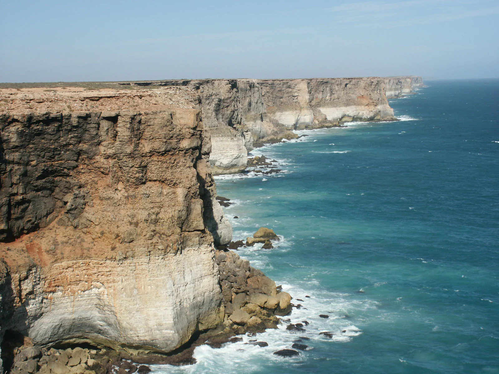
A wide angle view of the rugged, steep Bunda Cliffs dropping into the turquoise water of the ocean, with the coastline stretching into the distance.
The Bunda Cliffs along the coastline of the Great Australian Bight Marine Park.

Great Australian Bight Marine Park landscape and geographic character

The broader landscape setting of the Great Australian Bight Marine Park is defined by the bight itself: a sweeping curvature of Australia's southern coastline where arid, often cliff-backed land meets a vast, open marine environment. The supporting terrestrial backdrop includes long stretches of remote, sparsely populated southern Australian shore, characterized by elevated cliffs, low coastal ranges, and exposed escarpments that drop steeply toward the sea.

Below the waterline, the marine landscape features a continental shelf environment that extends offshore before deepening into the bight's oceanic waters. The interaction between cold, nutrient-rich Southern Ocean currents and the continental shelf is central to the productivity of these waters and shapes both the marine habitats and the marine life that the park helps protect. While most public attention focuses on the visible coastline, the park's offshore zones cover a far broader and more varied seascape than the shoreline alone would suggest.

Great Australian Bight Marine Park ecosystems, habitats, and plant life

The marine environment encompassed by the Great Australian Bight Marine Park reflects the transition between coastal and deep-water systems typical of Australia's southern continental margin. Nearshore waters close to South Australia support a range of temperate marine habitats, including areas of subtidal reef, shelf sediments, and waters influenced by the Southern Ocean's seasonal productivity cycles.

Further offshore, within the commonwealth marine reserve component, the environment shifts toward more open-ocean conditions across a broader portion of the continental shelf and surrounding waters. This combination of coastal and pelagic habitats gives the broader protected area network an unusually diverse ecological profile, supporting species whose life cycles depend both on shallow coastal environments and on the more open waters beyond. The bight's waters are also influenced by upwelling and current patterns that contribute to its biological richness.

Great Australian Bight Marine Park wildlife and species highlights

The Great Australian Bight has long been recognized for its cetacean activity, and the marine park network reflects this through the inclusion of the Great Australian Bight Marine Park Whale Sanctuary. Southern waters in this region are associated with the seasonal movements of southern right whales, while the broader marine environment supports other cetaceans and a wide range of marine fauna typical of Australia's southern shelf and continental slope ecosystems.

The nutrient-rich waters of the bight sustain diverse fish, invertebrate, and seabird communities, with the offshore reserve component providing protection for species and habitats that depend on less disturbed open-ocean conditions. The park's combination of a coastal whale-focused sanctuary and a broader offshore commonwealth reserve allows different wildlife priorities to be addressed within a single coordinated framework.

Great Australian Bight Marine Park conservation status and protection priorities

Great Australian Bight Marine Park illustrates how Australian marine conservation is often delivered through layered, complementary protection mechanisms rather than single large reserves. By linking a South Australian marine national park, a dedicated whale sanctuary, and a commonwealth marine reserve stretching beyond state waters, the park covers coastal, mid-shelf, and offshore environments at appropriate levels of protection.

Inclusion on Australia's former Register of the National Estate marked the broader protected area as having recognized heritage and ecological values at a national level, underscoring the significance of the bight's marine environment beyond its immediate jurisdictions. From a conservation standpoint, the park matters not only for the specific habitats and species it protects, but also as an example of coordinated cross-jurisdictional marine management along a remote and ecologically important section of Australia's coastline.

Top sights and standout views in Great Australian Bight Marine Park

The park's strongest distinguishing features include its segment of one of Australia's most iconic stretches of southern coastline and its tiered protection framework. The presence of a dedicated whale sanctuary alongside a broader commonwealth marine reserve highlights the specific conservation priority given to cetaceans in these waters, an emphasis that aligns with the long-running recognition of the bight as an important whale habitat.

Equally notable is the scale of the marine park beyond the shoreline, extending protections far into offshore waters within the Australian Exclusive Economic Zone. This combination of dramatic coastal scenery, recognized whale significance, and substantial offshore coverage gives Great Australian Bight Marine Park a multi-layered conservation identity.

Best time to visit Great Australian Bight Marine Park

Seasonal character in the Great Australian Bight is shaped largely by its southern exposure and its marine life cycles. The cooler months are widely associated with whale activity along this stretch of coast, including the movement of southern right whales through regional waters, which has historically drawn attention to the area. Warmer months typically bring calmer sea conditions and broader accessibility for coastal viewing, while also marking a different phase of marine productivity influenced by Southern Ocean conditions.
Monthly climate preview

Long-term monthly temperature averages and precipitation records for South Australia

Great Australian Bight Marine Park Climate Normals and Annual Weather Patterns

Representative coordinate records show measured monthly temperature ranges and precipitation rates spanning twelve distinct periods across the marine protected landscape. Detailed monthly averages provide deeper context on long-term climate normals for the designated marine boundary.
Annual mean18 °C
13 °C22 °C
Jan22°
Feb22°
Mar21°
Apr19°
May17°
Jun14°
Jul13°
Aug14°
Sep16°
Oct17°
Nov19°
Dec21°
Warmest month
February

21.9 °C

Coolest month
July

13.3 °C

Wettest month
June

1 mm/day

Driest month
October

0.5 mm/day

Park location guide

Geography guide, regional context, and park location map for Great Australian Bight Marine Park

Great Australian Bight Marine Park park geography, regions, and map view in Australia

Understand where Great Australian Bight Marine Park sits in Australia through a broader geographic reading of the surrounding landscape, nearby location context, and its mapped position within the national park landscape.

How Great Australian Bight Marine Park fits into Australia

Australia is a constitutional monarchy and federal parliamentary democracy comprising six states and ten territories. With a population of nearly 28 million, it is one of the world's most urbanised countries, with most people concentrated on the eastern seaboard. The country has a high Human Development Index and is known for its cultural diversity, ancient Aboriginal heritage, and unique wildlife.

Wider geography shaping Great Australian Bight Marine Park in Australia

Australia occupies the entire Australian continent, the island of Tasmania, and numerous smaller islands. It is the world's flattest and driest inhabited continent, featuring vast deserts in the interior (the Outback), tropical rainforests along the eastern coast, and a coastline bordering the Indian and Pacific Oceans.

Map view of Great Australian Bight Marine Park

Use this park location map to pinpoint Great Australian Bight Marine Park in Australia, understand its exact geographic position, and read its mapped placement within the surrounding landscape more clearly.

Pigeon | © OpenStreetMap contributors

Location context for Great Australian Bight Marine Park

South Australia

Visual reference collection for coastal cliffs and marine habitats

Great Australian Bight Marine Park Landscape and Scenery Photography

Visual records illustrate the rugged coastal cliffs, remote southern Australian shorelines, and expansive open waters that define the protected environment. Reviewing these detailed field images provides a clearer understanding of the varied topography and marine habitats preserved across the marine reserve network.

A wide angle view of the rugged, steep Bunda Cliffs dropping into the turquoise water of the ocean, with the coastline stretching into the distance.

Park atlas

Compare nearby marine protected areas and surrounding southern coastal landscapes

Other Parks Near Great Australian Bight Marine Park and Related Coastal Reserves

Browse protected areas and marine reserves adjacent to Great Australian Bight Marine Park along the southern Australian coastline. Continuing the comparison reveals broader regional conservation frameworks and offshore ecosystems across the Southern Ocean.
Marine protected areaSouth Australia
Mapped location lies within the park boundary#1 closest

East

Great Australian Bight Marine National Park: Marine Protected Area Atlas and Geographic Context

Mapping the protected marine landscape of South Australia.

Delve into the geography and mapped boundaries of Great Australian Bight Marine National Park, a critical marine protected area located off the coast of South Australia. This resource provides an atlas-style view of the park, highlighting its geographic setting and significance as a protected marine environment. Understand the scope of this marine protected area and its place within the Australian geography, offering rich context for discovery and map exploration.

Area
1,233.22 km²
Established
1996
IUCN
II
Access
Access unknown
National parkSouth Australia
About 24 km away#2 closest

North

Nullarbor National Park: Mapped Boundaries and Geographic Context in South Australia

Explore the protected landscape and terrain of this South Australian national park.

Nullarbor National Park is a key protected area offering valuable insights into Australia's natural landscapes. This page facilitates a detailed atlas-style exploration of the park's geographic setting and mapped boundaries within South Australia, highlighting its role as a national park and a component of regional conservation efforts.

Area
323.1 km²
Established
1979
IUCN
VI
Relief
Lowland
National parkWestern Australia
About 106 km away#3 closest

West

Eucla National Park: Remote Coastal Protected Landscape in Western Australia

Explore limestone cliffs, sand dunes, and historic sites.

Eucla National Park showcases the dramatic interface of the Great Australian Bight with Western Australia's coastline. This protected area features striking limestone cliffs, vast migrating sand dune systems like the Delisser sandhills, and undulating mallee scrub. Discover the atmospheric ruins of the historic Eucla Telegraph Station, partially engulfed by dunes, and understand the unique geographic context and protected landscape identity of this remote national park.

Area
35.6 km²
IUCN
II
Access
Remote access
Water
Major water bodies
Nature reserveSouth Australia
About 213 km away#4 closest

East

Fowlers Bay Conservation Park: Coastal Protected Area and Regional Geography

A remote conservation landscape on the Great Australian Bight

Fowlers Bay Conservation Park stands as a vital protected area in South Australia, where vertical limestone cliffs meet horizontal chenopod plains. The park provides an essential look at the interaction between Southern Ocean maritime forces and the arid western Eyre Peninsula, offering a rare window into the transition zones of the Great Australian Bight coast.

Area
87.27 km²
Established
1993
IUCN
VI
Relief
Lowland
Nature reserveSouth Australia
About 234 km away#5 closest

East

Boondina Conservation Park: Protected Landscapes and Regional Geography in South Australia

A remote nature reserve within the Yellabinna mallee woodland network.

Boondina Conservation Park is a 125 square kilometre nature reserve in far western South Australia. It forms part of the expansive Yellabinna Reserves, buffering semi-arid mallee woodland environments and supporting regional ecological processes. This IUCN Category VI area stands out for its co-management with the Far West Coast Aboriginal Corporation and its role as a preserved natural landscape where traditional land use continues.

Area
125.55 km²
Established
1993
IUCN
VI
Relief
Lowland
Nature reserveSouth Australia
About 250 km away#6 closest

East

Chadinga Conservation Park: Coastal Dunes and Salt Lake Geography in South Australia

Remote protected dune systems and arid saline landscapes

Chadinga Conservation Park protects a significant stretch of coastal dune country west of Lake MacDonnell. This arid landscape, defined by salt lakes and mallee scrub, serves as a crucial habitat for rare species, offering a raw and undisturbed look at the coastal geography of the South Australian coastline.

Area
118.54 km²
Established
1993
IUCN
VI
Relief
Lowland
Marine protected areaSouth Australia
About 259 km away#7 closest

Southeast

Murat Marine Park: Geography and Protected Marine Landscape of South Australia

Marine protected area atlas and bathymetric overview

Murat Marine Park represents an offshore sanctuary within the Great Australian Bight. This marine protected area features a blend of sediment-dominated shelf habitats and the submerged Yatala Reef, providing essential feeding grounds for diverse marine life. Explore the mapped territory and understand its placement within the wider South-west Marine Parks Network through a geographic and atlas-focused lens.

Area
937.77 km²
Established
2012
IUCN
II
Relief
Lowland
Watercolor painting of a serene landscape showing rolling green hills and a lake or pond under a soft light.
Nature reserveSouth Australia
About 287 km away#8 closest

North

Mamungari Conservation Park: Arid Landscapes and Protected Areas in South Australia

Mapping desert ecosystems and expansive wilderness boundaries

Spanning 21,000 square kilometres of the Great Victoria Desert and the northern Nullarbor Plain, Mamungari Conservation Park is a major nature reserve. The mapped terrain features striking salt lakes, sandplains, and dune ridges, providing a clear window into the remote geography of South Australia's arid interior.

Area
21,289.4 km²
Established
1970
IUCN
Ia
Relief
Lowland

Common questions about visiting, size, designation, and location context for Great Australian Bight Marine Park

Great Australian Bight Marine Park FAQs for park facts, access, geography, and protected area context

Find quick answers about Great Australian Bight Marine Park, including protected-area facts, park geography, trail and visitor context, and how the park fits into its surrounding country and regional landscape.
MoriAtlas Explorer

Continue Your Protected Areas Search Across the Global Atlas

Deepen your exploration by continuing the structured search for national parks and protected areas worldwide. Utilize the comprehensive filtering capabilities to compare different conservation landscapes and refine your understanding of global park geography. Discover more about the distribution and characteristics of protected natural areas.

Global natural geography