Mori Atlas logo
National parkNullarbor National Park

Mapping the protected boundaries and natural terrain of this significant Australian national park.

Nullarbor National Park: Protected Landscape Atlas and Geographic Context in South Australia

Nullarbor National Park represents a crucial protected area within the vast geographic expanse of South Australia. This entry provides detailed map-based exploration of its boundaries and landscape context, offering insights into its regional significance as a national park. Discover the mapped terrain and the park's place within the broader South Australian geography for a structured understanding of this protected natural landscape.

arid landscapelimestone plainsemi-arid rangelandSouth Australian parksflat terraindesert ecosystems

Nullarbor National Park

National park

Park overview

Structured park overview, official facts, and landscape profile for Nullarbor National Park

Nullarbor National Park park facts, protected area profile, and essential visitor context
Review the core facts for Nullarbor National Park, including designation, size, terrain, visitor scale, habitats, and operating context in one park-focused overview.

About Nullarbor National Park

Nullarbor National Park protects a significant portion of Australia's southern arid zone, specifically the eastern sector of the Nullarbor Plain that extends across the border regions of South Australia and Western Australia. The Nullarbor Plain itself is an enormous karst landscape formed from ancient marine sediments that were uplifted and subsequently eroded, leaving behind an extraordinarily flat surface dominated by limestone. The park's terrain is remarkably uniform, with minimal relief across its expanse, creating a landscape that appears almost infinite when viewed from any elevated position. The underlying limestone geology influences the surface conditions, with shallow soils supporting sparse vegetation communities adapted to the region's arid climate. The area experiences low rainfall and high temperatures, with evaporation rates far exceeding precipitation throughout most of the year. This extreme aridity shapes every aspect of the landscape, from the types of plants that survive to the absence of permanent surface water bodies. The park forms part of a larger conservation mosaic that includes the Nullarbor Wilderness Protection Area and the Nullarbor Regional Reserve, creating a contiguous protected zone that extends across the semi-arid rangelands of the region.

Quick facts and research context for Nullarbor National Park

Nullarbor National Park occupies a portion of the Nullarbor Plain in far-western South Australia, near the Western Australian border. The park was established on 31 May 1979 and was significantly reduced in size in 2013 when the Nullarbor Wilderness Protection Area was proclaimed, leaving the current footprint of 323.10 square kilometers. The area is classified under IUCN Category VI, denoting a protected area with sustainable use of natural resources. The park is bounded to the west by the state border with Western Australia, to the north by the Nullarbor Regional Reserve, and to the east and south by the Nullarbor Wilderness Protection Area. The governing body is the South Australian Department for Environment and Water.

Park context

Deeper park guide and search-rich context for Nullarbor National Park

Nullarbor National Park history, landscape, wildlife, and travel context
Explore Nullarbor National Park through its history, landscape character, ecosystems, wildlife, conservation priorities, cultural context, and seasonal travel timing in a structured park guide built for atlas discovery and search intent.

Why Nullarbor National Park stands out

Nullarbor National Park is best known for its representation of the Nullarbor Plain, one of the world's largest and most uniform limestone plains. The park protects a landscape of extraordinary flatness and geological simplicity, where the ancient Tertiary-era limestone bedrock lies near the surface, creating a near-panoramic horizon across the treeless expanse. This is a landscape defined by absence rather than presence: absence of trees, absence of prominent topographic variation, and absence of surface water drainage patterns. The region represents an extreme of Australian arid-zone geography and serves as a reference site for understanding the formation and evolution of Australia's southern coastal desert environments.

Nullarbor National Park history and protected-area timeline

Nullarbor National Park was established on 31 May 1979 as part of South Australia's protected area expansion during the late 1970s and 1980s. At its founding, the park encompassed a substantially larger area of approximately 5,781 square kilometers, reflecting a period when the state was creating large conservation reserves to protect extensive arid-zone landscapes. However, in 2013, the park's boundaries were significantly revised as part of the proclamation of the Nullarbor Wilderness Protection Area. This reorganization reduced the park's extent to its current 323.10 square kilometers, with the former park area now incorporated into the wilderness protection area to the east and south. The 1980 listing of the area on the now-defunct Register of the National Estate provided formal recognition of its national significance, though this register has since been superseded by other heritage listing mechanisms.

Nullarbor National Park landscape and geographic character

The landscape of Nullarbor National Park is defined by its extraordinary flatness and geological simplicity. The Nullarbor Plain represents one of the world's most extensive and level limestone plains, formed from marine sediments deposited during the Tertiary period and subsequently uplifted above sea level. The underlying limestone bedrock lies close to the surface throughout much of the park, with only thin soils and sparse cover masking the solid geology below. The surface displays classic karst features including shallow sinkholes and subtle depressions that evidence the slow dissolution of the limestone by groundwater. The vegetation is minimal and scattered, consisting primarily of low-growing shrubs and grasses adapted to the shallow, alkaline soils. There are no prominent hills, mountains, or dramatic terrain features to break the visual continuity of the plain, creating an almost surreal sense of horizontal expanse. The absence of trees, from which the region derives its name from the Latin "nullus arbor," is a defining characteristic of the landscape.

Nullarbor National Park ecosystems, habitats, and plant life

The ecological character of Nullarbor National Park reflects extreme arid-zone conditions with correspondingly limited biodiversity and productivity. The vegetation consists of sparse shrubland and grassland communities dominated by species adapted to drought, high alkalinity, and shallow soils. Bluebush and saltbush species are characteristic of the region's more fertile areas, while sandhill canegrass and various ephemeral herbs appear after rainfall events. The park lies within the larger Nullarbor Bioregion, recognized for its distinctive assemblages of plants and animals that have evolved specifically to cope with the harsh environmental conditions. The region's geological stability and ancient land surface have allowed for the development of specialized endemic species, though the extreme conditions limit overall species diversity. Soils are predominantly calcareous, derived from the weathered limestone substrate, and support distinctive plant communities that differ from the sandy desert systems found elsewhere in arid Australia.

Nullarbor National Park wildlife and species highlights

The wildlife of Nullarbor National Park reflects the harsh arid conditions of the region, with species diversity limited but with notable adaptations to the extreme environment. Reptiles form a significant component of the park's vertebrate fauna, with various skinks, geckos, and snakes adapted to the desert conditions. Birdlife includes species typical of arid rangelands, with emus and various ground-dwelling birds such as the malleefowl occurring in the area. Smaller mammals including several rodent species and the common dunnart are present, utilizing the sparse ground cover for shelter and foraging. The park lies within the range of the endangered Australia's southern hairy-nosed wombat, though this species is more commonly associated with the more vegetated portions of the Nullarbor region. The extreme aridity and lack of surface water mean that wildlife concentrations are generally low and dispersed across the landscape, with animal activity often concentrated around the limited available resources.

Nullarbor National Park conservation status and protection priorities

Nullarbor National Park contributes to the protection of one of Australia's most distinctive and scientifically significant arid landscapes. The park forms part of a connected conservation network that includes the Nullarbor Wilderness Protection Area and Nullarbor Regional Reserve, creating a substantial protected corridor across the semi-arid rangelands of the border region. The protection of this landscape preserves representative examples of the Nullarbor Plain's unique geological and ecological character, which would otherwise be subject to pastoral use and potential degradation. The IUCN Category VI classification reflects the park's approach to balancing conservation with sustainable natural resource use, appropriate to the region's extensive pastoral history. The area's scientific value includes its geological significance as one of the world's largest and most intact limestone plains, as well as its role in understanding Australia's arid-zone ecology and evolutionary processes.

Nullarbor National Park cultural meaning and human context

The Nullarbor region has been home to Indigenous peoples for tens of thousands of years, with the park lying within the traditional Country of the Wirangu and other Aboriginal groups. The ancient and stable landscape of the Nullarbor Plain contains archaeological evidence of Aboriginal occupation, including rock shelter sites with evidence of continued use over millennia. These sites provide insights into the cultural significance of the landscape to Indigenous Australians and the ways in which Aboriginal people adapted to and utilized the extreme arid environment. The traditional Indigenous relationship with the Nullarbor landscape reflects a deep knowledge of the region's resources, seasonal patterns, and ecological processes, developed over countless generations of occupation.

Top sights and standout views in Nullarbor National Park

The defining highlight of Nullarbor National Park is the opportunity to experience one of Australia's most geographically unique landscapes: a vast, almost perfectly flat plain stretching to the horizon under an enormous sky. The sense of isolation and emptiness that defines the Nullarbor offers a distinctive kind of wilderness experience, far removed from the mountainous or forested landscapes that characterize many other Australian parks. The geological simplicity of the limestone plain provides a rare opportunity to observe fundamental earth processes and landform evolution in an uncluttered, comprehensible scale. The night sky over the Nullarbor is exceptionally dark and clear, offering extraordinary astronomical viewing opportunities away from any light pollution.

Best time to visit Nullarbor National Park

The Nullarbor region is best visited during the cooler months of autumn and spring, when daytime temperatures are more comfortable for outdoor exploration. Summer temperatures can be extremely high, often exceeding 40 degrees Celsius, making outdoor activity potentially dangerous and impractical. Winter brings cooler conditions but may include occasional cold fronts and rain events that can affect access and conditions. The park can be visited year-round, though the experience varies significantly with the seasons. Spring and early summer may bring brief wildflower displays following rainfall, briefly transforming the typically sparse landscape with color.

Park location guide

Geography guide, regional context, and park location map for Nullarbor National Park

Nullarbor National Park park geography, regions, and map view in Australia
Understand where Nullarbor National Park sits in Australia through a broader geographic reading of the surrounding landscape, nearby location context, and its mapped position within the national park landscape.

How Nullarbor National Park fits into Australia

Australia is a constitutional monarchy and federal parliamentary democracy comprising six states and ten territories. With a population of nearly 28 million, it is one of the world's most urbanised countries, with most people concentrated on the eastern seaboard. The country has a high Human Development Index and is known for its cultural diversity, ancient Aboriginal heritage, and unique wildlife.

Wider geography shaping Nullarbor National Park in Australia

Australia occupies the entire Australian continent, the island of Tasmania, and numerous smaller islands. It is the world's flattest and driest inhabited continent, featuring vast deserts in the interior (the Outback), tropical rainforests along the eastern coast, and a coastline bordering the Indian and Pacific Oceans.

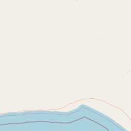
Map view of Nullarbor National Park

Use this park location map to pinpoint Nullarbor National Park in Australia, understand its exact geographic position, and read its mapped placement within the surrounding landscape more clearly.

Pigeon | © OpenStreetMap contributors

Location context for Nullarbor National Park

South Australia
Park atlas

Browse regional protected areas, comparing the arid terrain and distinctive limestone plains surrounding Nullarbor National Park.

Discover Other National Parks Near Nullarbor, Exploring South Australia's Unique Protected Landscapes
Explore additional national parks and protected areas geographically adjacent to Nullarbor National Park, tracing how these distinctive arid landscapes extend across South Australia. Compare varied conservation units within the broader Nullarbor Plain region, revealing the contiguous natural geography and diverse ecological features beyond one specific park.
National parkWestern Australia

Eucla National Park: Remote Coastal Protected Landscape in Western Australia

Explore limestone cliffs, sand dunes, and historic sites.

Eucla National Park showcases the dramatic interface of the Great Australian Bight with Western Australia's coastline. This protected area features striking limestone cliffs, vast migrating sand dune systems like the Delisser sandhills, and undulating mallee scrub. Discover the atmospheric ruins of the historic Eucla Telegraph Station, partially engulfed by dunes, and understand the unique geographic context and protected landscape identity of this remote national park.

Area
35.6 km²
IUCN
II
Access
Remote access
Water
Major water bodies
Marine protected areaSouth Australia

Great Australian Bight Marine National Park: Marine Protected Area Atlas and Geographic Context

Mapping the protected marine landscape of South Australia.

Delve into the geography and mapped boundaries of Great Australian Bight Marine National Park, a critical marine protected area located off the coast of South Australia. This resource provides an atlas-style view of the park, highlighting its geographic setting and significance as a protected marine environment. Understand the scope of this marine protected area and its place within the Australian geography, offering rich context for discovery and map exploration.

Area
1,233.22 km²
Established
1996
IUCN
II
Access
Access unknown
National parkSouth Australia

Lake Gairdner National Park: National Park with Unique South Australian Geography and Mapped Boundaries

South Australian protected area with distinct landscape characteristics.

Lake Gairdner National Park serves as a key protected area within the geographic expanse of South Australia. This national park offers a unique focus for atlas exploration, highlighting its specific landscape features and mapped boundaries. Users can delve into the park's protected status and its contribution to the regional geography, providing valuable context for understanding Australia's diverse natural protected lands and their cartographic representation.

Area
5,531.77 km²
Established
1991
IUCN
VI
Relief
Lowland
National parkSouth Australia

Coffin Bay National Park: Protected Landscape and Geographic Context in South Australia

Explore the mapped boundaries and regional geography of this national park.

Coffin Bay National Park presents a distinct protected landscape within South Australia, offering a valuable point of entry for geographic discovery. This page details the park's national park designation and its mapped territory, crucial for understanding its role in Australia's atlas of natural areas. Delve into the park's specific geographic context and the outlines of its protected lands, providing a clear picture of its landscape within the state's broader terrain.

Area
309.76 km²
Established
1982
IUCN
II
Relief
Lowland
National parkSouth Australia

Lincoln National Park National Park: Mapped Protected Area and Geographic Landscape Identity

South Australia's protected landscape with detailed park boundaries.

Gain a comprehensive atlas perspective on Lincoln National Park, a designated national park in South Australia. This resource details the park's mapped boundaries, offering clear geographic context and highlighting its role as a protected landscape. Understand its place within the regional geography of South Australia, providing essential data for landscape exploration and atlas-based research.

Area
216.38 km²
Established
1941
IUCN
II
Relief
Upland
Watercolor painting of green rolling hills and purple mountains under a pastel sky
National parkWestern Australia

Cape Arid National Park: A National Park Atlas Entry for Western Australia's Coast

Explore its mapped terrain and protected landscape identity.

Cape Arid National Park, located in Western Australia, is a substantial protected area notable for its striking coastal geography. This national park features a dramatic intersection of the Southern Ocean coastline with ancient granite landforms and low hills, creating a diverse mapped terrain. Its significance extends to being a key habitat for numerous bird species, making it a critical component of the regional protected-area network and a valuable point of study within the broader geographic atlas.

Area
2,794.46 km²
Established
1969
IUCN
II
Relief
Mixed relief
National parkSouth Australia

Lake Torrens National Park: Explore South Australia's Remarkable Inland Salt Lake Geography

A unique protected landscape of arid plains and expansive salt flats.

Lake Torrens National Park offers an unparalleled exploration of Australia's remote outback, centered around a vast, ancient salt lake basin. This national park in South Australia provides a canvas of stark, minimalist terrain, featuring shimmering saltpans, arid gibber plains, and rocky outcrops. Understand the park's unique geographic identity, its ecological significance as a temporary wetland habitat, and its dramatic visual appeal for landscape photography and geological interest. It is a key protected area showcasing the extreme environment of Australia's interior.

Area
5,676.68 km²
Established
1991
IUCN
VI
Relief
Lowland
National parkSouth Australia

Mount Remarkable National Park: Protected Landscape Atlas and South Australia Geography

Explore mapped boundaries and natural terrain.

Mount Remarkable National Park serves as a vital protected area within South Australia's unique geographic setting. This MoriAtlas entry details the park's mapped boundaries and surrounding natural terrain, providing structured insight into its landscape character and regional geographic importance. Understand the park as a key element of Australia's protected lands atlas.

Area
166.18 km²
Established
1972
IUCN
VI
Visitors
50K annual

Common questions about visiting, size, designation, and location context for Nullarbor National Park

Nullarbor National Park FAQs for park facts, access, geography, and protected area context
Find quick answers about Nullarbor National Park, including protected-area facts, park geography, trail and visitor context, and how the park fits into its surrounding country and regional landscape.
MoriAtlas Explorer

Continue Your Protected Areas Search Across the Global Atlas

Deepen your exploration by continuing the structured search for national parks and protected areas worldwide. Utilize the comprehensive filtering capabilities to compare different conservation landscapes and refine your understanding of global park geography. Discover more about the distribution and characteristics of protected natural areas.

Global natural geography