
Why Herseler Werth stands out
Herseler Werth is best known as a strictly protected nature reserve on a small poplar-planted Rhine island, notable as the last such island in North Rhine-Westphalia where public access is not allowed. Its combination of human-introduced forest cover, long-term exclusion of disturbance, and isolation by strong river currents has made it a refuge for plants and animals that are considered endangered within Germany.
Herseler Werth history and protected-area timeline
The island is understood to have been formed during a major westward flooding event of the Rhine between 1202 and 1237, which is thought to have carried away parts of the old village fabric of Hersel as well as sections of the historic Roman road between Bonn and Cologne. The carved-out channel and sediment patterns left behind by this event are believed to have produced the present-day footprint of Herseler Werth.
In the twentieth century, the island was planted with poplar trees after the Second World War, a measure that turned it into a uniform, grown-over patch of woodland within the river. Its ecological character changed again in 1993, when it was formally designated as a nature reserve within the German protected-area system, after which public access was forbidden.
In more recent decades the island and its surroundings have occasionally become locally prominent for non-natural reasons. In 2004 a young person drowned in the unusually strong current between the island and the Hersel bank, highlighting the danger of the waters around the protected site. In October 2009, during low-water works along the shore, a 500 kilogram aerial bomb from the Second World War was discovered and had to be detonated in a controlled explosion, requiring the evacuation of parts of Hersel and Uedorf on the left bank and parts of Rheidt and Mondorf on the right bank. At the southern end of the island, on the Hersel shore, the Herseler Wassersport-Verein 1930, a local canoeing club, still operates its boathouse, providing a small but persistent human presence adjacent to the protected area.
Herseler Werth landscape and geographic character
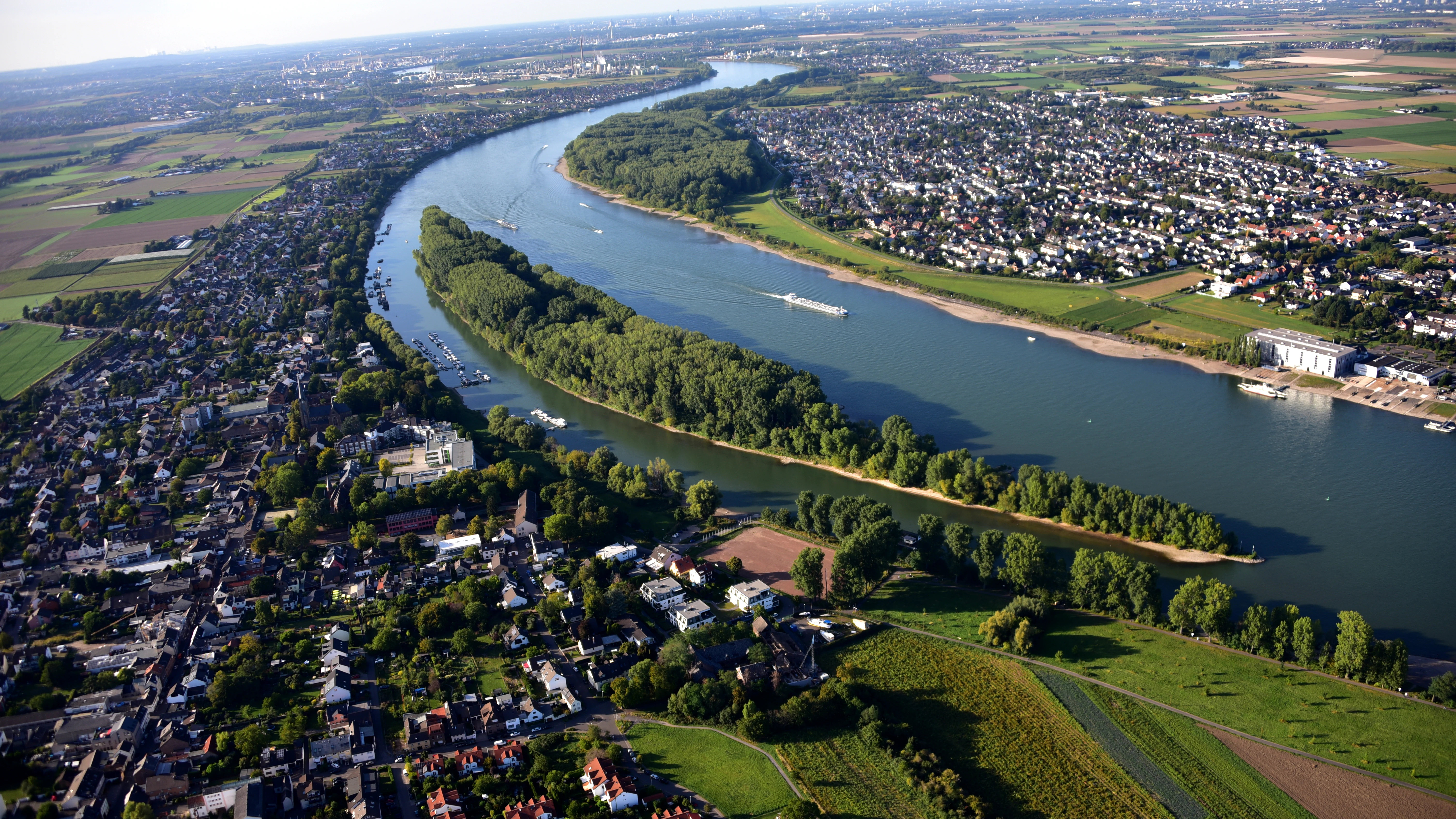
Herseler Werth is a long, narrow river island in the Middle Rhine corridor, roughly 1.68 kilometers in length and approximately 14.8 hectares in area, with no permanent residents. The island lies at Rhine kilometer 660.80, embedded in the flat alluvial landscape that characterizes this part of the Rhine valley between the low terraces of Bonn and the urban edge of Cologne.
The terrain is low-lying and shaped entirely by the river's hydrology. The defining landscape feature is the channel of fast-moving water between the island and the Hersel bank, where the Rhine develops an unusually strong current as it is constricted around the island's southern end. The island's own surface is uniformly wooded with planted poplars and lacks dramatic relief, but the combination of river, woodland, and protected status gives the location a visually simple but ecologically coherent character.
The surrounding landscape is a mix of agricultural lowlands, settlements of the Bornheim area, and the broader urban-rural transition that defines the southern edge of the Cologne-Bonn metropolitan corridor. From the shore, the island reads as a continuous band of trees along the river, while the wider setting is dominated by the open floodplain and the distant skylines of nearby towns.
Herseler Werth ecosystems, habitats, and plant life
Ecologically, Herseler Werth is defined by its status as a fully protected river island with no public access. The uniform canopy is composed of poplars planted by hand after the Second World War, but beneath this planted canopy the island's long-term exclusion from disturbance has allowed richer communities of plants and animals to develop. These include species that are classified as endangered in Germany and that appear on the national Red List of threatened species.
The combination of isolation by water, dense tree cover, and consistent protection creates conditions that are increasingly rare on Rhine islands, most of which are subject to recreational use, grazing, or development pressure. Herseler Werth therefore functions less as a primary natural ecosystem and more as a quiet refuge island, where habitat that has been allowed to mature undisturbed supports both common woodland species and rarer, disturbance-sensitive organisms.
Herseler Werth wildlife and species highlights
Because the island has been closed to the public since 1993 and is surrounded by strong river currents, it provides a refuge for plant and animal species that are considered endangered in Germany and that appear on the national Red List. The poplar woodland supports the usual range of temperate lowland woodland fauna associated with mature broadleaf stands in the Rhine valley.
The waters around the island are an important part of its wildlife context. The unusually strong current in the channel between Herseler Werth and the Hersel shore shapes the behavior of fish and other river organisms in this stretch of the Rhine and is one of the reasons why the shoreline environment around the island carries its own ecological value, in addition to the woodland habitat on the island itself. Detailed species inventories for the island are not extensively documented in available sources, so the accounts here remain focused on the ecological pattern rather than specific fauna lists.
Herseler Werth conservation status and protection priorities
Herseler Werth has been a designated nature reserve since 1993, placing it within the formal German system of protected areas and within the network of nature reserves of the Rhein-Sieg-Kreis. The reserve's central conservation measure is a strict access prohibition: the island may not be entered, which makes it the last such non-publicly accessible Rhine island in the state of North Rhine-Westphalia.
The conservation value of the site lies in the persistence of undisturbed woodland and shoreline habitat in a heavily used river system. By keeping out recreational, agricultural, and infrastructural pressure, the reserve allows endangered species to maintain a foothold in a landscape that would otherwise be too altered to support them. The park-style management model of a small, fully protected island in a major European river is itself notable and gives Herseler Werth a meaningful role in regional conservation discussions.
Herseler Werth cultural meaning and human context
The island has a place in the regional cultural memory that goes beyond its current protected status. Its origin is tied to a medieval flood event between 1202 and 1237 that destroyed parts of the old village of Hersel and a stretch of the ancient Roman road between Bonn and Cologne, an event that still resonates in how local history is told along this stretch of the Rhine.
In the modern era, the island is closely associated with the work of the Herseler Wassersport-Verein 1930, a canoeing club that maintains its boathouse on the Hersel bank at the southern end of the island. Although access to the island itself is forbidden, this club represents a continuing local human relationship with the river and the island, situated just outside the boundaries of the nature reserve. The 2009 discovery of an aerial bomb from the Second World War and the surrounding evacuation also tied the island into a more recent layer of regional memory.
Top sights and standout views in Herseler Werth
Herseler Werth stands out primarily because it is the last fully protected, non-accessible Rhine island in North Rhine-Westphalia, a status it has held since 1993. Its planted poplar woodland, its unusually strong surrounding currents, and its role as a refuge for Red List species together give the island an outsized ecological significance relative to its small footprint of 14.8 hectares. The combination of medieval flood history, post-war reforestation, and strict modern protection makes it a compact but distinctive example of how very small river islands can be managed for long-term biodiversity value.
Best time to visit Herseler Werth
Because Herseler Werth itself is closed to the public and can be observed only from the surrounding banks, river craft, or nearby crossings, the question of when to visit is more about conditions for viewing the island and walking the adjacent shoreline than about conditions on the island itself. Late spring and summer bring the poplars into full leaf and offer the richest foliage cover, while low-water periods in autumn can expose more of the island's edges and make the strong currents around it more visible.
Winter and early spring visits tend to give a clearer view through the bare branches of the poplars and often coincide with lower water levels along this part of the Rhine, which can make the island's outline easier to read from the Hersel bank. At any time of year, the unusually strong current in the channel between the island and the Hersel shore means that visitors should remain on the bank and not attempt to enter the water.