
Mori Atlas logo
Nature reserveKiesgruben Meschenich

Tracing the habitat mosaic and regional ecological network of this Cologne quarry landscape.

Kiesgruben Meschenich Nature Reserve: Geographic Mapping and Protected Landscape Analysis

(Naturschutzgebiet Kiesgruben Meschenich)

Kiesgruben Meschenich functions as a vital protected landscape on the southern edge of Cologne, Germany. This nature reserve, established in 1991, provides essential map-based insight into how former gravel extraction sites evolve into rich, layered environments. Visitors and researchers can analyze its specific terrain, which includes open quarry water, reed-fringed shorelines, dry grasslands, and scrubland, forming part of a significant biotope network that supports local amphibians, reptiles, and waterbirds.

gravel pitformer quarryquarry lakereedbedwetlandpioneer habitat
A flat-style digital illustration of a quarry pond with rocky cliffs, surrounding forest, and foreground vegetation.

Kiesgruben Meschenich

Nature reserve

Park overview

Structured park overview, official facts, and landscape profile for Kiesgruben Meschenich

Kiesgruben Meschenich park facts, protected area profile, and essential visitor context

Review the core facts for Kiesgruben Meschenich, including designation, size, terrain, visitor scale, habitats, and operating context in one park-focused overview.

About Kiesgruben Meschenich

Kiesgruben Meschenich is a small but ecologically significant protected area in the southern outskirts of Cologne. Covering roughly 26.51 hectares, the reserve occupies the site of a former gravel quarry whose abandoned workings have been gradually recolonized by nature. The result is a layered landscape dominated by a sizeable open-water lake bordered by sparse reed vegetation, with a larger reedbed extending to the northwest and a separate smaller pit holding reed, bulrush, and patches of dry grassland to the west. The whole complex is interspersed and surrounded by planted trees, shrubs, and spontaneous wild growth, creating a transition between cultivated woodland and open habitat.

The defining character of the reserve lies in the way raw, disturbed ground, open water, reed margins, dry grassland, and scrub interact on a very compact scale. Roughly nine hectares are taken up by the quarry lake itself, with surrounding scrub and tree groups covering about thirteen hectares, reeds and related marshy habitats extending over more than a hectare, and small but ecologically important patches of vegetation-poor sand, gravel, and scree. The natural eutrophic lake hosts water plants listed on regional red lists, while the western pit combines reed communities with bulrush stands and dry grassland fragments. Planted tree groups and natural regrowth frame and infiltrate the area, blurring the boundary between open habitat and woodland edge.

The site's significance is reinforced by its place within a wider biotope network of gravel-pit locations in the Cologne region, of which Kiesgruben Meschenich is one node. This network is important for maintaining populations of waterbirds, amphibians, lizards, and butterflies, many of which depend on the specific combination of open water, exposed substrate, and reed margins that the site's gravel-pit history has produced. Although the reserve is modest in size, the density and diversity of habitat types it contains make it a disproportionately rich element of Cologne's protected-area system.

Quick facts and research context for Kiesgruben Meschenich

Kiesgruben Meschenich is a 26.51-hectare nature reserve located south of the Cologne district of Meschenich in North Rhine-Westphalia, Germany. The site is a former gravel extraction area that has been protected as a Naturschutzgebiet since 1991. Its habitat mosaic includes an open-water quarry lake with islands, reedbeds, low pioneer vegetation on raw gravel substrates, dry grassland, and mixed woodland planting. The reserve forms part of a biotope network of gravel pit sites across the Cologne region, giving it regional importance for waterbirds, amphibians, lizards, and butterflies.

Protection and recognition

Review documented terrestrial protection scope and recognized conservation data.

Kiesgruben Meschenich Protection Status and Official Designation Facts

Kiesgruben Meschenich brings together documented terrestrial protection metrics and official conservation status records for structured analysis. Review verified designation data and management parameters associated with this protected natural area.

Protection details

Protection scope
Terrestrial
Park context

Deeper park guide and search-rich context for Kiesgruben Meschenich

Kiesgruben Meschenich history, landscape, wildlife, and travel context

Explore Kiesgruben Meschenich through its history, landscape character, ecosystems, wildlife, conservation priorities, cultural context, and seasonal travel timing in a structured park guide built for atlas discovery and search intent.

Why Kiesgruben Meschenich stands out

Kiesgruben Meschenich is best known for its combination of a small, reed-fringed quarry lake with two islands and a varied mosaic of pioneer, reedbed, dry grassland, and scrub habitats originating from former gravel extraction. It stands out as one of several linked gravel-pit nature reserves in the Cologne area, offering habitat for waterbirds, amphibians, reptiles, and invertebrates in a setting where such natural open-water and reed communities are otherwise rare.
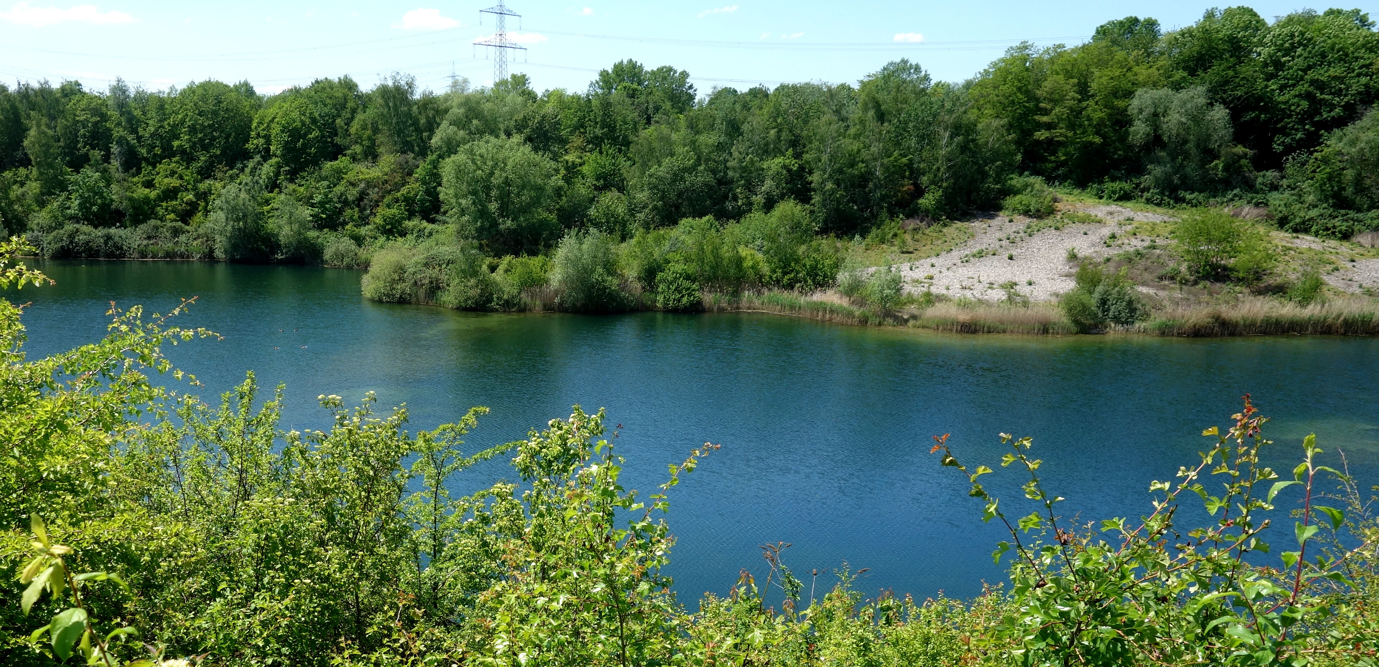
A wide view of a deep blue quarry pond surrounded by green trees, bushes, and an exposed gravel bank under a clear sky.
A view of the water and surrounding vegetation at the Kiesgruben Meschenich nature reserve.

Kiesgruben Meschenich history and protected-area timeline

Kiesgruben Meschenich takes its character from a former gravel extraction site on the southern fringe of Cologne's Meschenich district. The site's protected status reflects a conservation decision taken in 1991, when the area was formally designated as a Naturschutzgebiet, or nature reserve, under German nature protection law. That designation recognized both the ecological value that had developed on the abandoned quarry surface and the area's role within a wider network of gravel-pit habitats in the Cologne region.

The reserve's history is therefore closely tied to the regional history of sand and gravel extraction along the Rhine, where working pits were frequently left to regenerate naturally once extraction was finished. Rather than being restored or filled in, the Meschenich site was allowed to develop as a near-natural mosaic of water, reed, scrub, and woodland, which has shaped the modern character of the protected area.

Kiesgruben Meschenich landscape and geographic character

The landscape of Kiesgruben Meschenich is shaped entirely by its gravel-pit origins. The dominant feature is a quarry lake occupying the eastern portion of the reserve, with two small islands and water plants that are regionally significant. The shoreline is thinly fringed with reed, while a larger reedbed opens out to the northwest of the lake, softening the transition between open water and land. To the west, a smaller pit holds reed, bulrush stands, and patches of dry grassland, providing a different micro-landscape within the same protected area.

Around these water and marsh features, the ground is a mix of tipped raw gravel substrates, scattered pioneer vegetation, planted mixed woodland, and patches of natural scrub and wild growth. The interplay between exposed mineral substrate, fringing marsh, dry grassland, and encroaching woodland creates a varied micro-topography and gives the reserve its layered, transitional feel, despite the relatively small overall footprint.

Kiesgruben Meschenich ecosystems, habitats, and plant life

Ecologically, Kiesgruben Meschenich is notable for the unusually wide range of habitats compressed into a small area. The lake and surrounding marsh fall largely within the habitat type of natural eutrophic lakes with vegetation of the Magnopotamion or Hydrocharition, supporting aquatic plants that are regionally rare or threatened. Reedbeds and related marsh vegetation, including reed and bulrush stands, occupy a smaller but ecologically important share of the site. Patches of vegetation-poor sand, gravel, and raw ground provide pioneer habitats, while the broader matrix of scrub, tree groups, and mixed woodland adds woodland-edge and shrub communities to the overall habitat palette.

The reserve's combination of open water, fringing marsh, pioneer ground, dry grassland, and scrub supports a rich plant flora typical of post-extraction regeneration in the Rhine plain. Aquatic species such as white water lily, spiked water milfoil, various pondweeds, rough hornwort, and Canadian and Nuttall's waterweed populate the lake, while reed, bulrush, and a range of sedges establish the marsh margins. The drier parts of the site host common broom, bramble, dewberry, dog rose, and a variety of grasses and wildflower species, together with planted and naturally spreading trees such as ash, field maple, sycamore, birch, oak, alder, willow, wild cherry, and black locust.

Kiesgruben Meschenich wildlife and species highlights

Although the reserve is small, its mosaic of habitats gives it regional ecological significance for several animal groups. The quarry lake, reedbeds, and dry grassland fragments provide important conditions for waterbirds, including species such as the sedge warbler and grey partridge, which have been highlighted in local conservation reporting. Amphibians use the open water and marsh habitats, while reptiles, including lizards, benefit from the combination of sunny raw ground, scrub, and structural variation. Butterflies are supported by the mosaic of dry grassland, pioneer vegetation, and flowering scrub, contributing to the site's invertebrate interest.

The reserve's value for these groups is amplified by its position within a larger network of gravel-pit sites around Cologne, which together act as step stones for species that depend on open water, reed, and disturbed ground in a heavily urbanized landscape.

Kiesgruben Meschenich conservation status and protection priorities

Kiesgruben Meschenich has been protected as a Naturschutzgebiet since 1991, reflecting both the site's intrinsic biodiversity and its role as a node in the broader biotope network of gravel-pit reserves in the Cologne region. Conservation efforts focus particularly on maintaining the open-water surface, the reedbeds, and the pioneer raw-ground habitats, all of which are scarce in the surrounding urban and agricultural matrix and are difficult to replace once lost.

The reserve also has cultural and regional significance as an example of how former industrial extraction sites can be transformed into ecologically valuable protected areas. Local reporting has drawn attention to concerns about specific species such as the sedge warbler and grey partridge, underlining the need for ongoing management to keep the habitat mosaic open, varied, and capable of supporting its characteristic wildlife.

Kiesgruben Meschenich cultural meaning and human context

Kiesgruben Meschenich sits at the rural edge of the Cologne district of Meschenich, on the boundary between the city and the surrounding agricultural and gravel-extraction landscape of the Lower Rhine plain. The reserve reflects a broader cultural pattern in the region, where former sand and gravel workings along the Rhine have been turned into protected natural spaces as the quarries were worked out or closed. Within this context, the protected area is less a landscape of traditional human settlement than a product of modern industrial land use reclaimed by ecological thinking, and it represents one of many small green oases embedded in a heavily populated urban region.

Top sights and standout views in Kiesgruben Meschenich

A compact nature reserve on the southern edge of Cologne, built on a former gravel quarry and protected since 1991.

A rare local combination of an open quarry lake with islands, fringing reedbeds, dry grassland, pioneer raw-ground habitats, and mixed woodland.

Part of a regional biotope network of gravel-pit sites that together sustain waterbirds, amphibians, reptiles, and butterflies in the Cologne area.

Best time to visit Kiesgruben Meschenich

Because Kiesgruben Meschenich is a protected nature reserve focused on habitat conservation rather than visitor infrastructure, its character varies mainly with the seasons in terms of wildlife viewing and plant life rather than in terms of access. Spring and early summer are typically the most rewarding periods for visiting similar reedbed and gravel-pit reserves in the region, when reed warblers and other waterbirds are active, amphibians are breeding in the open water, and butterflies are present along the dry grassland and scrub margins. Late summer offers a different perspective with mature reed stands and seed-setting vegetation, while autumn and winter can be quieter but still valuable for observing waterbird use of the lake. Visitors should approach the site as a low-disturbance natural area rather than a developed visitor destination.


Monthly climate preview

Long-term representative coordinate measurements mapping twelve-month environmental rhythms

Kiesgruben Meschenich Climate Normals, Annual Temperature and Precipitation Patterns

Kiesgruben Meschenich exhibits a recorded annual temperature progression from sub-zero winter minimums to warm summer maximums alongside consistent daily precipitation distribution. Examining the complete monthly climate dataset provides structured context for long-term environmental patterns across the protected coordinate.
Annual mean10 °C
1 °C19 °C
Jan
Feb
Mar
Apr
May13°
Jun17°
Jul19°
Aug19°
Sep15°
Oct10°
Nov
Dec
Warmest month
July

19.2 °C

Coolest month
January

1.3 °C

Wettest month
December

2.6 mm/day

Driest month
April

1.6 mm/day

Park location guide

Geography guide, regional context, and park location map for Kiesgruben Meschenich

Kiesgruben Meschenich park geography, regions, and map view in Germany

Understand where Kiesgruben Meschenich sits in Germany through a broader geographic reading of the surrounding landscape, nearby location context, and its mapped position within the national park landscape.

How Kiesgruben Meschenich fits into Germany

Germany is a federal republic in Western and Central Europe with a population of over 83 million across sixteen constituent states. It is Europe's largest economy by nominal GDP and a major global exporter and importer. The capital is Berlin, and the country borders Denmark, Poland, Czech Republic, Austria, Switzerland, France, Luxembourg, Belgium, and the Netherlands.

Wider geography shaping Kiesgruben Meschenich in Germany

Germany is located in Western and Central Europe, spanning 357,022 km². It borders Denmark to the north, Poland and the Czech Republic to the east, Austria and Switzerland to the south, and France, Luxembourg, Belgium, and the Netherlands to the west. The country has coastlines on the Baltic Sea and North Sea to the north, with the Alps located in the southern region.

Map view of Kiesgruben Meschenich

Use this park location map to pinpoint Kiesgruben Meschenich in Germany, understand its exact geographic position, and read its mapped placement within the surrounding landscape more clearly.

Pigeon | © OpenStreetMap contributors

Explore detailed visual records of the quarry lake, reedbeds, and pioneer habitats.

Kiesgruben Meschenich Landscape and Scenery: Visualizing the Protected Quarry Environment

Visual documentation reveals the distinctive terrain and habitat mosaic of Kiesgruben Meschenich through detailed imagery of its quarry lake and reed-fringed shorelines. Examining these protected area views helps researchers understand the ecological recovery and micro-topography of this unique gravel-pit nature reserve.

A wide view of a deep blue quarry pond surrounded by green trees, bushes, and an exposed gravel bank under a clear sky.

Park atlas

Compare regional wetland habitats and connected conservation landscapes

Explore Other Parks and Protected Areas Near Kiesgruben Meschenich

Browse nearby protected areas and related gravel pit reserves to understand the wider ecological network surrounding Kiesgruben Meschenich. Comparing adjacent habitats reveals how fragmented wetland biotopes and reedbed reserves function across the regional landscape.
A horizontal watercolor painting depicting a gentle, hazy green landscape with rolling hills, a line of trees, and a foreground meadow.
Protected landscapeNorth Rhine-Westphalia
Mapped location lies within the park boundary#1 closest

Southwest

Naturpark Rheinland: Geography and Protected Area Overview in North Rhine-Westphalia

A complex metropolitan nature park and lake district

Naturpark Rheinland represents a distinct convergence of reclaimed lignite mining landscapes, quiet lowland forests, and floodplain wetlands. Its mapped boundaries reveal a diverse terrain of ridges and river valleys that define the environmental character of the Cologne-Bonn metropolitan region.

Area
1,045 km²
Established
1959
Relief
Upland
Climate
Temperate
Watercolor landscape illustration showing a pale river curving through green trees with soft hills in the distance.
Nature reserveNorth Rhine-Westphalia
About 3.8 km away#2 closest

East

Langeler Auwald: A Protected Floodplain Forest in the North Rhine-Westphalia Rhine Corridor

Examining fluvial landscape patterns and riparian forest boundaries

Langeler Auwald functions as a significant nature reserve on the right bank of the Rhine in Cologne, preserving a rare mosaic of willow-poplar floodplain forest. The terrain encompasses periodically flooded gravel shores, nutrient-poor grasslands on flood dikes, and transitional orchard habitats that support a high density of protected species within the urbanized landscape of North Rhine-Westphalia.

Area
0.224 km²
Relief
Lowland
Climate
Temperate
Scope
Terrestrial
A horizontal watercolor painting depicting a calm lake surrounded by low, rolling hills and coniferous trees under a soft, pale sky.
Nature reserveNordrhein-Westfalen
About 5.4 km away#3 closest

Southwest

Heider Bergsee Nature Reserve: Geographic Context and Protected Landscape Map

A recovered lake landscape in the North Rhine-Westphalia region of Germany

Discover the complex geography of Heider Bergsee, a prominent nature reserve and post-mining lake in the Ville region. This area showcases how nutrient-poor water and managed forest edges create a vital ecosystem within North Rhine-Westphalia, providing a distinct study in landscape restoration and protected-area mapping.

Area
0.354 km²
Established
1965
Relief
Lowland
Climate
Temperate
A watercolor illustration showing a landscape with a calm lake surrounded by greenery, small trees, and gently rolling hills in the background.
Nature reserveNordrhein-Westfalen
About 6.9 km away#4 closest

West

Hürther Waldsee Nature Reserve: Mapped Protected Geography and Reclaimed Mining Landscape

Ecological refuge on the Ville lake plateau of Germany

Examine the boundaries and natural features of Hürther Waldsee, a significant nature reserve in the Nordrhein-Westfalen region. This ten-hectare reclaimed mining lake offers a detailed map of post-industrial ecological recovery, featuring engineered islands, reed beds, and young beech and alder woodlands that define its protected status.

Area
0.106 km²
Established
1988
Relief
Lowland
Access
Moderate access
A soft, pale watercolor illustration of a lake with small islands and a low, distant treeline.
Nature reserveNorth Rhine-Westphalia
About 9.8 km away#5 closest

Northeast

Kiesgrubensee Gremberghoven Nature Reserve Geographic and Protected Area Overview

A restored industrial gravel pit ecosystem in North Rhine-Westphalia.

Kiesgrubensee Gremberghoven functions as a protected nature reserve in the Cologne metropolitan area. The site is defined by its origin as a former gravel excavation, now containing a substantial lake that attracts waterbirds and supports cliff-nesting colonies along its steep sandy slopes. This location serves as an informative case study for understanding how industrial remnants in German landscapes can be rehabilitated for conservation and ecological study.

Area
0.377 km²
Established
1989
Relief
Lowland
Climate
Temperate
Nature reserveCologne
About 10 km away#6 closest

East

Kiesgruben Paulsmaar Nature Reserve: Landscape and Geography in the Cologne Urban Fringe

A managed mosaic of post-industrial gravel pits and wetland habitats.

Kiesgruben Paulsmaar represents a distinct example of urban-edge habitat restoration in western Germany. Located near the border of Cologne, this 24-hectare nature reserve consists of three interconnected water bodies, floodplain forests, and calcareous grasslands. It serves as a regional refuge for biodiversity while documenting the conversion of former industrial land into a functioning wetland ecosystem.

Area
0.247 km²
Established
1991
Relief
Lowland
Climate
Temperate
Nature reserveNorth Rhine-Westphalia
About 11 km away#7 closest

East

Kiesgrube Wahn Nature Reserve: Mapped Geography and Protected Area Context

Protected landscape within the Bergische Heideterrasse of North Rhine-Westphalia

Kiesgrube Wahn provides a compact, high-value ecological mosaic in Cologne, Germany. This former gravel pit has transitioned into a protected nature reserve, hosting a range of aquatic and woodland environments that support rare plant and animal communities within the regional gravel-pit network.

Area
0.054 km²
Established
1988
Relief
Lowland
Access
Highly restricted
A soft watercolor painting showing a winding river with a lush green island in the middle, surrounded by soft-toned riverbanks and trees.
Nature reserveNorth Rhine-Westphalia
About 11 km away#8 closest

Southeast

Herseler Werth Nature Reserve: Geographic Overview of the Rhine River Island Landscape

A strictly protected riverine refuge in North Rhine-Westphalia

Herseler Werth represents a unique study in protected geography as the only non-publicly accessible Rhine island within North Rhine-Westphalia. Spanning 14.8 hectares, this long, narrow river island serves as a critical, human-excluded sanctuary that protects endangered species from industrial and urban disturbance. Its mapped boundaries and poplar-covered terrain illustrate the complex interaction between historical river hydrology and modern conservation efforts along the busy Bonn-Cologne corridor.

Area
0.148 km²
Established
1993
Relief
Lowland
Climate
Temperate

Common questions about visiting, size, designation, and location context for Kiesgruben Meschenich

Kiesgruben Meschenich FAQs for park facts, access, geography, and protected area context

Find quick answers about Kiesgruben Meschenich, including protected-area facts, park geography, trail and visitor context, and how the park fits into its surrounding country and regional landscape.
MoriAtlas Explorer

Continue Your Protected Areas Search Across the Global Atlas

Deepen your exploration by continuing the structured search for national parks and protected areas worldwide. Utilize the comprehensive filtering capabilities to compare different conservation landscapes and refine your understanding of global park geography. Discover more about the distribution and characteristics of protected natural areas.

Global natural geography