
Mori Atlas logo
Nature reserveLangeler Auwald

Mapping the ecological boundaries and fluvial dynamics of this protected riparian zone

Langeler Auwald Nature Reserve: A Detailed Atlas of Rhine Floodplain Landscapes and Terrain

(Naturschutzgebiet Langeler Auwald, rechtsrheinisch (K-018))

Langeler Auwald represents a vital fragment of softwood floodplain forest located along the banks of the Rhine in North Rhine-Westphalia. This nature reserve protects a mosaic of shifting gravel shores, willow-poplar woodlands, and managed grasslands that illustrate the natural fluvial processes of the middle Rhine valley. The area serves as an essential refuge for diverse breeding bird species, bats, and amphibians, offering a clear window into the intersection of protected riverine ecosystems and industrial-urban corridors.

floodplain forestsoftwood floodplainRhine river corridorgravel shoreriparian woodlanddry grassland
Stylized illustration of a mountain valley with a river, waterfall, and mixed forest under a sunny sky.

Langeler Auwald

Nature reserve

Park overview

Structured park overview, official facts, and landscape profile for Langeler Auwald

Langeler Auwald park facts, protected area profile, and essential visitor context

Review the core facts for Langeler Auwald, including designation, size, terrain, visitor scale, habitats, and operating context in one park-focused overview.

About Langeler Auwald

Langeler Auwald occupies a thin but ecologically meaningful slice of the Rhine floodplain on the right bank of the river, directly opposite the Godorf harbor. The reserve represents one of the few places in this heavily modified stretch of the Rhine where the natural pattern of shifting gravel shores, softwood floodplain forest, and levee grasslands can still be experienced, even if on a compressed spatial scale.

The landscape is defined by a 50 to 100 meter wide zone that runs parallel to the river, where periodic flooding continues to shape the vegetation. Closest to the water lies a strip of gravel shore with strandline plant communities that respond dynamically to changing water levels. Inland from that, a willow and poplar softwood floodplain remnant survives, interspersed with older ash trees whose trunks reach 50 to 90 centimeters in diameter. Drainage channels running parallel to the river cut through the grazed poplar stands and support mixed ash-poplar woodland with tall nitrophilous herb vegetation.

Behind the forest belt, the reserve extends inland to include agricultural and semi-natural elements typical of the cultural Rhine floodplain: intensively used meadows, a light poplar stand grazed by horses, ponies, and cattle, an orchard fallow, a young orchard with newly planted fruit trees and short mown lawn, and a small arable field bordered by hedgerows. Along the crest of the flood dike, dry grassland vegetation adds an open, species-rich habitat that contrasts with the wetter floodplain below.

Although only about 22 hectares in size, Langeler Auwald functions as a compact ecological island that links aquatic, riparian, woodland, grassland, and orchard habitats within a single, easily legible landscape. Its position within the city of Cologne makes it a notable example of how biodiversity can be maintained even in close proximity to industrial harbor facilities, rail corridors, and urban settlement, demonstrating the continuing ecological value of the Rhine's floodplain mosaics.

Quick facts and research context for Langeler Auwald

Langeler Auwald is a designated nature reserve in the city of Cologne, Germany, located in the Langel district within the Porz borough on the right bank of the Rhine. The reserve, catalogued as K-018, covers about 22 hectares along a sweeping bend of the Rhine near Wesseling. Its habitats include periodically flooded gravel banks, willow-poplar softwood floodplain forest remnants, grazed poplar stands, meadows, orchard fallows, and a levee with dry grassland vegetation.

Protection and recognition

Terrestrial protected area records and international recognition data

Langeler Auwald Protection Status and Documented Conservation Framework

Langeler Auwald maintains a recorded terrestrial protection status within global conservation databases. Verified administrative details and international recognition records outline the formal designation framework for this protected area.

Protection details

Protection scope
Terrestrial
WDPA ID
164345
Park context

Deeper park guide and search-rich context for Langeler Auwald

Langeler Auwald history, landscape, wildlife, and travel context

Explore Langeler Auwald through its history, landscape character, ecosystems, wildlife, conservation priorities, cultural context, and seasonal travel timing in a structured park guide built for atlas discovery and search intent.

Why Langeler Auwald stands out

Langeler Auwald is best known as a surviving remnant of the Rhine's softwood floodplain forest (Weichholzaue), a habitat that has largely disappeared along the heavily engineered middle Rhine. The reserve preserves a narrow strip of willow and poplar forest that is still shaped by natural flooding dynamics, together with strandline vegetation along shifting gravel banks and patches of nutrient-poor grassland on the adjoining flood dike. It is also valued for the unusually high density of Red List breeding birds documented in such a small area, along with its amphibian, bat, and insect diversity, making it a small but ecologically rich refugium within the urban-industrial landscape of the southern Cologne Rhine corridor.
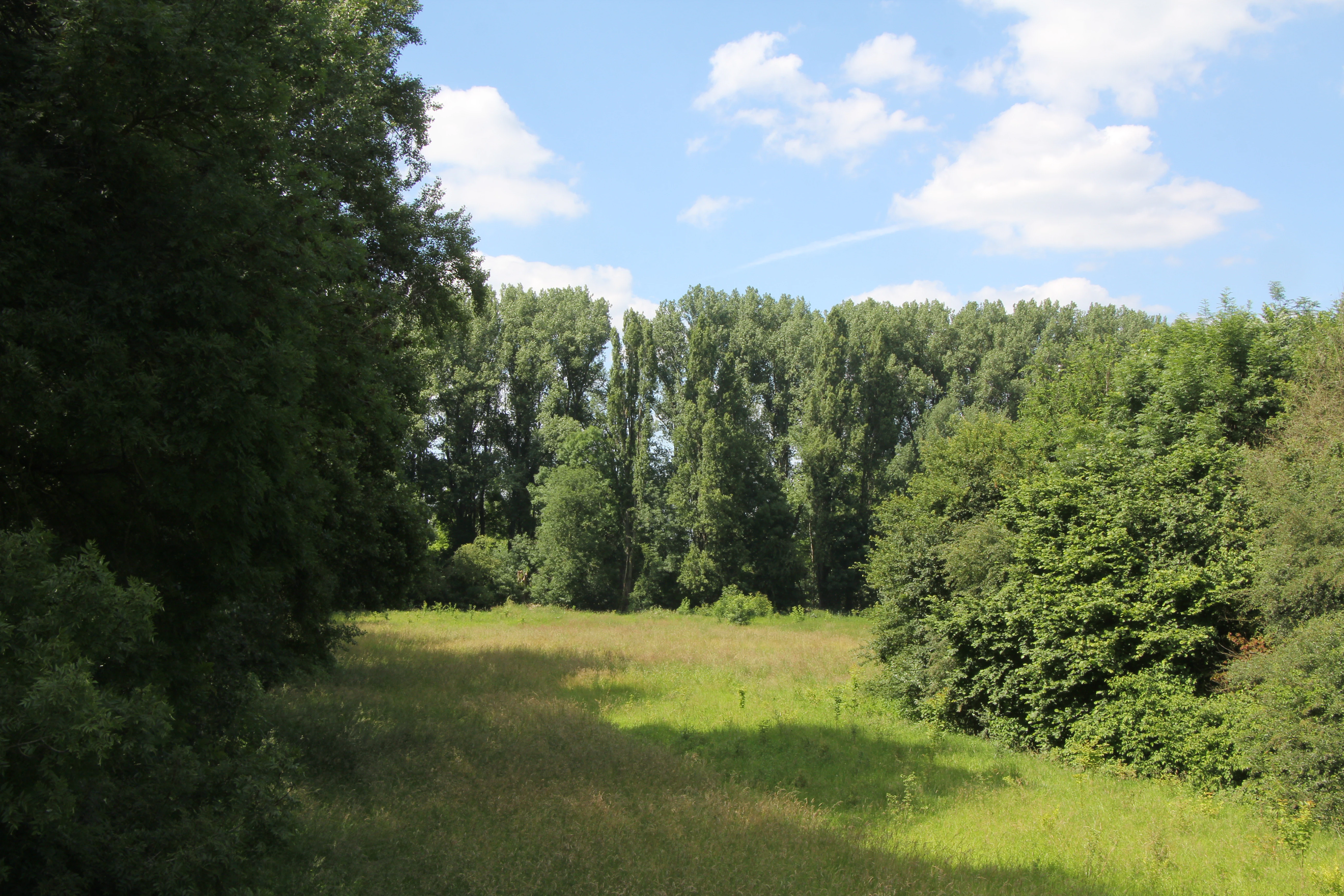
A green meadow surrounded by dense forest and tall trees under a blue sky with clouds.
A grassy clearing bordered by tall trees in the Langeler Auwald nature reserve.

Langeler Auwald landscape and geographic character

The Langeler Auwald landscape is a narrow, river-controlled strip along the right bank of the Rhine at the Wesseling river bend. Its most immediate landform is the shifting gravel shore, a 50 to 100 meter wide band of coarse sediment that is periodically inundated and reworked by the river, supporting strandline vegetation typical of dynamic freshwater shores.

Inland from the gravel shore, the terrain rises gently into a levee system. The forest belt between shore and dike is dominated by willows and poplars, the classic pioneer trees of the Rhine's softwood floodplain. Through the grazed poplar stands, shallow parallel drainage channels create micro-topographic variation, supporting mixed ash and poplar woodland with taller herb communities in the wetter furrows.

The flood dike itself forms a distinct landscape element, capped by dry, nutrient-poor grassland that contrasts sharply with the wetter habitats at its base. Between the dike and the Rhine floodplain mosaic lie flatter areas of grassland, orchard fallows, a managed young orchard, and a small arable plot bordered by field hedgerows, all of which together create the patchwork appearance that defines the Rhine's traditional cultural floodplain environment in this part of Cologne.

Langeler Auwald ecosystems, habitats, and plant life

The reserve protects a densely layered sequence of habitats compressed into a small area, ranging from open gravel shore and strandline vegetation through willow-poplar softwood floodplain forest to ash-poplar mixed stands and dry grassland on the levee. This habitat mosaic allows many different plant communities to coexist within a very short distance of one another.

Along the gravel shore, pioneer and strandline plant communities dominate, adapted to regular flooding and sediment movement. Within the softwood floodplain remnant, willows and poplars form the characteristic canopy, while older ash trees with trunks up to 50 to 90 centimeters across add structural complexity and continuity. The channels through the grazed poplar stands support tall nitrophilous herbaceous vegetation, and the dike-top dry grasslands harbor a distinctly different, more nutrient-poor flora.

Among cultivated and semi-cultivated elements, the reserve includes an orchard fallow, a replanted orchard with regularly mown lawn, and small field areas with hedgerows, all of which contribute additional habitat niches. The combination of natural floodplain vegetation, traditional orchard structures, and dike grassland gives the area a layered ecological character unusual within an urban context.

Langeler Auwald wildlife and species highlights

Wildlife is one of the most distinctive features of Langeler Auwald. Despite its small size, the reserve supports nineteen breeding bird species that appear on Germany's Red List of breeding birds, an unusually high concentration for such a compact area. Species recorded as residents or breeders include the common cuckoo, the gray partridge, and the little ringed plover, with the latter benefitting directly from the open gravel shore habitat.

Seven bat species are documented within the reserve, likely using the mix of mature trees, open foraging areas, and channel corridors as both roosting and feeding habitat. The amphibian fauna is also described as rich, taking advantage of the wet channels, seasonally flooded areas, and varied microtopography.

Insect diversity is significant as well, with notable populations of butterflies and grasshoppers, particularly in the drier grassland and orchard habitats. Together, the bird, bat, amphibian, and insect communities make Langeler Auwald a small but disproportionately rich wildlife refugium within the lower Rhine landscape.

Langeler Auwald conservation status and protection priorities

Langeler Auwald is designated as a Naturschutzgebiet, the strictest category of nature protection available under German nature conservation law, which provides a high level of legal protection for its habitats and species. Its principal conservation value lies in preserving one of the last remnants of softwood floodplain forest on this section of the Rhine, a habitat type that has been extensively reduced by river engineering, flood control, and agricultural conversion.

The reserve also has a strong conservation significance for breeding birds, since nineteen of its breeding species are on Germany's Red List. This makes the area important not only for habitat preservation but also for maintaining populations of vulnerable bird species in an otherwise urbanized and industrialized stretch of the Rhine valley.

By combining protected natural floodplain forest, grazed poplar stands, dry levee grassland, and traditional orchard habitats, the reserve also functions as a refugium for bats, amphibians, and invertebrate communities. Its location within the city of Cologne underscores the importance of small, protected floodplain fragments in maintaining ecological connectivity and species survival in heavily used river landscapes.

Langeler Auwald cultural meaning and human context

The reserve is embedded in a landscape that has long been shaped by human use of the Rhine floodplain. Orchards, meadows, grazed woodlands, and the flood dike itself reflect centuries of interaction between local communities and the river, blending traditional rural land use with natural floodplain dynamics.

The continued grazing of parts of the poplar stand by horses, ponies, and cattle, and the maintenance of both an old orchard fallow and a newly planted orchard, indicate an ongoing relationship between the area's cultural land use and its modern conservation management, preserving elements of the traditional Rhine landscape within a protected natural setting.

Top sights and standout views in Langeler Auwald

A 22 hectare Rhine floodplain reserve on the right bank of the Rhine in Cologne-Langel, protecting a rare surviving fragment of willow-poplar softwood floodplain forest together with shifting gravel shores, grazed poplar stands, and dry grassland on the flood dike. The reserve hosts nineteen Red List breeding bird species, seven bat species, rich amphibian populations, and a notable diversity of butterflies and grasshoppers, all within walking distance of one of Germany's largest cities.

Best time to visit Langeler Auwald

Because the reserve is shaped by the seasonal hydrology of the Rhine, periods of lower water expose the widest extent of the gravel shore and strandline vegetation, making them good times to observe pioneer plant communities and shore-nesting birds such as the little ringed plover. Spring and early summer bring the highest bird activity, when breeding territories of cuckoo, partridge, and other species are most easily detected, and the dike grasslands are at their most floristically visible.

Late spring through summer is also the main season for butterflies, grasshoppers, and flowering plants in the drier orchard and levee habitats. Visitors interested in amphibian activity may find the wet channels and seasonally flooded sections most rewarding in early spring, while flooding events at any season visibly reshape the gravel shore and underline the dynamic character of the reserve.


Monthly climate preview

Long-term representative measurements of monthly temperature and precipitation rhythm

Langeler Auwald Climate Normals and Annual Temperature Patterns

Langeler Auwald exhibits a measured annual temperature and precipitation rhythm spanning long-term averages from NASA POWER climatology data. Examining the complete twelve-month profile reveals detailed monthly variations across representative coordinates.
Annual mean10 °C
1 °C19 °C
Jan
Feb
Mar
Apr
May13°
Jun17°
Jul19°
Aug19°
Sep15°
Oct10°
Nov
Dec
Warmest month
July

19.2 °C

Coolest month
January

1.3 °C

Wettest month
December

2.6 mm/day

Driest month
April

1.6 mm/day

Park location guide

Geography guide, regional context, and park location map for Langeler Auwald

Langeler Auwald park geography, regions, and map view in Germany

Understand where Langeler Auwald sits in Germany through a broader geographic reading of the surrounding landscape, nearby location context, and its mapped position within the national park landscape.

How Langeler Auwald fits into Germany

Germany is a federal republic in Western and Central Europe with a population of over 83 million across sixteen constituent states. It is Europe's largest economy by nominal GDP and a major global exporter and importer. The capital is Berlin, and the country borders Denmark, Poland, Czech Republic, Austria, Switzerland, France, Luxembourg, Belgium, and the Netherlands.

Wider geography shaping Langeler Auwald in Germany

Germany is located in Western and Central Europe, spanning 357,022 km². It borders Denmark to the north, Poland and the Czech Republic to the east, Austria and Switzerland to the south, and France, Luxembourg, Belgium, and the Netherlands to the west. The country has coastlines on the Baltic Sea and North Sea to the north, with the Alps located in the southern region.

Map view of Langeler Auwald

Use this park location map to pinpoint Langeler Auwald in Germany, understand its exact geographic position, and read its mapped placement within the surrounding landscape more clearly.

Pigeon | © OpenStreetMap contributors

Location context for Langeler Auwald

North Rhine-Westphalia

Visual reference collection showcasing the floodplain forest, gravel shores, and riparian habitats of Langeler Auwald.

Langeler Auwald Photos, Landscape Scenery, and Protected Area Views

Examine detailed photography of Langeler Auwald to understand its unique softwood floodplain forest, shifting gravel banks, and riverine terrain. Visual records illustrate the diverse habitats and protected scenery that characterize this urban nature reserve along the Rhine.

A green meadow surrounded by dense forest and tall trees under a blue sky with clouds.

Park atlas

Compare adjacent floodplain reserves and connected river corridor landscapes

Exploring Parks Near Langeler Auwald and Surrounding Regional Protected Areas

Browsing parks near Langeler Auwald reveals a diverse network of protected river habitats and riparian woodlands throughout the surrounding region. Extending the geographic comparison allows visitors to examine similar floodplain remnants and connected conservation landscapes along the Rhine corridor.
A horizontal watercolor painting depicting a gentle, hazy green landscape with rolling hills, a line of trees, and a foreground meadow.
Protected landscapeNorth Rhine-Westphalia
About 2.6 km away#1 closest

West

Naturpark Rheinland: Geography and Protected Area Overview in North Rhine-Westphalia

A complex metropolitan nature park and lake district

Naturpark Rheinland represents a distinct convergence of reclaimed lignite mining landscapes, quiet lowland forests, and floodplain wetlands. Its mapped boundaries reveal a diverse terrain of ridges and river valleys that define the environmental character of the Cologne-Bonn metropolitan region.

Area
1,045 km²
Established
1959
Relief
Upland
Climate
Temperate
A soft watercolor illustration of a serene pond surrounded by gentle green hills and lush shoreline vegetation in a light, pastel color palette.
Nature reserveCologne
About 3.8 km away#2 closest

West

Kiesgruben Meschenich: Geographic Analysis of a Cologne Nature Reserve Landscape

Examining the ecological terrain and mapped gravel-pit habitat network.

Kiesgruben Meschenich offers a distinct study in regional conservation, presenting a complex of excavation lakes, raw gravel substrates, and wetland fringes. This protected area stands as a primary example of how industrial remnants transform into valued ecological hubs, serving as a critical refuge for biodiversity in the densely populated Rhine landscape of North Rhine-Westphalia.

Area
0.265 km²
Established
1991
Relief
Lowland
Scope
Terrestrial
Nature reserveCologne
About 6.3 km away#3 closest

East

Kiesgruben Paulsmaar Nature Reserve: Landscape and Geography in the Cologne Urban Fringe

A managed mosaic of post-industrial gravel pits and wetland habitats.

Kiesgruben Paulsmaar represents a distinct example of urban-edge habitat restoration in western Germany. Located near the border of Cologne, this 24-hectare nature reserve consists of three interconnected water bodies, floodplain forests, and calcareous grasslands. It serves as a regional refuge for biodiversity while documenting the conversion of former industrial land into a functioning wetland ecosystem.

Area
0.247 km²
Established
1991
Relief
Lowland
Climate
Temperate
Nature reserveNorth Rhine-Westphalia
About 7.6 km away#4 closest

East

Kiesgrube Wahn Nature Reserve: Mapped Geography and Protected Area Context

Protected landscape within the Bergische Heideterrasse of North Rhine-Westphalia

Kiesgrube Wahn provides a compact, high-value ecological mosaic in Cologne, Germany. This former gravel pit has transitioned into a protected nature reserve, hosting a range of aquatic and woodland environments that support rare plant and animal communities within the regional gravel-pit network.

Area
0.054 km²
Established
1988
Relief
Lowland
Access
Highly restricted
A soft watercolor painting showing a winding river with a lush green island in the middle, surrounded by soft-toned riverbanks and trees.
Nature reserveNorth Rhine-Westphalia
About 8.3 km away#5 closest

Southeast

Herseler Werth Nature Reserve: Geographic Overview of the Rhine River Island Landscape

A strictly protected riverine refuge in North Rhine-Westphalia

Herseler Werth represents a unique study in protected geography as the only non-publicly accessible Rhine island within North Rhine-Westphalia. Spanning 14.8 hectares, this long, narrow river island serves as a critical, human-excluded sanctuary that protects endangered species from industrial and urban disturbance. Its mapped boundaries and poplar-covered terrain illustrate the complex interaction between historical river hydrology and modern conservation efforts along the busy Bonn-Cologne corridor.

Area
0.148 km²
Established
1993
Relief
Lowland
Climate
Temperate
A soft, pale watercolor illustration of a lake with small islands and a low, distant treeline.
Nature reserveNorth Rhine-Westphalia
About 8.5 km away#6 closest

North

Kiesgrubensee Gremberghoven Nature Reserve Geographic and Protected Area Overview

A restored industrial gravel pit ecosystem in North Rhine-Westphalia.

Kiesgrubensee Gremberghoven functions as a protected nature reserve in the Cologne metropolitan area. The site is defined by its origin as a former gravel excavation, now containing a substantial lake that attracts waterbirds and supports cliff-nesting colonies along its steep sandy slopes. This location serves as an informative case study for understanding how industrial remnants in German landscapes can be rehabilitated for conservation and ecological study.

Area
0.377 km²
Established
1989
Relief
Lowland
Climate
Temperate
A horizontal watercolor painting depicting a calm lake surrounded by low, rolling hills and coniferous trees under a soft, pale sky.
Nature reserveNordrhein-Westfalen
About 8.7 km away#7 closest

West

Heider Bergsee Nature Reserve: Geographic Context and Protected Landscape Map

A recovered lake landscape in the North Rhine-Westphalia region of Germany

Discover the complex geography of Heider Bergsee, a prominent nature reserve and post-mining lake in the Ville region. This area showcases how nutrient-poor water and managed forest edges create a vital ecosystem within North Rhine-Westphalia, providing a distinct study in landscape restoration and protected-area mapping.

Area
0.354 km²
Established
1965
Relief
Lowland
Climate
Temperate
A soft watercolor illustration showing a peaceful landscape with gentle hills, trees, and small ponds reflecting light.
Nature reserveNordrhein-Westfalen
About 10 km away#8 closest

South

Quarzsandgrube Nature Reserve: Geographic Profile and Protected Landscape Context

Protected mosaic of pioneer habitats in the Rhein-Sieg-Kreis

Located on the terrace slopes of the Rhein-Sieg-Kreis, Quarzsandgrube represents a significant refuge for early successional flora and fauna. The site features an uneven terrain of exposed sandy soils and water-filled hollows, providing a vital habitat corridor alongside adjacent protected areas. This detailed geographic profile maps the environmental conditions that define its current status as a protected nature reserve.

Area
0.29 km²
Established
1994
IUCN
IV

Common questions about visiting, size, designation, and location context for Langeler Auwald

Langeler Auwald FAQs for park facts, access, geography, and protected area context

Find quick answers about Langeler Auwald, including protected-area facts, park geography, trail and visitor context, and how the park fits into its surrounding country and regional landscape.
MoriAtlas Explorer

Continue Your Protected Areas Search Across the Global Atlas

Deepen your exploration by continuing the structured search for national parks and protected areas worldwide. Utilize the comprehensive filtering capabilities to compare different conservation landscapes and refine your understanding of global park geography. Discover more about the distribution and characteristics of protected natural areas.

Global natural geography