Mori Atlas logo
Nature reserve新疆霍城四爪陆龟国家级自然保护区

Understanding the mapped boundaries and semi-arid steppe terrain of this Tianshan foothills nature reserve

新疆霍城四爪陆龟国家级自然保护区 and the Loess Hill Landscapes of Xinjiang Uyghur Autonomous Region

(Xinjiang Huocheng Four-clawed Tortoise National Nature Reserve)

The 新疆霍城四爪陆龟国家级自然保护区 stands as a critical protected area within the Xinjiang Uyghur Autonomous Region, positioned at the junction where the Tianshan Mountains meet the Ili River basin. This nature reserve protects a fragile loess landscape characterized by feather pattern gullies and sagebrush steppe, serving as the primary sanctuary for the four-clawed steppe tortoise. Through map-based geographic analysis, users can trace the distinct topographical erosion patterns and the continental climate corridors that define this significant northern China wilderness zone.

steppe tortoise reservefour-clawed tortoiseTianshan foothillsloess hillssemi-arid steppesagebrush grassland

新疆霍城四爪陆龟国家级自然保护区

Nature reserve

Park overview

Structured park overview, official facts, and landscape profile for Huocheng Steppe Tortoise National Nature Reserve

Huocheng Steppe Tortoise National Nature Reserve park facts, protected area profile, and essential visitor context

Review the core facts for Huocheng Steppe Tortoise National Nature Reserve, including designation, size, terrain, visitor scale, habitats, and operating context in one park-focused overview.

About Huocheng Steppe Tortoise National Nature Reserve

The Huocheng Steppe Tortoise National Nature Reserve sits in the northern part of Huocheng County, Ili Kazakh Autonomous Prefecture, Xinjiang, near the southwestern foothills of the middle Tianshan Mountains. It lies at the mouth of the Guozigou valley, one of the principal northern tributaries entering the Ili River system, and is bordered to the south by the Qing-Yi Expressway's Shuiding segment and to the east by the Tamsha River. The protected area covers about 350 square kilometers, spans latitudes from roughly 44 degrees 6 minutes to 44 degrees 18 minutes north and longitudes from 80 degrees 40 minutes to 80 degrees 58 minutes east, and reaches across parts of seven townships and 22 administrative villages in Huocheng County. The reserve is organized into three main management areas: the Yaomonshan-Kantumandun sector, the Kalasu sector, and the headquarters-administration sector.

The landscape is dominated by Quaternary loess deposits 10 to 30 meters thick on the southern foothills of Aktas Mountain. Long-term water erosion has carved these loess layers into distinctive feather-shaped ridges and gullies, producing a rolling terrain that slopes from higher ground in the north down toward plains, low river terraces, and agricultural land in the south. Soils developed from the loess parent material are mostly gray calcic soils, with small patches of meadow gray calcic soils and meadow soils in valley bottoms; they are generally low in available nitrogen and even lower in available phosphorus. Four small reservoirs, including the Magangou Reservoir, and the local Saerbulak and Guozigou drainage systems provide the surface water context.

Climatically, the reserve falls within a continental temperate regime that is unusually dry for the western Tianshan margin. Average annual temperatures range between roughly 8.2 and 9.4 degrees Celsius, summer highs can exceed 40 degrees, and winter lows have been recorded below minus 42 degrees. The frost-free season lasts about 165 days, annual precipitation is between 140 and 160 millimeters, and potential evaporation can reach 1400 to 1900 millimeters per year. Snow cover is significant, with an average of more than 84 snow days per year and typical snow thickness around 20 centimeters, an important factor for tortoise hibernation ecology.

This protected landscape, where loess hills meet steppe vegetation and arid mountain runoff, forms habitat for reptile specialists like the four-clawed tortoise and for large raptors that hunt across the open terrain. It is also an ecological transition zone between highland Tianshan habitat and the warmer Ili Valley, making the reserve a regionally important window into the conservation of Central Asian steppe biodiversity in China.

Quick facts and research context for Huocheng Steppe Tortoise National Nature Reserve

The Huocheng Steppe Tortoise National Nature Reserve covers roughly 350 square kilometers in northern Huocheng County, Ili Prefecture, Xinjiang. It was first established as a prefectural reserve in 1983, then upgraded to a national nature reserve in May 2016, with a dedicated management bureau formally created in 2017.

The reserve sits on loess hills at the mouth of the Guozigou valley along the northern foothills of the middle Tianshan. It protects a continental semi-arid steppe habitat under a temperate climate with cold winters, hot summers, low precipitation of roughly 140 to 160 millimeters per year, and limited soil nutrients.

Wildlife protections at the reserve center on the four-clawed tortoise, a species whose wild population collapsed from historical highs to a few hundred individuals in the mid-1990s. The reserve also shelters nationally protected raptors such as the golden eagle, black stork, and bearded vulture, and supports one of China's pioneer captive breeding programs for the steppe tortoise.

Protection and recognition

Documented terrestrial protection scope, designation year, and international recognition records

新疆霍城四爪陆龟国家级自然保护区 Protection Status and Designation History

新疆霍城四爪陆龟国家级自然保护区 features documented terrestrial protection status established in 2016. Structured management records outline the official designation history and international recognition scope.

Protection details

Protection scope
Terrestrial
Designated year
2016
Transboundary protection
No
Core area
140 km²
Buffer area
68 km²
Park context

Deeper park guide and search-rich context for Huocheng Steppe Tortoise National Nature Reserve

Huocheng Steppe Tortoise National Nature Reserve history, landscape, wildlife, and travel context

Explore Huocheng Steppe Tortoise National Nature Reserve through its history, landscape character, ecosystems, wildlife, conservation priorities, cultural context, and seasonal travel timing in a structured park guide built for atlas discovery and search intent.

Why Huocheng Steppe Tortoise National Nature Reserve stands out

The reserve is best known as China's first and most important national-level protected area for the four-clawed tortoise, a cold-adapted Central Asian steppe reptile whose last Chinese stronghold is found in the loess hills north of Huocheng. The protected landscape combines loess gullies, sagebrush steppe, and patches of ephemeral spring wildflowers that support the tortoise's specialized diet. It is also recognized for representing an unusual protected ecosystem: a loess-based semi-arid hillside where Quaternary sediments have been carved into feather-pattern valleys by water erosion. This terrain, along with deep winter snow cover and intensely continental temperatures, supports a distinctive mix of sagebrush communities, ephemeral desert plants, and steppe fauna rarely protected elsewhere in China at a national level.

Huocheng Steppe Tortoise National Nature Reserve history and protected-area timeline

The four-clawed tortoise historically inhabited the desert foothills of the Aktlas Mountains, a Tianshan spur in what is now eastern Huocheng County, extending west to Sangong and Qingshuihe and south toward the Wuyi road corridor. Before the 1960s, local tortoise densities could reach more than 4,100 individuals per square meter in core habitat, with a total estimated population exceeding 1.5 million across roughly 500 square kilometers.

As human activity expanded, roads, farmland, and settlements fragmented tortoise habitat, grazing degraded key food plants, and collection for traditional medicine and food drove sharp declines. Because tortoises reproduce slowly, lay few eggs, and suffer high natural predation from wolves, red foxes, kites, eagles, falcons, and herding dogs, the combined pressures drove numbers down rapidly.

In 1983, the Huocheng Prefecture-level Steppe Tortoise Nature Reserve was formally established by the Xinjiang Uygur Autonomous Region government. A management station was set up the following May under the Huocheng County Forestry Bureau. In May 2016, the reserve was elevated to a national nature reserve, and in August 2017 the Xinjiang Huocheng Steppe Tortoise National Nature Reserve Management Bureau was officially created.

Since 2017, more than 100 human activity sites within the reserve have been monitored by remote sensing, leading to the removal or relocation of roughly 31 square kilometers of farmland, economic forest, and residential land, plus the demolition or relocation of 61 abandoned houses, brick kilns, and a ski area. A captive breeding program was launched at the end of 2020, and by late August 2021 seven hatchlings had successfully emerged at the management station, the first time artificial breeding had helped four-clawed tortoises reproduce in Xinjiang. As of 2019, the management bureau had 10 active staff.

Huocheng Steppe Tortoise National Nature Reserve landscape and geographic character

The reserve occupies a distinctive loess hill landscape at the southern edge of the middle Tianshan. Quaternary loess deposits, between 10 and 30 meters thick, blanket the lower slopes of Aktas Mountain north of Huocheng. Over time, surface runoff has dissected this soft parent material into feather-pattern gullies, leaving a network of rounded ridges, dry valleys, and small ravines that define the terrain within the protected boundary.

Topography tilts from north to south. The northern margin rises toward the Tianshan foothills, while the eastern, southern, and western edges grade into loess hills, plains, or low river terraces. To the south, cultivated fields and settlement areas dominate, creating a sharp land-use boundary with the reserve interior. The northern boundary lies near the Magangou Reservoir's Number 1 basin, and the eastern edge runs along the Tamsha River. Elevation is moderate throughout, with relief created more by erosion patterns than by dramatic altitude changes.

Soils derived from the loess are predominantly gray calcic soils, with localized patches of meadow gray calcic soils and meadow soils along valley bottoms. These soils are low in available nitrogen and especially poor in available phosphorus, yet they support the deep-rooted perennial vegetation that tortoises depend on for burrow stability. Combined with a strongly continental climate, the loess hills generate a semi-arid steppe landscape that bridges the Tianshan uplands and the Ili River basin.

Huocheng Steppe Tortoise National Nature Reserve ecosystems, habitats, and plant life

Vegetation in the reserve reflects its semi-arid, loess-based setting and supports a temperate flora adapted to continental extremes. Wild vascular plants include at least 22 families, 56 genera, and 65 species or varieties, dominated by angiosperms. The flora shows a clear temperate character and is anchored by sagebrush-dominated semi-desert grassland communities, with eight recognized plant communities grouped around species such as pouch-bearing sedge, Eremopyrum distans, sophora, Ceratocarpus, and wild oat.

Dominant families include Brassicaceae and Asteraceae, followed by Fabaceae and Chenopodiaceae, with additional representation from Poaceae, Papaveraceae, Plantaginaceae, Scrophulariaceae, Convolvulaceae, Rosaceae, Lamiaceae, Malvaceae, Amaranthaceae, Polygonaceae, Asclepiadaceae, and Ranunculaceae. The flora includes a notable share of ancient lineages, and ephemeral species such as Alyssum linifolium and Ceratocephala are concentrated in the brief spring window from late March to early June, painting the loess hills with a short-lived herbaceous cover.

Annual plants dominate the Raunkiaer life-form spectrum, with erect growth forms and taproot systems most common. Shrubs and perennial herbs such as silver acacia, Ceratoides, Ili Astragalus, and cold sagebrush provide structural anchoring of tortoise burrows, while ephemerals and forbs such as Malcolmia, scorzonera species, speedwell, field bindweed, and Cynanchum form much of the tortoise's fresh spring forage. The result is a steppe ecosystem that combines deep-rooted perennial structure with seasonal pulses of herbaceous productivity tied to brief, snow-fed moisture windows.

Huocheng Steppe Tortoise National Nature Reserve wildlife and species highlights

Wildlife records within the reserve list 122 vertebrate species across 23 orders, 36 families, and 83 genera, with birds and mammals dominating the fauna. Birds are particularly diverse, recorded across 16 orders, 30 families, and 92 species, while mammals include 18 species across 4 orders and 9 families. Reptiles encompass 10 species across 2 orders and 5 families, and amphibians are represented by 2 species.

The reserve shelters several nationally protected raptors. National first-class protected species recorded within its borders include the four-clawed tortoise, black stork, golden eagle, and bearded vulture. Second-class nationally protected species include the black-eared kite, rough-legged buzzard, steppe eagle, and common kestrel, among others, and 74 species are listed under China's "three-benefit" protected terrestrial wildlife catalogue. Regionally protected Xinjiang species such as the red fox, grey heron, and great egret also occur here.

Internationally, the four-clawed tortoise and Pallas's cat are the species recorded on the IUCN Red List, and 25 species, including the eastern sand boa and black-eared kite, are listed under CITES. Natural predators of the tortoise include wolves, red foxes, and raptors such as kites, eagles, and falcons, while herding dogs can pose additional pressure on local tortoise populations.

Huocheng Steppe Tortoise National Nature Reserve conservation status and protection priorities

The Huocheng Steppe Tortoise National Nature Reserve exists primarily because wild four-clawed tortoise populations crashed through the second half of the twentieth century. From an estimated 1.5 million tortoises across roughly 500 square kilometers in the early 1960s, the local population fell to around 15,000 tortoises across 270 square kilometers by the time the reserve was established in 1983, and to fewer than 1,400 individuals across 180 square kilometers by the early 1990s. By 1995, surveys located only about 295 wild tortoises, with densities of one or two per hectare in core areas and a strongly male-biased sex ratio.

Conservation measures since 1983 have focused on habitat protection, enforcement against poaching for traditional medicine and food, and active habitat restoration. After the reserve's national designation, remote-sensing-led monitoring from 2017 onward identified and addressed more than 100 conflicting human activity sites, removing or relocating about 31 square kilometers of farmland, plantation, and settlement land, and dismantling or relocating 61 abandoned houses, brick kilns, and a ski area. The reserve's first artificial breeding program was launched at the end of 2020, producing seven hatchlings by late August 2021.

By around 2020, the local turtle population had recovered to more than 1,300 individuals, a substantial increase from the mid-1990s low point, although most individuals remain concentrated around managed feeding and breeding sites. The reserve's conservation significance extends beyond the tortoise itself: it protects a rare example of a loess-dominated, semi-arid Tianshan foothill ecosystem with strong continental climate extremes, supporting protected raptors, steppe mammals, and a specialized temperate flora with high numbers of ephemeral and ancient-lineage species.

Huocheng Steppe Tortoise National Nature Reserve cultural meaning and human context

The reserve lies in Huocheng County, an area historically shaped by Silk Road travel between Central Asia and the Ili Valley, and by Kazakh pastoral traditions that continue to influence land use in the surrounding hills. Local herding practices have interacted with tortoise habitat for centuries, with grazing livestock, herd dogs, and seasonal movement patterns both shaping the vegetation and occasionally putting pressure on tortoise populations. Traditional use of tortoise shell, bone, blood, and gelatin for medicinal purposes added to historical exploitation that the reserve was created to reverse.

Top sights and standout views in Huocheng Steppe Tortoise National Nature Reserve

The reserve's strongest distinguishing feature is its singular focus on the four-clawed tortoise, the only national nature reserve in China built around this Central Asian steppe reptile and one of the few protected areas anywhere dedicated specifically to Testudo horsfieldii conservation. Its loess-hill setting, shaped by Quaternary deposits and water erosion into feather-pattern gullies, gives it a distinctive geological identity within the Tianshan foothills.

Other standout qualities include its position at the transition between the Tianshan uplands and the Ili River basin, its strongly continental climate with deep winter snow and intense summer heat, and its unusually diverse raptor community, which includes black stork, golden eagle, and bearded vulture. The reserve also serves as a model for remote-sensing-based habitat restoration and for captive breeding of steppe tortoises in China.

Best time to visit Huocheng Steppe Tortoise National Nature Reserve

Given the strongly continental climate, the most ecologically meaningful period at the reserve is spring, from late March through early June, when ephemeral plants such as Alyssum linifolium and Ceratocephala bloom across the loess hills and tortoises emerge from hibernation to feed on fresh growth. This brief window offers the richest display of steppe wildflowers and the best chance to observe tortoise activity, while still being cool enough to avoid the extreme summer heat of more than 40 degrees Celsius.

Late autumn can also be a rewarding but quieter season, when cooler temperatures return and tortoise behavior shifts toward burrow preparation. Winters are harsh, with prolonged snow cover, temperatures well below minus 40 degrees Celsius, and limited wildlife visibility, while high summer brings intense heat, high evaporation, and relatively sparse standing biomass, making it less favorable for landscape-level exploration.
Monthly climate preview

Track measured annual weather by month and review long term temperature shifts across the protected landscape

新疆霍城四爪陆龟国家级自然保护区 Climate Normals, Long Term Temperature and Precipitation Patterns

Representative coordinates record annual temperature extremes spanning from negative winter averages to warm summer peaks alongside steady low daily precipitation rates. Analyzing complete monthly climate normals for 新疆霍城四爪陆龟国家级自然保护区 clarifies long term environmental rhythms across the terrain.
Annual mean11 °C
-5 °C25 °C
Jan-5°
Feb-1°
Mar
Apr12°
May18°
Jun23°
Jul25°
Aug24°
Sep18°
Oct10°
Nov
Dec-3°
Warmest month
July

25.4 °C

Coolest month
January

-4.6 °C

Wettest month
June

1 mm/day

Driest month
January

0.4 mm/day

Park location guide

Geography guide, regional context, and park location map for Huocheng Steppe Tortoise National Nature Reserve

Huocheng Steppe Tortoise National Nature Reserve park geography, regions, and map view in China

Understand where Huocheng Steppe Tortoise National Nature Reserve sits in China through a broader geographic reading of the surrounding landscape, nearby location context, and its mapped position within the national park landscape.

How Huocheng Steppe Tortoise National Nature Reserve fits into China

China is a unitary communist state in East Asia, governed by the Chinese Communist Party. The country's capital is Beijing, while Shanghai is the largest city by urban population. China has 33 province-level divisions including provinces, autonomous regions, municipalities, and special administrative regions. The nation has a long history spanning thousands of years, with achievements including the invention of gunpowder, paper, printing, and the compass.

Wider geography shaping Huocheng Steppe Tortoise National Nature Reserve in China

China is located in East Asia, bordering fourteen countries: Russia, North Korea, Vietnam, Laos, Myanmar, India, Bhutan, Nepal, Pakistan, Afghanistan, Tajikistan, Kyrgyzstan, Kazakhstan, and Mongolia. The country spans diverse terrain including deserts, mountains, plateaus, and river valleys. Major river systems include the Yellow River and Yangtze River. The coastline stretches along the East China Sea, South China Sea, and Yellow Sea.

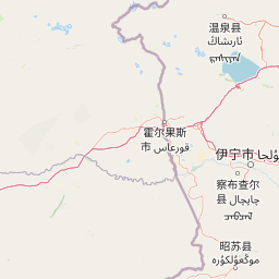
Map view of Huocheng Steppe Tortoise National Nature Reserve

Use this park location map to pinpoint Huocheng Steppe Tortoise National Nature Reserve in China, understand its exact geographic position, and read its mapped placement within the surrounding landscape more clearly.

Pigeon | © OpenStreetMap contributors

Location context for Huocheng Steppe Tortoise National Nature Reserve

Xinjiang Uyghur Autonomous Region
Park atlas

Compare adjacent Tianshan foothill environments and regional steppe habitats

Parks Near 新疆霍城四爪陆龟国家级自然保护区 and Related Protected Areas

Browsing other protected areas near 新疆霍城四爪陆龟国家级自然保护区 reveals connected ecological corridors and similar semi-arid highland terrain. Comparing these neighboring conservation zones provides deeper geographic context for the surrounding Tianshan mountain transition belt.
Nature reserveXinjiang
About 66 km away#1 closest

Southeast

新疆伊犁小叶白蜡国家级自然保护区: Regional Protected Landscape and Tianshan Mountain Geography

Conservation focus on rare riparian ash forest ecosystems in Xinjiang

Spanning the alluvial floodplains of the Kashi and Ili Rivers, this nature reserve is a scientific stronghold for the narrow-leaved ash. The protected area showcases multi-generational forest structures and diverse ancient plant lineages, shaped by a sheltered Tianshan valley microclimate that remains unusually humid for the arid landscapes of inland Xinjiang.

Area
91.03 km²
Established
1983
Relief
Mixed relief
Climate
Temperate
Nature reserveXinjiang
About 105 km away#2 closest

Northwest

Xinjiang Wenquan Xinjiang Salamander National Nature Reserve Protected Landscape and Atlas Geography

A vital montane spring and alpine grassland protected area in the Western Tianshan.

The Xinjiang Wenquan Xinjiang Salamander National Nature Reserve serves as a dedicated refuge for relict amphibian populations within the Tianshan mountain system. Its small footprint concentrates on preserving the integrity of cold-water spring brooks and snowmelt-driven seepage zones that form the backbone of this regional ecosystem. The reserve provides a clear example of targeted habitat management within the diverse topography of northwestern China.

Area
6.95 km²
Established
1997
Relief
Mountain
Climate
Arid
Watercolor painting depicting a mountain range, lake, and grassy foreground under a pale sky
National parkAlmaty Region
About 141 km away#3 closest

Northwest

Zhongar-Alatau National Park: Protected Mountain Landscape and Genetic Heritage Atlas

Almaty Region's critical wild apple forest and glaciated terrain.

Zhongar-Alatau National Park in Kazakhstan's Almaty Region is a significant protected landscape renowned for its role in conserving the genetic origins of cultivated apples. The park encompasses dramatic glaciated mountain ranges, deep canyons, and diverse ecosystems within the Dzungarian Alatau. Its mapped boundaries define an area vital for protecting unique wild fruit tree species, including the Sievers apple, and preserving the distinctive alpine terrain of southeastern Kazakhstan, offering rich context for geographic exploration.

Area
36 km²
Established
2010
IUCN
II
Relief
Mountain
Watercolor illustration showing rolling hills, distant mountains, and sparse vegetation
National parkAlmaty Region
About 152 km away#4 closest

West

Altyn-Emel National Park: A Protected Landscape of Singing Dunes and Lunar Mountains

Explore unique geological wonders and ancient Saka history.

Discover Altyn-Emel National Park, a prominent national park located in Kazakhstan's Almaty Region. This protected area showcases an extraordinary diversity of landscapes, from the echoing Singing Dunes to the otherworldly Aktau mountains, often referred to as the 'lunar mountains' due to their vivid mineral hues. As a vital conservation zone, it safeguards Central Asian steppe ecosystems and significant Iron Age archaeological sites, offering a rich tapestry of natural beauty and historical depth for atlas exploration.

Area
4,600 km²
Established
1996
IUCN
II
Relief
Mixed relief
Watercolor painting of a river landscape with green mountains, grasses, and a stream
National parkAlmaty Region
About 168 km away#5 closest

Southwest

Charyn National Park: Protected Landscape Atlas and Mapped Terrain in Almaty Region

Explore its dramatic canyons and ancient Sogdian ash groves.

Charyn National Park offers a compelling exploration of Central Asia's dramatic natural heritage, centered around its spectacular canyon system. This protected area, situated in Kazakhstan's Almaty Region, features towering red rock walls and unique geological formations carved by the Charyn River. The park is also notable for preserving one of the world's northernmost stands of ancient Sogdian ash trees, a vital link to prehistoric ecosystems. Users can discover the park's mapped boundaries, diverse terrain, and distinct landscape features, making it a key destination for geographic and atlas-based discovery.

Area
1,250 km²
Established
2004
IUCN
II
Relief
Mountain
Nature reserveGongliu County
About 173 km away#6 closest

Southeast

Xinjiang West Tianshan National Nature Reserve: Protected Landscape and Mountain Terrain Map

A high-altitude forest and mountain nature reserve in Gongliu County.

This nature reserve encompasses a vast altitudinal range and complex river drainage systems in the western Tianshan. It is defined by its deep river gorges, glaciated peaks, and ancient spruce stands, functioning as a moist island for diverse Central Asian flora and fauna within an otherwise arid regional geography.

Area
312.17 km²
Established
1983
Relief
Mountain
Climate
Temperate
A horizontal watercolor illustration showing soft green grassy foregrounds, a midground of low vegetation, and distant purple and green mountain silhouettes on a white background.
Natural monumentAlmaty Region
About 177 km away#7 closest

West

Charyn Ash Grove Natural Monument and Riparian Forest Landscape in Almaty Region

Protected botanical relic in the Kazakhstan steppe

Charyn Ash Grove preserves a rare population of river-loving Sogdian ash trees within the arid landscape of southeastern Kazakhstan. This protected natural monument traces the moisture-rich corridors of the Charyn and Temirlik rivers, creating a vivid riparian ribbon surrounded by rugged semi-desert terrain and ancient archaeological features that define the regional geography.

Area
48.55 km²
Established
1964
IUCN
III
Relief
Lowland
Nature reserveXinjiang
About 186 km away#8 closest

Northeast

新疆甘家湖梭梭林国家级自然保护区: Arid Ecosystems and Protected Haloxylon Woodland Mapping

Examining desert terrain and dune geomorphology in northwestern Xinjiang

Explore the structured geography of the Xinjiang Ganjiahu Haloxylon National Nature Reserve, which guards an expansive and ecologically critical saxaul woodland corridor. This protected area stands as a representative example of temperate desert systems in the Ebinur Basin, offering insight into wind-shaped dune landscapes, saline-alkali soil patterns, and the historic riverbeds that once connected Tien Shan meltwater to the regional basin floor.

Area
546.67 km²
Established
1983
Relief
Lowland
Climate
Arid

Common questions about visiting, size, designation, and location context for Huocheng Steppe Tortoise National Nature Reserve

Huocheng Steppe Tortoise National Nature Reserve FAQs for park facts, access, geography, and protected area context

Find quick answers about Huocheng Steppe Tortoise National Nature Reserve, including protected-area facts, park geography, trail and visitor context, and how the park fits into its surrounding country and regional landscape.
MoriAtlas Explorer

Continue Your Protected Areas Search Across the Global Atlas

Deepen your exploration by continuing the structured search for national parks and protected areas worldwide. Utilize the comprehensive filtering capabilities to compare different conservation landscapes and refine your understanding of global park geography. Discover more about the distribution and characteristics of protected natural areas.

Global natural geography