
Mori Atlas logo
Natural monumentCharyn Ash Grove

A rare riparian forest relic surviving within the arid steppe and river canyon terrain.

Charyn Ash Grove Natural Monument: Mapped Protected Landscapes in the Almaty Region of Kazakhstan

The Charyn Ash Grove stands as a significant protected natural monument located along the middle course of the Charyn River in southeastern Kazakhstan. This relict riparian woodland of Sogdian ash represents a distinct ecological pocket, flourishing in a narrow river-dependent corridor that contrasts sharply with the surrounding dry steppe and semi-desert terrain of the Almaty Region. Spanning the confluence with the Temirlik River, the protected landscape preserves both unique botanical heritage and ancient archaeological sites marked by historical burial mounds.

relict forestriparian woodlandSogdian ashnatural monumentKazakhstan protected areaCharyn River ecosystem
A flat-style vector illustration showing a winding blue river flowing through a valley surrounded by desert mesas and scattered trees.

Charyn Ash Grove

Natural monument

Park overview

Structured park overview, official facts, and landscape profile for Charyn Ash Grove

Charyn Ash Grove park facts, protected area profile, and essential visitor context

Review the core facts for Charyn Ash Grove, including designation, size, terrain, visitor scale, habitats, and operating context in one park-focused overview.

About Charyn Ash Grove

Charyn Ash Grove is a small but ecologically extraordinary protected forest that stands out sharply against the surrounding steppe and semi-desert terrain of southeastern Kazakhstan. Stretching across parts of the Sartogay tract in the Kegen district of Almaty Oblast, the grove is dominated by the Sogdian ash, a tree whose natural distribution has shrunk to fragments along the Charyn River and its tributary Temirlik. Because the species depends entirely on riverside conditions, botanists describe it as "river-loving," and its continued presence here is essentially a relic of earlier, wetter climatic periods in the region.

Although the wider Charyn area is internationally recognized for the spectacular Charyn Canyon, the ash grove has its own identity as a botanical landmark. The surrounding terrain is dry, open, and largely treeless, which makes the green corridor of ash trees that follows the river visually striking and ecologically unique. The grove also represents an important case of in situ conservation, demonstrating how even a small riparian zone can preserve a species that has practically disappeared elsewhere.

Culturally, the landscape around the grove is layered with traces of ancient human habitation. Long chains of small stone burial mounds extend for kilometers around the ash trees, and the larger Sartogay kurgans differ distinctly from burial constructions found elsewhere in the Semirechye region. This blend of botanical rarity, geological setting, and archaeological heritage gives the ash grove an unusually layered character within the Charyn National Park framework.

Protection and recognition

Terrestrial conservation framework and official designation history for Charyn Ash Grove

Charyn Ash Grove Protection Status and Documented Conservation Scope

Charyn Ash Grove maintains a documented terrestrial protection scope without imported international recognition sources. Official conservation records outline the established management framework governing this protected natural area.

Protection details

Protection scope
Terrestrial
Transboundary protection
No
Park context

Deeper park guide and search-rich context for Charyn Ash Grove

Charyn Ash Grove history, landscape, wildlife, and travel context

Explore Charyn Ash Grove through its history, landscape character, ecosystems, wildlife, conservation priorities, cultural context, and seasonal travel timing in a structured park guide built for atlas discovery and search intent.

Why Charyn Ash Grove stands out

Charyn Ash Grove is best known as a relict grove of the Sogdian ash, a tree species that botanists describe as "river-loving" because it survives only in the riverine conditions found along the Charyn River and the Temirlik canyon. Within the broader Charyn landscape, which is famous for its dramatic canyon scenery, this grove stands out as the last significant population of the species in the region and a classic example of how narrow ecological requirements can preserve living relics in unexpected places.
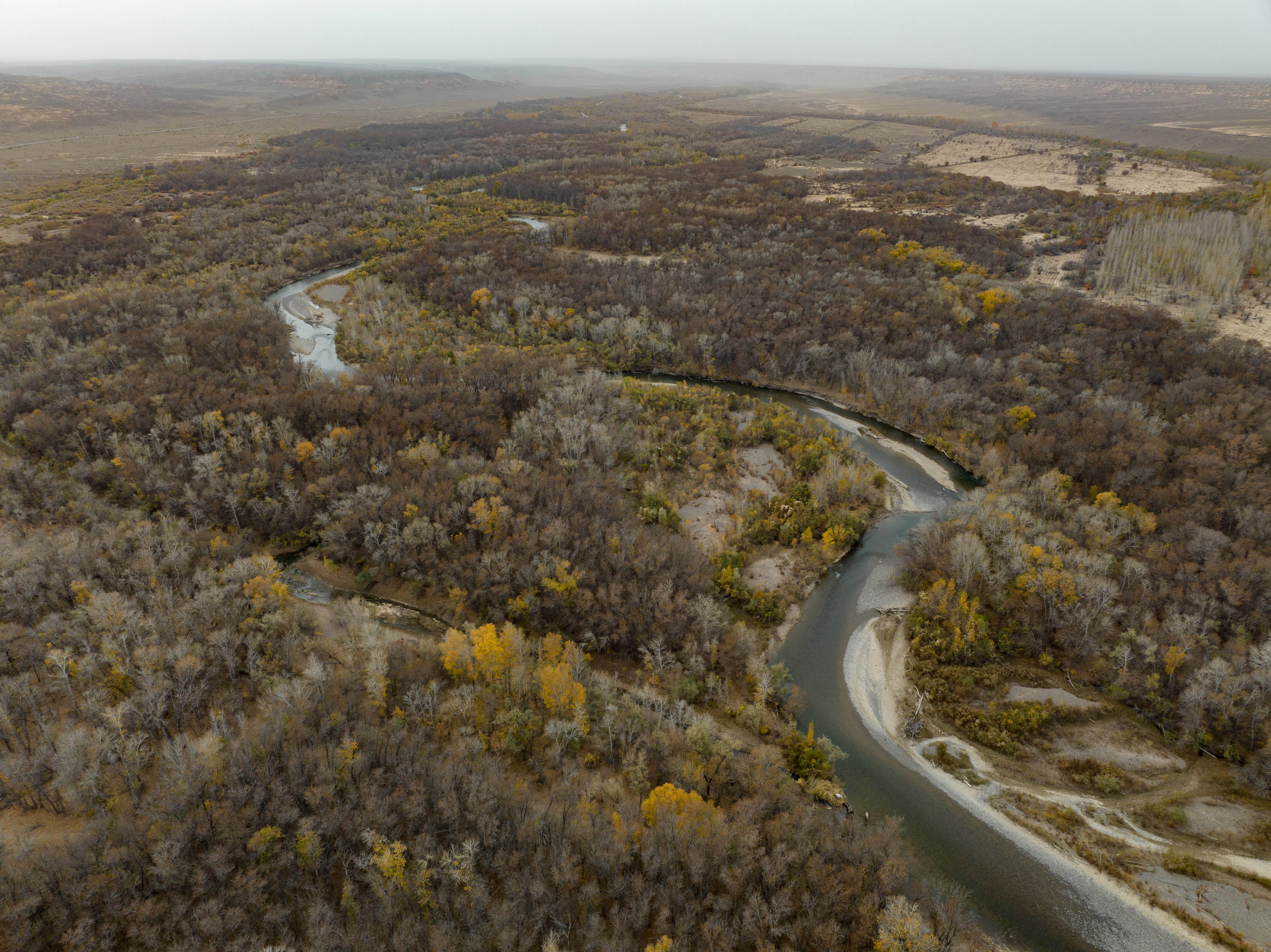
An aerial view showing a river winding through a dense forest with autumn foliage and surrounding arid, open landscape.
An aerial view of the Charyn Ash Grove, showing the meandering path of the Charyn River through the dense forest.

Charyn Ash Grove history and protected-area timeline

The Charyn Ash Grove was formally recognized as a natural monument of Kazakhstan on March 19, 1964, establishing the earliest layer of formal protection for the site. The protection order prohibited logging within the grove and restricted grazing, measures that have shaped how the forest has been managed ever since. Several forest ranger posts were established along the grove to enforce these restrictions and to guard the Sogdian ash population.

Over time, the broader Charyn area was reorganized into a larger national protected landscape through the creation of Charyn National Park, which formally encompasses the ash grove and the surrounding canyon, steppe, and river corridor. This incorporation into the national park gave the grove a more stable institutional setting, ensuring that the Sogdian ash population is preserved within a wider network of protected habitats.

The area's deeper human history extends well beyond formal protection, with the surrounding Sartogay tract dotted with hundreds of small ancient stone burial mounds, or kurgans, that suggest a long-standing human relationship with this particular riverine landscape.

Charyn Ash Grove landscape and geographic character

The landscape around Charyn Ash Grove is defined by the contrast between narrow riverside greenery and expansive dry country. The grove itself hugs the middle course of the Charyn River, where sufficient groundwater and riverbank moisture allow the Sogdian ash to root and thrive. A secondary component of the riparian landscape extends into the canyon of the Temirlik River, a tributary whose sheltered canyon environment provides similar river-loving conditions.

Around the river corridors, the terrain opens into the broader steppe and semi-desert environments typical of southeastern Kazakhstan. This dry, often rugged surrounding topography makes the strip of ash forest appear as a distinct green ribbon of vegetation within otherwise exposed country. The Sartogay area itself carries ancient topographic traces as well, with the land surface scattered with old burial mounds that mark how early inhabitants interacted with this particular landscape.

The visual texture of the region combines elements of canyon scenery, open steppe, riparian woodland, and archaeologically marked terrain, creating a setting where a relatively small forest can have outsized landscape significance.

Charyn Ash Grove ecosystems, habitats, and plant life

The defining ecological feature of Charyn Ash Grove is its concentration of the Sogdian ash, a relict tree species whose ecological requirements are tightly bound to riverbanks. Because the species survives only where sufficient groundwater, sediment conditions, and seasonal flow dynamics are present, it is described by botanists as a "river-loving" species. This dependence on riverside habitats has caused the species to retreat into fragmented populations across Central Asia, and the Charyn grove represents one of its most important surviving stands.

The grove's vegetation structure is fundamentally a riparian mosaic. Alongside the dominant Sogdian ash, the riverside zones also support other moisture-loving species, including willow, poplar, and various shrubs, which together form a narrow but relatively diverse corridor of woodland within a much drier steppe matrix. This mosaic effect reinforces the greenhouse-like character of the grove during warmer months and provides habitat continuity along the Charyn.

Ecologically, the grove is important not only for the ash population itself but also for the role it plays in maintaining a sustainable riverside habitat in a region where such woodland is scarce. It functions as a refuge, a seed source, and a structural component of the broader Charyn ecosystem, and its protection under the national park framework extends this ecological value beyond the strict boundaries of the original natural monument designation.

Charyn Ash Grove conservation status and protection priorities

Charyn Ash Grove is protected primarily as a botanical natural monument, and its conservation significance lies in the survival of an ecologically narrow relict tree species in a region where similar populations have largely disappeared. The site's designation as a natural monument in 1964 imposed some of the earliest formal restrictions on logging and grazing in the area, and these restrictions remain a central pillar of the grove's protection.

The grove's broader conservation value is amplified by its inclusion within Charyn National Park, which integrates the riparian ash zone with the surrounding canyon, steppe, and riverine landscapes. This larger framework helps buffer the grove against external pressures and supports the hydrological and ecological processes that the Sogdian ash depends on.

From a regional biodiversity standpoint, the grove is an important reference site for understanding how riparian refuges function in semi-arid Central Asia. Its continued existence demonstrates how targeted protection of a narrow ecological niche can preserve an entire species population, even when that species occupies only a small share of the national park's overall land area.

Charyn Ash Grove cultural meaning and human context

The cultural dimension of Charyn Ash Grove is closely tied to the wider Sartogay landscape. Scattered across the terrain around the forest are several hundred small stone burial mounds, or kurgans, that reflect ancient habitation of the area. The larger Sartogay kurgans differ architecturally from other burial constructions in the Semirechye region, suggesting that a distinct clan, tribe, or lineage once occupied this particular pocket of the Charyn valley.

These ancient mounds are typically framed either by wide rings of stones or by square enclosures raised as low embankments, giving the surrounding landscape a distinctive archaeological texture that contrasts with the natural forest itself. The combination of a living relict grove and a dense concentration of ancient burial architecture gives the area a layered human and ecological identity, where natural protection and cultural heritage coexist within the same protected area framework.

Top sights and standout views in Charyn Ash Grove

Charyn Ash Grove's most distinctive features include its relict population of the Sogdian ash, its strict dependence on the riverside conditions of the Charyn and Temirlik rivers, and its long-standing protection as a natural monument since 1964. The grove's visual prominence as a green ribbon within an otherwise dry steppe, combined with the dense belt of ancient Sartogay kurgans encircling the forest, gives the site an unusually rich blend of botanical and archaeological character within the Charyn National Park.
Monthly climate preview

Review measured monthly temperature averages and precipitation patterns for this protected location

Charyn Ash Grove Climate Normals and Long Term Temperature Rhythms

Long term climate data for Charyn Ash Grove records continuous shifts in monthly average temperature and precipitation rates from representative coordinate sampling. Analyzing the complete twelve month profile reveals detailed weather patterns across the protected landscape.
Annual mean10 °C
-4 °C25 °C
Jan-4°
Feb-1°
Mar
Apr11°
May17°
Jun22°
Jul25°
Aug23°
Sep17°
Oct10°
Nov
Dec-2°
Warmest month
July

24.5 °C

Coolest month
January

-3.8 °C

Wettest month
June

1.1 mm/day

Driest month
January

0.5 mm/day

Park location guide

Geography guide, regional context, and park location map for Charyn Ash Grove

Charyn Ash Grove park geography, regions, and map view in Kazakhstan

Understand where Charyn Ash Grove sits in Kazakhstan through a broader geographic reading of the surrounding landscape, nearby location context, and its mapped position within the national park landscape.

How Charyn Ash Grove fits into Kazakhstan

Kazakhstan is a Central Asian country spanning vast steppes and plains, bordered by Russia, China, Kyrgyzstan, Uzbekistan, and Turkmenistan, with a coastline along the Caspian Sea. It gained independence from the Soviet Union in 1991 and has a population of approximately 20.5 million people. The country is officially secular but predominantly Muslim, with Kazakh and Russian as official languages.

Wider geography shaping Charyn Ash Grove in Kazakhstan

Kazakhstan occupies a vast territory in Central Asia, extending into Eastern Europe. Its terrain consists largely of hilly plateaus and plains, with lowlands covering about a third of the area. The southern and eastern regions are mountainous. The country borders Russia to the north and west, China to the east, Kyrgyzstan to the southeast, Uzbekistan to the south, and Turkmenistan to the southwest. It has a coastline along the Caspian Sea.

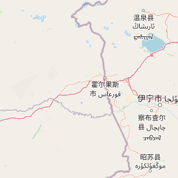
Map view of Charyn Ash Grove

Use this park location map to pinpoint Charyn Ash Grove in Kazakhstan, understand its exact geographic position, and read its mapped placement within the surrounding landscape more clearly.

Pigeon | © OpenStreetMap contributors

Location context for Charyn Ash Grove

Almaty Region

Visual exploration of riparian woodland habitats and river valley terrain

Charyn Ash Grove Photos and Landscape Scenery

Photographic records reveal the distinct contrast between lush riverside greenery and surrounding arid steppe environments. Visual documentation highlights the unique botanical character and protected natural monument landscapes preserved along the river corridor.

An aerial view showing a river winding through a dense forest with autumn foliage and surrounding arid, open landscape.

A dirt path leading into a deep canyon with towering red sandstone cliffs under a cloudy sky.

Park atlas

Compare surrounding river corridors, canyon terrain, and regional park landscapes.

Parks Near Charyn Ash Grove: Discover Other Protected Areas in the Region

Browse other parks near Charyn Ash Grove to examine connected river corridors and arid steppe environments across southeastern Kazakhstan. Comparing these protected landscapes helps contextualize rare riparian habitats within the broader regional topography.
Watercolor painting of a river landscape with green mountains, grasses, and a stream
National parkAlmaty Region
Mapped location lies within the park boundary#1 closest

Southwest

Charyn National Park: Protected Landscape Atlas and Mapped Terrain in Almaty Region

Explore its dramatic canyons and ancient Sogdian ash groves.

Charyn National Park offers a compelling exploration of Central Asia's dramatic natural heritage, centered around its spectacular canyon system. This protected area, situated in Kazakhstan's Almaty Region, features towering red rock walls and unique geological formations carved by the Charyn River. The park is also notable for preserving one of the world's northernmost stands of ancient Sogdian ash trees, a vital link to prehistoric ecosystems. Users can discover the park's mapped boundaries, diverse terrain, and distinct landscape features, making it a key destination for geographic and atlas-based discovery.

Area
1,250 km²
Established
2004
IUCN
II
Relief
Mountain
Watercolor illustration showing rolling hills, distant mountains, and sparse vegetation
National parkAlmaty Region
About 30 km away#2 closest

Northwest

Altyn-Emel National Park: A Protected Landscape of Singing Dunes and Lunar Mountains

Explore unique geological wonders and ancient Saka history.

Discover Altyn-Emel National Park, a prominent national park located in Kazakhstan's Almaty Region. This protected area showcases an extraordinary diversity of landscapes, from the echoing Singing Dunes to the otherworldly Aktau mountains, often referred to as the 'lunar mountains' due to their vivid mineral hues. As a vital conservation zone, it safeguards Central Asian steppe ecosystems and significant Iron Age archaeological sites, offering a rich tapestry of natural beauty and historical depth for atlas exploration.

Area
4,600 km²
Established
1996
IUCN
II
Relief
Mixed relief
A watercolor illustration of a rolling, grassy landscape with gentle hills and light vegetation in pastel tones.
Natural monumentAlmaty Region
About 69 km away#3 closest

Northwest

Singing Dune (Поющий бархан) Natural Monument in the Almaty Region of Kazakhstan

A stationary desert landmark within the Dzungarian Alatau foothills.

Singing Dune (Поющий бархан) is a prominent geological landmark in the Altyn-Emel National Park of the Almaty Region. This massive sand barchan, anchored between two mountain ridges, is recognized for its unique ability to produce resonant organ-like sounds. The surrounding terrain blends arid desert dunes with the striking silhouettes of the Dzungarian Alatau foothills and the distant Ili River valley.

Relief
Upland
Scope
Terrestrial
Water
Minor water
Watercolor illustration of a mountain lake with forests, distant mountains, and calm water reflecting the scenery
National parkAlmaty Region
About 88 km away#4 closest

Southwest

Kolsay Lakes National Park: Discover Protected Alpine Lakes in Almaty Region

Mapped Tian Shan mountain geography and glacial lake context.

Kolsay Lakes National Park is a significant protected area within the Almaty Region, celebrated for its breathtaking chain of three alpine lakes, often referred to as the 'Pearls of Tien Shan.' This national park showcases the rugged beauty of the Tian Shan mountains, with dramatic valleys, dense spruce forests, and pristine glacial waters. Understanding its geographic setting and mapped boundaries reveals the unique ecological and landscape value of this protected natural area.

Area
1,619 km²
Established
2007
IUCN
II
Relief
Mountain
National parkKyrgyzstan
About 159 km away#5 closest

Southwest

Karakol State Nature Park: Kyrgyzstan National Park Atlas and Mapped Protected Landscape

Explore the geographic context and mapped boundaries of this Kyrgyz national park.

Delve into Karakol State Nature Park, a designated national park contributing to Kyrgyzstan's rich protected lands catalog. This entry provides essential details for understanding its protected landscape identity, its geographic setting within the Central Asian mountains, and its mapped presence within a broader atlas of natural areas. Discover the park's unique role as a mapped conservation zone and its contribution to regional geographic context.

Area
380.95 km²
Established
1997
Relief
Mountain
Scope
Terrestrial
Watercolor painting depicting a mountain range, lake, and grassy foreground under a pale sky
National parkAlmaty Region
About 164 km away#6 closest

North

Zhongar-Alatau National Park: Protected Mountain Landscape and Genetic Heritage Atlas

Almaty Region's critical wild apple forest and glaciated terrain.

Zhongar-Alatau National Park in Kazakhstan's Almaty Region is a significant protected landscape renowned for its role in conserving the genetic origins of cultivated apples. The park encompasses dramatic glaciated mountain ranges, deep canyons, and diverse ecosystems within the Dzungarian Alatau. Its mapped boundaries define an area vital for protecting unique wild fruit tree species, including the Sievers apple, and preserving the distinctive alpine terrain of southeastern Kazakhstan, offering rich context for geographic exploration.

Area
36 km²
Established
2010
IUCN
II
Relief
Mountain
State or regional parkKyrgyzstan
About 166 km away#7 closest

South

Khan-Tengri State Nature Park: Kyrgyzstan State or Regional Park Atlas Exploration

Explore protected landscapes and geographic context.

Khan-Tengri State Nature Park is a designated protected area in Kyrgyzstan, offering unique insights into the region's mountainous geography. This page serves as a detailed atlas entry, highlighting the park's protected landscape characteristics, its mapped boundaries, and its place within the broader natural terrain of Central Asia. Understand the geographic identity of this state or regional park and its contribution to conservation landscapes.

Area
2,758 km²
Established
2016
Relief
Mountain
Access
Remote access
Nature reserveXinjiang
About 171 km away#8 closest

Northeast

Xinjiang Wenquan Xinjiang Salamander National Nature Reserve Protected Landscape and Atlas Geography

A vital montane spring and alpine grassland protected area in the Western Tianshan.

The Xinjiang Wenquan Xinjiang Salamander National Nature Reserve serves as a dedicated refuge for relict amphibian populations within the Tianshan mountain system. Its small footprint concentrates on preserving the integrity of cold-water spring brooks and snowmelt-driven seepage zones that form the backbone of this regional ecosystem. The reserve provides a clear example of targeted habitat management within the diverse topography of northwestern China.

Area
6.95 km²
Established
1997
Relief
Mountain
Climate
Arid

Common questions about visiting, size, designation, and location context for Charyn Ash Grove

Charyn Ash Grove FAQs for park facts, access, geography, and protected area context

Find quick answers about Charyn Ash Grove, including protected-area facts, park geography, trail and visitor context, and how the park fits into its surrounding country and regional landscape.
MoriAtlas Explorer

Continue Your Protected Areas Search Across the Global Atlas

Deepen your exploration by continuing the structured search for national parks and protected areas worldwide. Utilize the comprehensive filtering capabilities to compare different conservation landscapes and refine your understanding of global park geography. Discover more about the distribution and characteristics of protected natural areas.

Global natural geography