Mori Atlas logo
National parkZhongar-Alatau National Park

Explore the Dzungarian Alatau's glaciated mountains and critical wild apple genetic heritage.

Zhongar-Alatau National Park: Discover Its Protected Landscape and Geographic Context

Zhongar-Alatau National Park represents a critical protected landscape within Kazakhstan's Almaty Region, established to conserve the Dzungarian Alatau mountain range's unique ecological systems. This national park safeguards vast tracts of glaciated terrain, steep canyons, and crucial wild fruit tree forests, notably the Sievers apple, the progenitor of all cultivated apples. Its geographic position between the Tian Shan and Altai mountains makes it a focal point for biodiversity and a significant entity within any regional atlas.

National ParkKazakhstanDzungarian AlatauWild AppleGenetic ConservationGlaciated Mountains
Stylized illustration of a waterfall flowing into a lake, surrounded by mountains, trees, and rocks

Zhongar-Alatau National Park

National park

Park overview

Structured park overview, official facts, and landscape profile for Zhongar-Alatau National Park

Zhongar-Alatau National Park park facts, protected area profile, and essential visitor context
Review the core facts for Zhongar-Alatau National Park, including designation, size, terrain, visitor scale, habitats, and operating context in one park-focused overview.

About Zhongar-Alatau National Park

Zhongar-Alatau National Park was established in April 2010 to protect the extraordinary ecology of the Dzungarian Alatau, a mountain range that forms a natural bridge between the Tian Shan system to the south and the Altai Mountains to the north. This positioning at a climatic and geographic crossroads has produced remarkable biodiversity, with the park ranking second only to the Altai region in Kazakhstan for the number of plant and animal species present. The park stretches approximately 300 kilometers in a west-to-east direction across three districts of Almaty Region, covering terrain that ascends from semi-desert foothills through forested slopes to alpine meadows and permanent ice. The creation of the park was driven by recognition that the Dzungarian Alatau contains globally important genetic resources in the form of wild fruit tree forests, particularly the Sievers apple, whose descendants now constitute the entire global orchard apple industry. Environmental education and tourism infrastructure are under development, with seven tourist routes currently available for visitors interested in the park's historical sites, glacial features, wild apple groves, and forest ecosystems.

Quick facts and research context for Zhongar-Alatau National Park

Zhongar-Alatau National Park lies in the Dzungarian Alatau, an isolated mountain range at the junction of several geographic and climatic regions. The park occupies the northern slope of this range, where two major rivers—the Aksu and Lepsy—originate and flow northward into Lake Balkhash. The region is recognized as Kazakhstan's second most biodiverse area after the Altai, owing to its position at the meeting point of boreal, steppe, and desert ecological zones. Altitude zones range from desert and grassland at lower elevations through shrubland and forest to alpine meadows and permanent glaciers at the highest points. The park contains approximately 2,168 species of vascular plants, of which 76 are endemic to the region. The area is administered by the Forestry and Wildlife Committee of Kazakhstan's Ministry of Ecology, Geology and Natural Resources.

Park context

Deeper park guide and search-rich context for Zhongar-Alatau National Park

Zhongar-Alatau National Park history, landscape, wildlife, and travel context
Explore Zhongar-Alatau National Park through its history, landscape character, ecosystems, wildlife, conservation priorities, cultural context, and seasonal travel timing in a structured park guide built for atlas discovery and search intent.

Why Zhongar-Alatau National Park stands out

Zhongar-Alatau is best known for its wild Sievers apple trees (Malus sieversii), which grow in scattered stands across roughly 1% of the park's area. These wild apple populations are considered the progenitors of all cultivated apple varieties grown worldwide today, making this one of the most genetically significant forest ecosystems on the planet. Beyond the apple groves, the park protects extensive apricot, barberry, cherry, and currant thickets that form a unique wild fruit tree ecosystem. The dramatic glaciated mountain scenery, deep canyons, glacial valleys, and alpine peaks, provides the visual backdrop for this remarkable botanical heritage.

Calm lake with light blue water reflecting sky and clouds, bordered by green forested hills and rocky formations under a partly cloudy sky.
Zhasylkol Lake within Zhongar-Alatau National Park, surrounded by forested hills and rocky outcrops.

Zhongar-Alatau National Park history and protected-area timeline

Zhongar-Alatau National Park was officially established on April 30, 2010, through a decree of the Government of Kazakhstan. The park was created specifically to protect the unique ecology of the Dzungarian Alatau mountain range and its remarkable wild fruit tree forests. The establishment reflected growing recognition of the global significance of the region's genetic resources, particularly the wild apple populations that serve as the ancestral source of cultivated apple varieties. The park was placed under the management of the Forestry and Wildlife Committee, which operates under the Ministry of Ecology, Geology and Natural Resources of Kazakhstan. The selection of this area for national park status also reflected its ecological position as a critical transition zone where multiple biogeographic regions meet, creating exceptional species diversity.

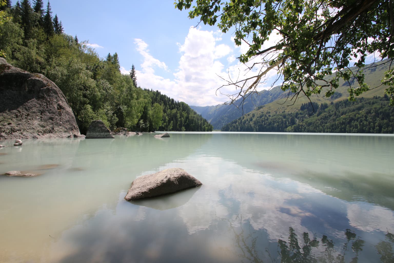
Zhongar-Alatau National Park landscape and geographic character

The park occupies the northern slope of the Dzungarian Alatau, a mountain range characterized by steep, rocky canyons and rapid-flowing streams descending from glacial source areas. The terrain is dominated by two parallel mountain ridges—the Northern and Southern Dzungarian Alatau—separated by the Koksu River valley. The highest peaks reach elevations exceeding 4,600 meters, with Besbakan at 4,622 meters being the tallest point in the Northern ridge. The landscape displays classic alpine topography with cirques, U-shaped glacial valleys, and sharp ridgelines. Two major river systems originate within the park: the Aksu River and the Lepsy River, both flowing northward across the foothills before emptying into Lake Balkhash. Extensive glaciation characterizes the higher elevations, with numerous glaciers descending from the permanent snowfield zones.

Zhongar-Alatau National Park ecosystems, habitats, and plant life

The Dzungarian Alatau sits at a critical ecological crossroads where boreal, steppe, and desert biogeographic regions converge, creating extraordinary habitat diversity within a relatively compact area. The park's altitude zones span from desert and semi-desert at the lowest elevations through grassland, shrubland, and forest to subalpine and alpine meadows and finally to permanent glaciers. This vertical stratification supports remarkable plant diversity, with 2,168 species of vascular plants documented across 112 families and 622 genera. Approximately 76 species are endemic to the region, found nowhere else on Earth. The forest cover is dominated by pine and spruce at mid-elevations, but the most distinctive feature is the scattered stands of wild fruit trees—most notably the Sievers apple (Malus sieversii)—that represent the wild ancestor of all cultivated apple varieties. Wild apricot, barberry, cherry, and currant thickets also occur throughout the park.

Zhongar-Alatau National Park wildlife and species highlights

The Dzungarian Alatau supports a rich fauna that reflects its position at the overlap zone between Siberian and Tian Shan wildlife communities. The park's mammal population includes snow leopards, which have been recorded in the area in recent years, as well as populations of deer, brown bear, and various mountain ungulates. The diverse habitats created by the park's vertical zonation—from forest through alpine meadows to glacial terrain—support both species adapted to different elevation zones and those that move seasonally between them. Birdlife includes species typical of both northern and central Asian mountain environments.

Zhongar-Alatau National Park conservation status and protection priorities

Zhongar-Alatau National Park holds exceptional conservation significance both within Kazakhstan and globally. The primary conservation priority is the protection of wild fruit tree genetic resources, particularly the Sievers apple populations that represent the direct ancestors of all cultivated apple varieties worldwide. Approximately 1% of the park's area is covered by Sievers apple stands, making this one of the most important locations for apple genetic diversity on the planet. The park also protects a critical biodiversity hotspot, as the Dzungarian Alatau ranks second only to the Altai region in Kazakhstan for biological diversity. The combination of high endemism, globally significant genetic resources, and the meeting point of multiple biogeographic regions makes this area a priority for long-term conservation. The park's designation as IUCN Category II reflects its primary mandate of protecting natural ecosystems while allowing for sustainable environmental education and tourism.

Zhongar-Alatau National Park cultural meaning and human context

The Dzungarian Alatau has historically served as a mountainous corridor and border zone between Kazakhstan and China. The region has been inhabited by pastoral communities who have traditionally utilized the mountain pastures for seasonal livestock grazing. The Kazakh-language name for the park—Жоңғар Алатауы ұлттық паркі—reflects the local identity and ownership of this protected landscape. While the park itself does not contain major archaeological sites, the broader Dzungarian Alatau region includes historical sites related to the ancient Silk Road routes that passed through the mountain passes.

Top sights and standout views in Zhongar-Alatau National Park

The park protects the world's most important wild apple genetic resource—the Sievers apple stands that are the direct ancestors of all cultivated apple varieties. The Dzungarian Alatau mountain range provides dramatic glaciated scenery with peaks exceeding 4,600 meters, extensive glacier systems, and deep alpine valleys. The biodiversity is exceptional, with over 2,000 plant species including 76 endemics, ranking second only to the Altai region in Kazakhstan. The location at the crossroads of major biogeographic regions creates habitat diversity from desert through forest to alpine meadows. Snow leopards have been documented in the park, adding to its conservation credentials.

Best time to visit Zhongar-Alatau National Park

The park experiences a cold semi-arid climate typical of central Asian mountain environments. Summer months from June through August offer the most accessible conditions for hiking and exploration, with average temperatures reaching around 25°C in the lower elevations. Higher elevations remain significantly cooler. Spring and early summer bring more robust water flow in the mountain streams, while autumn offers the opportunity to observe the wild fruit trees in their seasonal coloration. Winter visits are possible but should only be undertaken by those prepared for severe cold, as temperatures at higher elevations can drop dramatically below freezing.

Park location guide

Geography guide, regional context, and park location map for Zhongar-Alatau National Park

Zhongar-Alatau National Park park geography, regions, and map view in Kazakhstan
Understand where Zhongar-Alatau National Park sits in Kazakhstan through a broader geographic reading of the surrounding landscape, nearby location context, and its mapped position within the national park landscape.

How Zhongar-Alatau National Park fits into Kazakhstan

Kazakhstan is a Central Asian country spanning vast steppes and plains, bordered by Russia, China, Kyrgyzstan, Uzbekistan, and Turkmenistan, with a coastline along the Caspian Sea. It gained independence from the Soviet Union in 1991 and has a population of approximately 20.5 million people. The country is officially secular but predominantly Muslim, with Kazakh and Russian as official languages.

Wider geography shaping Zhongar-Alatau National Park in Kazakhstan

Kazakhstan occupies a vast territory in Central Asia, extending into Eastern Europe. Its terrain consists largely of hilly plateaus and plains, with lowlands covering about a third of the area. The southern and eastern regions are mountainous. The country borders Russia to the north and west, China to the east, Kyrgyzstan to the southeast, Uzbekistan to the south, and Turkmenistan to the southwest. It has a coastline along the Caspian Sea.

Map view of Zhongar-Alatau National Park

Use this park location map to pinpoint Zhongar-Alatau National Park in Kazakhstan, understand its exact geographic position, and read its mapped placement within the surrounding landscape more clearly.

Pigeon | © OpenStreetMap contributors

Location context for Zhongar-Alatau National Park

Almaty Region

Visual Guide to the Dzungarian Alatau's Unique Alpine Ecosystems and Protected Botanical Heritage

Zhongar-Alatau National Park Photos: Explore Glaciated Mountain Landscapes and Wild Apple Forests
Visually explore the dramatic glaciated mountain scenery and unique protected habitats of Zhongar-Alatau National Park. This gallery provides crucial context for understanding the park's diverse terrain, from high alpine peaks and deep canyons to genetically significant wild apple forests and river valleys, offering an essential complement to geographic data and atlas insights.

Calm lake with light blue water reflecting sky and clouds, bordered by green forested hills and rocky formations under a partly cloudy sky.

Wide view of forested mountain slopes with varying vegetation and terrain

Park atlas

Trace the Dzungarian Alatau's protected landscapes and compare nearby mountain parks in Central Asia

Explore Other National Parks and Protected Areas Near Zhongar-Alatau National Park
Browse national parks and protected areas geographically situated near Zhongar-Alatau National Park, tracing connected mountain ranges and unique wild fruit tree ecosystems. This expanded view helps map the regional spread of protected landscapes, offering crucial context for comparative exploration of Central Asian conservation efforts.
Watercolor illustration showing rolling hills, distant mountains, and sparse vegetation
National parkAlmaty Region

Altyn-Emel National Park: A Protected Landscape of Singing Dunes and Lunar Mountains

Explore unique geological wonders and ancient Saka history.

Discover Altyn-Emel National Park, a prominent national park located in Kazakhstan's Almaty Region. This protected area showcases an extraordinary diversity of landscapes, from the echoing Singing Dunes to the otherworldly Aktau mountains, often referred to as the 'lunar mountains' due to their vivid mineral hues. As a vital conservation zone, it safeguards Central Asian steppe ecosystems and significant Iron Age archaeological sites, offering a rich tapestry of natural beauty and historical depth for atlas exploration.

Area
4,600 km²
Established
1996
IUCN
II
Relief
Mixed relief
Watercolor painting of a river landscape with green mountains, grasses, and a stream
National parkAlmaty Region

Charyn National Park: Protected Landscape Atlas and Mapped Terrain in Almaty Region

Explore its dramatic canyons and ancient Sogdian ash groves.

Charyn National Park offers a compelling exploration of Central Asia's dramatic natural heritage, centered around its spectacular canyon system. This protected area, situated in Kazakhstan's Almaty Region, features towering red rock walls and unique geological formations carved by the Charyn River. The park is also notable for preserving one of the world's northernmost stands of ancient Sogdian ash trees, a vital link to prehistoric ecosystems. Users can discover the park's mapped boundaries, diverse terrain, and distinct landscape features, making it a key destination for geographic and atlas-based discovery.

Area
1,250 km²
Established
2004
Relief
Mountain
Climate
Arid
Watercolor illustration of a mountain lake with forests, distant mountains, and calm water reflecting the scenery
National parkAlmaty Region

Kolsay Lakes National Park: Discover Protected Alpine Lakes in Almaty Region

Mapped Tian Shan mountain geography and glacial lake context.

Kolsay Lakes National Park is a significant protected area within the Almaty Region, celebrated for its breathtaking chain of three alpine lakes, often referred to as the 'Pearls of Tien Shan.' This national park showcases the rugged beauty of the Tian Shan mountains, with dramatic valleys, dense spruce forests, and pristine glacial waters. Understanding its geographic setting and mapped boundaries reveals the unique ecological and landscape value of this protected natural area.

Area
1,619 km²
Established
2007
IUCN
II
Relief
Mountain
National parkEast Kazakhstan Region

Tarbagatai National Park: Protected Landscape and Wild Fruit Tree Forests in East Kazakhstan Region

Explore the mapped boundaries and ecosystem of this national park.

Tarbagatai National Park is a protected area in East Kazakhstan recognized for its unique role in conserving wild fruit tree forests that have maintained genetic isolation. This national park provides a detailed view of a mountain-steppe ecosystem across the Tarbagatai mountain range, Karabas Mountains, and Arkaly Mountains, along with the Urzhar and Emel river valleys. Its establishment in 2018 highlights its importance for biodiversity and the study of natural forest genetics, offering significant geographic context for regional protected land exploration.

Area
1,364 km²
Established
2018
IUCN
II
Relief
Mountain
Watercolor painting of a river, hills, and trees with pink and yellow sky tones
National parkAlmaty Region

Ile-Alatau National Park: Protected Landscape Atlas and Almaty Region Geography

Mapped boundaries, diverse ecosystems, and mountain wilderness.

Ile-Alatau National Park is a key protected area in the Almaty Region of Kazakhstan, preserving a vast expanse of the Tian Shan mountain system. This national park showcases a dramatic vertical landscape, encompassing everything from lowland woodlands and relict spruce forests to expansive alpine meadows and glacial terrains. Its mapped boundaries define critical habitat for diverse wildlife and offer a profound insight into the complex ecological dynamics of high-altitude environments, making it an essential destination for atlas-based geographic discovery.

Area
2,000 km²
Established
1996
Relief
Mixed relief
Climate
Alpine
Watercolor illustration of a mountainous landscape with green hills, trees, and a river in the foreground
National parkKazakhstan

Karkaraly State National Nature Park: Kazakhstan's Mountain-Forest Protected Area

Discover unique geology, archaeology, and regional landscape context.

Delve into the distinctive protected landscape of Karkaraly State National Nature Park, situated in Kazakhstan's Karaganda Region. This park preserves a rare mountain-forest ecosystem with dramatic granite formations, ancient archaeological sites, and lakes, presenting a rich geographic contrast to the surrounding Kazakh Steppe. MoriAtlas provides structured insights into Karkaraly State National Nature Park's unique terrain, its conservation value, and its position within the broader regional geography of Central Asia.

Area
1,121.2 km²
Established
1998
IUCN
II
Relief
Mountain
National parkEast Kazakhstan Region

Katon-Karagay National Park: Discover Kazakhstan's Largest Protected Mountain Landscape

Explore the geography and park boundaries of East Kazakhstan's premier national park.

Katon-Karagay National Park, the largest national park in Kazakhstan, offers a deep dive into the protected landscapes of the Southern Altai Mountains. This page provides essential geographic context, detailing the park's terrain, its significance as a protected area within East Kazakhstan Region, and its role in mapping the natural contours of this ecologically diverse mountain system. Understand the park's boundaries and its contribution to regional conservation.

Area
6,435 km²
Established
2001
IUCN
II
Relief
Mountain
National parkKazakhstan

Bayanaul National Park: Kazakhstan's First National Park Mapped Landscape

Explore granite mountains, unique lakes, and striking rock formations.

Bayanaul National Park, situated in Kazakhstan's Pavlodar Province, represents a significant protected area renowned for its extraordinary granite mountain landscape. Established as the country's first national park, it showcases unique erosion-shaped rock formations, diverse vegetation including rare pines, and four significant freshwater lakes. This park offers a distinct visual tapestry of mountainous terrain and geological wonders within the broader Central Asian geography, making it a key destination for atlas-based discovery.

Area
684.53 km²
Established
1985
IUCN
II

Common questions about visiting, size, designation, and location context for Zhongar-Alatau National Park

Zhongar-Alatau National Park FAQs for park facts, access, geography, and protected area context
Find quick answers about Zhongar-Alatau National Park, including protected-area facts, park geography, trail and visitor context, and how the park fits into its surrounding country and regional landscape.
MoriAtlas Explorer

Continue Your Protected Areas Search Across the Global Atlas

Deepen your exploration by continuing the structured search for national parks and protected areas worldwide. Utilize the comprehensive filtering capabilities to compare different conservation landscapes and refine your understanding of global park geography. Discover more about the distribution and characteristics of protected natural areas.

Global natural geography