Mori Atlas logo
National parkIle-Alatau National Park

Discover mapped boundaries and diverse ecosystems in this Almaty Region national park.

Ile-Alatau National Park: Protected Landscape and Tian Shan Mountain Geography

(Ile-Alatau State National Nature Park)

Ile-Alatau National Park, situated in Kazakhstan's Almaty Region, represents a significant protected area within the Trans-Ili Alatau subrange of the Tian Shan mountains. Spanning approximately 200,000 hectares, this national park preserves a remarkable vertical landscape, from foothills and dense spruce forests to alpine meadows and high-altitude glacial terrains. Its mapped geography offers a unique opportunity to explore distinct ecological zones and understand the conservation value of this vital mountain wilderness.

National ParkKazakhstanTian Shan MountainsSnow Leopard HabitatAlpine MeadowsGlacial Lakes
Illustration of green mountains, winding river, forested area, and small tower structure under yellow sky with clouds

Ile-Alatau National Park

National park

Park overview

Structured park overview, official facts, and landscape profile for Ile-Alatau National Park

Ile-Alatau National Park park facts, protected area profile, and essential visitor context
Review the core facts for Ile-Alatau National Park, including designation, size, terrain, visitor scale, habitats, and operating context in one park-focused overview.

About Ile-Alatau National Park

Ile-Alatau State National Nature Park occupies a strategically important position along the northern edge of the Tian Shan mountains, where moisture-carrying air masses from the north and northwest encounter the mountain barrier, creating pronounced ecological differentiation across elevation zones. The park's territory stretches approximately 120 kilometers east to west and 30 to 35 kilometers north to south, encompassing four major forest areas: Aksay, Medeu, Talgar, and Turgen. This mountainous landscape features diverse terrain including deep river gorges, glacial valleys, alpine meadows, and permanent snowfields. The park shares a boundary with the Almaty Nature Reserve, which protects the area around Pik Talgar, creating a contiguous protected landscape that extends into the higher Tian Shan. The park's proximity to Almaty—Kazakhstan's commercial capital with a population exceeding two million—makes it an accessible wilderness experience for both domestic and international visitors, while the protected status ensures long-term conservation of these unique mountain ecosystems.

Quick facts and research context for Ile-Alatau National Park

Ile-Alatau National Park covers roughly 200,000 hectares along the Tian Shan foothills south of Almaty, Kazakhstan. The protected area was formally established in 1996 through governmental resolution, though conservation activity in the region dates to the 1931 creation of the Almaty State Reserve. The park encompasses elevations from 600 meters to 4,540 meters at Constitution Peak, with the Dmitriev glacier spanning 17 square kilometers as the largest ice mass. Big Almaty Lake sits at 2,500 meters elevation with a surface area of one square kilometer and maximum depth of 39.3 meters. The park contains over 1,000 plant species and 245 vertebrate species, with 36 plant species and numerous animal species listed in Kazakhstan's Red Book of protected species.

Park context

Deeper park guide and search-rich context for Ile-Alatau National Park

Ile-Alatau National Park history, landscape, wildlife, and travel context
Explore Ile-Alatau National Park through its history, landscape character, ecosystems, wildlife, conservation priorities, cultural context, and seasonal travel timing in a structured park guide built for atlas discovery and search intent.

Why Ile-Alatau National Park stands out

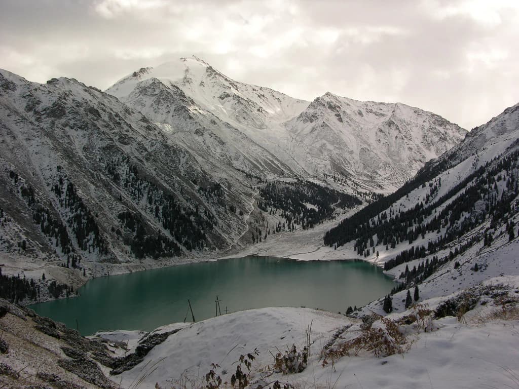
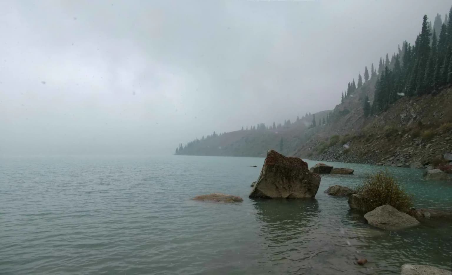
Ile-Alatau is best known for its snow leopard population and other charismatic megafauna including Central Asian lynx, Tian Shan brown bears, and Siberian ibexes. The park protects critical habitat for these threatened species within one of the most accessible mountain wilderness areas near a major Central Asian city. Big Almaty Lake, with its striking turquoise waters set against glacial backdrops, represents one of the park's most recognizable natural landmarks. The transect from lowland woodland through coniferous forest to alpine meadows and glaciers offers remarkable ecological diversity within a relatively compact area, making the park a living laboratory for understanding Tian Shan ecosystem dynamics.

Panoramic view of mountain ranges, coniferous trees, and open meadows under a clear blue sky
Panoramic landscape view of mountains and forested terrain in Ile-Alatau National Park

Ile-Alatau National Park history and protected-area timeline

Conservation history in the Ile-Alatau region began with the establishment of the Almaty State Reserve in 1931, initially covering 15,000 hectares in the Malaya Almatinka river valley. The protected area expanded significantly over subsequent decades—reaching 40,000 hectares in 1935 and eventually growing to encompass the entire Zailiisky Alatau ridge at 856,700 hectares under the Alma-Ata designation. Regular scientific research on vegetation cover, forest typology, birds, and mammals commenced during this period. The formal proposal for creating Zailiisky National Park emerged from scientific work by order of the Council of Ministers of the Kazakh SSR in January 1985, with academic supervisors E. V. Gvozdev and B. A. Bykov leading the initiative. A comprehensive development scheme prepared in 1987 proposed a 280,000-hectare national park, with implementation planned for 1995. Following a feasibility study in 1990, Ile-Alatau National Park was officially established on February 22, 1996, through governmental resolution, covering 202,292 hectares of mountain terrain.

Ile-Alatau National Park landscape and geographic character

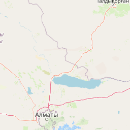
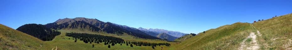
The physical landscape of Ile-Alatau National Park spans multiple distinct zones defined by elevation and topography. The low-mountain zone features deciduous woodlands and steppe communities on mountain slopes. The mid-mountain forest belt contains extensive spruce forests, particularly notable in the Chinturgen area where relict mossy spruce forests preserve islands of permafrost with ice thickness of two to three meters beneath moss cover at depths of 30 to 40 centimeters—a unique feature not found at such low altitudes elsewhere in the Trans-Ili Alatau. Alpine and subalpine meadows occupy higher elevations, giving way to permanent snow and glaciers above approximately 3,000 meters. The park contains numerous glacial lakes, with Big Almaty Lake being the most prominent. River systems including the Turgen, Esik, Talgar, Kishi Almaty, Ulken Almaty, Kargaly, and Kaskelen traverse the park, originating from glacial and snowmelt sources. The high-altitude landscape near Prokhodnoy Pass resembles the cold desert environment of the Inner Tian Shan, representing a unique ecosystem type within the park's boundaries.

Snow-covered mountain peaks, a valley with a lake, and a dirt road in Ile-Alatau National Park
Panoramic view of snow-capped mountains, a valley with a lake, and an unnamed dirt road in Ile-Alatau National Park

Ile-Alatau National Park ecosystems, habitats, and plant life

The ecological character of Ile-Alatau reflects the park's extraordinary altitudinal range and position at the interface between northern moisture-bearing systems and the Tian Shan highlands. The flora comprises more than 1,000 species, with over 500 species in deciduous forest communities and more than 400 species in spruce forest ecosystems. Thirty-six plant species are protected under Kazakhstan's Red Book, including the red-listed Crocus alatavicus found in the Kok-Gailau tract. The vegetation includes economically and ecologically significant species: apricot and apple trees representing wild fruit progenitors, diverse medicinal plants such as fir, yarrow, and rose hips, and ornamental flowers including primroses, tulips, irises, and gentians. The forest composition transitions with elevation from deciduous woodlands through coniferous spruce forests to alpine meadow communities, each supporting distinct ecological assemblages. The moisture gradient created by the mountains' barrier effect produces lush conditions in the middle and high mountains despite the surrounding arid context of Kazakhstan.

Wooden watchtower on stilts in the middle of a blue lake with surrounding mountain reflections
Wooden watchtower on stilts in the middle of Big Almaty Lake with mountain reflections

Ile-Alatau National Park wildlife and species highlights

The vertebrate fauna of Ile-Alatau includes 245 species across diverse taxonomic groups, supported by the variety of habitats from river valleys through forests to alpine zones. Mammals total 48 species, with the snow leopard representing the most ecologically significant predator—a species listed in the Red Book of Kazakhstan alongside the Central Asian lynx, Turkestan lynx, and Pallas' cat. Tian Shan brown bears occupy the higher terrain, while Siberian ibexes navigate the rocky cliff environments. Stone martens and the red-listed Central Asian river otter represent additional protected mammal species. Bird diversity is particularly notable at 178 species, including 105 nesting species, 18 wintering species, and 55 migratory species. Eleven bird species appear in the Red Book, with the black stork, pygmy eagle, golden eagle, saker falcon, and eagle owl among the most significant. The park also protects eight fish species in mountain rivers and streams, including acclimatized rainbow trout in the Turgen river, along with four amphibian species and eight reptile species.

Panoramic view of Kok-Zhaiylau mountain range with green valleys and clear blue sky
Panorama of Kok-Zhaiylau

Ile-Alatau National Park conservation status and protection priorities

Ile-Alatau National Park serves as a critical conservation node within Kazakhstan's protected area network, safeguarding representative examples of Tian Shan mountain ecosystems and their associated biodiversity. The park's protected status and Red Book designations for numerous species reflect its significance for conservation of snow leopards, Central Asian lynx, and other threatened mountain mammals. The presence of relict spruce forests with permafrost features represents unique ecological conditions requiring protection, while the diverse elevation gradient ensures representation of multiple habitat types. The boundary with the Almaty Nature Reserve creates a contiguous protected landscape that extends conservation protection beyond the park's borders. IUCN categorizes the park as Category II, recognizing its national park status and primary objective of ecosystem conservation alongside opportunities for environmental education and compatible recreation.

Ile-Alatau National Park cultural meaning and human context

The Ile-Alatau region contains evidence of human activity spanning multiple historical periods. Archaeological sites within the park include burial mounds from the early Iron Age on the Assy plateau and near the Turgen Gorge, as well as Sak-era burial sites along the banks of the Issyk River. The Talgyz and Turgen ancient settlement sites preserve traces of historical human occupation. These archaeological features indicate long-term human interaction with the mountain landscape, though the park's contemporary management focuses primarily on ecological conservation rather than cultural heritage interpretation.

Snow-covered mountain range with a turquoise lake in a valley under an overcast sky
Snow-capped mountains surrounding a turquoise lake in Ile-Alatau National Park

Top sights and standout views in Ile-Alatau National Park

Ile-Alatau combines accessibility from Almaty with remarkable ecological diversity, making it one of Kazakhstan's most visited protected areas. The snow leopard population represents a flagship conservation asset, drawing scientific interest and supporting the park's ecological reputation. Big Almaty Lake offers a visually striking destination where turquoise glacial waters reflect the surrounding peaks. The vertical ecological gradient from 600 to 4,540 meters provides an condensed illustration of Tian Shan ecosystem complexity within a single protected area. The relict Chinturgen spruce forests with their subsurface permafrost represent unusual ecological phenomena. The park protects 36 Red Book plant species and numerous threatened animals, establishing its significance for biodiversity conservation in Central Asia.

Calm lake water with large rocks in the foreground, a forested mountain slope in the background, and foggy sky
Big Almaty Lake under overcast skies with rocky shoreline and forested hills

Best time to visit Ile-Alatau National Park

The park can be visited year-round, with each season offering distinct experiences. Summer months (June through August) bring warm conditions in the foothills and provide the most accessible period for hiking and wildlife observation in the higher terrain. Spring and early summer showcase alpine meadows in flower, while autumn offers golden forest colors in the middle elevations. Winter reveals a different character of the landscape, with snow-covered peaks and frozen lakes providing photographic opportunities, though access to higher elevations becomes more restricted. The variation in climate with elevation means that conditions differ substantially between the foothills and high mountain zones, allowing visitors to experience multiple environments during a single visit.

Park location guide

Geography guide, regional context, and park location map for Ile-Alatau National Park

Ile-Alatau National Park park geography, regions, and map view in Kazakhstan
Understand where Ile-Alatau National Park sits in Kazakhstan through a broader geographic reading of the surrounding landscape, nearby location context, and its mapped position within the national park landscape.

How Ile-Alatau National Park fits into Kazakhstan

Kazakhstan is a Central Asian country spanning vast steppes and plains, bordered by Russia, China, Kyrgyzstan, Uzbekistan, and Turkmenistan, with a coastline along the Caspian Sea. It gained independence from the Soviet Union in 1991 and has a population of approximately 20.5 million people. The country is officially secular but predominantly Muslim, with Kazakh and Russian as official languages.

Wider geography shaping Ile-Alatau National Park in Kazakhstan

Kazakhstan occupies a vast territory in Central Asia, extending into Eastern Europe. Its terrain consists largely of hilly plateaus and plains, with lowlands covering about a third of the area. The southern and eastern regions are mountainous. The country borders Russia to the north and west, China to the east, Kyrgyzstan to the southeast, Uzbekistan to the south, and Turkmenistan to the southwest. It has a coastline along the Caspian Sea.

Map view of Ile-Alatau National Park

Use this park location map to pinpoint Ile-Alatau National Park in Kazakhstan, understand its exact geographic position, and read its mapped placement within the surrounding landscape more clearly.

Pigeon | © OpenStreetMap contributors

Location context for Ile-Alatau National Park

Almaty Region

A Visual Atlas to the Protected Habitats, Glacial Lakes, and Diverse Terrain of Kazakhstan's Iconic National Park

Ile-Alatau National Park Photos: Explore Tian Shan Mountain Landscapes and Alpine Scenery
Discover the captivating visual identity of Ile-Alatau National Park through a curated gallery, revealing its dramatic Tian Shan mountainscapes, unique spruce forests, and high-altitude ecosystems. These detailed park images offer a comprehensive overview of the protected area's varied terrain, providing crucial insights into its conservation value and diverse wildlife habitats.

Panoramic view of mountain ranges, coniferous trees, and open meadows under a clear blue sky

Big Almaty Lake with snow-capped mountain peak, green hills, and utility poles in foreground

Snow-covered mountain peaks, a valley with a lake, and a dirt road in Ile-Alatau National Park

Wooden watchtower on stilts in the middle of a blue lake with surrounding mountain reflections

Panoramic view of Kok-Zhaiylau mountain range with green valleys and clear blue sky

Wildflowers and grasses on a rocky trail with a mountain peak in the background

Snow-covered mountain range with a turquoise lake in a valley under an overcast sky

Calm lake water with large rocks in the foreground, a forested mountain slope in the background, and foggy sky

Park atlas

Trace the regional park geography of Kazakhstan's Almaty Region, comparing adjacent protected landscapes and conservation areas.

Explore Related National Parks and Protected Areas Across the Tian Shan Mountains Near Ile-Alatau
Continue your park discovery journey from Ile-Alatau National Park by browsing other significant protected areas situated within the broader Almaty Region and the Trans-Ili Alatau mountain range. Comparing these adjacent national parks and conservation landscapes provides crucial geographic context and illuminates the regional spread of Central Asian biodiversity.
Watercolor illustration of a mountain lake with forests, distant mountains, and calm water reflecting the scenery
National parkAlmaty Region

Kolsay Lakes National Park: Discover Protected Alpine Lakes in Almaty Region

Mapped Tian Shan mountain geography and glacial lake context.

Kolsay Lakes National Park is a significant protected area within the Almaty Region, celebrated for its breathtaking chain of three alpine lakes, often referred to as the 'Pearls of Tien Shan.' This national park showcases the rugged beauty of the Tian Shan mountains, with dramatic valleys, dense spruce forests, and pristine glacial waters. Understanding its geographic setting and mapped boundaries reveals the unique ecological and landscape value of this protected natural area.

Area
1,619 km²
Established
2007
IUCN
II
Relief
Mountain
Watercolor painting of a river landscape with green mountains, grasses, and a stream
National parkAlmaty Region

Charyn National Park: Protected Landscape Atlas and Mapped Terrain in Almaty Region

Explore its dramatic canyons and ancient Sogdian ash groves.

Charyn National Park offers a compelling exploration of Central Asia's dramatic natural heritage, centered around its spectacular canyon system. This protected area, situated in Kazakhstan's Almaty Region, features towering red rock walls and unique geological formations carved by the Charyn River. The park is also notable for preserving one of the world's northernmost stands of ancient Sogdian ash trees, a vital link to prehistoric ecosystems. Users can discover the park's mapped boundaries, diverse terrain, and distinct landscape features, making it a key destination for geographic and atlas-based discovery.

Area
1,250 km²
Established
2004
Relief
Mountain
Climate
Arid
Watercolor illustration showing rolling hills, distant mountains, and sparse vegetation
National parkAlmaty Region

Altyn-Emel National Park: A Protected Landscape of Singing Dunes and Lunar Mountains

Explore unique geological wonders and ancient Saka history.

Discover Altyn-Emel National Park, a prominent national park located in Kazakhstan's Almaty Region. This protected area showcases an extraordinary diversity of landscapes, from the echoing Singing Dunes to the otherworldly Aktau mountains, often referred to as the 'lunar mountains' due to their vivid mineral hues. As a vital conservation zone, it safeguards Central Asian steppe ecosystems and significant Iron Age archaeological sites, offering a rich tapestry of natural beauty and historical depth for atlas exploration.

Area
4,600 km²
Established
1996
IUCN
II
Relief
Mixed relief
Watercolor painting depicting a mountain range, lake, and grassy foreground under a pale sky
National parkAlmaty Region

Zhongar-Alatau National Park: Protected Mountain Landscape and Genetic Heritage Atlas

Almaty Region's critical wild apple forest and glaciated terrain.

Zhongar-Alatau National Park in Kazakhstan's Almaty Region is a significant protected landscape renowned for its role in conserving the genetic origins of cultivated apples. The park encompasses dramatic glaciated mountain ranges, deep canyons, and diverse ecosystems within the Dzungarian Alatau. Its mapped boundaries define an area vital for protecting unique wild fruit tree species, including the Sievers apple, and preserving the distinctive alpine terrain of southeastern Kazakhstan, offering rich context for geographic exploration.

Area
36 km²
Established
2010
IUCN
II
Relief
Mountain
Watercolor painting of a landscape featuring green hills, grassy foreground, and distant mountains under a soft sky
National parkSouth Kazakhstan Region

Sayram-Ugam National Park: Protected Landscape and Geographic Context in South Kazakhstan

Explore dramatic alpine terrain and ancient juniper forests.

Delve into Sayram-Ugam National Park, a protected national park situated in the South Kazakhstan Region. This expansive area showcases striking mountain topography with seven natural altitude zones, from mountain steppe to permanent snowfields. It is distinguished by its vast juniper forests and serves as a crucial conservation site for wild fruit and nut tree genetic diversity, offering a unique lens for understanding Central Asian mountain ecology and landscape context.

Area
1,490 km²
Established
2007
IUCN
II
Relief
Mountain
National parkEast Kazakhstan Region

Tarbagatai National Park: Protected Landscape and Wild Fruit Tree Forests in East Kazakhstan Region

Explore the mapped boundaries and ecosystem of this national park.

Tarbagatai National Park is a protected area in East Kazakhstan recognized for its unique role in conserving wild fruit tree forests that have maintained genetic isolation. This national park provides a detailed view of a mountain-steppe ecosystem across the Tarbagatai mountain range, Karabas Mountains, and Arkaly Mountains, along with the Urzhar and Emel river valleys. Its establishment in 2018 highlights its importance for biodiversity and the study of natural forest genetics, offering significant geographic context for regional protected land exploration.

Area
1,364 km²
Established
2018
IUCN
II
Relief
Mountain
Watercolor illustration of a mountainous landscape with green hills, trees, and a river in the foreground
National parkKazakhstan

Karkaraly State National Nature Park: Kazakhstan's Mountain-Forest Protected Area

Discover unique geology, archaeology, and regional landscape context.

Delve into the distinctive protected landscape of Karkaraly State National Nature Park, situated in Kazakhstan's Karaganda Region. This park preserves a rare mountain-forest ecosystem with dramatic granite formations, ancient archaeological sites, and lakes, presenting a rich geographic contrast to the surrounding Kazakh Steppe. MoriAtlas provides structured insights into Karkaraly State National Nature Park's unique terrain, its conservation value, and its position within the broader regional geography of Central Asia.

Area
1,121.2 km²
Established
1998
IUCN
II
Relief
Mountain
National parkKazakhstan

Bayanaul National Park: Kazakhstan's First National Park Mapped Landscape

Explore granite mountains, unique lakes, and striking rock formations.

Bayanaul National Park, situated in Kazakhstan's Pavlodar Province, represents a significant protected area renowned for its extraordinary granite mountain landscape. Established as the country's first national park, it showcases unique erosion-shaped rock formations, diverse vegetation including rare pines, and four significant freshwater lakes. This park offers a distinct visual tapestry of mountainous terrain and geological wonders within the broader Central Asian geography, making it a key destination for atlas-based discovery.

Area
684.53 km²
Established
1985
IUCN
II

Common questions about visiting, size, designation, and location context for Ile-Alatau National Park

Ile-Alatau National Park FAQs for park facts, access, geography, and protected area context
Find quick answers about Ile-Alatau National Park, including protected-area facts, park geography, trail and visitor context, and how the park fits into its surrounding country and regional landscape.
MoriAtlas Explorer

Continue Your Protected Areas Search Across the Global Atlas

Deepen your exploration by continuing the structured search for national parks and protected areas worldwide. Utilize the comprehensive filtering capabilities to compare different conservation landscapes and refine your understanding of global park geography. Discover more about the distribution and characteristics of protected natural areas.

Global natural geography