Mori Atlas logo
National parkKarkaraly State National Nature Park

Discover unique granite peaks, ancient archaeological sites, and steppe-edge geography.

Karkaraly State National Nature Park: A Protected Mountain Landscape in Kazakhstan's Atlas

Karkaraly State National Nature Park represents a significant protected landscape in central Kazakhstan, distinguished by its dramatic mountain-forest terrain that rises from the extensive Kazakh Steppe. This park offers a unique opportunity to explore ancient granite formations, discover archaeological treasures spanning millennia, and understand the ecological transition zone where mountain ecosystems meet vast grasslands. Within the MoriAtlas framework, Karkaraly State National Nature Park provides a detailed lens into Kazakhstan's geographic diversity and the conservation of its unique natural and cultural heritage.

mountain-forestKazakhstannational parkCentral Asiaprotected areasteppe ecosystems
Illustration of a mountainous landscape featuring coniferous trees, a lake, rocks, and distant hills under a partly cloudy sky

Karkaraly State National Nature Park

National park

Park overview

Structured park overview, official facts, and landscape profile for Karkaraly National Park

Karkaraly National Park park facts, protected area profile, and essential visitor context
Review the core facts for Karkaraly National Park, including designation, size, terrain, visitor scale, habitats, and operating context in one park-focused overview.

About Karkaraly National Park

Karkaraly State National Nature Park occupies a unique ecological position in central Kazakhstan, protecting a mountain-forest ecosystem that rises dramatically from the vast Kazakh Steppe. Located in the Karkaraly District of Karaganda Region, approximately 200 kilometers southeast of Karaganda city, the park spans roughly 90,000 hectares (expanded to over 112,000 hectares in 2009) across two distinct mountain ranges—the Karkaraly Range and the Kent Range. These granite mountains, formed during the Paleozoic era when this region was an inland sea, began emerging approximately 1.2 to 2 million years ago when ancient sea waters retreated and the Paleozoic shield was uplifted and fractured by granite intrusions. The resulting landscape of dramatic rock formations, steep cliffs, and deep ravines has been further sculpted by wind and precipitation over thousands of years.

The park's ecological significance stems from its role as a biodiversity refuge in central Kazakhstan. The diverse habitats range from steppe valleys at the base through forested mountain slopes to alpine meadows and rocky summits. Pine forests dominate the woodland, covering over 71% of the forested area, with birch and aspen in smaller proportions. The understory supports a rich diversity of shrubs and medicinal plants. This forest ecosystem exists in striking contrast to the surrounding steppe, making Karkaraly a critical area for conservation of mountain-forest species in this region.

Water features add to the park's diversity, including Lake Shaitankol at 1,200 meters elevation—known as "Devil's Lake" in local legend—and the larger Big Lake near the town of Karkaraly. Springs and small streams flow from mountain ravines, feeding these glacial lakes. The park also contains significant cultural heritage, including the ruins of Kyzyl Kensh Palace, a 17th-century Buddhist monastery built by the Dzungars, and the archaeological site of the Bronze Age city of Kent, one of the most important discoveries from this period in Kazakhstan. The area has been inhabited since ancient times, with archaeological evidence spanning the Paleolithic, Bronze Age, and Iron Age, making it one of the richest archaeological zones in central Kazakhstan.

Quick facts and research context for Karkaraly National Park

Karkaraly National Park protects a mountain-forest ecosystem in central Kazakhstan's Karaganda Region, spanning approximately 90,000 hectares across the Karkaraly and Kent mountain ranges. Established as a national park in 1998 (with protected status dating to 1884), the park contains about 800 plant species, 122 bird species, and 45 mammal species. Notable features include Zhirensakal Peak at 1,403 meters, Lake Shaitankol (Devil's Lake) at 1,200 meters elevation, the Kyzyl Kensh Palace ruins from the 17th-century Dzungar period, and the Bronze Age city of Kent archaeological site. The park is divided into protection, recreation, and endemic zones, with over 22,000 hectares completely closed to economic activity.

Park context

Deeper park guide and search-rich context for Karkaraly National Park

Karkaraly National Park history, landscape, wildlife, and travel context
Explore Karkaraly National Park through its history, landscape character, ecosystems, wildlife, conservation priorities, cultural context, and seasonal travel timing in a structured park guide built for atlas discovery and search intent.

Why Karkaraly National Park stands out

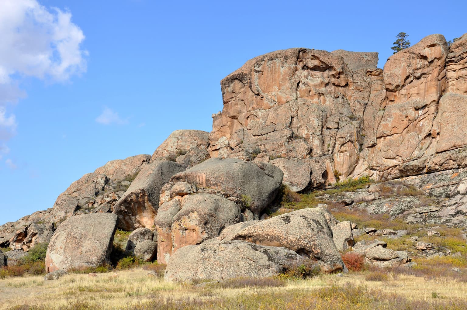
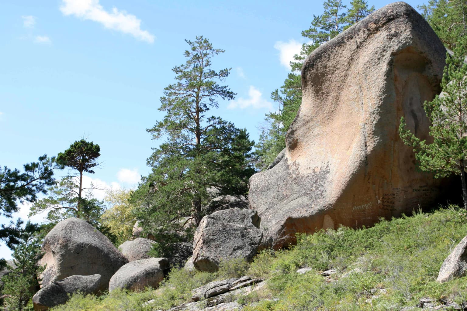
Karkaraly National Park is best known for its unique mountain-forest landscape rising abruptly from the Kazakh Steppe, creating a distinct ecological island in central Kazakhstan. The park protects one of the highest concentrations of argali (wild mountain sheep) in the region, particularly in the Kent Mountains and neighboring Beldeutas Reserve. The area contains over 30 archaeological sites spanning the Paleolithic, Bronze Age, and Iron Age, including the significant Bronze Age settlement of Kent, a 30-hectare city of metallurgists, and the ruins of Kyzyl Kensh Palace, a 17th-century Dzungar Buddhist monastery. The dramatic granite rock formations at locations like Aulietas and the legendary Zhirensakal Peak (Komsomol Peak) with its three distinctive stone towers are hallmark features of the park's landscape.

Rocky outcrop with pine trees overlooking a lake surrounded by dense forests and rolling hills under a clear blue sky
Scenic panoramic view of Karkaraly National Park featuring a lake surrounded by forested hills under a clear sky

Karkaraly National Park history and protected-area timeline

The protected status of the Karkaraly area dates to 1884 when it was first designated as the Karkaralinsk Forest Reserve, making it one of the oldest protected areas in Kazakhstan. Between 1889 and 1913, construction of numerous park cordons was completed, including Bedaik, Koktube, Ayushat, Tulkebai, and Tonkurus. In 1913, a wooden cabin was constructed to serve as the residence of the forest warden—a building that has since become one of the most well-known structures in the area.

Prior to the Bolshevik Revolution, the forest cottages in the area were allotted to army troops, Karkaraly Cossacks, and local people, with the Kent and Karkaralinsk forest cottages remaining part of the Karkaralinsk forest treasury and state property. After the October Revolution of 1917, the entire forest area became part of the state forest fund. Following several administrative reorganizations, the Karkaraly Forestry Department was officially organized in 1947.

Work on creating a national park began in the early 1990s, and on December 1, 1998, the Kazakhstani national government formally established Karkaraly National Park through official decree. The primary goal of the national park is the protection and restoration of natural ecosystems within the park boundaries. Today, the park is administered by Kazakhstan's Committee for Forestry and Hunting, with approximately 120 employees, including 104 state forest inspectors. The administration is organized into four departments: Administrative Department, Department of Protection and Wildlife Management, Department of Science, Ecological Education and Tourism, and Department of Finance.

Karkaraly National Park landscape and geographic character

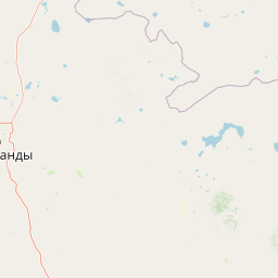
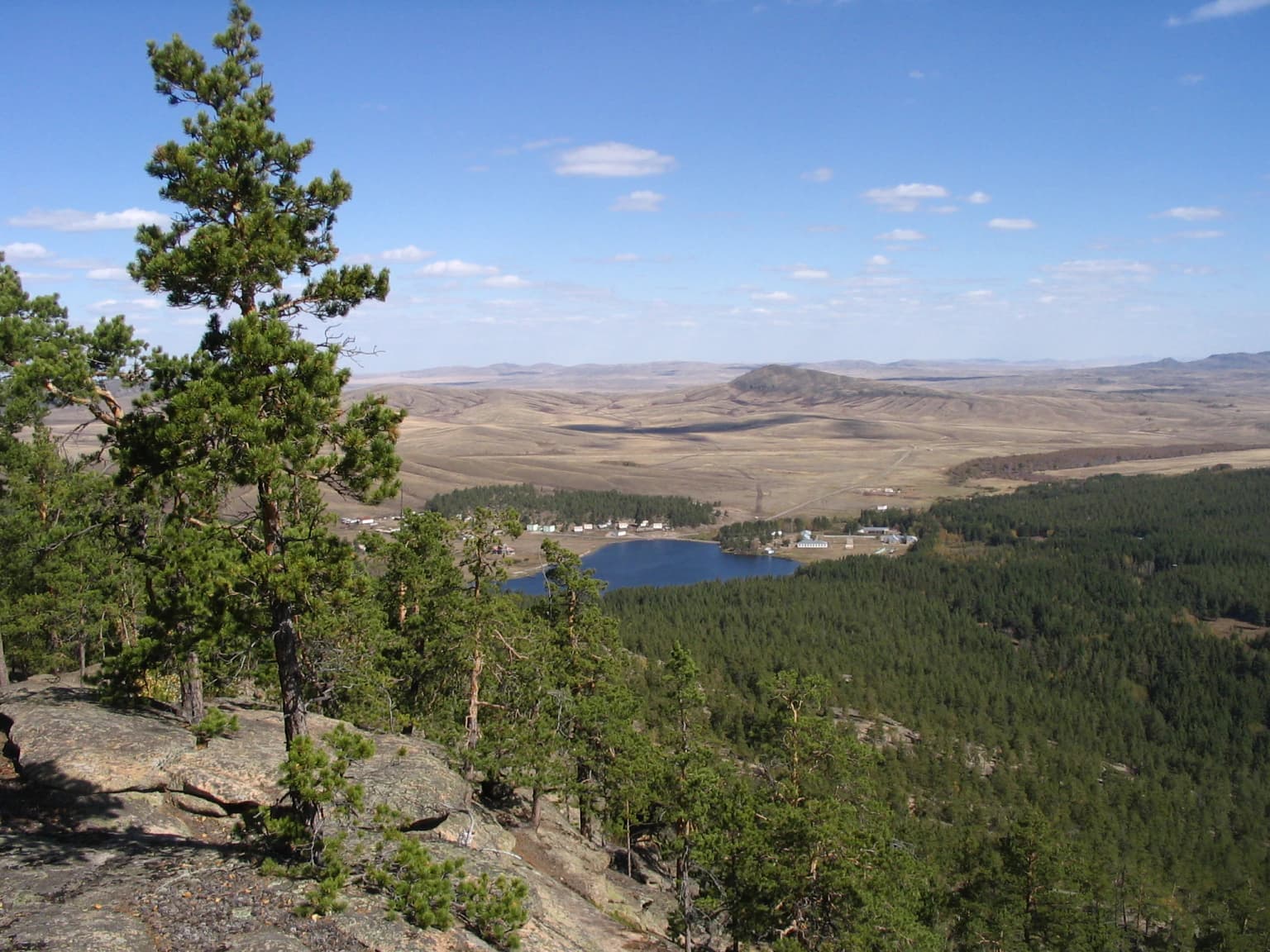
Karkaraly National Park protects a distinctive mountain landscape that rises sharply from the surrounding Kazakh Steppe, creating a dramatic island of forested peaks in the heart of central Kazakhstan's flat terrain. The park encompasses two main mountain ranges—the Karkaraly Range and the Kent Range—which feature granite formations dating back to the Paleozoic era. These ancient mountains were formed when an inland sea retreated 1.2 to 2 million years ago, leaving behind granite intrusions that were subsequently uplifted and eroded into the dramatic terrain visible today.

The terrain is characterized by steep rocky slopes, deep canyons, and distinctive rock formations sculpted by centuries of wind and precipitation. The highest point is Zhirensakal Peak at 1,403 meters above sea level, crowned with three massive granite towers that are a signature feature of the landscape. During the Cossack era, this rocky massif was called "Shish Kabani" meaning "the habitat of wild boars," and it remains surrounded by local legends.

The park contains several notable lakes. Lake Shaitankol (literally "Devil's Lake") sits at 1,200 meters elevation and is surrounded by rock cliffs reaching 10 meters high. Lake Baceen, also at 1,200 meters, is accessible via the "Stone's Tale" eco-trail. Big Lake, the most frequently visited body of water in the area, covers 2.5 square kilometers with a maximum depth of 4.6 meters and supports fishing and swimming activities. Springs and small streams originate from mountain ravines throughout the park, while unique granite rock formations are particularly prominent at Aulietas in the Kent Mountains, a site considered sacred by local residents.

Large rock formations and boulders on a grassy plain with a clear blue sky
Rock formations in the Kent Mountains of Karkaraly National Park under a clear blue sky

Karkaraly National Park ecosystems, habitats, and plant life

The park protects a diverse array of habitats that support remarkable biodiversity in the context of central Kazakhstan. Approximately 40,341 hectares of the park are forested, with pine trees dominating at 71.3% of the wooded area, followed by birch at 10% and aspen at 2%. The understory includes Cossack's juniper, Tatar's honeysuckle, and other shrubs that together cover 34% of the park's total area.

The park is estimated to contain about 800 species of flora, representing approximately 80% of all plant species found in central Kazakhstan. Of these, 244 species are listed in Kazakhstan's Red Book of Protected Species, including the Kyrgyz birch, smooth sphagnum, thin poppy, spring pheasant's eye, and the endemic Karkaraly barberry. The park also supports 87 species of medicinal, oil-bearing, and alkaloid plants. The diverse plant communities range from steppe grasslands at lower elevations through pine and birch forests to alpine meadows at higher elevations.

The park contains three designated zones: a strict protection zone covering the Kent Mountains where the natural state of the mountain-forest landscape is preserved; a recreation zone in the Karkaraly Mountains where nature protection is combined with tourism and recreational activities; and an endemic zone protecting unique species found only within the park and exceptional natural features. Approximately 22,243 hectares are completely closed to economic activity.

Stone ruins of an ancient palace structure surrounded by grassland and mountains under a partly cloudy sky
Ruins of Kizhel Kensh palace in Karkaraly National Park

Karkaraly National Park wildlife and species highlights

Karkaraly National Park supports rich wildlife populations across its diverse habitats. The park is home to 122 species of birds, of which 11 are protected in Kazakhstan's Red Book of Protected Species. These include the golden eagle, imperial eagle, steppe eagle, booted eagle, saker falcon, Eurasian eagle-owl, Dalmatian pelican, black stork, whooper swan, swan goose, and Pallas's sandgrouse. Several of these species—the imperial eagle, saker falcon, and Dalmatian pelican—receive additional international protection under the IUCN Red List.

The park contains 45 species of mammals, including wolves, foxes, badgers, wild boar, red deer, Siberian roe deer, elk, argali, lynx, and various bat species. The argali population is particularly significant, representing one of six subspecies of argali found in Kazakhstan, with the highest numbers occurring in the Kent Mountains and neighboring Beldeutas Natural Reserve. The park also provides habitat for Pallas's cat, a rare and secretive species that remains poorly studied due to its elusive behavior and wide distribution.

The park supports six species of reptiles and two species of amphibians, including four snake species, two of which are venomous—the meadow viper and Siberian pit viper. The adjacent Beldeutas Natural Reserve, which neighbors the park, supports additional rare species including golden eagle, black stork, eagle owl, and the highest concentration of argali in the area, all listed in Kazakhstan's Red Book.

Large rock formations with green vegetation and trees under a clear blue sky
Rock formations on Kent Mountain in Karkaraly National Park

Karkaraly National Park conservation status and protection priorities

Karkaraly National Park plays a crucial role in conserving Kazakhstan's natural heritage, particularly as a refuge for mountain-forest ecosystems in the central region of the country. The park protects significant populations of species listed in both national and international conservation frameworks. The argali, one of six subspecies found in Kazakhstan, receives protection within the park's boundaries, with the highest concentrations occurring in the Kent Mountains. The Pallas's cat, though populations are declining and the species remains on the verge of extinction, finds sanctuary here.

The park's zonation system supports conservation objectives while allowing for sustainable use in designated areas. The strict protection zone in the Kent Mountains preserves the natural state of the mountain-forland landscape, while approximately 22,243 hectares remain completely closed to economic activity. The park also works in conjunction with neighboring protected areas—Bektauata National Preserve (500 hectares) and Beldeutas Natural Reserve (44,660 hectares)—to form a network of conservation areas in the region.

Conservation challenges include forest fires, with significant damage occurring in 1997-1998 when 2,525 hectares burned. The park has since implemented aggressive reforestation and fire prevention programs. The protection of 244 plant species in Kazakhstan's Red Book, including endemic species like the Karkaraly barberry, underscores the park's importance for botanical conservation in central Asia.

Karkaraly National Park cultural meaning and human context

The Karkaraly area holds exceptional archaeological and cultural significance, with over 30 documented archaeological sites within the park boundaries spanning the Paleolithic, Bronze Age, and Iron Age. The most significant is the Bronze Age city of Kent, located in the middle of the Kent Mountains. This ancient settlement covered approximately 30 hectares and was home to around 1,000 inhabitants, including skilled metallurgists who produced weapons, equipment, and ornaments from copper and bronze. Excavations have revealed an abundance of bronze products, making this one of the most important Bronze Age discoveries in Kazakhstan.

The ruins of Kyzyl Kensh Palace (also spelled Kyzyl Kensh), located in the Kent Mountains, represent a 17th-century Buddhist monastery built by the Dzungars during their rule over the Kazakh steppe. The monastery, meaning "red ore" or "red city," was inhabited by lamas under Ochirtu-Tsetsen Khan and was reportedly active for approximately 50 years. Only ruins remain today, though excavations have uncovered artifacts including a Manchurian coin, decorative elements, and items suggesting the presence of guards.

Local legends enrich the cultural landscape. Lake Shaitankol is associated with a tragic love story of Sulushash and her shepherd lover Altai. Zhirensakal Peak is linked to legends of a wizard named Babay Shashty Aziz who lived in a cave at the summit and possessed miraculous powers to fulfill visitors' desires. These narratives reflect the deep connection between the local people and this mountainous landscape.

Rolling hills with patches of forest and varied vegetation under a partly cloudy sky
Landscape view of Karkaraly National Park featuring rolling hills and forested ridges

Top sights and standout views in Karkaraly National Park

Karkaraly National Park offers exceptional variety across geological, ecological, and cultural dimensions. The park's signature feature is Zhirensakal Peak (also known as Komsomol Peak) at 1,403 meters, crowned with three distinctive granite towers and steeped in local legend. Lake Shaitankol (Devil's Lake) presents a dramatic mountain lake surrounded by 10-meter cliffs, accessible via scenic eco-trails. The Kent Mountains support the region's highest populations of argali, the wild mountain sheep that are a flagship species for conservation. Archaeological treasures include the Bronze Age city of Kent—one of the most important prehistoric settlements in central Kazakhstan—and the ruins of the Dzungar-era Kyzyl Kensh Palace Buddhist monastery. The unique granite rock formations at Aulietas in the Kent Mountains, considered sacred by local residents, add spiritual dimension to the landscape. This combination of mountain-forest ecosystems, rare wildlife, prehistoric archaeology, and living legends makes Karkaraly a distinctive destination within the Kazakh Steppe.

Large rocky formations with sparse vegetation under a clear blue sky
Rock formations at Kent Mountain within Karkaraly National Park

Best time to visit Karkaraly National Park

Summer months (June through August) offer the most comfortable conditions for visiting Karkaraly National Park, with average temperatures around 18°C and daytime highs reaching 25°C. This season brings abundant flowering of alpine plants, ripening berries including strawberries and raspberries, and plentiful edible mushrooms. The warm weather permits full access to hiking trails and outdoor activities, though summer thunderstorms are common.

Spring (mid-March through May) transforms the park as temperatures rise to around 15°C, melting snow creates streams and waterfalls in mountain canyons, and wildflowers including primroses and tulips bloom across the forest floors. May is particularly pleasant with leafing trees and increased bird activity. Autumn (mid-September through mid-November) paints the forests in vivid colors and is considered the most visually striking season, particularly in September and early October when weather remains comfortable. Winter (November through March) brings cold, snowy conditions with temperatures commonly dropping to -20°C to -30°C and sustained cold lasting approximately 135 days, making this season suitable only for cold-weather activities like cross-country skiing.

Park location guide

Geography guide, regional context, and park location map for Karkaraly National Park

Karkaraly National Park park geography, regions, and map view in Kazakhstan
Understand where Karkaraly National Park sits in Kazakhstan through a broader geographic reading of the surrounding landscape, nearby location context, and its mapped position within the national park landscape.

How Karkaraly National Park fits into Kazakhstan

Kazakhstan is a Central Asian country spanning vast steppes and plains, bordered by Russia, China, Kyrgyzstan, Uzbekistan, and Turkmenistan, with a coastline along the Caspian Sea. It gained independence from the Soviet Union in 1991 and has a population of approximately 20.5 million people. The country is officially secular but predominantly Muslim, with Kazakh and Russian as official languages.

Wider geography shaping Karkaraly National Park in Kazakhstan

Kazakhstan occupies a vast territory in Central Asia, extending into Eastern Europe. Its terrain consists largely of hilly plateaus and plains, with lowlands covering about a third of the area. The southern and eastern regions are mountainous. The country borders Russia to the north and west, China to the east, Kyrgyzstan to the southeast, Uzbekistan to the south, and Turkmenistan to the southwest. It has a coastline along the Caspian Sea.

Map view of Karkaraly National Park

Use this park location map to pinpoint Karkaraly National Park in Kazakhstan, understand its exact geographic position, and read its mapped placement within the surrounding landscape more clearly.

Pigeon | © OpenStreetMap contributors

Location context for Karkaraly National Park

Karaganda Region

Visual overview of Kazakhstan's dramatic granite peaks, distinctive mountain ranges, and unique steppe-forest habitats

Karkaraly State National Nature Park Photos: Mountain-Forest Landscapes and Protected Area Scenery
Explore the visual character of Karkaraly State National Nature Park through comprehensive photography, highlighting its distinctive mountain-forest terrain. These images offer deep insight into the park's ancient granite formations, unique steppe ecosystems, and high-altitude lakes, essential for understanding its protected landscape and biodiversity.

Rocky outcrop with pine trees overlooking a lake surrounded by dense forests and rolling hills under a clear blue sky

Calm lake reflecting rocky cliffs and forested hills under a clear sky

Large rock formations and boulders on a grassy plain with a clear blue sky

Stone ruins of an ancient palace structure surrounded by grassland and mountains under a partly cloudy sky

Large rock formations with green vegetation and trees under a clear blue sky

A wide view of rocky mountains with forested slopes and a meadow under a partly cloudy sky

Rolling hills with patches of forest and varied vegetation under a partly cloudy sky

Large rocky formations with sparse vegetation under a clear blue sky

Rock formations on a mountain slope under a partly cloudy sky

Mountain peaks and forested valleys under a blue sky with scattered clouds

Dry grassland with a dead tree in the foreground and mountains in the background under a partly cloudy sky

Calm lake reflecting trees and rock formations under clear blue sky

Snow-covered evergreen trees in a snowy landscape with overcast sky

Wide landscape view of mountains, open plain, and scattered trees under a partly cloudy sky.

Rocky cliffs and mountain ranges with scattered trees under clear blue sky

Four argali sheep standing on a rocky hillside with dry vegetation

Park atlas

Discover surrounding protected landscapes and unique mountain-forest ecosystems across Central Kazakhstan.

Explore Other National Parks and Protected Areas Near Karkaraly State National Nature Park
Continue your discovery beyond Karkaraly State National Nature Park to explore other national parks and protected areas across Central Kazakhstan's diverse landscapes. Compare their unique mountain-forest ecosystems, geological formations, and archaeological sites, mapping the broader regional context and conservation efforts.
National parkKazakhstan

Bayanaul National Park: Kazakhstan's First National Park Mapped Landscape

Explore granite mountains, unique lakes, and striking rock formations.

Bayanaul National Park, situated in Kazakhstan's Pavlodar Province, represents a significant protected area renowned for its extraordinary granite mountain landscape. Established as the country's first national park, it showcases unique erosion-shaped rock formations, diverse vegetation including rare pines, and four significant freshwater lakes. This park offers a distinct visual tapestry of mountainous terrain and geological wonders within the broader Central Asian geography, making it a key destination for atlas-based discovery.

Area
684.53 km²
Established
1985
IUCN
II
Watercolor illustration of a landscape with green forests, rolling hills, and distant mountains under a soft sky
National parkAkmola Region

Buiratau State National Nature Park: Kazakhstan National Park within Akmola Region

Explore unique steppe-forest transition ecosystems and geography.

Buiratau State National Nature Park in Kazakhstan's Akmola Region protects a significant transitional zone between dry steppe and semi-arid forest. This national park showcases a diverse landscape of low ridges, plains, and salt lakes, contributing to its rich biodiversity. Discover the mapped boundaries and the unique ecological character of this protected area within the context of the Kazakh Uplands atlas and its regional geography.

Area
890 km²
Established
2011
IUCN
II
Relief
Upland
National parkEast Kazakhstan Region

Tarbagatai National Park: Protected Landscape and Wild Fruit Tree Forests in East Kazakhstan Region

Explore the mapped boundaries and ecosystem of this national park.

Tarbagatai National Park is a protected area in East Kazakhstan recognized for its unique role in conserving wild fruit tree forests that have maintained genetic isolation. This national park provides a detailed view of a mountain-steppe ecosystem across the Tarbagatai mountain range, Karabas Mountains, and Arkaly Mountains, along with the Urzhar and Emel river valleys. Its establishment in 2018 highlights its importance for biodiversity and the study of natural forest genetics, offering significant geographic context for regional protected land exploration.

Area
1,364 km²
Established
2018
IUCN
II
Relief
Mountain
Watercolor painting of a landscape with green forests, hills, and a body of water
National parkAqmola Region

Burabay State National Nature Park: Mapped Granite Hills and Forested Terrain Atlas

Explore protected landscapes in Kazakhstan's Aqmola Region.

Burabay State National Nature Park presents a unique protected landscape within the Kokshetau Massif of Kazakhstan's Aqmola Region. This atlas-focused entry details the park's distinctive terrain, featuring ancient granite outcrops and rolling hills draped in pine and birch forests. Understand the mapped boundaries and geographic setting of this national park, renowned for its scenic lakes and significant geological formations, offering rich context for protected-area discovery.

Area
1,299.35 km²
Established
2000
IUCN
II
Relief
Mixed relief
Watercolor painting depicting a mountain range, lake, and grassy foreground under a pale sky
National parkAlmaty Region

Zhongar-Alatau National Park: Protected Mountain Landscape and Genetic Heritage Atlas

Almaty Region's critical wild apple forest and glaciated terrain.

Zhongar-Alatau National Park in Kazakhstan's Almaty Region is a significant protected landscape renowned for its role in conserving the genetic origins of cultivated apples. The park encompasses dramatic glaciated mountain ranges, deep canyons, and diverse ecosystems within the Dzungarian Alatau. Its mapped boundaries define an area vital for protecting unique wild fruit tree species, including the Sievers apple, and preserving the distinctive alpine terrain of southeastern Kazakhstan, offering rich context for geographic exploration.

Area
36 km²
Established
2010
IUCN
II
Relief
Mountain
Watercolor illustration showing rolling hills, distant mountains, and sparse vegetation
National parkAlmaty Region

Altyn-Emel National Park: A Protected Landscape of Singing Dunes and Lunar Mountains

Explore unique geological wonders and ancient Saka history.

Discover Altyn-Emel National Park, a prominent national park located in Kazakhstan's Almaty Region. This protected area showcases an extraordinary diversity of landscapes, from the echoing Singing Dunes to the otherworldly Aktau mountains, often referred to as the 'lunar mountains' due to their vivid mineral hues. As a vital conservation zone, it safeguards Central Asian steppe ecosystems and significant Iron Age archaeological sites, offering a rich tapestry of natural beauty and historical depth for atlas exploration.

Area
4,600 km²
Established
1996
IUCN
II
Relief
Mixed relief
Watercolor illustration of a landscape with green hills, a body of water, and grassy foreground under a pink-hued sky
National parkAqmola Region

Kokshetau National Park: A Protected Granite Mountain and Forest-Steppe Landscape in Kazakhstan

Explore Aqmola Region's unique protected geography and mapped terrain.

Kokshetau National Park stands as a remarkable protected landscape within Kazakhstan, defined by its ancient granite mountains and its unique position as a forest-steppe island surrounded by open plains. This national park preserves a rich tapestry of boreal forests, lake-filled depressions, and geological wonders, including some of the planet's most ancient rock formations. MoriAtlas provides a structured view of Kokshetau National Park, detailing its mapped boundaries and geographic context within the Aqmola Region, offering users a deep dive into its protected area identity and ecological significance.

Area
1,821 km²
Established
1996
IUCN
II
Relief
Upland
Watercolor painting of a river, hills, and trees with pink and yellow sky tones
National parkAlmaty Region

Ile-Alatau National Park: Protected Landscape Atlas and Almaty Region Geography

Mapped boundaries, diverse ecosystems, and mountain wilderness.

Ile-Alatau National Park is a key protected area in the Almaty Region of Kazakhstan, preserving a vast expanse of the Tian Shan mountain system. This national park showcases a dramatic vertical landscape, encompassing everything from lowland woodlands and relict spruce forests to expansive alpine meadows and glacial terrains. Its mapped boundaries define critical habitat for diverse wildlife and offer a profound insight into the complex ecological dynamics of high-altitude environments, making it an essential destination for atlas-based geographic discovery.

Area
2,000 km²
Established
1996
Relief
Mixed relief
Climate
Alpine

Common questions about visiting, size, designation, and location context for Karkaraly National Park

Karkaraly National Park FAQs for park facts, access, geography, and protected area context
Find quick answers about Karkaraly National Park, including protected-area facts, park geography, trail and visitor context, and how the park fits into its surrounding country and regional landscape.
MoriAtlas Explorer

Continue Your Protected Areas Search Across the Global Atlas

Deepen your exploration by continuing the structured search for national parks and protected areas worldwide. Utilize the comprehensive filtering capabilities to compare different conservation landscapes and refine your understanding of global park geography. Discover more about the distribution and characteristics of protected natural areas.

Global natural geography