Mori Atlas logo
National parkBuiratau State National Nature Park

Discover the unique steppe-forest transition and diverse ecosystems of this Kazakh National Park.

Buiratau State National Nature Park: Protected Landscape in Akmola Region, Kazakhstan

Buiratau State National Nature Park represents a crucial protected landscape within the Akmola Region of Kazakhstan, safeguarding a rare transitional zone between dry steppe and semi-arid forest ecosystems. Established to preserve the ecological character of the Kazakh Uplands, this national park offers a distinct geographic setting characterized by low mountain ridges, inter-mountain plains, and numerous shallow salt lakes. Explore the park's mapped boundaries and understand its significant role in regional conservation through an atlas-driven perspective.

National ParkKazakhstanCentral AsiaSteppe EcosystemTransitional ZoneYereymentau Mountains
Watercolor painting showing forested hills, scattered trees, and a small structure in the midground

Buiratau State National Nature Park

National park

Park overview

Structured park overview, official facts, and landscape profile for Buiratau State National Nature Park

Buiratau State National Nature Park park facts, protected area profile, and essential visitor context
Review the core facts for Buiratau State National Nature Park, including designation, size, terrain, visitor scale, habitats, and operating context in one park-focused overview.

About Buiratau State National Nature Park

Buiratau State National Nature Park represents one of Kazakhstan's most significant protected areas for preserving the ecological character of the Kazakh Uplands, the vast elevated region that forms the heart of the country's natural landscape. Established in 2011, the park was created specifically to protect the unique transitional zone where dry steppe gives way to semi-forested landscapes, a boundary that runs through the Yereymentau Mountains and defines the park's distinctive character. The area's significance extends beyond its ecological diversity; it serves as a living laboratory for understanding how steppe and forest ecosystems interact and persist in a semi-arid continental climate. The park's establishment was part of Kazakhstan's broader conservation strategy under the Green Development 2011-2014 program, with support from the United Nations Environment Programme and the Global Environment Facility's Steppe Ecosystem Conservation project. This institutional foundation reflects the park's importance not only as a protected area but as a model for steppe conservation in Central Asia.

Quick facts and research context for Buiratau State National Nature Park

Buiratau State National Nature Park occupies 88,968 hectares across the Yereymentau Mountains in central Kazakhstan. The park sits at approximately 51°20′N 73°20′E, about 60 kilometers east of Astana, covering territory in both Akmola Region (60,815 hectares) and Karaganda Region (28,154 hectares). Established on March 11, 2011 as the 12th national park in Kazakhstan, the park is classified under IUCN Category II and is managed by the Committee of Forestry and Fauna of the Ministry of Agriculture. The area features a cold semi-arid climate with average temperatures ranging from -16°C in January to 20°C in July, receiving approximately 280 millimeters of precipitation annually.

Park context

Deeper park guide and search-rich context for Buiratau State National Nature Park

Buiratau State National Nature Park history, landscape, wildlife, and travel context
Explore Buiratau State National Nature Park through its history, landscape character, ecosystems, wildlife, conservation priorities, cultural context, and seasonal travel timing in a structured park guide built for atlas discovery and search intent.

Why Buiratau State National Nature Park stands out

Buiratau is best known for protecting the rare transitional zone between dry steppe and semi-arid forest ecosystems on the Kazakh Uplands, a landscape type found nowhere else in Kazakhstan with such intact ecological character. The park preserves relic forests and supports significant populations of Yereymentau wild sheep, a genetically distinct mountain sheep population isolated in this region. The area's botanical significance is extraordinary, with over 450 vascular plant species recorded, representing approximately 20% of all plant species found in the Central Kazakh Uplands. The combination of steppe, forest, and wetland habitats creates remarkable biodiversity, supporting 45 mammal species and 227 bird species, many of which are of conservation concern.

Landscape of Buiratau National Park featuring rolling grassy hills, scattered pine trees, and a bright blue sky with scattered clouds
Panoramic view of Buiratau National Park with grassy hills, scattered pine trees, and a clear blue sky

Buiratau State National Nature Park history and protected-area timeline

Buiratau State National Nature Park was officially established on March 11, 2011, through Government Resolution No. 247, becoming the 12th national park in Kazakhstan's system of protected areas. The park was created through the consolidation of three previously protected territories: the original core reserve, the former Belodymov Zoological Park, and the former Yereymentau Nature Reserve. This combination created a unified protected area spanning nearly 89,000 hectares across two administrative regions. The establishment was supported by the United Nations Development Programme and the Global Environment Facility through the Steppe Ecosystem Conservation and Sustainable Management Project, reflecting international recognition of the area's conservation significance. The park falls under the management of the Committee of Forestry and Fauna of the Ministry of Agriculture of Kazakhstan, with the central office located in Molodoy village in Karaganda Region. The park employs approximately 94 staff members dedicated to conservation, research, and visitor management.

Buiratau State National Nature Park landscape and geographic character

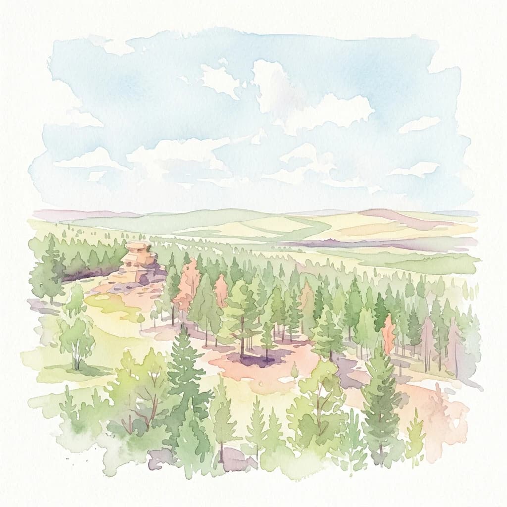
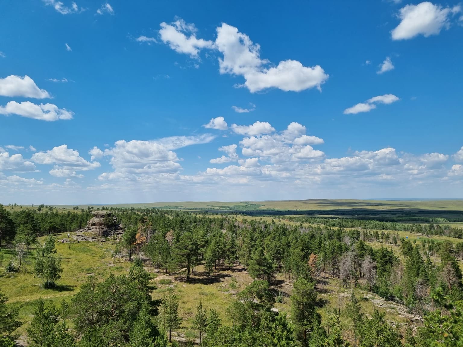
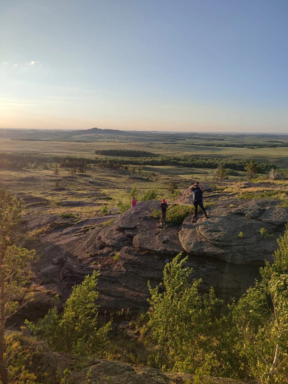
The landscape of Buiratau State National Nature Park is defined by the low ridges and hills of the Yereymentau Mountains, which rise from the central Kazakh uplands in a series of gentle but distinct elevations. Inter-mountain plains and basins separate the hill ranges, creating a varied topography that supports diverse habitats. The northern portions of the park feature dry steppe, where vegetation is sparse and the terrain opens into rolling grasslands. Moving southward, the landscape transitions into more forested areas, with tree cover increasing along the hillsides and in sheltered valleys. Stands of alder and birch follow the streams that flow through the park, providing green corridors in an otherwise semi-arid setting. A distinctive feature of the park is the many closed basins containing very shallow salt lakes, some less than one meter deep, which reflect the continental arid climate and the mineral-rich soils of the region. The largest of these are Bozaigyr and Azhybai lakes. Fresh groundwater can be found at depths ranging from 1 to 17 meters beneath the surface, supporting the vegetation in areas where surface water is limited.

Three people standing on rocky terrain overlooking open steppe landscape with scattered trees and distant hills under clear sky
Visitors at a rocky viewpoint overlooking the Kazakh steppe and forested hills during golden hour

Buiratau State National Nature Park ecosystems, habitats, and plant life

The nature of Buiratau reflects the ecological significance of preserving a transitional zone between distinct ecosystem types on the Kazakh Uplands. The park contains relic forests that represent ancient woodland remnants in an otherwise steppe-dominated landscape, providing habitat for species that require forested cover. Common plant species include scrub Siberian pea-tree (Caragana arborescens) and feather grass (Stipa), which together form the characteristic vegetation of the park's steppe and forest margins. Scientists have recorded over 450 species of vascular plants in the park, representing approximately 20% of all plant species found in the Central Kazakh Uplands. This extraordinary botanical diversity includes rare and endemic species that are of particular conservation concern, with over 30 rare species such as bloodwood, fern, lavender, spring gentian, and Gesner's tulip protected within the park's boundaries.

Buiratau State National Nature Park wildlife and species highlights

The wildlife of Buiratau State National Nature Park is notable for its diversity despite the semi-arid setting, with 45 mammal species and 227 bird species recorded within the protected area. The park is particularly significant for the Yereymentau wild sheep, a genetically distinct population of mountain sheep that is isolated from other populations in Kazakhstan's mountainous regions. This population numbers approximately 200 individuals and represents a unique conservation priority. The park's bird fauna is exceptionally diverse, comprising 46% of Kazakhstan's total bird species, with 127 species known to breed within the park. The ornithological complexes include steppe, shrubland, rocky, forest, meadow, and wetland habitats, each supporting characteristic bird communities. Of particular conservation importance, 13 breeding bird species found in the park are listed in Kazakhstan's Red Book, including species such as the steppe eagle, demoiselle crane, and various waterfowl. Additionally, 17 rare insect species are protected within the park.

Buiratau State National Nature Park conservation status and protection priorities

Buiratau State National Nature Park plays a crucial role in Kazakhstan's conservation framework as one of only a few protected areas preserving the unique transitional ecosystems between dry steppe and semi-arid forest that characterize the Kazakh Uplands. The park protects approximately one-fifth of all vascular plant species found in the Central Kazakh Uplands, making it botanically significant at a regional scale. The Yereymentau wild sheep population represents a genetically isolated population of conservation concern, requiring active management to maintain its viability. The park's bird fauna, with 227 species recorded and 46 species of conservation significance listed in Kazakhstan's Red Book, demonstrates the area's importance for avian conservation. The protection of this transitional zone is particularly important given the broader context of steppe degradation across Central Asia, as the park preserves representative examples of ecosystems that have largely disappeared outside protected boundaries.

Buiratau State National Nature Park cultural meaning and human context

Buiratau State National Nature Park is situated in a region of central Kazakhstan that has been inhabited by pastoral communities for centuries, with the Yereymentau Mountains serving as a traditional grazing area for livestock. The park's establishment consolidated several previously protected areas, including the Belodymov Zoological Park and the Yereymentau Nature Reserve, each with their own institutional history. The Kazakh-language name «Бұйратау» and Russian-language name «Буйратау» both reflect the park's identity, with the Kazakh name transliterated as "Būiratau" and the Russian as "Buyratau." The park's administrative center in Molodoy village represents the local community infrastructure that supports conservation activities in this remote region of Karaganda Region.

Top sights and standout views in Buiratau State National Nature Park

Buiratau State National Nature Park protects one of Kazakhstan's finest examples of steppe-forest transitional ecosystems on the Kazakh Uplands. The park's 88,968 hectares encompass remarkable biodiversity, with over 450 vascular plant species and 227 bird species recorded within its boundaries. The Yereymentau wild sheep population of approximately 200 individuals represents a genetically distinct and isolated population of significant conservation importance. The landscape features a distinctive combination of dry steppe, relic forests, and numerous shallow salt lakes in closed basins. Established in 2011, the park is among Kazakhstan's younger protected areas and serves as an important model for steppe ecosystem conservation in Central Asia.

Best time to visit Buiratau State National Nature Park

The best time to visit Buiratau State National Nature Park is during the summer months when the park's tourist routes are operational and the landscape displays its full ecological character. Summer brings warm conditions with average temperatures around 20°C in July, making outdoor exploration comfortable and allowing visitors to experience the full diversity of the park's steppe and forest habitats. The vegetation is at its peak during this season, with the feather grass and other steppe plants in flower, and the wildlife most active. Winter visits are possible but would experience the cold semi-arid climate with temperatures dropping to -16°C in January, which while offering a different perspective on the stark steppe landscape, would limit accessibility and visitor services. The park charges a small admission fee at the entrance and offers both individual and group tour options along four established tourist routes.

Park location guide

Geography guide, regional context, and park location map for Buiratau State National Nature Park

Buiratau State National Nature Park park geography, regions, and map view in Kazakhstan
Understand where Buiratau State National Nature Park sits in Kazakhstan through a broader geographic reading of the surrounding landscape, nearby location context, and its mapped position within the national park landscape.

How Buiratau State National Nature Park fits into Kazakhstan

Kazakhstan is a Central Asian country spanning vast steppes and plains, bordered by Russia, China, Kyrgyzstan, Uzbekistan, and Turkmenistan, with a coastline along the Caspian Sea. It gained independence from the Soviet Union in 1991 and has a population of approximately 20.5 million people. The country is officially secular but predominantly Muslim, with Kazakh and Russian as official languages.

Wider geography shaping Buiratau State National Nature Park in Kazakhstan

Kazakhstan occupies a vast territory in Central Asia, extending into Eastern Europe. Its terrain consists largely of hilly plateaus and plains, with lowlands covering about a third of the area. The southern and eastern regions are mountainous. The country borders Russia to the north and west, China to the east, Kyrgyzstan to the southeast, Uzbekistan to the south, and Turkmenistan to the southwest. It has a coastline along the Caspian Sea.

Map view of Buiratau State National Nature Park

Use this park location map to pinpoint Buiratau State National Nature Park in Kazakhstan, understand its exact geographic position, and read its mapped placement within the surrounding landscape more clearly.

Pigeon | © OpenStreetMap contributors

Location context for Buiratau State National Nature Park

Akmola RegionKaraganda Region

A visual guide to the distinctive steppe-forest transitional ecosystems and diverse terrain defining this protected area in Central Kazakhstan.

Explore Buiratau State National Nature Park Photos: Landscapes, Habitats, and Steppe-Forest Scenery
View detailed photography of Buiratau State National Nature Park to understand its unique steppe and semi-arid forest ecosystems, along with its low ridges, inter-mountain plains, and shallow salt lakes. These images provide essential visual context for appreciating the park's distinct protected-area character and its biodiversity within the Kazakh Uplands.

Landscape of Buiratau National Park featuring rolling grassy hills, scattered pine trees, and a bright blue sky with scattered clouds

A marmot stands upright in tall grass with flowering plants in the background

Three people standing on rocky terrain overlooking open steppe landscape with scattered trees and distant hills under clear sky

Park atlas

Compare diverse protected landscapes, tracing regional steppe and forest ecosystems in Akmola Region.

Discover More Protected Areas and National Parks Near Buiratau State National Nature Park
After exploring Buiratau State National Nature Park's unique steppe-forest transitional zone, browse other national parks and protected areas across Kazakhstan's Akmola Region and surrounding landscapes. This structured atlas view helps you compare diverse conservation efforts, mapped terrain, and ecological characteristics within Central Asian protected areas.
National parkKazakhstan

Bayanaul National Park: Kazakhstan's First National Park Mapped Landscape

Explore granite mountains, unique lakes, and striking rock formations.

Bayanaul National Park, situated in Kazakhstan's Pavlodar Province, represents a significant protected area renowned for its extraordinary granite mountain landscape. Established as the country's first national park, it showcases unique erosion-shaped rock formations, diverse vegetation including rare pines, and four significant freshwater lakes. This park offers a distinct visual tapestry of mountainous terrain and geological wonders within the broader Central Asian geography, making it a key destination for atlas-based discovery.

Area
684.53 km²
Established
1985
IUCN
II
Watercolor illustration of a mountainous landscape with green hills, trees, and a river in the foreground
National parkKazakhstan

Karkaraly State National Nature Park: Kazakhstan's Mountain-Forest Protected Area

Discover unique geology, archaeology, and regional landscape context.

Delve into the distinctive protected landscape of Karkaraly State National Nature Park, situated in Kazakhstan's Karaganda Region. This park preserves a rare mountain-forest ecosystem with dramatic granite formations, ancient archaeological sites, and lakes, presenting a rich geographic contrast to the surrounding Kazakh Steppe. MoriAtlas provides structured insights into Karkaraly State National Nature Park's unique terrain, its conservation value, and its position within the broader regional geography of Central Asia.

Area
1,121.2 km²
Established
1998
IUCN
II
Relief
Mountain
Watercolor painting of a landscape with green forests, hills, and a body of water
National parkAqmola Region

Burabay State National Nature Park: Mapped Granite Hills and Forested Terrain Atlas

Explore protected landscapes in Kazakhstan's Aqmola Region.

Burabay State National Nature Park presents a unique protected landscape within the Kokshetau Massif of Kazakhstan's Aqmola Region. This atlas-focused entry details the park's distinctive terrain, featuring ancient granite outcrops and rolling hills draped in pine and birch forests. Understand the mapped boundaries and geographic setting of this national park, renowned for its scenic lakes and significant geological formations, offering rich context for protected-area discovery.

Area
1,299.35 km²
Established
2000
IUCN
II
Relief
Mixed relief
Watercolor illustration of a landscape with green hills, a body of water, and grassy foreground under a pink-hued sky
National parkAqmola Region

Kokshetau National Park: A Protected Granite Mountain and Forest-Steppe Landscape in Kazakhstan

Explore Aqmola Region's unique protected geography and mapped terrain.

Kokshetau National Park stands as a remarkable protected landscape within Kazakhstan, defined by its ancient granite mountains and its unique position as a forest-steppe island surrounded by open plains. This national park preserves a rich tapestry of boreal forests, lake-filled depressions, and geological wonders, including some of the planet's most ancient rock formations. MoriAtlas provides a structured view of Kokshetau National Park, detailing its mapped boundaries and geographic context within the Aqmola Region, offering users a deep dive into its protected area identity and ecological significance.

Area
1,821 km²
Established
1996
IUCN
II
Relief
Upland
National parkEast Kazakhstan Region

Tarbagatai National Park: Protected Landscape and Wild Fruit Tree Forests in East Kazakhstan Region

Explore the mapped boundaries and ecosystem of this national park.

Tarbagatai National Park is a protected area in East Kazakhstan recognized for its unique role in conserving wild fruit tree forests that have maintained genetic isolation. This national park provides a detailed view of a mountain-steppe ecosystem across the Tarbagatai mountain range, Karabas Mountains, and Arkaly Mountains, along with the Urzhar and Emel river valleys. Its establishment in 2018 highlights its importance for biodiversity and the study of natural forest genetics, offering significant geographic context for regional protected land exploration.

Area
1,364 km²
Established
2018
IUCN
II
Relief
Mountain
Watercolor painting depicting a mountain range, lake, and grassy foreground under a pale sky
National parkAlmaty Region

Zhongar-Alatau National Park: Protected Mountain Landscape and Genetic Heritage Atlas

Almaty Region's critical wild apple forest and glaciated terrain.

Zhongar-Alatau National Park in Kazakhstan's Almaty Region is a significant protected landscape renowned for its role in conserving the genetic origins of cultivated apples. The park encompasses dramatic glaciated mountain ranges, deep canyons, and diverse ecosystems within the Dzungarian Alatau. Its mapped boundaries define an area vital for protecting unique wild fruit tree species, including the Sievers apple, and preserving the distinctive alpine terrain of southeastern Kazakhstan, offering rich context for geographic exploration.

Area
36 km²
Established
2010
IUCN
II
Relief
Mountain
Watercolor illustration showing rolling hills, distant mountains, and sparse vegetation
National parkAlmaty Region

Altyn-Emel National Park: A Protected Landscape of Singing Dunes and Lunar Mountains

Explore unique geological wonders and ancient Saka history.

Discover Altyn-Emel National Park, a prominent national park located in Kazakhstan's Almaty Region. This protected area showcases an extraordinary diversity of landscapes, from the echoing Singing Dunes to the otherworldly Aktau mountains, often referred to as the 'lunar mountains' due to their vivid mineral hues. As a vital conservation zone, it safeguards Central Asian steppe ecosystems and significant Iron Age archaeological sites, offering a rich tapestry of natural beauty and historical depth for atlas exploration.

Area
4,600 km²
Established
1996
IUCN
II
Relief
Mixed relief
National parkSverdlovsk Oblast

Pripyshminskiye Bory National Park: Explore its Protected Landscape and Geographic Setting

National Park with mapped boundaries in Sverdlovsk Oblast.

Pripyshminskiye Bory National Park stands as a notable protected area within the vast geography of Sverdlovsk Oblast, Russia. This page serves as a dedicated atlas entry for the park, detailing its protected landscape identity and its placement within the broader regional context. Users can investigate the park's mapped boundaries and understand its significance as a distinct national park, facilitating structured geographic discovery.

Area
490 km²
Established
1993
IUCN
II
Relief
Lowland

Common questions about visiting, size, designation, and location context for Buiratau State National Nature Park

Buiratau State National Nature Park FAQs for park facts, access, geography, and protected area context
Find quick answers about Buiratau State National Nature Park, including protected-area facts, park geography, trail and visitor context, and how the park fits into its surrounding country and regional landscape.
MoriAtlas Explorer

Continue Your Protected Areas Search Across the Global Atlas

Deepen your exploration by continuing the structured search for national parks and protected areas worldwide. Utilize the comprehensive filtering capabilities to compare different conservation landscapes and refine your understanding of global park geography. Discover more about the distribution and characteristics of protected natural areas.

Global natural geography