Mori Atlas logo
Wildlife reserveRéserve nationale de faune des îles de Contrecœur

Mapping the aquatic habitats and island corridors of this protected Quebec wildlife reserve

Réserve nationale de faune des îles de Contrecœur: A St. Lawrence River Protected Landscape

The Réserve nationale de faune des îles de Contrecœur protects a critical mosaic of islands, shallow channels, and freshwater wetland vegetation along the St. Lawrence River in southern Quebec. This wildlife reserve serves as a vital staging and nesting ground for waterfowl, characterized by submerged aquatic plant communities and low-lying fluvial terrain. Through this atlas entry, visualize the protected boundaries and regional geography that define this essential node in the Canadian corridor of migratory bird habitats.

national wildlife areaSt. Lawrence Riverisland habitatfreshwater wetlandaquatic vegetationwaterfowl

Réserve nationale de faune des îles de Contrecœur

Wildlife reserve

Park overview

Structured park overview, official facts, and landscape profile for Contrecœur Islands National Wildlife Area

Contrecœur Islands National Wildlife Area park facts, protected area profile, and essential visitor context

Review the core facts for Contrecœur Islands National Wildlife Area, including designation, size, terrain, visitor scale, habitats, and operating context in one park-focused overview.

About Contrecœur Islands National Wildlife Area

The Contrecœur Islands National Wildlife Area occupies a small but ecologically meaningful portion of the St. Lawrence River south of Montreal. Its territory consists of islands and adjacent waters in the Contrecœur region, falling within the regional county municipalities of Marguerite-D'Youville and D'Autray. The town of Contrecœur is the nearest urban reference point.

The reserve's primary purpose is to protect wetland habitats rather than terrestrial forests or upland scenery. Its vegetation mosaic includes emergent plants that rise above the water surface and submerged aquatic plants that grow beneath it, together creating productive conditions for fish, invertebrates, and birds. These plant communities support the reproduction and seasonal use of the area by waterfowl, an ecological role that justified the reserve's creation in 1981.

As a national wildlife area administered by the Canadian Wildlife Service, the reserve sits within a broader national framework of habitat protection. Recognition as an Important Bird Area further underscores its relevance for bird conservation across the St. Lawrence flyway. Although the area is relatively small compared to many national parks, its combination of protected status, ecological specificity, and location in one of North America's great rivers gives it an identity that is narrow but well-defined.

For visitors and researchers, the area represents a representative example of island-based riverine wildlife habitat in southern Quebec, where the interplay of water levels, plant communities, and migratory bird life defines the experience and the conservation value of the landscape.

Quick facts and research context for Contrecœur Islands National Wildlife Area

The Contrecœur Islands National Wildlife Area is a 312-hectare national wildlife area in Quebec, Canada, administered by the Canadian Wildlife Service. Established in 1981, it is one of eight national wildlife areas in Quebec and is part of the Canadian network of Important Bird Areas. Its defining features are emergent and submerged aquatic vegetation, river islands along the St. Lawrence, and waterfowl nesting habitat.

Protection and recognition

Documented terrestrial protection scope, management records, and formal designation data

Protection Status and International Recognition for Réserve nationale de faune des îles de Contrecœur

Terrestrial protection status, management scope, and official designation records for Réserve nationale de faune des îles de Contrecœur provide clear baseline conservation facts. Structured administrative data and verified protected area identifiers clarify the official conservation framework governing the landscape.

Protection details

Protection scope
Terrestrial
Transboundary protection
No
WDPA ID
555637789
Park context

Deeper park guide and search-rich context for Contrecœur Islands National Wildlife Area

Contrecœur Islands National Wildlife Area history, landscape, wildlife, and travel context

Explore Contrecœur Islands National Wildlife Area through its history, landscape character, ecosystems, wildlife, conservation priorities, cultural context, and seasonal travel timing in a structured park guide built for atlas discovery and search intent.

Why Contrecœur Islands National Wildlife Area stands out

The reserve is best known for protecting waterfowl nesting sites and freshwater wetland vegetation in the St. Lawrence River. Its combination of emergent and submerged aquatic plant communities and its status as an Important Bird Area make it a key node in the migratory bird habitat chain of southern Quebec. Its identity is shaped by the Contrecœur archipelago, a group of low-lying islands that provide sheltered conditions for nesting, feeding, and staging during seasonal migrations. The reserve's quiet, water-dominated character distinguishes it from the more terrestrial or mountainous national parks further north and west.

Contrecœur Islands National Wildlife Area history and protected-area timeline

The Contrecœur Islands National Wildlife Area was created in 1981 under Canada's national wildlife area program, administered by the Canadian Wildlife Service. Its establishment reflected growing awareness in the late twentieth century of the ecological importance of the St. Lawrence River's islands, shallow bays, and aquatic plant zones for breeding and migratory waterfowl.

The reserve was specifically designated to safeguard emergent and submerged aquatic vegetation and to protect nesting sites used by waterfowl along this stretch of the river. Over time, it gained additional recognition by being incorporated into the Important Bird Area network, aligning it more formally with national and international frameworks for bird and habitat conservation.

Its continuous management under federal authority has helped maintain its protected character through subsequent decades, even as surrounding portions of the St. Lawrence have faced pressures from development, navigation, and water-level changes.

Contrecœur Islands National Wildlife Area landscape and geographic character

The landscape of the Contrecœur Islands National Wildlife Area is defined by the St. Lawrence River rather than by terrestrial topography. The reserve consists of low-lying islands, shallow bays, and submerged or partially exposed aquatic plant beds in the river corridor south of Montreal.

Unlike parks defined by mountains, cliffs, or forests, this area's visual identity is shaped by water: broad stretches of the St. Lawrence, narrow channels between islands, and quiet vegetated shallows. The islands themselves are typically flat and low, covered with wetland-adapted plant communities rather than tall trees.

This fluvial landscape sits within the regional county municipalities of Marguerite-D'Youville and D'Autray and forms part of the broader mosaic of islands that characterize the middle St. Lawrence. The terrain is best understood as a working freshwater ecosystem, in which subtle changes in water level, ice cover, and plant growth shape both the scenery and the habitat value of the area.

Contrecœur Islands National Wildlife Area ecosystems, habitats, and plant life

The reserve's ecological character is built around freshwater wetland ecosystems. Emergent vegetation rises above the water surface, while submerged aquatic plants grow below it, creating a layered habitat structure that supports insects, fish, amphibians, and birds. These plant communities are the ecological backbone of the protected area.

Seasonal flooding, ice scour, and natural river dynamics play an important role in shaping the habitat pattern of the islands. Such processes keep the vegetation in a relatively early successional stage and maintain the open conditions preferred by many nesting waterfowl species.

Because the reserve sits within a major river system, it contributes to a broader ecological network that links upstream and downstream wetlands along the St. Lawrence. Its protected status helps preserve habitat continuity in a landscape that has otherwise seen significant human modification.

Contrecœur Islands National Wildlife Area wildlife and species highlights

The Contrecœur Islands National wildlife Area is primarily significant for its bird life, especially waterfowl. The reserve's protected emergent and submerged vegetation provides nesting cover, feeding areas, and seasonal habitat for ducks, geese, and other waterbirds that depend on the St. Lawrence River during breeding and migration periods.

The reserve's designation as an Important Bird Area reflects the consistent presence of bird populations of conservation interest. Beyond waterfowl, the mosaic of aquatic vegetation and shallow water can also support shorebirds, wading birds, and a range of fish and invertebrate species that anchor the food web.

For most visitors, the wildlife experience is quiet and observational rather than dramatic: the emphasis is on bird presence, calls over the water, and the rhythms of seasonal use rather than on large mammals or charismatic megafauna.

Contrecœur Islands National Wildlife Area conservation status and protection priorities

Conservation is the central purpose of the Contrecœur Islands National Wildlife Area. Its protected status ensures that a key stretch of St. Lawrence River island habitat is shielded from the kinds of pressures affecting surrounding lands, including shoreline development, recreational use, and changes in water management.

The reserve plays a specific role in waterfowl conservation by maintaining nesting habitat and healthy aquatic vegetation. Its inclusion in the Important Bird Area network extends that role into wider migratory bird conservation efforts, connecting local habitat protection to flyway-scale strategies.

By preserving emergent and submerged plant communities in a relatively developed landscape, the reserve also contributes to broader biodiversity conservation. These wetlands support breeding birds, fish, and invertebrates and help maintain ecological functions such as nutrient cycling and shoreline stability in the St. Lawrence River system.

Contrecœur Islands National Wildlife Area cultural meaning and human context

The Contrecœur Islands sit in a region with deep historical ties to the St. Lawrence River, where communities such as Contrecœur have long been connected to river travel, fishing, and the seasonal rhythms of the water. The reserve area continues to reflect the broader cultural identity of the Montérégie and Lanaudère regions, in which the river is a defining feature of daily life and local heritage.

The reserve itself is primarily a natural protection area rather than a cultural site, but its location within historically significant river landscapes of southern Quebec gives it a secondary cultural context as part of a long-lived riverine way of life.

Top sights and standout views in Contrecœur Islands National Wildlife Area

The reserve's highlights cluster around its role as a protected wetland within the St. Lawrence River: waterfowl nesting habitat, emergent and submerged aquatic vegetation, Important Bird Area status, and its position among Quebec's national wildlife areas. Its compact size and clearly defined ecological purpose make it a clean example of habitat-focused conservation in southern Quebec.

Best time to visit Contrecœur Islands National Wildlife Area

Visiting the Contrecœur Islands National Wildlife Area is most rewarding during the breeding and migration seasons, when waterfowl activity along the St. Lawrence is most visible. Late spring and early summer tend to highlight nesting behavior and lush aquatic vegetation, while fall migration can bring staging concentrations of waterfowl using the islands as resting and feeding habitat.

Because the area is water-dominated, conditions vary with river levels, ice cover, and weather. Calm, mild days generally offer the best chances to observe bird life across the islands and shallow bays. Winter brings ice cover that transforms the landscape but also limits access and visibility for most visitors.
Monthly climate preview

Long term monthly temperature and precipitation patterns from representative coordinates

Climate Normals and Annual Temperature Rhythm for Réserve nationale de faune des îles de Contrecœur

Historical averages for Réserve nationale de faune des îles de Contrecœur reveal wide temperature swings alongside steady precipitation distributed across the year. Reviewing the complete monthly records provides a structured baseline for understanding long term environmental conditions at this protected location.
Annual mean5 °C
-13 °C21 °C
Jan-13°
Feb-11°
Mar-4°
Apr
May13°
Jun18°
Jul21°
Aug20°
Sep15°
Oct
Nov
Dec-8°
Warmest month
July

20.6 °C

Coolest month
January

-12.9 °C

Wettest month
June

3.3 mm/day

Driest month
February

2.1 mm/day

Park location guide

Geography guide, regional context, and park location map for Contrecœur Islands National Wildlife Area

Contrecœur Islands National Wildlife Area park geography, regions, and map view in Canada

Understand where Contrecœur Islands National Wildlife Area sits in Canada through a broader geographic reading of the surrounding landscape, nearby location context, and its mapped position within the national park landscape.

How Contrecœur Islands National Wildlife Area fits into Canada

Canada is a federal parliamentary constitutional monarchy spanning North America from the Atlantic to the Pacific and Arctic Oceans. With a population of over 41 million, it is officially bilingual in English and French at the federal level. The country gained independence from the United Kingdom through a gradual process culminating in 1982.

Wider geography shaping Contrecœur Islands National Wildlife Area in Canada

Canada occupies the northern portion of North America, sharing its longest international border with the United States. The country extends from the Atlantic Ocean to the Pacific Ocean and northward into the Arctic Ocean, giving it the longest coastline of any nation.

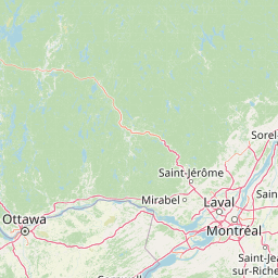
Map view of Contrecœur Islands National Wildlife Area

Use this park location map to pinpoint Contrecœur Islands National Wildlife Area in Canada, understand its exact geographic position, and read its mapped placement within the surrounding landscape more clearly.

Pigeon | © OpenStreetMap contributors

Location context for Contrecœur Islands National Wildlife Area

Quebec
Park atlas

Compare adjacent protected landscapes and river valley ecosystems across southern Quebec

Parks near Réserve nationale de faune des îles de Contrecœur and surrounding regional wildlife reserves

Browsing parks near Réserve nationale de faune des îles de Contrecœur reveals connected wetland habitats and river corridor reserves across the St. Lawrence region. Expanding the geographic comparison highlights broader protected landscapes and regional conservation areas for deeper ecological study.
A soft, painterly watercolor illustration showing a shallow waterway, green grassy islands, and soft rolling hills in the distance.
Nature reserveQuebec
About 69 km away#1 closest

Southwest

Îles de la Paix Migratory Bird Sanctuary: Protected Island Geography and Wetland Maps

A vital riverine habitat within the St. Lawrence River basin

Examine the unique river-island topography of the Îles de la Paix Migratory Bird Sanctuary in Quebec. This protected area offers a rare glimpse into a dynamic landscape of marshes and flooded forests, serving as a critical node in the St. Lawrence River migratory flyway near the Montreal metropolitan region.

Area
10.92 km²
Established
1972
IUCN
III
Relief
Lowland
A soft, watercolor painting of a calm river winding through a green landscape with trees and rolling hills in the background.
Wildlife reserveQuebec
About 75 km away#2 closest

Southwest

Réserve nationale de faune des îles de la Paix: Geography of an Island Wetland Refuge

A protected wildlife corridor in southwestern Quebec

The Réserve nationale de faune des îles de la Paix comprises a cluster of islands and protected wetlands in the St. Lawrence River. This site provides critical nesting and staging grounds within a managed habitat system, connecting forested terrestrial areas with expansive aquatic zones essential for migratory bird species.

Area
1.87 km²
Established
1977
IUCN
Ia
Relief
Lowland
National parkQuebec
About 89 km away#3 closest

North

La Mauricie National Park: Quebec National Park Atlas and Protected Landscape

Explore its mapped boundaries and natural terrain.

Delve into the protected landscape of La Mauricie National Park, a key national park situated within Quebec's diverse geography. This destination provides detailed insights into the park's mapped boundaries and its unique natural terrain, offering a structured approach to understanding protected areas and regional landscapes. It serves as an essential point for exploring the park's geographic identity and its place within the Canadian conservation atlas.

Area
536 km²
Established
1970
IUCN
II
Visitors
278.9K annual
A soft watercolor painting depicting a wide, marshy wetland scene with gentle green hills in the distance and reflections on the water surface.
Wildlife reserveQuebec
About 135 km away#4 closest

Southwest

Réserve nationale de faune du lac-Saint-François: A Protected Wetland Landscape in Quebec

Explore wildlife reserve boundaries, riparian habitats, and St. Lawrence River geography.

This protected area safeguards a diverse freshwater wetland complex along the St. Lawrence River. Covering marshes, cedar stands, and mixed hardwood forests, the reserve provides a critical sanctuary for migratory species. The geography of the site offers a unique look at transition zones between open water and inland plains, serving as a key node for bird conservation in Quebec.

Area
15.21 km²
Established
1978
IUCN
III
Relief
Lowland
Watercolor painting of a lush green landscape featuring rolling hills in the distance, a meandering stream in the midground, and wetlands with cattails in the foreground.
Protected landscapeVermont
About 191 km away#5 closest

South

Green Mountain National Forest: Mapped Geography and Protected Landscape Analysis

Examining the wilderness backbone of Vermont's mountainous terrain

Gain insight into the expansive boundaries of Green Mountain National Forest, an essential protected area spanning the Green Mountains of Vermont. This profile details the forest's composition, ranging from high-elevation spruce-fir zones to mixed hardwood slopes and extensive federal wilderness corridors, providing a foundational geographic understanding of this vital northeastern landscape.

Area
1,615.31 km²
Established
1932
Relief
Mountain
Climate
Temperate
Protected landscapeNew Hampshire
About 197 km away#6 closest

Southeast

White Mountain National Forest: Protected Landscape Atlas and Geographic Boundary Context

Mapping the alpine ridges and river valleys of New Hampshire

Delve into the geography of White Mountain National Forest, a primary federal protected landscape in the eastern United States. This overview details the mountainous terrain, including the Presidential Range and Pemigewasset Wilderness, providing a clear window into its spatial scale, watershed boundaries, and regional prominence within the New England landscape.

Area
3,038.59 km²
Established
1918
Relief
Mountain
Climate
Temperate
Protected areaAddison County
About 220 km away#7 closest

South

Joseph Battell Wilderness: Mapping Protected Ridges in the Green Mountain National Forest

A high-elevation Appalachian landscape in Addison County, Vermont.

Spanning over twelve thousand acres, the Joseph Battell Wilderness preserves a critical core of the Green Mountains. This protected area features dramatic cliff faces like Mount Horrid and a continuous sequence of summits exceeding three thousand feet. The region provides a deep look at northern hardwood habitats and the geographic influence of the Long Trail within the broader Vermont mountain landscape.

Area
49.92 km²
Established
2006
Relief
Mountain
Climate
Temperate
Wildlife reserveOntario
About 231 km away#8 closest

Southwest

Rideau Migratory Bird Sanctuary: Protected Wildlife Reserve and Regional Waterfowl Habitat

Riparian conservation zones along the Rideau River in Ontario

The Rideau Migratory Bird Sanctuary protects a strategically important riparian corridor within Ontario. This federal wildlife reserve provides essential refuge for migratory birds along the Rideau River system, offering a specialized look at the region's diverse wetland margins and floodplain geography.

Area
7.52 km²
Established
1957

Common questions about visiting, size, designation, and location context for Contrecœur Islands National Wildlife Area

Contrecœur Islands National Wildlife Area FAQs for park facts, access, geography, and protected area context

Find quick answers about Contrecœur Islands National Wildlife Area, including protected-area facts, park geography, trail and visitor context, and how the park fits into its surrounding country and regional landscape.
MoriAtlas Explorer

Continue Your Protected Areas Search Across the Global Atlas

Deepen your exploration by continuing the structured search for national parks and protected areas worldwide. Utilize the comprehensive filtering capabilities to compare different conservation landscapes and refine your understanding of global park geography. Discover more about the distribution and characteristics of protected natural areas.

Global natural geography