
Mori Atlas logo
Wildlife reserveRéserve nationale de faune des îles de la Paix

A critical freshwater island and wetland habitat network on the St. Lawrence River

Réserve nationale de faune des îles de la Paix: Mapped Protected Landscapes in Quebec

Réserve nationale de faune des îles de la Paix represents a vital protected island complex in southwestern Quebec. Situated within the shallow waters of Lac Saint-Louis, this wildlife reserve safeguards a mosaic of forested islands, marshy shorelines, and productive wetland habitats. The area serves as a primary ecological anchor for waterfowl breeding and migratory passage along the St. Lawrence flyway, maintaining federal habitat protections across its terrestrial and aquatic zones.

freshwater islandsSt. Lawrence Riverwaterfowlmigratory birdswetland habitatmarsh
A flat-style digital illustration showing a river winding through a series of green islands, with low cliffs in the background and foreground trees framing the scene.

Réserve nationale de faune des îles de la Paix

Wildlife reserve

Park overview

Structured park overview, official facts, and landscape profile for Îles-de-la-Paix National Wildlife Area

Îles-de-la-Paix National Wildlife Area park facts, protected area profile, and essential visitor context

Review the core facts for Îles-de-la-Paix National Wildlife Area, including designation, size, terrain, visitor scale, habitats, and operating context in one park-focused overview.

About Îles-de-la-Paix National Wildlife Area

The Îles-de-la-Paix National Wildlife Area is a compact island and wetland reserve on the St. Lawrence River system, designed to conserve habitat that remains functional for waterfowl and migratory birds despite the dense urbanization of the surrounding Montreal region. The reserve encompasses a group of islands in the southern part of Lac Saint-Louis, where the river broadens into a lake-like expanse before continuing downstream toward the metropolis.

From a landscape standpoint, the protected area merges forested island interiors with fringing wetlands, shallow littoral zones, and sheltered bays. This mosaic is particularly important for dabbling and diving ducks, which use the emergent vegetation and quieter shoreline pockets for nesting and brood rearing. The surrounding waters of Lac Saint-Louis provide foraging habitat and serve as a refuge during high water or harsh weather, while the islands themselves offer relatively safe and undisturbed nesting sites away from shoreline development.

The site's conservation importance stems largely from its role within the St. Lawrence flyway. Migratory waterfowl and many other bird species use the area as a key stopover, and the nesting habitat supports reproductive success for populations that range far beyond Quebec during migration. Federal recognition through both the National Wildlife Area designation and the surrounding Migratory Bird Sanctuary underscores the layered protection the islands receive, with the Canadian Wildlife Service overseeing both the terrestrial and aquatic components.

Because the reserve lies close to Beauharnois, Léry, and the broader Montreal metropolitan community, it also serves a quiet educational and ecological reference function, illustrating how small protected islands in heavily modified landscapes can retain disproportionate value for biodiversity when their habitats remain intact. While the area is not oriented toward mass public recreation, its presence within this urban-influenced region highlights the importance of preserving functional wetland and island ecosystems on the St. Lawrence.

Quick facts and research context for Îles-de-la-Paix National Wildlife Area

The Îles-de-la-Paix National Wildlife Area is located in the Montérégie region of Quebec, within the municipalities of Léry and Beauharnois, near the greater Montreal metropolitan area. The land-based national wildlife area covers about 187 hectares, while the broader migratory bird sanctuary that surrounds and overlaps with it protects roughly 7.55 square kilometers of water and shoreline.

Created in 1977 and administered by the Canadian Wildlife Service, the reserve falls within the Roussillon and Beauharnois-Salaberry regional county municipalities. It is classified as a strict nature reserve under IUCN Category Ia and is formally recognized as part of the Lac Saint-Louis and Îles-de-la-Paix Important Bird Area, reflecting its central role in regional waterfowl and migratory bird conservation on the St. Lawrence.

Protection and recognition

Documented terrestrial protection scope, management records, and official conservation designations

Réserve nationale de faune des îles de la Paix Protection Status and International Recognition

Terrestrial protection status, management scope, and official international recognition records are documented for Réserve nationale de faune des îles de la Paix. Official baseline metrics outline the protected area framework and verified database identifiers without assuming unverified conservation outcomes.

Protection details

Protection scope
Terrestrial
Transboundary protection
No
WDPA ID
555704280
Park context

Deeper park guide and search-rich context for Îles-de-la-Paix National Wildlife Area

Îles-de-la-Paix National Wildlife Area history, landscape, wildlife, and travel context

Explore Îles-de-la-Paix National Wildlife Area through its history, landscape character, ecosystems, wildlife, conservation priorities, cultural context, and seasonal travel timing in a structured park guide built for atlas discovery and search intent.

Why Îles-de-la-Paix National Wildlife Area stands out

The area is best known for protecting a cluster of freshwater islands and associated wetlands on Lac Saint-Louis that serve as one of Quebec's most important breeding and staging areas for waterfowl. The reserve's value lies in its combination of forested island cover, shallow productive bays, and marsh habitat, which together support nesting ducks, geese, and a wide variety of migratory shorebirds and songbirds during spring and fall passages. Its position within an Important Bird Area connecting the St. Lawrence ecosystem to international flyways gives the site outsized ecological significance relative to its modest size, and the overlapping national wildlife area and migratory bird sanctuary designations reflect the federal emphasis on protecting both terrestrial nesting habitats and the surrounding aquatic staging grounds.
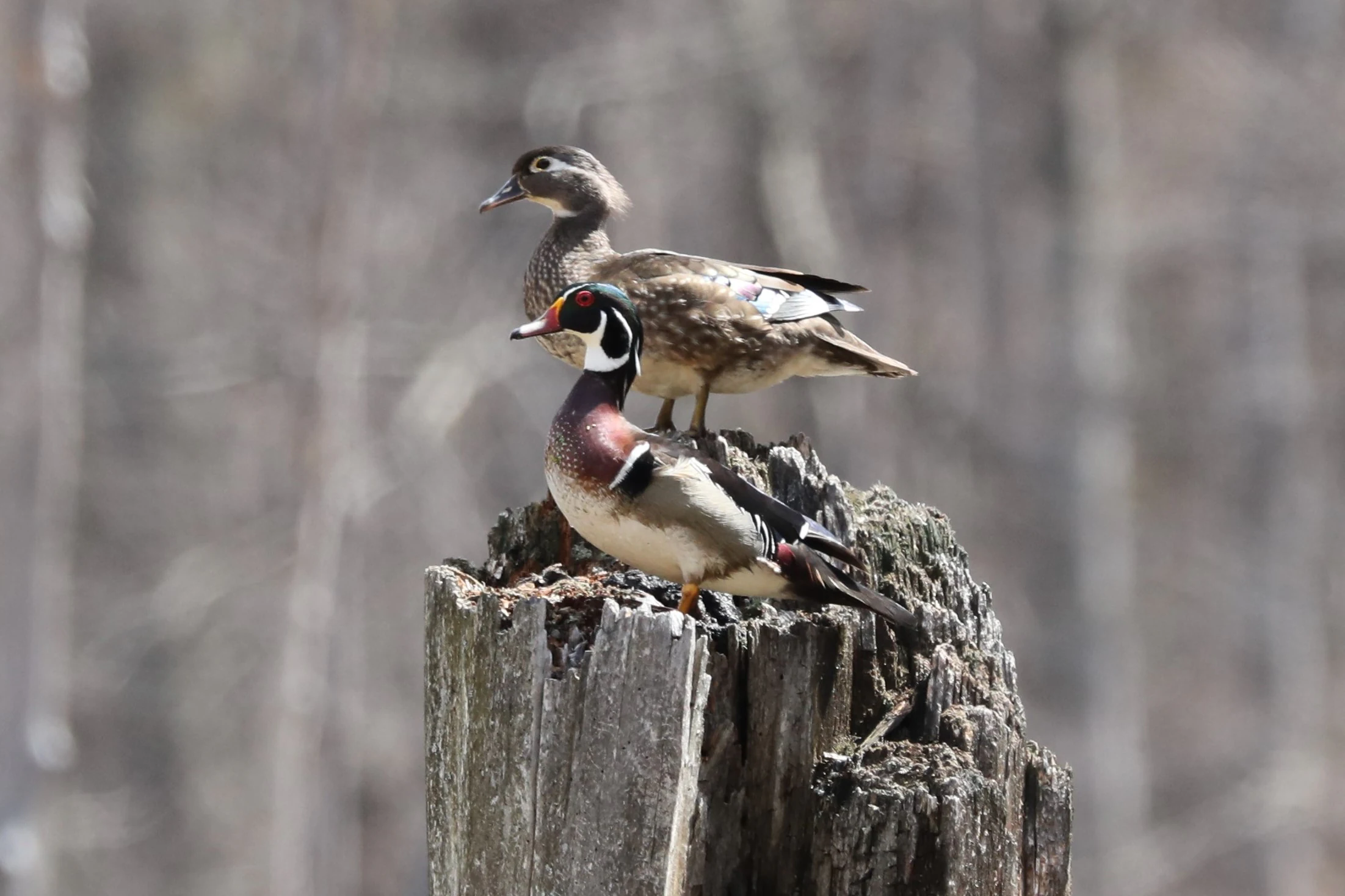
A male and female wood duck standing on top of a decaying, textured wooden stump against a blurred forest background.
A pair of wood ducks perched on a weathered tree stump in the Réserve nationale de faune des îles de la Paix.

Îles-de-la-Paix National Wildlife Area history and protected-area timeline

The federal government first placed the waters around the Îles-de-la-Paix under protective status in 1972, creating the Îles-de-la-Paix Migratory Bird Sanctuary under the authority of the Canadian Wildlife Service. This early designation recognized the islands as a significant breeding and migration area for waterfowl along the St. Lawrence.

Five years later, in 1977, the terrestrial portions of the islands were designated as the Îles-de la Paix National Wildlife Area, adding a second layer of protection explicitly aimed at conserving habitat. Since then, both the national wildlife area and the surrounding migratory bird sanctuary have been administered by the Canadian Wildlife Service, and the site has been formally recognized within the Important Bird Area network as the Lac Saint-Louis and Îles-de-la-Paix IBA, reflecting its enduring importance for bird conservation in Quebec.

Îles-de-la-Paix National Wildlife Area landscape and geographic character

The physical landscape of the Îles-de-la-Paix National Wildlife Area is defined by its position on a transition zone of the St. Lawrence River, where Lac Saint-Louis opens out into broad, shallow waters bordered by low shorelines. The protected islands occupy the southern portion of this lake-like widening, giving them a sheltered setting well away from the main flow channels used by boat traffic.

The islands themselves combine wooded interiors, often dominated by mixed deciduous species typical of the St. Lawrence lowlands, with marshy fringes and gently shelving shorelines. Surrounding bays and channels feature extensive emergent and submergent aquatic vegetation, creating productive shallow-water zones. Because of this combination of forested cover and calm, vegetated waters, the area has both a visually gentle character and a strong habitat structure for waterfowl and other bird species.
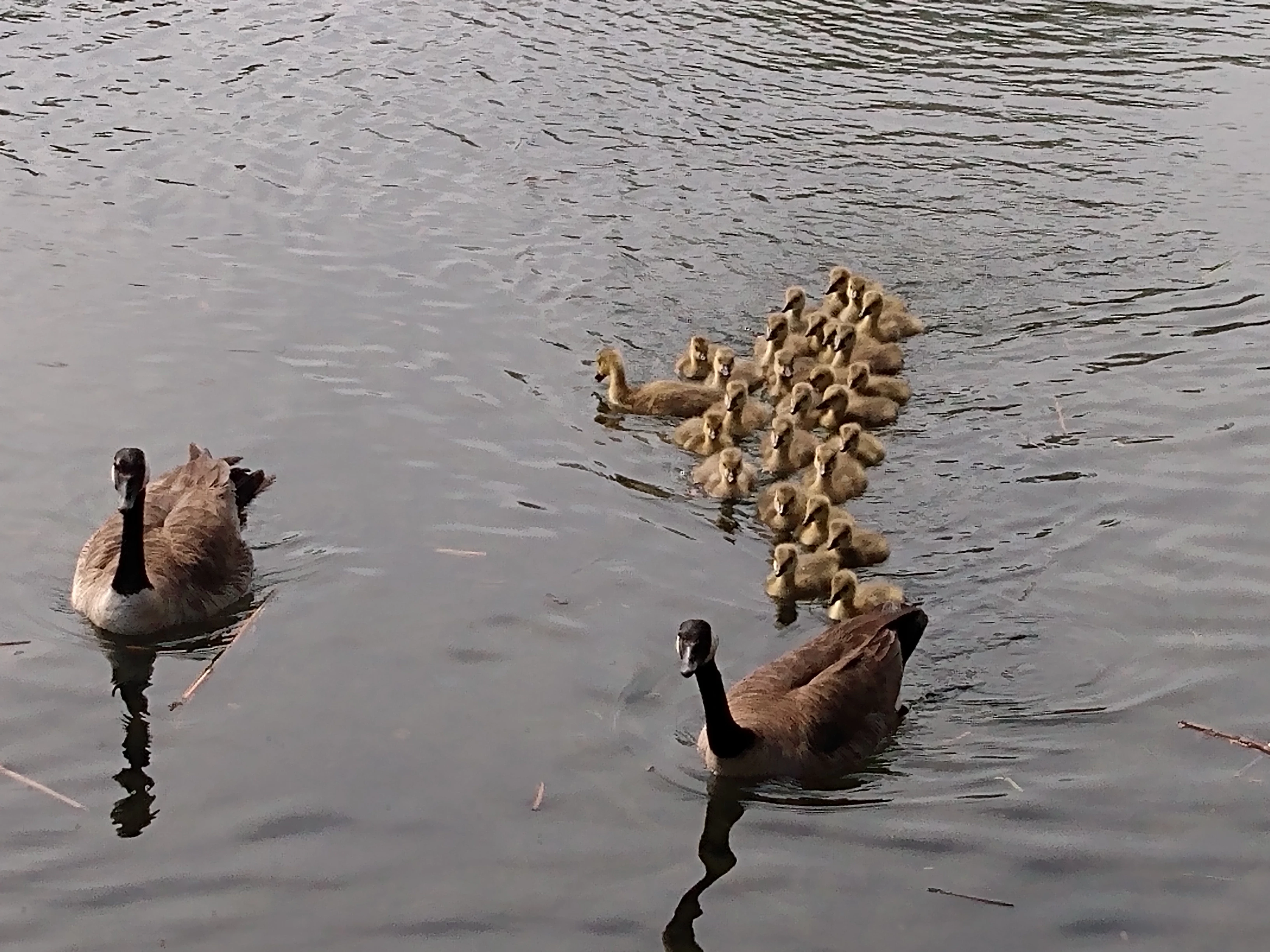
A group of Canada geese, including two adults and many goslings, swimming in a line through calm water.
A family of Canada geese swimming in the waters of the Réserve nationale de faune des îles de la Paix.

Îles-de-la-Paix National Wildlife Area ecosystems, habitats, and plant life

Ecologically, the reserve sits within the St. Lawrence lowland freshwater system, where island, wetland, and open-water habitats meet. The islands support mixed forest cover along with sheltered understory, while the fringing marshes and shallows provide the dense emergent vegetation that waterfowl depend on for nesting and feeding.

This combination of terrestrial and aquatic habitats within a small area creates an unusually rich ecological mosaic for southern Quebec. Wetland functions include nutrient retention, sediment stabilization, and support for aquatic invertebrates that anchor the food web for waterfowl and fish. The surrounding lake waters amplify this character by supplying open foraging areas and additional shoreline cover, contributing to the broader ecological integrity of Lac Saint-Louis.
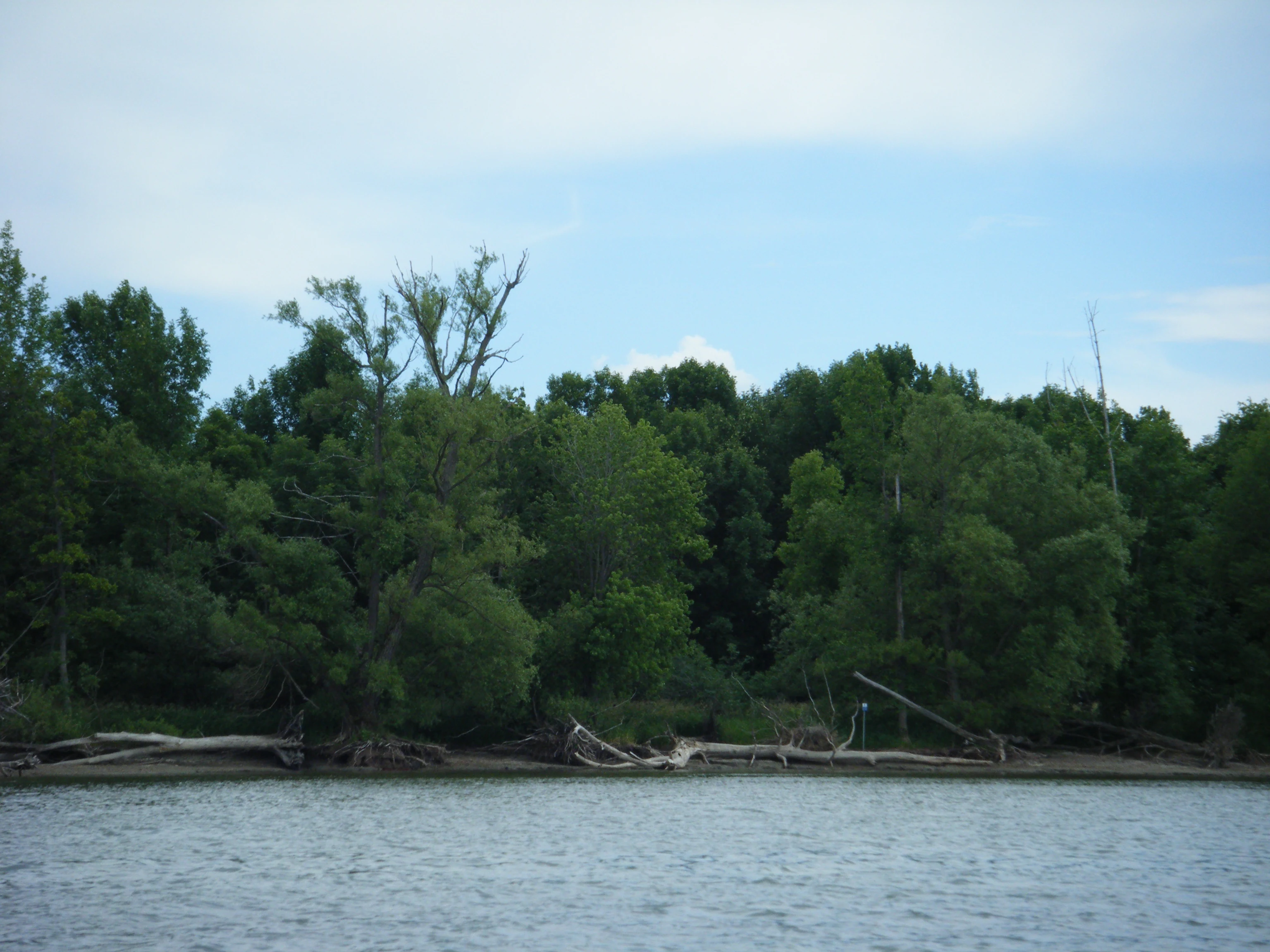
A view of a wooded riverbank with visible soil erosion and fallen logs along the water's edge.
Bank erosion along the shoreline of the Îles de la Paix National Wildlife Area.

Îles-de-la-Paix National Wildlife Area wildlife and species highlights

The wildlife profile of the reserve is dominated by birds, particularly waterfowl and migratory species. Nesting ducks use the island and marsh habitats for breeding and brood rearing, while Canada geese and other waterfowl stage in the surrounding waters during seasonal migrations. Beyond waterfowl, the islands and adjacent shallows provide habitat for a wide variety of migratory shorebirds, wading birds, and songbirds passing through the St. Lawrence flyway.

The aquatic environment also supports a range of freshwater invertebrates, amphibians, and fish typical of the St. Lawrence system, which in turn sustain the bird populations. The relatively undisturbed nature of the islands, compared with surrounding developed shorelines, makes the site a refuge for species that would otherwise face heavy pressure from human activity in this densely populated region.

Îles-de-la-Paix National Wildlife Area conservation status and protection priorities

Conservation significance at the Îles-de-la-Paix National Wildlife Area is anchored in the dual legal protection of both land and water. The national wildlife area designation protects island habitats directly, while the overlapping migratory bird sanctuary extends protection to the aquatic environment that sustains waterfowl during breeding and migration.

Recognition within the Important Bird Area network underscores the reserve's role as a Key Biodiversity Area for birds in southern Quebec. In the broader context of the St. Lawrence, where urbanization, shoreline development, and industrial activity have heavily modified aquatic habitats, the reserve functions as a small but high-value refuge, preserving functional wetland, island, and lake habitats at a key point on a major migratory corridor.

Îles-de-la-Paix National Wildlife Area cultural meaning and human context

The islands lie within the traditional territory of Indigenous peoples of the St. Lawrence valley, whose historical relationship with the river and its islands long predates European settlement. In the modern era, the reserve sits within the municipalities of Léry and Beauharnois and adjacent to the greater Montreal metropolitan community, where the St. Lawrence and its islands carry strong cultural significance as part of the regional landscape and identity. While the reserve itself is managed primarily for ecological conservation rather than cultural interpretation, its proximity to these communities links it to the broader human history of the river.

Top sights and standout views in Îles-de-la-Paix National Wildlife Area

Key distinguishing features of the Îles-de-la-Paix National Wildlife Area include its layered federal protections, with both a National Wildlife Area and a Migratory Bird Sanctuary overlapping on the same islands, and its formal recognition within the Important Bird Area network as the Lac Saint-Louis and Îles-de-la-Paix IBA. The site is notable for combining forested island nesting habitat with extensive surrounding marsh and shallow-water habitat in a compact area, making it disproportionately valuable for waterfowl breeding on the St. Lawrence.

Best time to visit Îles-de-la-Paix National Wildlife Area

The reserve's seasonal character is shaped by the rhythms of migration and waterfowl breeding on the St. Lawrence. Spring brings the arrival and nesting activity of waterfowl and many other migratory species, while fall is a major staging period, particularly for ducks and geese using Lac Saint-Louis before continuing south. Summer offers the most active nesting conditions on the islands, while winter brings quieter conditions, frozen or partially frozen waters, and reduced bird activity. As the area is primarily a conservation site rather than a heavily developed visitor destination, any visit is best framed around observing the seasonal behavior of birds and wetland conditions.
Monthly climate preview

Long-term monthly temperature and precipitation patterns from representative coordinates

Réserve nationale de faune des îles de la Paix Climate Normals and Average Temperatures

Representative coordinates record long-term monthly temperature ranges from negative winter means to summer maximums exceeding thirty degrees alongside steady year-round precipitation averages. Opening the complete monthly dataset provides comprehensive records for analyzing annual climate patterns across the protected landscape.
Annual mean6 °C
-12 °C22 °C
Jan-12°
Feb-10°
Mar-3°
Apr
May13°
Jun19°
Jul22°
Aug21°
Sep16°
Oct
Nov
Dec-7°
Warmest month
July

21.5 °C

Coolest month
January

-11.7 °C

Wettest month
June

3.4 mm/day

Driest month
February

2.2 mm/day

Park location guide

Geography guide, regional context, and park location map for Îles-de-la-Paix National Wildlife Area

Îles-de-la-Paix National Wildlife Area park geography, regions, and map view in Canada

Understand where Îles-de-la-Paix National Wildlife Area sits in Canada through a broader geographic reading of the surrounding landscape, nearby location context, and its mapped position within the national park landscape.

How Îles-de-la-Paix National Wildlife Area fits into Canada

Canada is a federal parliamentary constitutional monarchy spanning North America from the Atlantic to the Pacific and Arctic Oceans. With a population of over 41 million, it is officially bilingual in English and French at the federal level. The country gained independence from the United Kingdom through a gradual process culminating in 1982.

Wider geography shaping Îles-de-la-Paix National Wildlife Area in Canada

Canada occupies the northern portion of North America, sharing its longest international border with the United States. The country extends from the Atlantic Ocean to the Pacific Ocean and northward into the Arctic Ocean, giving it the longest coastline of any nation.

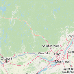
Map view of Îles-de-la-Paix National Wildlife Area

Use this park location map to pinpoint Îles-de-la-Paix National Wildlife Area in Canada, understand its exact geographic position, and read its mapped placement within the surrounding landscape more clearly.

Pigeon | © OpenStreetMap contributors

Location context for Îles-de-la-Paix National Wildlife Area

Quebec

Explore photographic records of wetland habitats, forested islands, and river scenery.

Visualizing Réserve nationale de faune des îles de la Paix Photos and Landscapes

Visual records illustrate the protected island complex, shallow bays, and marshy shorelines defining Réserve nationale de faune des îles de la Paix. Photographic documentation reveals the sheltered river environment and complex wetland habitats supporting regional waterfowl populations.

A male and female wood duck standing on top of a decaying, textured wooden stump against a blurred forest background.

Aerial view of green islands surrounded by water, with visible shoreline protection structures like curved breakwaters off the coast of the islands.

A group of Canada geese, including two adults and many goslings, swimming in a line through calm water.

A view of a wooded riverbank with visible soil erosion and fallen logs along the water's edge.

Park atlas

Compare regional wetland reserves and protected landscapes across the St Lawrence River valley

Parks Near Réserve Nationale de Faune des Îles de la Paix And Surrounding Protected Areas

Browse other protected areas and wetland habitats situated near Réserve nationale de faune des îles de la Paix to compare regional river ecosystems. Exploring adjacent conservation zones reveals broader patterns in St Lawrence watershed geography and local bird sanctuary distribution.
A soft, painterly watercolor illustration showing a shallow waterway, green grassy islands, and soft rolling hills in the distance.
Nature reserveQuebec
Mapped location lies within the park boundary#1 closest

East

Îles de la Paix Migratory Bird Sanctuary: Protected Island Geography and Wetland Maps

A vital riverine habitat within the St. Lawrence River basin

Examine the unique river-island topography of the Îles de la Paix Migratory Bird Sanctuary in Quebec. This protected area offers a rare glimpse into a dynamic landscape of marshes and flooded forests, serving as a critical node in the St. Lawrence River migratory flyway near the Montreal metropolitan region.

Area
10.92 km²
Established
1972
IUCN
III
Relief
Lowland
A soft watercolor painting depicting a wide, marshy wetland scene with gentle green hills in the distance and reflections on the water surface.
Wildlife reserveQuebec
About 61 km away#2 closest

Southwest

Réserve nationale de faune du lac-Saint-François: A Protected Wetland Landscape in Quebec

Explore wildlife reserve boundaries, riparian habitats, and St. Lawrence River geography.

This protected area safeguards a diverse freshwater wetland complex along the St. Lawrence River. Covering marshes, cedar stands, and mixed hardwood forests, the reserve provides a critical sanctuary for migratory species. The geography of the site offers a unique look at transition zones between open water and inland plains, serving as a key node for bird conservation in Quebec.

Area
15.21 km²
Established
1978
IUCN
III
Relief
Lowland
Wildlife reserveQuebec
About 75 km away#3 closest

Northeast

Réserve nationale de faune des îles de Contrecœur: Mapped Wildlife Reserve and Wetland Habitat

Protected freshwater ecosystems in the St. Lawrence River, Quebec

Discover the geographic footprint of the Réserve nationale de faune des îles de Contrecœur, a protected network of islands and channels in the St. Lawrence River. This entry provides context on the reserve's role in conserving emergent aquatic vegetation and waterfowl nesting sites within the broader southern Quebec landscape.

Area
3.12 km²
Established
1981
IUCN
Ia
Relief
Lowland
Watercolor painting of a lush green landscape featuring rolling hills in the distance, a meandering stream in the midground, and wetlands with cattails in the foreground.
Protected landscapeVermont
About 147 km away#4 closest

South

Green Mountain National Forest: Mapped Geography and Protected Landscape Analysis

Examining the wilderness backbone of Vermont's mountainous terrain

Gain insight into the expansive boundaries of Green Mountain National Forest, an essential protected area spanning the Green Mountains of Vermont. This profile details the forest's composition, ranging from high-elevation spruce-fir zones to mixed hardwood slopes and extensive federal wilderness corridors, providing a foundational geographic understanding of this vital northeastern landscape.

Area
1,615.31 km²
Established
1932
Relief
Mountain
Climate
Temperate
National parkQuebec
About 160 km away#5 closest

Northeast

La Mauricie National Park: Quebec National Park Atlas and Protected Landscape

Explore its mapped boundaries and natural terrain.

Delve into the protected landscape of La Mauricie National Park, a key national park situated within Quebec's diverse geography. This destination provides detailed insights into the park's mapped boundaries and its unique natural terrain, offering a structured approach to understanding protected areas and regional landscapes. It serves as an essential point for exploring the park's geographic identity and its place within the Canadian conservation atlas.

Area
536 km²
Established
1970
IUCN
II
Visitors
278.9K annual
Wildlife reserveOntario
About 166 km away#6 closest

West

Rideau Migratory Bird Sanctuary: Protected Wildlife Reserve and Regional Waterfowl Habitat

Riparian conservation zones along the Rideau River in Ontario

The Rideau Migratory Bird Sanctuary protects a strategically important riparian corridor within Ontario. This federal wildlife reserve provides essential refuge for migratory birds along the Rideau River system, offering a specialized look at the region's diverse wetland margins and floodplain geography.

Area
7.52 km²
Established
1957
Watercolor painting of green hills, islands, and a body of water under a pale yellow sky
National parkOntario
About 170 km away#7 closest

Southwest

Thousand Islands National Park: Exploring Ontario's Protected Landscape Geography

Discover the mapped terrain and regional context of this national park.

Uncover the protected landscape identity of Thousand Islands National Park, a key national park located in Ontario. This resource focuses on its geographic setting, mapped boundaries, and overall atlas context, providing a clear understanding of its role as a protected area. Explore how its unique terrain contributes to the regional geography and the broader national park network, offering valuable insight for landscape-focused discovery.

Area
24.4 km²
Established
1904
IUCN
II
Visitors
109.3K annual
Protected areaAddison County
About 174 km away#8 closest

Southeast

Joseph Battell Wilderness: Mapping Protected Ridges in the Green Mountain National Forest

A high-elevation Appalachian landscape in Addison County, Vermont.

Spanning over twelve thousand acres, the Joseph Battell Wilderness preserves a critical core of the Green Mountains. This protected area features dramatic cliff faces like Mount Horrid and a continuous sequence of summits exceeding three thousand feet. The region provides a deep look at northern hardwood habitats and the geographic influence of the Long Trail within the broader Vermont mountain landscape.

Area
49.92 km²
Established
2006
Relief
Mountain
Climate
Temperate

Common questions about visiting, size, designation, and location context for Îles-de-la-Paix National Wildlife Area

Îles-de-la-Paix National Wildlife Area FAQs for park facts, access, geography, and protected area context

Find quick answers about Îles-de-la-Paix National Wildlife Area, including protected-area facts, park geography, trail and visitor context, and how the park fits into its surrounding country and regional landscape.
MoriAtlas Explorer

Continue Your Protected Areas Search Across the Global Atlas

Deepen your exploration by continuing the structured search for national parks and protected areas worldwide. Utilize the comprehensive filtering capabilities to compare different conservation landscapes and refine your understanding of global park geography. Discover more about the distribution and characteristics of protected natural areas.

Global natural geography