
Mori Atlas logo
Wildlife reserveJiwani Coastal Wetland

A critical Ramsar-listed estuarine environment and marine turtle sanctuary on the Arabian Sea.

Jiwani Coastal Wetland: Exploring the Geography and Protected Landscape of Balochistan

Jiwani Coastal Wetland represents a vital protected landscape at the northeastern edge of Gwatar Bay in Balochistan. This wildlife reserve features an intricate network of brackish lagoons, mangrove swamps, and sandy nesting beaches shaped by the Dasht River delta. The site provides a critical contrast to the arid regional terrain, serving as an essential habitat for migratory bird populations and marine turtles within this southwestern coastal sector.

coastal wetlandmangrove forestRamsar sitesea turtle nestingmigratory birdsBalochistan coast
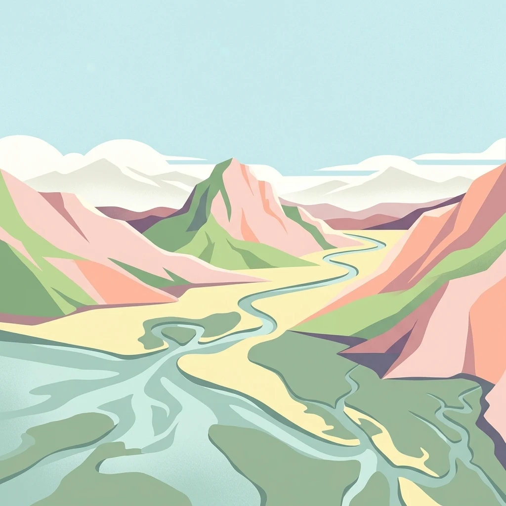
A colorful digital illustration depicting a winding river or estuary flowing through a valley surrounded by stylized mountains and low-lying coastal terrain.

Jiwani Coastal Wetland

Wildlife reserve

Park overview

Structured park overview, official facts, and landscape profile for Jiwani Coastal Wetland

Jiwani Coastal Wetland park facts, protected area profile, and essential visitor context

Review the core facts for Jiwani Coastal Wetland, including designation, size, terrain, visitor scale, habitats, and operating context in one park-focused overview.

About Jiwani Coastal Wetland

Jiwani Coastal Wetland occupies a distinctive position along Pakistan's southwestern coast, where the more typically arid landscapes of Balochistan meet the marine and estuarine systems of the Arabian Sea. Sitting at the northeastern edge of Gwatar Bay, the wetland is anchored by a lagoon closely linked to the Dasht River delta. The Dasht River and seasonal runoff from elevated terrain in the region supply the freshwater inputs that sustain the mangrove forests and shape the brackish character of the lagoon.

The site is structured around several interlinked habitats. The mangrove swamps, dominated by Avicennia marina, occupy much of the swampy and marshy area near the river delta. Adjacent to these forests are extensive sandy beaches, sand bars, and smaller islets that form the marine edge of the wetland. Together, these environments create one of the few large coastal wetland complexes along this stretch of coastline, giving the area strong regional ecological importance.

Jiwani also carries significance for some of the country's most threatened marine species. The clustered turtle beaches on the eastern side of the coastline are recognized nesting sites for endangered olive ridley sea turtles and green sea turtles, and they are frequently singled out as among the most important marine turtle sites in Pakistan. The lagoon and its beaches similarly attract migratory and resident birds, including species recorded in detailed ornithological work covering the area. Recognition as a Ramsar site in 2001 formalized the wetland's place within the international system of wetlands of importance, helping to anchor subsequent conservation initiatives focused on both the mangroves and the sea turtles.

Quick facts and research context for Jiwani Coastal Wetland

Jiwani Coastal Wetland is a coastal lagoon system in Gwadar District, Balochistan, located at the northeastern edge of Gwatar Bay near the Dasht River delta. The site is listed as a Ramsar Wetland of International Importance, having been designated in May 2001. Its ecological character is built around mangrove swamps, sandy beaches, sand bars, and islets in an otherwise arid coastal environment.

Freshwater input comes mainly from the Dasht River and seasonal rainfall runoff from nearby hills. The most widespread mangrove species at the site is Avicennia marina. Recognized wildlife values include major sea turtle nesting activity and large seasonal populations of migratory birds.

Protection and recognition

Documented marine protection scope, management records, and Ramsar site listing for Jiwani Coastal Wetland

Jiwani Coastal Wetland Protection Status and International Recognition

Jiwani Coastal Wetland features documented marine protection status and official Ramsar site listing details. Structured facts highlight international recognition sources and management scope across the protected area.

International recognition

Protection details

Protection scope
Marine
Transboundary protection
No
Park context

Deeper park guide and search-rich context for Jiwani Coastal Wetland

Jiwani Coastal Wetland history, landscape, wildlife, and travel context

Explore Jiwani Coastal Wetland through its history, landscape character, ecosystems, wildlife, conservation priorities, cultural context, and seasonal travel timing in a structured park guide built for atlas discovery and search intent.

Why Jiwani Coastal Wetland stands out

Jiwani Coastal Wetland is best known for its combination of mangrove-dominated estuarine habitat, sea turtle nesting beaches, and migratory bird concentrations along an otherwise arid Arabian Sea coastline. The site's four clustered turtle beaches on the eastern side of the coastline have been highlighted as one of the most important marine turtle nesting areas in Pakistan, supporting both olive ridley and green sea turtles. Equally central to its identity is the mangrove swamp environment, where Avicennia marina forms the dominant vegetation. The wetland's Ramsar status reinforces its standing, recognizing both the ecological value of the lagoon and the importance of the migratory and resident birdlife that depends on this coastal habitat.
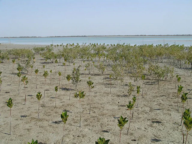
A wide view of a coastal wetland area where numerous young mangrove saplings are planted in rows across a sandy tidal flat, with the open water visible in the distance under a pale sky.
A mangrove sapling plantation in the Jiwani Coastal Wetland of Balochistan.

Jiwani Coastal Wetland history and protected-area timeline

Jiwani Coastal Wetland received international recognition on 10 May 2001 when it was designated as a Ramsar Wetland of International Importance, becoming one of the nineteen Ramsar sites in Pakistan at the time of listing.

Prior to and around its designation, the site already functioned as a working coastal landscape, with fishing acting as one of the main sources of income for local communities. The growing interest in expanding fishing rights and offshore drilling activity in the region later added pressure on the wetland and increased conservation concern. In 1999, WWF–Pakistan launched dedicated conservation efforts through its Mangrove Conservation Project and Turtle Conservation Project, focused on protecting both the mangrove forests and the important turtle nesting beaches. These initiatives, together with the broader Balochistan Conservation Strategy that emphasized sustainable development in the province, helped shape the management framework around the wetland in the years following its Ramsar listing.

Jiwani Coastal Wetland landscape and geographic character

The dominant landscape feature of Jiwani Coastal Wetland is a coastal lagoon set at the northeastern edge of Gwatar Bay, framed by the Dasht River delta to the north and the small coastal town of Jiwani to the southwest. Around the lagoon, the terrain unfolds into a layered coastal scenery: swampy and marshy ground near the delta gradually transitions into open water, sandy beaches, sand bars, and small islets further out toward the bay.

The surrounding region is otherwise arid, defined by low rainfall and a dry climate that makes the river-fed wetland landscape stand out in stark contrast. The Dasht River acts as the principal hydrological thread shaping the wetland, supplemented by seasonal runoff from nearby hills that contributes additional moisture during the wetter parts of the year. The visual character of the site is therefore strongly tied to the interplay of water, mangrove vegetation, and exposed sandy or coral-derived shoreline, making it one of the more visually distinctive coastal settings on the Balochistan coast.
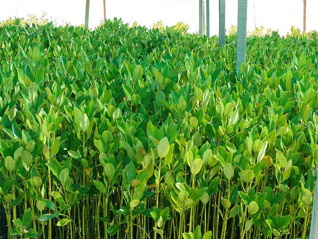
A dense cluster of young mangrove saplings growing in a nursery, with vertical support posts visible in the background.
A dense mangrove nursery, demonstrating conservation efforts at Jiwani Coastal Wetland.

Jiwani Coastal Wetland ecosystems, habitats, and plant life

Jiwani Coastal Wetland is ecologically organized around two principal habitat types: mangrove swamps and sandy beaches. The mangrove component is built largely on Avicennia marina, one of only three mangrove species recorded in Pakistan. Near the Dasht River delta, this mangrove forest occupies the swampy and marshy ground, with freshwater input from the river and seasonal rain runoff sustaining the vegetation in an otherwise dry coastal setting.

The sandy beach and marine fringe complements the mangrove environment, particularly in the area of the four clustered turtle beaches on the eastern side of the coastline. The wetland's ecological identity is also shaped by coral fragments and dead coral deposits visible on parts of the shoreline. Within the broader Balochistan coast, the combination of brackish lagoon, mangrove swamp, sandy beach, and river delta gives Jiwani a habitat diversity that is not widely repeated elsewhere in the province.
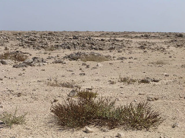
A wide, arid landscape under a clear sky, showing sparse desert-like vegetation in the foreground and patches of rocky, dead coral debris scattered across the sandy ground.
Arid coastal terrain featuring exposed dead coral remnants within the Jiwani Coastal Wetland.

Jiwani Coastal Wetland wildlife and species highlights

The wildlife of Jiwani Coastal Wetland is anchored by two broadly recognized natural themes: the marine reptiles that depend on its beaches and the birdlife that relies on its lagoons, mangroves, and shoreline mudflats. The site is widely regarded as one of the most important sea turtle nesting areas in Pakistan. Both olive ridley sea turtles, which are endangered, and green sea turtles nest on the four clustered beaches along the eastern side of the coastline, giving the site a particular conservation profile.

The lagoon and its associated mangroves also attract a notable diversity of birds. Avian surveys of the Jiwani coastal wetlands have recorded 112 bird species, of which 79 are migratory and the remaining 33 are resident. Among the migratory species, the majority arrive during the winter season, while smaller numbers pass through in summer or remain through the year. This combination of marine turtle nesting and large-scale seasonal bird movements positions Jiwani as one of the more wildlife-rich coastal sites in Pakistan's network of protected wetlands.
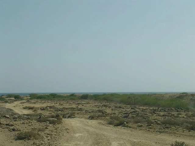
A wide shot of a dusty, unpaved path winding through a arid, rocky coastal landscape under a hazy sky, with the dark blue ocean visible in the distant horizon.
A dirt track leads towards the coast at Jiwani Coastal Wetland, featuring exposed rocky ground and sparse vegetation.

Jiwani Coastal Wetland conservation status and protection priorities

The conservation profile of Jiwani Coastal Wetland rests on three main pillars: its Ramsar recognition, its importance as a sea turtle nesting habitat, and its mangrove forest values. The wetland was inscribed as a Ramsar site in 2001, formally acknowledging its ecological significance at an international level. This designation has helped frame subsequent management responses, including targeted species and habitat conservation efforts.

In 1999, WWF–Pakistan launched a Mangrove Conservation Project and a Turtle Conservation Project, both aimed at reducing threats to the wetland. Despite these measures, the site faces ongoing pressure. Fishing is the main livelihood in the surrounding area, and proposed foreign concessions for fishing and offshore drilling have heightened conservation concern. Local communities also rely on mangrove wood for domestic needs, which adds to the pressure on the mangrove forest. The Balochistan Conservation Strategy emphasizes the sustainable use and protection of these coastal wetlands as part of broader development planning in Balochistan, providing a regional policy framework for the site's continued management.

Jiwani Coastal Wetland cultural meaning and human context

The cultural context of Jiwani Coastal Wetland is closely tied to the livelihoods of the local coastal communities, whose economy and daily routines have long been shaped by the sea. Fishing is the principal source of income, reflecting the central role of marine resources in local life. The use of mangrove wood for domestic purposes also forms part of the traditional interaction between local residents and the wetland's vegetation.

The wider region of Balochistan, and Gwadar District in particular, has historically balanced limited freshwater availability with a strong orientation toward coastal resources. Conservation strategies in the province, including the Balochistan Conservation Strategy, reflect an effort to align this traditional relationship with sustainable management of fragile coastal ecosystems like Jiwani.

Top sights and standout views in Jiwani Coastal Wetland

The standout features of Jiwani Coastal Wetland include its mangrove-dominated estuarine habitat at the northeastern edge of Gwatar Bay, its clustered sea turtle nesting beaches that are among the most important in Pakistan, and its significance as a Ramsar-listed site supporting dozens of migratory bird species. The contrast between the arid Balochistan hinterland and the water-rich, mangrove-lined lagoon gives the site a unique visual and ecological character within the country.

Best time to visit Jiwani Coastal Wetland

The character of a visit to Jiwani Coastal Wetland is shaped strongly by seasonal cycles. Winter brings the largest influx of migratory birds, including many waterbirds and shorebirds that use the lagoon and adjacent mudflats, and is generally considered the most rewarding season for birdwatching. The wet phases of the year, when seasonal runoff from nearby hills supplements the Dasht River, can also bring a fresher, more visibly lush appearance to the mangrove forest. Sea turtle nesting activity tends to be biologically tied to specific seasons, and the turtle beaches are most ecologically significant during their nesting period; visitors interested in that aspect of the site should accordingly align travel with the relevant breeding season.
Monthly climate preview

Long-term representative temperature and precipitation records for Jiwani Coastal Wetland

Jiwani Coastal Wetland Climate Normals and Annual Weather Patterns

Jiwani Coastal Wetland maintains measured long-term temperature ranges and minimal precipitation values across the recorded annual cycle. Analyzing the full monthly climatology profile provides precise statistical context for regional protected area research.
Annual mean26 °C
20 °C31 °C
Jan20°
Feb21°
Mar24°
Apr27°
May30°
Jun31°
Jul30°
Aug28°
Sep28°
Oct28°
Nov25°
Dec22°
Warmest month
June

30.6 °C

Coolest month
January

20.5 °C

Wettest month
January

0.7 mm/day

Driest month
September

0 mm/day

Park location guide

Geography guide, regional context, and park location map for Jiwani Coastal Wetland

Jiwani Coastal Wetland park geography, regions, and map view in Pakistan

Understand where Jiwani Coastal Wetland sits in Pakistan through a broader geographic reading of the surrounding landscape, nearby location context, and its mapped position within the national park landscape.

How Jiwani Coastal Wetland fits into Pakistan

Pakistan, officially the Islamic Republic of Pakistan, is a federal parliamentary Islamic republic in South Asia. It is the fifth-most populous country and the 33rd-largest by area. The country gained independence from British India in 1947 and has a diverse history spanning ancient civilizations including Mehrgarh and the Indus Valley Civilisation. Pakistan shares maritime borders with Oman and is bounded by the Arabian Sea, Gulf of Oman, and several neighboring countries.

Wider geography shaping Jiwani Coastal Wetland in Pakistan

Pakistan is located in South Asia, bordered by the Arabian Sea to the south, the Gulf of Oman to the southwest, and shares land borders with India to the east, Afghanistan to the west, Iran to the southwest, and China to the northeast. The country also shares a maritime border with Oman in the Gulf of Oman. The Wakhan Corridor in Afghanistan separates Pakistan from Tajikistan in the northwest.

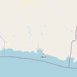
Map view of Jiwani Coastal Wetland

Use this park location map to pinpoint Jiwani Coastal Wetland in Pakistan, understand its exact geographic position, and read its mapped placement within the surrounding landscape more clearly.

Pigeon | © OpenStreetMap contributors

Location context for Jiwani Coastal Wetland

Balochistan

Visual reference guide to mangrove swamps, tidal lagoons, and protected coastal habitats

Jiwani Coastal Wetland Photos and Landscape Scenery Exploration

Visual records capture the distinctive terrain of Jiwani Coastal Wetland, revealing the sharp contrast between arid coastal hills and water-rich mangrove ecosystems. Photographic documentation offers clear insight into vulnerable estuarine habitats, tidal lagoons, and protected wildlife environments along the shoreline.

A wide view of a coastal wetland area where numerous young mangrove saplings are planted in rows across a sandy tidal flat, with the open water visible in the distance under a pale sky.

Aerial photograph showing a winding river flowing across a flat, arid coastal landscape into the deep blue water of the sea.

A dense cluster of young mangrove saplings growing in a nursery, with vertical support posts visible in the background.

A wide, arid landscape under a clear sky, showing sparse desert-like vegetation in the foreground and patches of rocky, dead coral debris scattered across the sandy ground.

A wide shot of a dusty, unpaved path winding through a arid, rocky coastal landscape under a hazy sky, with the dark blue ocean visible in the distant horizon.

Park atlas

Compare adjacent coastal landscapes and regional protected habitats in southwestern Pakistan

Explore Other Parks Near Jiwani Coastal Wetland and Surrounding Protected Areas

Browsing other parks near Jiwani Coastal Wetland reveals the broader ecological spread of the Balochistan coast and nearby estuarine environments. Continuing across these protected landscapes provides valuable context for comparing coastal lagoons, mangrove forests, and marine habitats.
A watercolor painting of soft, layered hills in shades of green, yellow, and muted pink against a white background.
Marine protected areaBalochistan
About 208 km away#1 closest

East

Astola Island Marine Protected Area: Geography and Coastal Landscape in Balochistan

Remote island plateau and offshore protected ecosystem

Trace the fractured terrain and limestone cliffs of Astola Island, a significant marine protected area located off the coast of Balochistan. This uninhabited island serves as a critical habitat for seabirds, reptiles, and sea turtles, marking a rare convergence of geological and ecological importance within the northern Arabian Sea.

Area
6.7 km²
Established
2017
Relief
Upland
Climate
Arid
A soft watercolor illustration of a coastal landscape with rocky terrain in the foreground and a calm bay in the distance.
Wildlife reserveBalochistan
About 288 km away#2 closest

East

Ormara Turtle Beaches Wildlife Reserve: Mapping Coastal Protected Habitats in Balochistan

Coastal sandy terrain and protected marine nesting environments

Examine the geography of Ormara Turtle Beaches, a 10 km protected sandy coastline on the Arabian Sea. The reserve offers clear insights into the marine-focused ecosystems and arid landscape character found along the Balochistan Makran coast, serving as a primary site for turtle nesting research and coastal conservation mapping.

Area
24 km²
Established
2001
Relief
Lowland
Climate
Subtropical
National parkBalochistan
About 333 km away#3 closest

East

Hingol National Park: Pakistan's Unique Protected Landscape and Geological Atlas

Discover dramatic rock formations and coastal geography.

Hingol National Park stands as a monumental protected landscape within Balochistan, Pakistan, offering an unparalleled atlas view of geological diversity. Renowned for its hoodoos like the Princess of Hope and the Balochistan Sphinx, the park also features active mud volcanoes and striking coastal semi-desert terrain. The confluence of the Hingol River with the Arabian Sea creates important wetland habitats. This national park provides a rich context for exploring unique natural formations and regional geography, making it a significant point of discovery within Pakistan's protected areas.

Area
6,100 km²
Established
1988
IUCN
II
Relief
Mixed relief
A soft watercolor painting of a tropical coastal landscape featuring a calm bay, low rolling hills in the background, and clusters of palm trees.
Nature reserveMuscat Governorate
About 372 km away#4 closest

Southwest

Qurm Nature Reserve: Protected Mangrove Ecosystems and Coastal Geography in Muscat

Coastal wetlands and avian habitats of the Gulf of Oman

Qurm Nature Reserve serves as a critical protected landscape within the Muscat Governorate, preserving expansive mangrove forests and intricate tidal channels. The reserve functions as a hub for coastal biodiversity, supporting numerous migratory bird species and maintaining ecological health within a major urban center. Explore the mapped boundaries and natural features of this significant wetland protected area.

Area
1.72 km²
Established
1975
IUCN
IV
Relief
Lowland
A watercolor painting showing a wide coastal scene with green low-lying hills in the distance, a calm body of water in the middle, and varied vegetation in the foreground.
Nature reserveMuscat Governorate
About 400 km away#5 closest

West

Ad Dimaniyat Islands Nature Reserve: Protected Archipelago and Marine Biodiversity Map

Archipelago landscape and marine protected area in Muscat Governorate.

The Ad Dimaniyat Islands represent a critical nature reserve composed of nine distinct islands in the Gulf of Oman. The archipelago is known for its rare coral formations, nesting beaches for endangered sea turtles, and its role as a breeding site for various seabird species. This protected landscape combines complex underwater reef habitats with rocky and sandy terrain, forming a significant ecological zone within the Muscat Governorate.

Area
1 km²
Relief
Lowland
Access
Moderate access
Scope
Marine
Wildlife reserveOman
About 403 km away#6 closest

Southwest

Al Saleel National Park: A Protected Acacia Forest Wildlife Reserve in Oman

Explore its unique landscape and protected area geography.

Al Saleel National Park in Oman is distinguished by its exceptional acacia forest ecosystem, a scarce habitat type across the Arabian Peninsula. Covering 220 square kilometers, this wildlife reserve serves as a crucial sanctuary for at-risk species like the Arabian gazelle and the endemic Omani wild cat. Its landscape offers a compelling study of arid zone forest ecology and protected area management, providing valuable context for understanding Oman's commitment to natural heritage and conservation within its regional geography.

Area
220 km²
Climate
Arid
Scope
Terrestrial
Water
No major water
Protected areaBalochistan
About 448 km away#7 closest

East

Miani Hor Protected Area: Coastal Lagoon Mapping and Regional Geography in Balochistan

Coastal lagoon and unique mangrove wetland ecosystem

Miani Hor functions as a major tidal lagoon and protected wetland along the Balochistan coast. The area is defined by its extensive mangrove forests and connection to the Arabian Sea, providing a essential study in estuarine geography and wetland conservation within the Lasbela District.

Area
74.71 km²
Established
2001
Relief
Lowland
Scope
Mixed
A pale, minimalist watercolor painting showing soft green hills or islands against a light, misty horizon.
Marine protected areaBalochistan
About 488 km away#8 closest

East

Churna Island Marine Protected Area: Geography and Coastal Atlas of Balochistan

Mapping the coral reef systems and rocky island terrain

Churna Island represents a unique marine protected area located near the border of Balochistan and Sindh. Characterized by a desolate rocky surface, the true ecological value resides in its extensive submerged reef structures, which provide habitat for a vast array of coral species and pelagic fish. This atlas resource provides a structured look at the island's coastal geography and its growing role in regional marine conservation.

Area
0.6 km²
Established
2024
Relief
Upland
Climate
Subtropical

Common questions about visiting, size, designation, and location context for Jiwani Coastal Wetland

Jiwani Coastal Wetland FAQs for park facts, access, geography, and protected area context

Find quick answers about Jiwani Coastal Wetland, including protected-area facts, park geography, trail and visitor context, and how the park fits into its surrounding country and regional landscape.
MoriAtlas Explorer

Continue Your Protected Areas Search Across the Global Atlas

Deepen your exploration by continuing the structured search for national parks and protected areas worldwide. Utilize the comprehensive filtering capabilities to compare different conservation landscapes and refine your understanding of global park geography. Discover more about the distribution and characteristics of protected natural areas.

Global natural geography