

Mori Atlas logo
Nature reserveAd Dimaniyat Islands

A vital marine protected area in the Gulf of Oman featuring rare coral reefs and island habitats.

Ad Dimaniyat Islands Nature Reserve: Mapped Protected Archipelago and Coastal Geography

The Ad Dimaniyat Islands form a compact archipelago of nine islands located off the coast of the Muscat Governorate. This nature reserve supports unique marine biodiversity, including extensive coral reefs and nesting grounds for green and hawksbill sea turtles. Recognized as an Important Bird Area, the reserve provides critical breeding sites for rare seabirds across its diverse mix of rocky shores and sandy beaches.

protected islandsgulf of omanmarine reservecoral reefsea turtlesisland archipelago
A minimalist, stylized digital illustration depicting a coastal landscape with pale rocky cliffs, calm light-blue water, and a tall flagpole displaying a triangular flag on a headland.

Ad Dimaniyat Islands

Nature reserve

Park overview

Structured park overview, official facts, and landscape profile for Ad Dimaniyat Islands

Ad Dimaniyat Islands park facts, protected area profile, and essential visitor context

Review the core facts for Ad Dimaniyat Islands, including designation, size, terrain, visitor scale, habitats, and operating context in one park-focused overview.

About Ad Dimaniyat Islands

The Ad Dimaniyat Islands represent one of Oman's most distinctive marine and island protected areas. Located in the Gulf of Oman off the coast of Wilayat Al Seeb in the Muscat Governorate, the reserve lies about eighteen kilometres from Barka and approximately seventy kilometres west of Muscat. Although small, comprising nine islands totalling roughly one hundred hectares, the archipelago carries significant ecological weight because it concentrates coral reef, beach, and rocky island habitats in a confined marine setting.

The reserve is administered as a nature reserve under the supervision of Oman's Ministry of Environmental Protection and Climate Affairs, and visits require official approval. Access is tightly regulated, with a cap on group sizes and a maximum permitted stay, reflecting the islands' ecological sensitivity. Despite their modest size, the islands are referenced in Oman's environmental strategy as a showcase site for marine biodiversity protection and sustainable nature tourism.

The Ad Dimaniyat Islands also carry a strong historical resonance. The archipelago is identified with the Calaei Islands mentioned in the Periplus of the Erythraean Sea, an ancient maritime trading guide that linked the islands to the Phoenician trade city of Kalhat. This long historical footprint, combined with their ecological importance, gives the Dimaniyat a dual identity as both a natural sanctuary and a place with deep ties to the long maritime history of the Arabian Gulf and Gulf of Oman.

Quick facts and research context for Ad Dimaniyat Islands

The Ad Dimaniyat Islands are a nine-island nature reserve in the Gulf of Oman, administered by the Omani authorities through the Ministry of Environmental Protection and Climate Affairs and falling within the Muscat Governorate. The islands lie roughly eighteen kilometres off the coast near Barka, well to the west of the capital Muscat. They are recognised internationally by BirdLife International as an Important Bird Area because of their breeding seabird colonies.

The reserve protects both marine and terrestrial environments, including rare coral reef formations, sea turtle nesting beaches, and rocky island habitats used by resident and migratory birds. Local island names include Kharabah, Huyoot, Al Jabal Al Kabeer, Um Al Liwahah, and the three islands grouped as Al Jawn, preserving traditional geographical identity within the protected area.

Protection and recognition

Marine conservation scope and documented protected area framework details

Ad Dimaniyat Islands Protection Status and Marine Reserve Designation Facts

Ad Dimaniyat Islands preserves a documented marine conservation scope without imported international recognition sources. Marine protected area tracking provides structured governance records and baseline designation facts for the reserve.

Protection details

Protection scope
Marine
Transboundary protection
No
Park context

Deeper park guide and search-rich context for Ad Dimaniyat Islands

Ad Dimaniyat Islands history, landscape, wildlife, and travel context

Explore Ad Dimaniyat Islands through its history, landscape character, ecosystems, wildlife, conservation priorities, cultural context, and seasonal travel timing in a structured park guide built for atlas discovery and search intent.

Why Ad Dimaniyat Islands stands out

The Ad Dimaniyat Islands are best known for hosting rare coral reef communities in the Gulf of Oman and for serving as one of the region's most important sea turtle nesting sites, with both green and hawksbill turtles using the beaches. The archipelago also stands out as a breeding ground for several seabird species, including sooty gulls and several tern species, which is why BirdLife International has formally recognised the islands as an Important Bird Area. Equally important to the islands' identity is the way these marine and island habitats converge in a very small geographic area. Reefs, nesting beaches, and seabird cliffs exist side by side across just nine small islands, giving the reserve a compact but unusually varied ecological character for the Gulf of Oman.
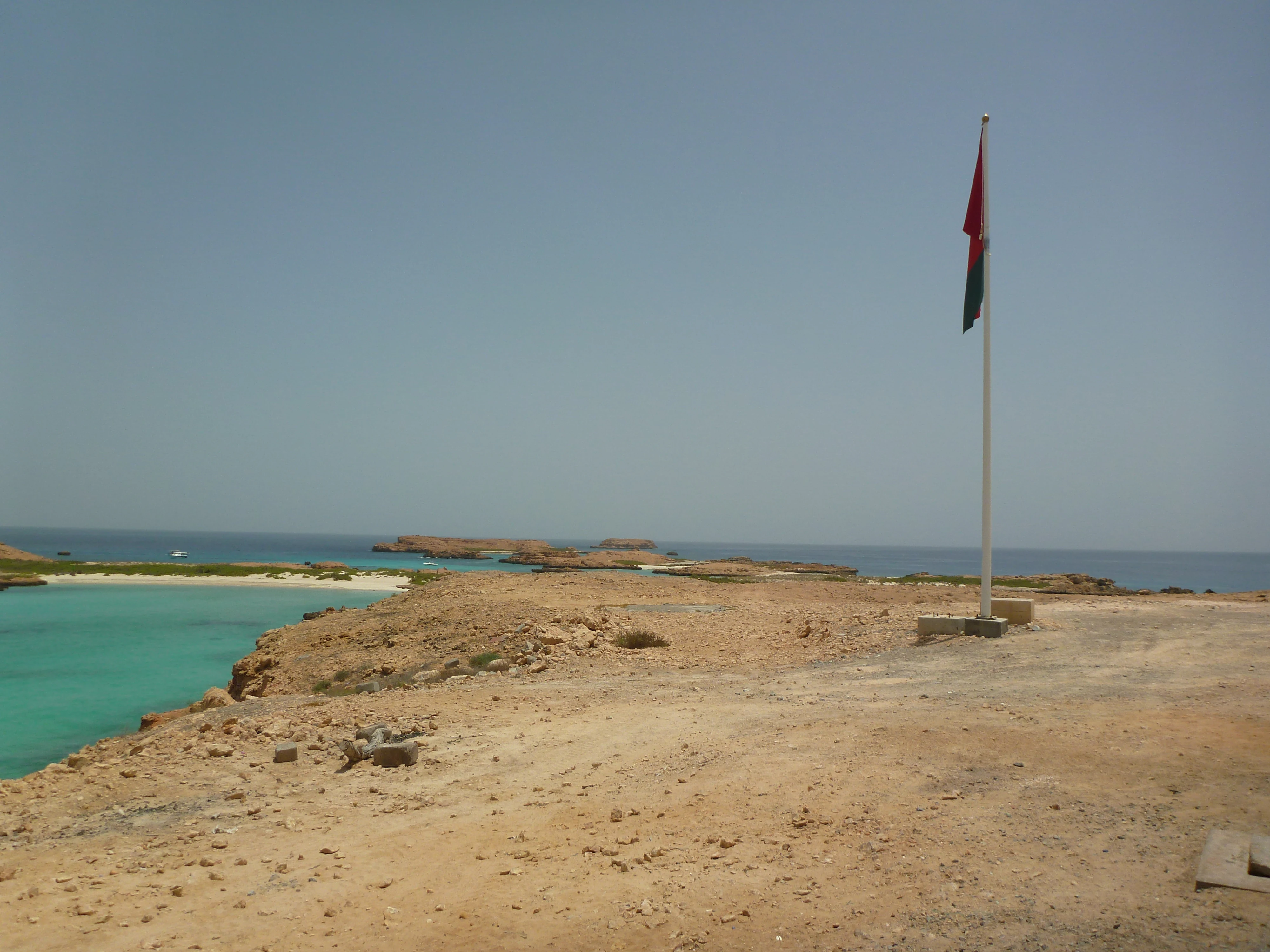
A wide shot of a rocky, arid island landscape surrounded by turquoise water, featuring an Omani flag on a white pole in the foreground.
The flag of Oman flying over the Ad Dimaniyat Islands nature reserve.

Ad Dimaniyat Islands history and protected-area timeline

The Ad Dimaniyat Islands have a documented history that reaches back well into antiquity. The archipelago appears in the Periplus of the Erythraean Sea, an ancient Greco-Roman trading manual that described maritime routes along the Arabian and Indian Ocean coasts. In this text the islands are referred to as the Calaei Islands, and the name is thought to derive from Kalhat, a former Phoenician trade city located north of Sur that served as a final staging point for trade between Arabia and India.

Some sources suggest that when Kalhat declined, residents of the city migrated inland to Kalat, whose name echoes that of the original coastal city. This historical connection gives the islands a place in the broader narrative of Indian Ocean maritime trade, even though their modern profile is dominated by their ecological role.

In the modern era, the islands were progressively recognised for their natural value and brought under formal environmental protection. The Ministry of Environmental Protection and Climate Affairs of Oman oversees the reserve, and access rules were revised to strengthen conservation, including tiered fees for visiting, diving, and camping. These changes reflect a shift from informal use toward managed nature reserve status, with the islands now treated primarily as a conservation asset rather than an open coastal destination.

Ad Dimaniyat Islands landscape and geographic character

The Ad Dimaniyat Islands form a compact archipelago of nine islands set in the Gulf of Oman. The islands vary in character, with some being low and sandy, suitable for sea turtle nesting, and others being more rocky and elevated, providing cliff and ledge habitat for nesting seabirds. Together they cover approximately one hundred hectares, a small footprint that nonetheless produces a varied coastal landscape above and below the waterline.

Locally recognised island names reflect this physical diversity. Kharabah, Huyoot, Al Jabal Al Kabeer, Um Al Liwahah, and the Al Jawn group each correspond to different landforms within the reserve. The proximity of the islands to the Omani mainland, around eighteen kilometres offshore near Barka, gives the archipelago a strong offshore-island character, with open-sea exposure shaping their beaches, vegetation, and shoreline geology.

The submerged landscape is just as important as the land itself. Surrounding the islands are coral reef formations described as including rare reef types, giving the seascape both ecological and visual significance. The combination of small islands, sandy beaches, rocky shores, and extensive reef habitat is what shapes the strong identity of the reserve in the Gulf of Oman.

Ad Dimaniyat Islands ecosystems, habitats, and plant life

The Ad Dimaniyat Islands protect a layered ecosystem that spans marine, shoreline, and terrestrial island environments. The most distinctive element is the network of coral reefs around the islands, described in conservation assessments as including reef formations that are considered rare within the Gulf of Oman. These reefs support the broader marine food web on which visiting and resident species depend.

Above the waterline, the islands carry sparse but ecologically important vegetation typical of arid offshore islands in the region. Sandy beaches provide nesting substrate for sea turtles, while rocky outcrops and cliffs offer secure ledges for breeding seabirds. The combination of beach, cliff, and reef habitat within a few kilometres makes the islands unusually rich in ecological transitions for such a small land area.

The reserve is also influenced by its wider marine and atmospheric setting. As islands in the Gulf of Oman, the Ad Dimaniyat sit within a regional ecosystem where seasonal productivity cycles, currents, and migratory pathways converge. This positioning helps explain why the islands function as both a year-round home for resident species and a seasonal destination for migratory birds and nesting marine turtles.

Ad Dimaniyat Islands wildlife and species highlights

Wildlife is the defining feature of the Ad Dimaniyat Islands. The reserve supports nesting populations of both green sea turtles and hawksbill sea turtles, which use the island beaches as egg-laying sites. The presence of two threatened turtle species on such a small island group gives the reserve strong international conservation significance.

The islands also host important seabird colonies. BirdLife International has designated the archipelago as an Important Bird Area because it supports breeding populations of sooty gulls, bridled terns, roseate terns, and white-cheeked terns. Sooty falcons are also recorded as breeding on or near the islands. These colonies make the archipelago a recognised site for seabird conservation in the Arabian region.

Beyond turtles and seabirds, the surrounding waters host reef-associated marine life supported by the coral systems around the islands. The combination of nesting beaches, breeding cliffs, and productive reef habitat creates a tightly linked wildlife community that depends on the protected status of the entire reserve, not just individual islands.

Ad Dimaniyat Islands conservation status and protection priorities

The Ad Dimaniyat Islands are managed as a formal nature reserve under Oman's environmental protection framework, with the Ministry of Environmental Protection and Climate Affairs responsible for oversight. Access to the islands requires ministerial approval, and stay limits and group size caps are imposed to minimise pressure on nesting beaches, seabird colonies, and reef habitat. These regulations reflect the high ecological sensitivity of the reserve despite its small size.

International recognition strengthens the reserve's conservation profile. BirdLife International has classified the archipelago as an Important Bird Area, an acknowledgement that supports habitat protection for breeding terns, gulls, and sooty falcons. The islands' coral reefs, including rare reef formations, are another central conservation focus, since reef ecosystems in the Gulf of Oman are vulnerable to disturbance, sedimentation, and climate-related stress.

Fee structures for visitors, divers, and campers have been revised to align with conservation objectives. Charges differ between Omani residents and expatriates, and the pricing tiers for general visits, diving, and overnight stays help fund reserve management while discouraging casual or low-value use. This combination of regulated access, international recognition, and tiered visitor policy marks the Ad Dimaniyat as a managed conservation asset rather than an open-access coastal destination.

Ad Dimaniyat Islands cultural meaning and human context

The Ad Dimaniyat Islands carry cultural weight through their connection to ancient Indian Ocean trade. Identification with the Calaei Islands in the Periplus of the Erythraean Sea ties the archipelago to the broader maritime world described by Greco-Roman traders, and to Kalhat, a Phoenician-era port that linked Oman's coast with trade routes reaching into India. The naming link between Kalhat and the later Khanate of Kalat hints at population movement from the coast inland following Kalhat's decline.

In more recent Omani identity, the islands retain local names such as Kharabah, Huyoot, Al Jabal Al Kabeer, Um Al Liwahah, and the Al Jawn group. These names preserve a sense of place and tradition among coastal communities, even as the islands are primarily treated today as a protected natural area rather than a permanently inhabited cultural landscape.

Top sights and standout views in Ad Dimaniyat Islands

The Ad Dimaniyat Islands' strongest point of distinction is the convergence of three high-value ecological features on a very small land area: rare coral reefs in the Gulf of Oman, nesting beaches used by green and hawksbill sea turtles, and breeding seabird colonies recognised by BirdLife International as an Important Bird Area. Together they form a compact reserve with an outsized conservation profile.

Equally distinctive is the islands' layered history, from their mention in the Periplus of the Erythraean Sea to their current role as a managed nature reserve with regulated access. The blend of ancient trade-route significance and modern marine conservation gives the Ad Dimaniyat a dual identity that few small Gulf of Oman archipelagos share.

Best time to visit Ad Dimaniyat Islands

The character of a visit to the Ad Dimaniyat Islands is shaped by the Gulf of Oman climate, with cooler months offering the most comfortable conditions for both diving and island-based activities. Sea conditions tend to be calmer and visibility around the reefs more favourable outside the peak summer heat, which also tends to align more closely with the cooler, less humid part of the year along the Omani coast.

Because the islands are also a nesting site for sea turtles and breeding ground for several seabird species, the timing of a visit affects what wildlife activity is most likely to be observed. Turtle nesting and seabird breeding cycles strongly influence the seasonal ecological character of the reserve, so visitors interested in these features should plan around the relevant natural calendar rather than only weather preferences. Access rules, including approval from the Ministry of Environmental Protection and Climate Affairs, apply year-round.

Monthly climate preview

Long-term average temperature and precipitation patterns across representative coordinates

Ad Dimaniyat Islands Climate Normals and Measured Monthly Temperature Ranges

Representative coordinates for Ad Dimaniyat Islands record measured long-term monthly temperatures ranging from moderate winter averages to high summer peaks alongside minimal precipitation. Detailed monthly climate normals provide broader context for studying annual weather patterns across the protected area.
Annual mean28 °C
22 °C33 °C
Jan22°
Feb23°
Mar24°
Apr28°
May32°
Jun33°
Jul32°
Aug31°
Sep31°
Oct30°
Nov27°
Dec24°
Warmest month
June

32.9 °C

Coolest month
January

22.2 °C

Wettest month
March

0.8 mm/day

Driest month
May

0.1 mm/day

Park location guide

Geography guide, regional context, and park location map for Ad Dimaniyat Islands

Ad Dimaniyat Islands park geography, regions, and map view in Oman

Understand where Ad Dimaniyat Islands sits in Oman through a broader geographic reading of the surrounding landscape, nearby location context, and its mapped position within the national park landscape.

How Ad Dimaniyat Islands fits into Oman

Oman, officially the Sultanate of Oman, is a country in the southeastern Arabian Peninsula. It borders Saudi Arabia, the UAE, and Yemen, and has coastline along the Arabian Sea and Gulf of Oman. Ruled by the Al Bu Said dynasty since 1744, it is the oldest independent state in the Arab world and was historically a regional power controlling territory across the Persian Gulf to East Africa.

Wider geography shaping Ad Dimaniyat Islands in Oman

Oman occupies the southeastern Arabian Peninsula in West Asia. It shares land borders with Saudi Arabia, the UAE, and Yemen. The country has coastal access to the Arabian Sea to the southeast and the Gulf of Oman to the northeast. The Hajar Mountains run through the northern region, while the interior consists of desert plains and rocky plateaus. The Musandam Peninsula is an exclave separated from the rest of Oman by UAE territory.

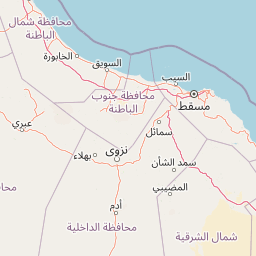
Map view of Ad Dimaniyat Islands

Use this park location map to pinpoint Ad Dimaniyat Islands in Oman, understand its exact geographic position, and read its mapped placement within the surrounding landscape more clearly.

Pigeon | © OpenStreetMap contributors

Location context for Ad Dimaniyat Islands

Muscat Governorate

Visual reference guide to marine habitats, coral reefs, and island topography

Ad Dimaniyat Islands Photos and Protected Landscape Scenery

Visual documentation captures the varied coastal terrain, sandy nesting beaches, and fragile coral reef environments of Ad Dimaniyat Islands. Examining these protected marine habitats provides clear insight into the ecological character of the archipelago.

A wide shot of a rocky, arid island landscape surrounded by turquoise water, featuring an Omani flag on a white pole in the foreground.

Park atlas

Compare adjacent coastal landscapes and regional conservation areas in the Gulf of Oman

Explore Parks Near Ad Dimaniyat Islands and Surrounding Marine Protected Areas

Browse protected areas and marine reserves situated near Ad Dimaniyat Islands to examine broader ecological patterns across the region. Extending the geographic comparison reveals connected coastal habitats and alternative island ecosystems throughout the surrounding waters.
A soft watercolor painting of a tropical coastal landscape featuring a calm bay, low rolling hills in the background, and clusters of palm trees.
Nature reserveMuscat Governorate
About 48 km away#1 closest

Southeast

Qurm Nature Reserve: Protected Mangrove Ecosystems and Coastal Geography in Muscat

Coastal wetlands and avian habitats of the Gulf of Oman

Qurm Nature Reserve serves as a critical protected landscape within the Muscat Governorate, preserving expansive mangrove forests and intricate tidal channels. The reserve functions as a hub for coastal biodiversity, supporting numerous migratory bird species and maintaining ecological health within a major urban center. Explore the mapped boundaries and natural features of this significant wetland protected area.

Area
1.72 km²
Established
1975
IUCN
IV
Relief
Lowland
A watercolor painting depicting a soft-toned mountain landscape with muted greens, pinks, and yellows, showing rolling hills and gentle peaks.
Nature reserveAd Dakhiliyah Governorate
About 108 km away#2 closest

Southwest

Jebel Akhdar Mountains Nature Reserve: An Atlas of Oman's High Altitude Protected Landscapes

Geographic analysis of the Ad Dakhiliyah mountain massif

The Jebel Akhdar Mountains represent a critical protected nature reserve defined by dramatic limestone cliffs, deep wadis, and centuries of terraced agriculture. This elevated massif within the Ad Dakhiliyah Governorate sustains a rare montane ecology that serves as a cornerstone of regional Omani geography and environmental conservation.

Established
2011
Relief
Mountain
Climate
Arid
Access
Moderate access
Wildlife reserveOman
About 201 km away#3 closest

Southeast

Al Saleel National Park: A Protected Acacia Forest Wildlife Reserve in Oman

Explore its unique landscape and protected area geography.

Al Saleel National Park in Oman is distinguished by its exceptional acacia forest ecosystem, a scarce habitat type across the Arabian Peninsula. Covering 220 square kilometers, this wildlife reserve serves as a crucial sanctuary for at-risk species like the Arabian gazelle and the endemic Omani wild cat. Its landscape offers a compelling study of arid zone forest ecology and protected area management, providing valuable context for understanding Oman's commitment to natural heritage and conservation within its regional geography.

Area
220 km²
Climate
Arid
Scope
Terrestrial
Water
No major water
Nature reserveUnited Arab Emirates
About 215 km away#4 closest

Northwest

Khor Kalba Nature Reserve: UAE Coastal Wetland and Mangrove Ecosystem Discovery

Mapped boundaries and regional landscape context for this Sharjah nature reserve.

Khor Kalba Nature Reserve showcases a rare and ecologically significant mangrove ecosystem on the eastern coast of the United Arab Emirates. This protected area features a dynamic intertidal landscape of creeks and lagoons vital for coastal conservation. Understanding its unique halophytic vegetation and bird habitats provides critical insight into the UAE's efforts to preserve its limited natural wetland environments and their distinctive geography.

IUCN
IV
Scope
Terrestrial
National parkUnited Arab Emirates
About 252 km away#5 closest

Northwest

Wadi Wurayah National Park National Park: Mapped Protected Landscape and Geographic Context

Explore the mapped boundaries and regional geography of Wadi Wurayah National Park.

Wadi Wurayah National Park stands as a significant national park, offering a focused area for exploring protected lands. This page provides essential details about its landscape characteristics and geographic positioning, framed for atlas-driven discovery. Understand the park's protected-area identity and its contribution to regional geographic context, making it a valuable entry for anyone mapping natural landscapes or investigating conservation areas.

Nature reserveDubai
About 269 km away#6 closest

Northwest

Dubai Desert Conservation Reserve: Nature Reserve, Mapped Geography, and Protected Landscape Context

Explore the natural terrain and conservation atlas of this UAE protected area.

This page details the Dubai Desert Conservation Reserve, a designated nature reserve situated within the geographic scope of Dubai, United Arab Emirates. Dive into its mapped boundaries, understand its role as a protected landscape, and gain insight into its unique natural terrain. MoriAtlas provides structured data to explore the park's place within regional geography and the broader atlas of protected areas.

Area
225 km²
Established
2003
Relief
Lowland
Climate
Arid
Nature reserveEmirate of Dubai
About 285 km away#7 closest

Northwest

Al Wohoosh Desert Conservation Reserve Nature Reserve: Mapped Protected Landscape

Desert terrain and geographic context in the Emirate of Dubai.

Delve into the Al Wohoosh Desert Conservation Reserve, a key protected natural area situated in the Emirate of Dubai. This entry focuses on its mapped geography, showcasing the desert landscape and its protected boundaries. Gain structured insights into its role as a nature reserve and its contribution to understanding regional conservation landscapes and mapped terrain.

Area
15.06 km²
Established
2014
Relief
Lowland
Climate
Arid
Nature reserveDubai
About 294 km away#8 closest

West

Al Marmoom Desert Conservation Reserve: Nature Reserve and Desert Landscape in Dubai

Mapped Geography and Protected Area Context

Explore the Al Marmoom Desert Conservation Reserve, a designated nature reserve located near Dubai. This protected area is crucial for understanding the region's desert geography and landscape. MoriAtlas provides detailed mapping and geographic context, allowing for in-depth study of its protected boundaries and its significance within the UAE's conservation landscape.

Area
0.4 km²
Established
2018
Relief
Lowland
Climate
Arid

Common questions about visiting, size, designation, and location context for Ad Dimaniyat Islands

Ad Dimaniyat Islands FAQs for park facts, access, geography, and protected area context

Find quick answers about Ad Dimaniyat Islands, including protected-area facts, park geography, trail and visitor context, and how the park fits into its surrounding country and regional landscape.
MoriAtlas Explorer

Continue Your Protected Areas Search Across the Global Atlas

Deepen your exploration by continuing the structured search for national parks and protected areas worldwide. Utilize the comprehensive filtering capabilities to compare different conservation landscapes and refine your understanding of global park geography. Discover more about the distribution and characteristics of protected natural areas.

Global natural geography