
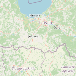
Natural springs
Park geography
Detailed analysis of park dimensions, terrain features, and regional landscape context.
Geographic Profile and Mapped Boundaries of Ķemeri National Park in Latvia
This geographic profile details the physical scope and natural characteristics of Ķemeri National Park. Explore the park through structured boundary data, which spans 381.65 square kilometers, and review regional terrain classifications. The analysis includes logged natural features, such as distinct lakes, rivers, springs, and wetland systems found within the protected area.
Latvia's wetland wilderness of bogs, sulfur springs, and lagoons
Ķemeri National Park
Ķemeri National Park is a protected area located in western Latvia, just west of the coastal city of Jūrmala. Established in 1997, it stands as the third-largest national park in Latvia, encompassing a diverse landscape of forests, mires, lakes, and coastal wetlands. The park is centered around the vast Great Ķemeri Bog, one of the largest raised bogs in the Baltic region, which forms the ecological heart of the reserve. Beyond its peatland landscapes, the park protects a network of lagoon-type lakes formed during the Littorina Sea period, extensive wetland systems, and the famous sulfur springs and therapeutic muds that have drawn visitors seeking healing for centuries. The combination of unique geological conditions, diverse habitats, and the legacy of spa tourism makes Ķemeri a distinctive protected area in Latvia's natural heritage.
- Location
- Latvia
- Park type
- National park
- Established
- 1997
- Area
- 381.7 km²
Location overview
Administrative boundaries and geographic status within Latvia
Geographic Location and Country Setting of Ķemeri National Park
Ķemeri National Park is situated entirely within the sovereign borders of Latvia. The protected area operates under a single national jurisdiction and does not contain transboundary, coastal, marine, or island territories.
- Countries
- Latvia
- Primary location
- Latvia
- Geographic setting
- Inland
Boundary and coordinates
Tracking total area and geographic coordinates across land and marine zones
Mapping the Boundaries and Spatial Limits of Ķemeri National Park
Mapped boundary lines illustrate how the protected territory of Ķemeri National Park sits within the regional landscape. Accompanying spatial data points detail land and marine areas, coordinate limits, and center coordinates.
- Boundary area
- 369.3 km²
- Boundary perimeter
- 169.6 km
- Northernmost point
- 57.0521° N
- Southernmost point
- 56.7926° N
- Easternmost point
- 23.631° E
- Westernmost point
- 23.2509° E
- Geographic centre
- 56.9299° N, 23.454° E
- North–south span
- 28.9 km
- East–west span
- 23.1 km
Terrain and natural features
Lowland relief classification and localized hydrographic network
Ķemeri National Park Terrain and Recorded Natural Features
Recorded lowland terrain data outlines internal wetlands, rivers, and springs across the protected landscape. Linked feature cards supply official types, names, and spatial relationships for each mapped element.
Selected named natural features
Rivers
Vanzārīte
Rivers
Samulomi
Rivers
Slampe
Streams
Vēršupīte
Wetlands
Smārdes purvs
Environmental setting
Boreal climate zones, lowland relief, and extensive wetland habitats across the terrain
Environmental Setting and Classification Profile for Ķemeri National Park
Recorded landscape features and habitat classifications outline the foundational physical setting of the protected terrain. Structured categories connect directly to related geographic contexts within the broader park network.
- Relief
- Lowland
- Climate
- Boreal
- Water
- Major water bodies
- Forest cover
- Mostly forested
- Seasonality
- Year-round
Landscape features
Bog · Forest · Wetland · Lakes · Rivers
Habitat types
Temperate coniferous forest · Boreal forest · Wetland · Peatland · Riverine habitat · Lacustrine habitat
Park atlas
Trace the regional spread of protected landscapes, comparing wetland, forest, and coastal ecosystems near Ķemeri National Park.
Explore Other Protected Areas and National Parks Near Ķemeri National Park
Browse a curated list of national parks and protected areas near Ķemeri National Park, discovering nearby wetland, forest, and coastal ecosystems across Latvia. Compare diverse protected landscapes, trace their geographic spread, and deepen your atlas understanding of conservation zones surrounding the Baltic region.
National parkLatvia
66 km away#1 closest
Northeast

Gauja National Park: Latvia's Largest National Park Atlas and Protected Landscape
Mapped terrain and diverse natural heritage in Vidzeme.
As Latvia's largest national park, Gauja offers a deep dive into a protected landscape defined by the ancient Gauja River valley and its spectacular Devonian sandstone cliffs. This page provides essential geographic context and atlas-style information, detailing the park's mapped boundaries, unique geological formations, and the rich tapestry of natural and cultural heritage that makes it a cornerstone of the region's protected lands. Explore the varied terrain, from river valleys to rolling uplands, all within a meticulously mapped conservation area.
- Area
- 917.87 km²
- Established
- 1973
- IUCN
- II
- Relief
- Mixed relief
Nature reserveAkmenė District Municipality
About 69 km away#2 closest
Southwest

Kamanų valstybinis gamtinis rezervatas: Mapped Bog Systems and Protected Forest Landscapes
Geographic reference and protected habitat in Akmenė District Municipality
Deepen your understanding of Kamanų valstybinis gamtinis rezervatas, an IUCN Category Ia protected area in Lithuania. Trace the boundaries of its iconic raised bog, mineral islands, and deep spruce woodlands that define this significant northern regional landscape.
- Area
- 39.35 km²
- Established
- 1979
- IUCN
- Ia
- Relief
- Lowland
National parkLatvia
83 km away#3 closest
Northwest
Slītere National Park: Latvia's Protected Coastal Landscape with Blue Hills and Bird Flyways
Explore the unique terrain and protected geography of this Baltic national park.
Slītere National Park represents a distinctive protected landscape on Latvia's Courland Peninsula, celebrated for its ancient geological formations like the Blue Hills (Zilie Kalni) and its role as a crucial bird migration corridor. The park's geography encompasses varied dune systems, wetland habitats, and rich broadleaf forests, offering a unique mapped environment. Discover the park's protected area boundaries and its significance within the regional Baltic geography, highlighting its unique ecosystem features and landscape context.
- Area
- 164.14 km²
- Established
- 2000
- IUCN
- II
- Relief
- Mixed relief
National parkLithuania
113 km away#4 closest
Southwest
Žemaitija National Park: Mapped Glacial Terrain and Samogitian Protected Landscape
Explore protected areas and natural geography in Northwestern Lithuania.
Žemaitija National Park is a protected natural reserve in Lithuania, defined by its distinctive glacially sculpted landscape. This park preserves over 217 square kilometers of hilly terrain, featuring significant lake systems like Lake Plateliai and substantial forest cover interspersed with wetlands. Users can explore the park's unique topographic character, its mapped geographic features, and its role as a vital protected area within the Samogitian region, offering a rich context for atlas-based discovery.
- Area
- 217.54 km²
- Established
- 1991
- IUCN
- II
- Relief
- Highland
Biosphere reserveAnykščiai District Municipality
152 km away#5 closest
Southeast
Šimonių Giria Biosphere Reserve in Anykščiai District Municipality, Lithuania
Protected forest massif and glacial landscape mapping
Šimonių giria stands as a prominent biosphere reserve in northern Lithuania, offering an expansive, pine dominated woodland defined by post glacial sands, extensive peat bogs, and a network of interior lakes. This structured overview details the park geographical features, from its role in the Natura 2000 network to its critical function as a biodiversity monitoring site within the Anykščiai District Municipality.
- Area
- 232.61 km²
- Established
- 2004
- Relief
- Lowland
- Climate
- Temperate
Marine protected areaSaare County
157 km away#6 closest
Northwest

Vilsandi National Park: Marine Protected Area Atlas and Archipelago Geography
Explore the protected landscape of Western Saaremaa's coast.
Vilsandi National Park is an integral part of Saare County's protected lands, recognized as a significant marine protected area. This page offers an atlas-style exploration of its geography, focusing on the distinctive archipelago terrain, coastal formations along Saaremaa's western edge, and its vital importance as a stopover for migratory birds. Understand the park's mapped boundaries and its place within the broader Baltic Sea ecosystem through detailed geographic context.
- Area
- 241 km²
- Established
- 1957
- IUCN
- II
- Relief
- Lowland
Biosphere reserveLithuania
About 167 km away#7 closest
Southeast
Taujėnų, Užulėnio miškų biosferos poligonas: Protected Forest Landscapes of Lithuania
Central Baltic lowland conservation territory
Spanning central Lithuania, this biosphere reserve preserves a vast mosaic of deciduous, coniferous, and mixed forest lands. The territory supports high-quality bird habitats through disciplined forestry practices and the protection of complex wetland and peatland systems, making it a reference site for lowland forest conservation.
- Area
- 44.19 km²
- Established
- 2004
- Relief
- Lowland
- Climate
- Temperate
National parkViljandi County
168 km away#8 closest
Northeast
Soomaa National Park: Estonia's Wilderness Wetland Landscape Atlas
Explore mapped protected peat bogs and dynamic floodplains in Viljandi County.
Soomaa National Park is a protected wilderness area in Estonia renowned for its extensive peat bog systems and unique floodplains. This national park, located primarily in Viljandi County, showcases some of Europe's largest intact wetland landscapes, characterized by seasonal floods that transform the terrain into vast aquatic environments. MoriAtlas provides detailed geographic context for Soomaa, allowing for exploration of its protected boundaries and landscape features within the broader atlas of European natural areas.
- Area
- 359 km²
- Established
- 1993
- IUCN
- II
- Relief
- Lowland
MoriAtlas Explorer
Continue Your Atlas Exploration of Ķemeri National Park's Unique Bog and Wetland Geography
Delve deeper into the structured geographic context of Ķemeri National Park. Understand its specific wetland ecosystems, mapped park boundaries, and relation to the surrounding regional terrain. MoriAtlas facilitates this exploration, providing detailed insights into the natural landscapes and protected areas vital for a comprehensive geographic understanding.
Browse next
Global natural geography
Explore related park routes
Explore MoriAtlas Global ParksBrowse All MoriAtlas ParksGlobal Park Map DiscoveryMoriAtlas: Browse All CountriesBrowse All MoriAtlas ContinentsNational Park Environment AtlasGrand Canyon National Park AtlasYellowstone National Park AtlasYosemite National Park Atlas and GeographySerengeti National Park AtlasGalápagos National Park Protected LandscapeBanff National Park Geography and AtlasKruger National Park Atlas EntryUluṟu-Kata Tjuṯa National Park AtlasExplore Uluru-Kata Tjuta National Park GeographyPlitvice Lakes National Park AtlasFiordland National Park Protected LandscapeGreat Smoky Mountains National Park AtlasAfghanistan National Parks and Protected AreasAlbania National Parks and Protected AreasAlgeria National Parks and Protected AreasAmerican Samoa National Parks and Protected AreasAndorra National Parks and Protected AreasAngola National Parks and Protected AreasAntarctica National Parks and Protected AreasAntigua and Barbuda Park List