Mori Atlas logo
State or regional parkKing George VI Provincial Park

Examining the ecological significance of riparian forest habitats within the Kootenay Boundary region

King George VI Provincial Park: A Protected Old Growth Cottonwood Landscape in British Columbia

King George VI Provincial Park preserves a rare and ecologically distinct stand of mature black cottonwood trees in southeastern British Columbia. While the site originated as a roadside facility, it has transitioned into a passive conservation pocket that serves as vital habitat for cavity nesting birds including barred owls and pileated woodpeckers. This protected area stands out as an island of mature deciduous canopy within a working landscape, offering a window into the rare riparian forest structure of the Kootenay Boundary corridor.

provincial parkold-growth forestblack cottonwoodriparian habitatcavity-nesting birdsKootenay Boundary

King George VI Provincial Park

State or regional park

Park overview

Structured park overview, official facts, and landscape profile for King George VI Provincial Park

King George VI Provincial Park park facts, protected area profile, and essential visitor context

Review the core facts for King George VI Provincial Park, including designation, size, terrain, visitor scale, habitats, and operating context in one park-focused overview.

About King George VI Provincial Park

King George VI Provincial Park is a small but ecologically distinctive provincial park in southeastern British Columbia, situated within the Kootenay Boundary regional district near Rossland and along BC Highway 22, which connects the area to the United States border. Despite its modest footprint, the park occupies a clear place in the network of protected areas administered by BC Parks. It was created with a commemorative purpose, marking the coronation of King George VI in 1937, and it served in its early decades as a roadside rest and campground for travellers crossing into Canada.

Over time the role of the park shifted. Its roadside facilities were repeatedly vandalized and BC Parks ultimately removed them, leaving the site without amenities, camping areas, or formal trails. This de-development has effectively transformed the park into a passive conservation area, and its contemporary significance lies less in recreational infrastructure than in what grows on the ground. The defining feature is a stand of old-growth Populus trichocarpa, the black cottonwood, a species typically associated with lowland and riparian environments. The presence of mature individuals of this size and age is increasingly uncommon in the region, where frontier-era logging, agricultural clearing, and modern land use have reduced the extent of large cottonwood forest.

What makes the park stand out is the way its old trees interact with the surrounding human landscape. The cottonwoods form a continuous canopy that visually and ecologically separates the park from adjacent mixed-use lands, creating an interior where light, moisture, and microclimate conditions differ noticeably from the open highway corridor beyond. This buffered setting supports a community of cavity-nesting birds that depend on large decaying trees for nest sites, including barred owls, pileated woodpeckers, and red-naped sapsuckers. The combination of continuous canopy, decaying woody structure, and relative quiet gives the park a character closer to a small forest reserve than to a typical roadside recreation area.

For visitors, the park today is essentially a pull-off curiosity: a small protected pocket of land along a busy border highway, without marked trails, signage of note, or services. Its meaning is mostly ecological and historical rather than experiential. It is a record of mid-twentieth-century Canadian commemoration of the Crown, of the changes in how BC Parks manages small recreation sites, and of the value of old-growth cottonwood as habitat in a working landscape.

Quick facts and research context for King George VI Provincial Park

King George VI Provincial Park is located in the Regional District of Kootenay Boundary in southeastern British Columbia, near Rossland and the United States border along BC Highway 22. It is a small park, well under two hundred hectares in size, and is classified under IUCN Category III as a natural monument or feature. Established by Order in Council on May 3, 1937, it commemorates the coronation of King George VI and is administered by BC Parks.

The park contains no developed facilities and no formal trail system. Its ecological significance rests on its stands of old-growth black cottonwood, which shelter cavity-nesting birds such as barred owls, pileated woodpeckers, and red-naped sapsuckers. The site essentially functions as a small conserved forest pocket within an otherwise heavily used highway and border landscape.

Protection and recognition

Examining documented terrestrial protection parameters and administrative scope

King George VI Provincial Park Protection Status and Conservation Scope

King George VI Provincial Park holds a documented terrestrial protection status that outlines its established management scope and administrative parameters. Comprehensive records provide clear insight into the protected area designation without assuming external recognition sources or unverified conservation outcomes.

Protection details

Protection scope
Terrestrial
Transboundary protection
No
Park context

Deeper park guide and search-rich context for King George VI Provincial Park

King George VI Provincial Park history, landscape, wildlife, and travel context

Explore King George VI Provincial Park through its history, landscape character, ecosystems, wildlife, conservation priorities, cultural context, and seasonal travel timing in a structured park guide built for atlas discovery and search intent.

Why King George VI Provincial Park stands out

King George VI Provincial Park is best known for its stands of old-growth black cottonwood. Mature individuals of this species are unusual and ecologically significant in this part of southeastern British Columbia, and the dense, continuous canopy they create distinguishes the park from the broader mixed-use landscape that surrounds it. The cottonwoods also give the park its wildlife character. Their large, decaying trunks and limbs support cavity-nesting birds, including barred owls, pileated woodpeckers, and red-naped sapsuckers, three species whose presence underlines the conservation role of the park even though it is small in size.

King George VI Provincial Park history and protected-area timeline

King George VI Provincial Park has its origins in 1937, when it was established by Order in Council on May 3 of that year. The park's creation was explicitly tied to the coronation of King George VI, and like many contemporary small parks in British Columbia, it was meant to serve a dual civic and recreational function. At the time of its establishment, the park spanned roughly 162 acres, an area that reflected both the modest ambitions of its founding and the practical limits of the available land near the highway corridor.

The park's original role was practical. It was designed as a rest area and campground for travellers on BC Highway 22, a route that connected interior British Columbia to border crossings into the United States. In the pre-war and early post-war era, when long-distance automobile travel was expanding rapidly across the region, small roadside parks like King George VI filled an important service gap for motorists entering Canada. Its location near Rossland and the international boundary made it a logical stopping point for travellers moving through the Kootenay Boundary region.

Over the later decades of the twentieth century, the park's recreational role atrophied. Its facilities were repeatedly vandalized, and BC Parks eventually decided that the maintenance burden outweighed the value of keeping services at the site. The facilities were removed and the park was allowed to revert to a natural state, with no trails, campground, or interpretive infrastructure left behind. Today the park exists primarily as a small protected landscape of old-growth cottonwood forest whose administrative history is shaped as much by abandonment as by active management, and whose founding moment remains a useful reminder of how mid-twentieth-century British Columbia linked parks to broader civic commemoration.

King George VI Provincial Park landscape and geographic character

The landscape of King George VI Provincial Park is best understood as a small, forested pocket set within a broader corridor of highway, settlement, and working land in southeastern British Columbia. The terrain lies in the Kootenay Boundary region near Rossland, in an area shaped by the topographic transition between the interior wet belt and the more arid slopes of the Boundary country. Even though the park is flat enough and small enough to feel almost incidental along a busy highway, its interior conditions differ sharply from the surrounding landscape.

The defining visual feature of the park is its continuous canopy of old-growth black cottonwood. These large deciduous trees form a closed overhead cover that gives the park a noticeably darker, cooler, and quieter interior than the open road just metres away. Beneath the canopy, the ground layer reflects a typical riparian-to-mesic forest understory, with the structural decay of mature cottonwoods, including broken limbs, snags, and cavities, contributing to the site's physical texture. Because the park is narrow and tightly bordered by roadside and adjacent land uses, the transition from forest interior back to open landscape is abrupt and visually striking.

The park has no formal trails or topographic features of landscape-scale note, so its value as scenery lies in the contrast between the dense cottonwood grove and the busy, human-dominated surroundings rather than in dramatic landforms. Its geography is essentially that of a small conserved wedge of mature forest beside a highway, but the integrity of the canopy gives that wedge a quality quite different from the typical patch of roadside vegetation.

King George VI Provincial Park ecosystems, habitats, and plant life

Ecologically, King George VI Provincial Park functions as a small refuge of old-growth cottonwood forest in a region where such habitat has become less common. The park's defining ecological feature is its stand of mature Populus trichocarpa, the black cottonwood, a species that is strongly associated with lowland and riparian systems in British Columbia and that, when allowed to reach old growth, supports a distinctly different ecological community than younger or fragmented forests.

The continuous canopy does much of the ecological work in the park. It moderates light and temperature near the forest floor, retains moisture more effectively than open or broken canopy, and sustains conditions that favour shade-tolerant understory plants and a stable supply of coarse woody debris. The cycle of limb drop and trunk decay in mature cottonwoods also creates persistent structural features, including snags and cavities, that anchor the site's habitat value for wildlife species that depend on these features for nesting and feeding.

Although the park's overall size is small, its ecological role is amplified by the scarcity of comparable old-growth cottonwood stands in the surrounding landscape. In a working environment shaped by resource extraction, agriculture, and transportation corridors, the park reads as a compact but coherent patch of habitat that retains the structural and functional elements of a much larger cottonwood forest ecosystem.

King George VI Provincial Park wildlife and species highlights

Wildlife at King George VI Provincial Park is shaped by the site being a small, dense, mature-cottonwood forest bordered by more open and disturbed land. The most consistently documented wildlife theme is the use of the park's large cottonwoods by cavity-nesting birds, which depend on decaying trunks, snags, and limbs for nest sites. This makes the park's value to wildlife disproportionate to its size.

Among the species specifically associated with the park are the barred owl, a forest owl that requires mature deciduous or mixed forest with large trees and cavities, the pileated woodpecker, a large primary-cavity-nester whose excavations in turn benefit other cavity users, and the red-naped sapsucker, a smaller woodpecker that nests in dead wood and feeds on sap wells drilled into living trees. The presence of all three within a tiny protected area underlines how the structural complexity of old-growth cottonwoods translates directly into usable nesting habitat.

Beyond these species, the cool, shaded conditions beneath the cottonwood canopy support a sheltered understory environment that likely sustains a broader community of songbirds, small mammals, and insects typical of cottonwood-dominated forests in southeastern British Columbia. While the park does not draw attention as a major wildlife destination, its function as a quiet anchor of habitat within a heavily modified regional landscape gives it disproportionate ecological relevance.

King George VI Provincial Park conservation status and protection priorities

The conservation significance of King George VI Provincial Park lies in what it preserves rather than in how much land it covers. Although the park is small in size, it retains a stand of old-growth black cottonwood that is increasingly rare in the Kootenay Boundary region. Mature cottonwoods of the size and structural integrity found in the park are slow to replace once lost, because the species depends on floodplain and similar lowland conditions that have been heavily modified by human activity across the region.

Within BC Parks' protected-area portfolio, the park functions as a small natural-features reserve, classified under IUCN Category III as a natural monument or feature rather than as a wilderness or ecosystem-protection area. This framing matches what the park actually contains: not a large landscape of intact ecosystem, but a distinctive, locally important stand of mature trees embedded in a modified landscape. Its protected status secures that stand against further loss and provides a baseline for the ecological role of mature cottonwood in this part of British Columbia.

The park's history also illustrates a quieter form of conservation outcome. By removing vandalized facilities and letting the site revert to a natural state, BC Parks effectively shifted the park's management emphasis away from recreation and toward protection of the existing forest. The result is a small but functioning conservation area whose value rests on the integrity of its old-growth canopy and on the habitat that integrity supports, particularly for cavity-nesting birds.

King George VI Provincial Park cultural meaning and human context

King George VI Provincial Park carries a clear cultural layer in its name. The park was established by Order in Council on May 3, 1937, an explicit commemoration of the coronation of King George VI, who became monarch of the United Kingdom and the British Dominions that same year. In the context of the time, naming public spaces, including parks, after newly crowned monarchs was a common way of linking civic infrastructure to the Crown and to shared imperial identity, and King George VI Provincial Park fits within that broader pattern of mid-twentieth-century Canadian commemoration.

Aside from this founding moment, the park has little documented cultural practice attached to it. Unlike parks with deep Indigenous land-use histories or long-standing local traditions of recreation, King George VI is largely a commemorative artefact whose cultural meaning is concentrated in its naming and founding date rather than in ongoing community use. Its evolution from a roadside rest area to an unstaffed, uninterpreted natural reserve means that contemporary visitors are more likely to encounter it as a stretch of forest than as a place with visible cultural programming.

The park nonetheless remains a small marker of how British Columbia's early provincial-park system connected everyday travel infrastructure, like highway stops and campgrounds, with the symbolic life of the wider Commonwealth during the late 1930s.

Top sights and standout views in King George VI Provincial Park

King George VI Provincial Park is a small but unusually well-preserved example of old-growth black cottonwood forest in southeastern British Columbia, set in a location where this kind of mature riparian woodland has become rare. Its stand of mature Populus trichocarpa is the single most defining feature, shaping both the visual character of the site and its ecological function.

Equally distinctive is the park's quiet role as habitat for cavity-nesting birds, including barred owls, pileated woodpeckers, and red-naped sapsuckers, whose presence depends on the structural decay of large cottonwoods. Combined with its origins as a coronation memorial, its early use as a highway rest area, and its later transition into a passive conservation reserve, the park offers a compact example of how British Columbia's small parks can hold disproportionate ecological and historical weight.

Best time to visit King George VI Provincial Park

Because King George VI Provincial Park has no developed facilities, trails, or formal infrastructure, the experience of visiting it is largely about observing the forest along BC Highway 22 rather than using the park as a destination in its own right. Seasons in the Kootenay Boundary region follow a typical interior British Columbia pattern: warm, relatively dry summers in which the cottonwood canopy is fully leafed and shaded; cool, often wet autumns in which the yellowing and falling cottonwood leaves make the canopy change visible from the road; cold winters under snow; and a green spring in which understory plants come back to life under a slowly re-leafing canopy.

For visitors interested in viewing the park, late spring through early autumn is generally the most accessible period, when the road corridor is most reliably open and the forest canopy is at its fullest. That said, the park's defining wildlife features, including cavity-nesting birds, are most observable in the breeding season of late spring and early summer, while the structural qualities of old-growth cottonwood are visible year-round.
Monthly climate preview

Long-term temperature ranges and monthly precipitation averages across representative coordinates

King George VI Provincial Park Climate Normals and Annual Weather Patterns

Representative coordinates record distinct temperature variations and precipitation averages throughout the twelve-month cycle at King George VI Provincial Park. Analyzing the full climate dataset reveals detailed monthly averages that clarify long-term meteorological trends across the protected terrain.
Annual mean5 °C
-8 °C19 °C
Jan-8°
Feb-6°
Mar-2°
Apr
May10°
Jun14°
Jul19°
Aug19°
Sep13°
Oct
Nov-2°
Dec-8°
Warmest month
July

19.1 °C

Coolest month
December

-8.1 °C

Wettest month
November

2.5 mm/day

Driest month
August

0.6 mm/day

Park location guide

Geography guide, regional context, and park location map for King George VI Provincial Park

King George VI Provincial Park park geography, regions, and map view in Canada

Understand where King George VI Provincial Park sits in Canada through a broader geographic reading of the surrounding landscape, nearby location context, and its mapped position within the national park landscape.

How King George VI Provincial Park fits into Canada

Canada is a federal parliamentary constitutional monarchy spanning North America from the Atlantic to the Pacific and Arctic Oceans. With a population of over 41 million, it is officially bilingual in English and French at the federal level. The country gained independence from the United Kingdom through a gradual process culminating in 1982.

Wider geography shaping King George VI Provincial Park in Canada

Canada occupies the northern portion of North America, sharing its longest international border with the United States. The country extends from the Atlantic Ocean to the Pacific Ocean and northward into the Arctic Ocean, giving it the longest coastline of any nation.

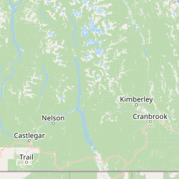
Map view of King George VI Provincial Park

Use this park location map to pinpoint King George VI Provincial Park in Canada, understand its exact geographic position, and read its mapped placement within the surrounding landscape more clearly.

Pigeon | © OpenStreetMap contributors

Location context for King George VI Provincial Park

British Columbia
Park atlas

Compare nearby national parks and regional conservation areas across southeastern British Columbia

Parks Near King George VI Provincial Park and Surrounding Protected Landscapes

Visitors exploring King George VI Provincial Park can continue browsing other protected areas situated throughout the surrounding Kootenay Boundary region. Expanding the geographic comparison reveals connected forest corridors and regional park habitats across southeastern British Columbia.
State or regional parkBritish Columbia
About 60 km away#1 closest

West

Jewel Lake Provincial Park: Geography and Protected Landscapes in British Columbia

A ridge-flanked valley lake with historic mining heritage

Jewel Lake Provincial Park preserves a narrow, forty-nine hectare freshwater ecosystem in the Boundary region of British Columbia. The area provides a detailed look at ridge-flanked mountain terrain and the historical mining landscape that defines this section of the West Kootenay-Boundary corridor.

Area
0.49 km²
Established
1981
IUCN
II
Climate
Temperate
Watercolor painting of a calm river winding through a forested landscape with soft hills in the background at sunset.
State or regional parkBritish Columbia
About 86 km away#2 closest

West

Kettle River Recreation Area: Protected Dry Belt Landscapes and River Geography in British Columbia

Mapping riparian corridors and southern interior ecological zones

Located within the Kootenay Boundary, Kettle River Recreation Area protects a rare intersection of dry ponderosa pine-bunchgrass communities and old growth cottonwood stands. The park creates a distinct geographic enclosure shaped by a sharp S-bend in the river, providing a significant reference point for dry-belt interior ecosystems within the broader British Columbia provincial park network.

Area
1.79 km²
Established
1972
IUCN
II
Relief
Upland
A soft watercolor illustration depicting a winding river flowing through a gentle landscape with distant rolling hills and scattered trees.
Protected areaWashington
About 105 km away#3 closest

South

Lake Roosevelt National Recreation Area: An Atlas of Washington Reservoir Landscapes

A sprawling protected region spanning the Columbia River corridor.

Lake Roosevelt National Recreation Area represents a massive, water-defined corridor in eastern Washington. The park preserves the 130-mile Franklin D. Roosevelt Lake, where steep basalt terrain meets arid shrub-steppe. This protected unit offers deep insight into the regional geography of the Columbia Plateau, featuring historical sites and river-system infrastructure that define the landscape's character.

Area
406.3 km²
Established
1946
Visitors
1.2M annual
Relief
Lowland
A pale, minimalist watercolor painting showing a soft green treeline along a riverbank with light mountain silhouettes in the distance.
State or regional parkBritish Columbia
About 128 km away#4 closest

West

Inkaneep Provincial Park: Mapped Geography and Protected Riparian Landscapes in British Columbia

Conserving riverine habitats and arid valley biodiversity in the Okanagan

Inkaneep Provincial Park occupies a distinct corridor along the Okanagan River, safeguarding vital riparian vegetation and cottonwood forests in one of Canada's driest regions. This protected area supports important ecological functions, ranging from salmon habitat restoration to providing refuge for rare bird species, representing a meaningful component of the south Okanagan geographic network.

Area
0.205 km²
Established
1956
IUCN
II
Relief
Lowland
A soft watercolor painting depicting rolling mountains in the background with a line of forest in the midground and open terrain in the foreground.
Protected landscapeMontana
About 130 km away#5 closest

Southeast

Kootenai National Forest: Geography and Protected Land Map for Northwestern Montana

Northern Rockies mountain ranges and watershed analysis.

Spanning over two million acres, Kootenai National Forest represents a critical protected landscape in the Northern Rockies. This atlas entry details the interplay between the Cabinet Mountains, regional river systems like the Kootenai and Clark Fork, and the dense conifer forests that define this uniquely wet corner of Montana.

Area
8,900 km²
Established
1907
Relief
Mountain
Climate
Temperate
Protected landscapeBritish Columbia
About 130 km away#6 closest

Northwest

Graystokes Provincial Park: Geographic Overview of British Columbia Protected Wilderness

Exploring the Okanagan Highland plateau and alpine wetland systems

Graystokes Provincial Park functions as a key protected landscape in the British Columbia interior. This backcountry expanse is defined by its rolling plateau terrain, encompassing alpine wetlands, meadows, and riparian habitats set against a backdrop of Engelmann spruce and subalpine fir forests.

Area
119.58 km²
Established
2001
Relief
Highland
Climate
Alpine
A watercolor painting of a mountain landscape with soft-colored rolling hills, a green forest line, and foreground vegetation on a white background.
Protected landscapeWashington
About 160 km away#7 closest

West

Okanogan, Wenatchee National Forest: A Comprehensive Look at Washington's Protected Mountain Landscapes

Mapping ecological gradients and wilderness boundaries across the eastern Cascade Range

Spanning from the moist coniferous forests of the western Cascades to the arid plateaus of the Okanogan, this massive national forest protects an unmatched diversity of terrain. Explore the intricate geography of river-carved valleys, glacial cirques, and remote wilderness areas that characterize this critical environmental corridor in the Pacific Northwest.

Area
6,066.33 km²
Established
1911
Visitors
397K annual
Relief
Mountain
State or regional parkBritish Columbia
About 167 km away#8 closest

Northwest

Kalamalka Lake Provincial Park and Protected Area: Mapped Geography and Regional Context

A conservation landscape of the North Okanagan valley

Kalamalka Lake Provincial Park and Protected Area preserves 978 hectares of essential grassland and lakeshore habitats in British Columbia. The area features a complex mosaic of open meadows and mixed forest stands, offering a detailed perspective on the ecological transitions found within the Okanagan Valley. Its geography is defined by the shimmering turquoise waters of Kalamalka Lake, reflecting the unique interplay between seasonal mineral shifts and the surrounding arid terrain.

Area
9.78 km²
Established
1975
IUCN
II
Relief
Upland

Common questions about visiting, size, designation, and location context for King George VI Provincial Park

King George VI Provincial Park FAQs for park facts, access, geography, and protected area context

Find quick answers about King George VI Provincial Park, including protected-area facts, park geography, trail and visitor context, and how the park fits into its surrounding country and regional landscape.
MoriAtlas Explorer

Continue Your Protected Areas Search Across the Global Atlas

Deepen your exploration by continuing the structured search for national parks and protected areas worldwide. Utilize the comprehensive filtering capabilities to compare different conservation landscapes and refine your understanding of global park geography. Discover more about the distribution and characteristics of protected natural areas.

Global natural geography