Why Lag Badana National Park stands out
Lag Badana is best known as Somalia's first national park and serves as a critical refuge for the lesser kudu, a distinctive antelope species found in the region's forests. The park's designation as an Important Bird Area by BirdLife International reflects its significance for avian biodiversity. Its coastal forest habitats contain a remarkable concentration of endemic plant species, with approximately 20 unique to this area. The park also forms part of a broader Lion Conservation Unit, indicating its importance for East African lion populations. The combination of coastal wilderness, forest ecosystems, and large mammal conservation makes Lag Badana a distinctive protected area in the Horn of Africa.
Lag Badana National Park history and protected-area timeline
The establishment of Lag Badana National Park in the late 1980s marked a pioneering moment in Somalia's approach to environmental protection, as it became the first national park in the country's history. During this period, the Siad Barre government's Ministry of Tourism actively promoted tourism development in the southern coastal region, identifying the park's natural assets as a potential draw for visitors. The vision extended beyond the park itself, encompassing nearby coral reefs and islands as part of an integrated tourism zone. By 1989, new legislation was drafted to provide a legal framework for national parks, game reserves, and special reserves, with wildlife conservation oversight residing within the Ministry of Livestock, Forestry and Range's National Range Agency. The Department of Wildlife maintained an independent law enforcement unit created through presidential decree. Following the outbreak of civil war in 1991, all development and conservation activities at the park ceased, and the protected area entered a period of uncertain status. In August 2014, President Hassan Sheikh Mohamud announced new development initiatives that included assigning leadership of the national park to young managers, reflecting a contemporary effort to strengthen environmental preservation and explore potential tourism opportunities.
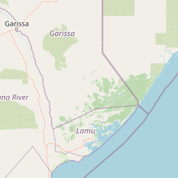
Lag Badana National Park landscape and geographic character
Lag Badana National Park encompasses a distinctive coastal landscape where terrestrial and marine environments meet along Somalia's southern shore. The terrain features a mix of forest-covered areas and more open woodland, with the coastal influence creating a unique ecological character distinct from Somalia's more arid interior regions. The park's position near Kismayo places it along a coastline characterized by sandy beaches and proximity to offshore islands that were originally envisioned as part of an integrated coastal tourism zone. The forests within the park, while not extensive by rainforest standards, represent significant wooded habitat in a region where forest cover is limited. These forest areas provide critical habitat for species like the lesser kudu and serve as refuges for plant endemism. The landscape transitions from coastal dunes and beach areas toward more vegetated inland zones, creating a gradient of habitats that contributes to the park's biological diversity.
Lag Badana National Park ecosystems, habitats, and plant life
The ecological character of Lag Badana National Park centers on its coastal forest ecosystems, which support remarkable plant diversity despite the challenging environmental context of southern Somalia. The park contains over 200 vascular plant species, a significant figure for a protected area in this part of East Africa. Of particular note is the presence of approximately 20 endemic plant species that are found nowhere else on Earth, making the park globally significant for plant conservation. The forest habitats provide essential ecosystem services and serve as the ecological foundation supporting the park's wildlife populations. The coastal setting influences vegetation patterns, creating a mix of species adapted to both terrestrial and maritime conditions. This combination of coastal influence and forest habitat makes Lag Badana an important ecological island in a region where natural habitat is increasingly under pressure.
Lag Badana National Park wildlife and species highlights
Lag Badana National Park provides crucial habitat for several notable wildlife species, with the lesser kudu standing out as one of the park's most distinctive mammals. This forest-dwelling antelope species finds suitable habitat in the park's woodland and forest areas, where it occupies a niche that has become increasingly restricted across its range. The park's designation as a Lion Conservation Unit since 2005 reflects its importance for East African lion populations, indicating that the area supports viable populations of this iconic large predator. The park's status as an Important Bird Area, recognized by BirdLife International, points to significant avian diversity, with the coastal location and varied habitats supporting bird communities that use the area for breeding, feeding, or as part of migratory routes. While detailed species inventories are limited in available documentation, the combination of forest, woodland, and coastal habitats creates conditions that support diverse wildlife assemblages.
Lag Badana National Park conservation status and protection priorities
Lag Badana National Park holds significant conservation importance for Somalia and the broader East African region, serving as the nation's flagship protected area. The park's designation as a Lion Conservation Unit since 2005 places it within a network of areas recognized as critical for maintaining viable lion populations in the wild, a species facing mounting pressures across Africa. Its recognition as an Important Bird Area by BirdLife International confirms international acknowledgment of its value for avian biodiversity, particularly for species of conservation concern. The presence of approximately 20 endemic plant species elevates the park's global conservation significance, as these species exist nowhere else and depend entirely on protection within this area. As Somalia's first national park, Lag Badana represents the country's foundational investment in biodiversity preservation and sets a precedent for conservation in a nation where protected area management faces considerable challenges following decades of civil unrest.
Lag Badana National Park cultural meaning and human context
Lag Badana National Park is located in the Lower Juba region, an area with historical significance for Somalia's coastal communities. The park's proximity to Kismayo, one of Somalia's major coastal cities, reflects the historical human presence in this coastal zone. While detailed cultural information about indigenous communities or traditional land use within the park itself is limited in available sources, the broader Lower Juba region has been inhabited by Somali peoples whose pastoral and maritime traditions shape the cultural landscape. The park's establishment in the 1980s represented a modern approach to conservation that sought to balance natural resource protection with tourism development, reflecting evolving attitudes toward protected areas in post-independence Somalia.
Top sights and standout views in Lag Badana National Park
Lag Badana National Park stands as Somalia's premier protected area, representing the nation's first and most established national park. The park's coastal forest habitats support unique biodiversity, including the lesser kudu and significant populations of East African lions. With approximately 20 endemic plant species found nowhere else on Earth, the park holds global conservation significance that extends beyond Somalia's borders. Its designation as both a Lion Conservation Unit and an Important Bird Area reflects international recognition of its ecological value. The park's position along the southern coast near the Kenyan border gives it a strategic location at the edge of Somalia's maritime territory.