
Streams
Park geography
Examine the regional terrain, mountain landscape characteristics, and natural features.
Lassen National Forest: Comprehensive Geographic Profile and Mapped Land Boundaries
This geographic profile details the physical scope of Lassen National Forest, covering 4,331.53 square kilometers of protected mountainous terrain in California. Explore mapped boundaries and internal environmental classifications including riverine systems, coniferous forests, and diverse peaks.

A vast volcanic and coniferous expanse in northeastern California, managed by the U.S. Forest Service.
Lassen National Forest
Lassen National Forest encompasses roughly 1,700 square miles of rugged terrain in northeastern California, situated between the Central Valley to the west, the Modoc Plateau to the east, and the Sierra Nevada to the south. Managed by the U.S. Forest Service, this vast protected landscape is characterized by extensive coniferous forests, cinder cones, ancient lava flows, and two major river systems. Originally established in 1905 as the Lassen Peak Forest Reserve, the area transitioned into a National Forest, serving as a critical source of timber products and a refuge for diverse wildlife. The forest shares a direct border with Lassen Volcanic National Park, expanding upon the volcanic and hydrothermal geography of the southern Cascades. Beyond its ecological importance, Lassen National Forest contains designated wilderness areas such as the Ishi, Caribou, and Thousand Lakes, preserving both natural ecosystems and significant chapters of California's pioneer and indigenous history.
- Location
- United States of America
- Park type
- Protected landscape
- Established
- 1905
- Area
- 4,331.5 km²
Location overview
Recorded country and regional administrative memberships in California
Lassen National Forest Geography and Regional Location Overview
Lassen National Forest occupies recorded locations across the United States of America and California. Administrative data tracks domestic regional memberships while excluding transboundary, coastal, island, and marine classifications.
- Countries
- United States of America
- Regions
- California
- Primary location
- California
- Geographic setting
- Inland
Boundary and coordinates
Interactive mapped geometry and derived spatial measurements
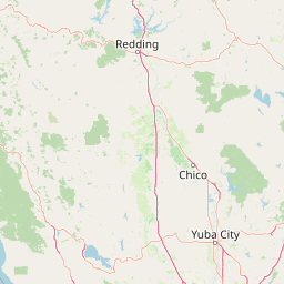
Lassen National Forest Boundary Map and Spatial Extent
Mapped boundary geometry provides clear spatial context for the protected landscape. Accompanying facts outline recorded area metrics, coordinate limits, and regional spans without legal survey claims.
- Boundary area
- 5,904.6 km²
- Boundary perimeter
- 1,868.4 km
- Northernmost point
- 41.3522° N
- Southernmost point
- 39.9257° N
- Easternmost point
- 120.5679° W
- Westernmost point
- 121.8757° W
- Geographic centre
- 40.5523° N, 121.3316° W
- North–south span
- 158.4 km
- East–west span
- 110.6 km
Terrain and natural features
Explore recorded peaks, lakes, and streams across protected lands
Lassen National Forest Mountain Terrain and Named Natural Features
Lassen National Forest features mountain terrain classifications with multiple recorded peaks, lakes, and streams located within the boundaries. Linked feature cards supply official names, types, and spatial relationships for each mapped natural formation.
Selected named natural features
Streams
China Creek
Peaks
Long Valley Mountain
1,370 m
Lakes
Long Lake
Lakes
North Divide Lake
Lakes
Seven Lakes
Environmental setting
Recorded habitat types, relief, water presence, and climate zone categories
Lassen National Forest Environmental Settings and Landscape Classifications
Recorded landscape and habitat classifications frame the physical setting across mountain relief, temperate forests, and major water systems. Individual categories link directly to broader protected area destinations and regional atlas records.
- Relief
- Mountain
- Climate
- Temperate
- Water
- Major water bodies
- Forest cover
- Dense forest cover
- Seasonality
- Seasonal
Landscape features
Mountains · Lakes · Rivers · Waterfalls · Forest · Volcano · Cave
Habitat types
Temperate coniferous forest · Montane forest · Riverine habitat · Lacustrine habitat
Park atlas
Compare adjacent volcanic terrain, mountain wilderness, and regional reserves
Explore Parks Near Lassen National Forest and Surrounding Protected Landscapes
Browse nearby national parks and protected areas sharing the volcanic geography of northeastern California. Continuing beyond Lassen National Forest reveals broader regional ecosystems and connected wilderness zones across the southern Cascades.
Wildlife reserveCalifornia
Park boundaries overlap#1 closest
Southwest

Ishi Wilderness Wildlife Reserve: Mapping the Volcanic Canyons of the Cascade Foothills
Geographic atlas of protected northern California wilderness and cultural landscapes.
Ishi Wilderness represents a crucial protected area in northern California, where volcanic geology meets a deep-rooted cultural history. Explore the mapped ridgelines, river canyons, and diverse oak woodland habitats that define this unique wildlife reserve and its role within the Cascade foothills.
- Area
- 167.29 km²
- Established
- 1984
- IUCN
- Ib
- Relief
- Mountain
National parkCalifornia
Park boundaries overlap#2 closest
West
Lassen Volcanic National Park: Protected Landscape Identity and Geographic Context
Discover the mapped boundaries and natural terrain of this California national park.
Gain a structured understanding of Lassen Volcanic National Park as a protected landscape. This detail page provides essential geographic context, focusing on the park's mapped boundaries and its specific terrain characteristics within California. It is designed for users seeking detailed information about the park's protected status and its placement within the broader atlas of natural areas, emphasizing its unique geographic identity and conservation significance.
- Area
- 430.8 km²
- Established
- 1916
- IUCN
- II
- Visitors
- 504.8K annual
Protected landscapeCalifornia
Park boundaries overlap#3 closest
North
Modoc National Forest: Protected Landscape and Warner Mountains Geography
High desert volcanic terrain in northeastern California
Modoc National Forest encompasses a massive expanse of volcanic plateaus and rugged mountain ridges in the northeastern corner of California. This protected area offers significant geographic variety, transitioning from arid sagebrush basins to lush, high-elevation conifer forests. It serves as a vital natural landscape, home to the South Warner Wilderness and large stands of old-growth timber, reflecting the unique geologic history of the regional lava flows.
- Area
- 6,695.09 km²
- Established
- 1904
- Relief
- Mountain
- Access
- Moderate access
Protected landscapeCalifornia
Park boundaries overlap#4 closest
Southeast
Plumas National Forest: Mapped Geography and Protected Landscape Features in California
Exploring the Sierra Nevada watershed and wilderness terrain
Plumas National Forest serves as a critical protected landscape in northern California, anchoring the headwaters of the Feather River system. This atlas entry details the forest's rugged canyons, high elevation mountain lakes, and significant old growth conifer stands that define its role within the northern Sierra Nevada ecosystem.
- Area
- 4,640 km²
- Established
- 1907
- Relief
- Mountain
- Climate
- Mediterranean

Protected landscapeCalifornia
Park boundaries overlap#5 closest
West
Shasta, Trinity National Forest: Mapping the Protected Landscapes of Northern California
Volcanic peaks, expansive reservoirs, and rugged mountain wilderness
Spanning over two million acres, Shasta, Trinity National Forest represents a major protected landscape in Northern California. The geography includes the iconic Mount Shasta volcano and the complex shoreline of Shasta Lake, while hosting expansive wilderness areas and diverse terrain ranging from oak-forested foothills to alpine meadows.
- Area
- 8,942.87 km²
- Established
- 1954
- Relief
- Mountain
- Climate
- Temperate
Wildlife reserveCalifornia
41 km away#6 closest
Northwest
Mount Shasta Wilderness: A Geographic Profile of California Volcanic and Alpine Landscapes
Mapping protected volcanic peaks and glacial ecosystems
Deeply explore the protected geography of Mount Shasta Wilderness, a 38,200-acre reserve in Northern California. This record details the park's stratovolcano foundations, glacial terrain, and forested corridors, offering a clear view of the complex landforms and boundary systems that define this significant high-elevation protected area.
- Area
- 155 km²
- Established
- 1984
- IUCN
- Ib
- Relief
- Mountain
Protected landscapeCalifornia
47 km away#7 closest
South
Tahoe National Forest: Exploring Protected Mountain Landscapes in the California Sierra Nevada
An atlas of granite river canyons and alpine ridge terrain
Tahoe National Forest defines a critical segment of the western Sierra Nevada, containing granite river canyons, numerous reservoirs, and summits reaching above 9,000 feet. This protected landscape acts as a vital headwater for California foothill communities and Nevada, hosting significant natural features like the Placer County Big Trees Grove and segments of the Pacific Crest Trail.
- Area
- 3,526.82 km²
- Established
- 1899
- Relief
- Mountain
- Climate
- Mediterranean
Protected landscapeCalifornia
61 km away#8 closest
West
Whiskeytown, Shasta, Trinity National Recreation Area: Geographic and Protected Landscape Overview
Mapped terrain across northern California reservoir units
Investigate the environmental character of Whiskeytown, Shasta, Trinity National Recreation Area, spanning from the expansive waters of Shasta Lake to the forested ridges of the Whiskeytown unit. This atlas entry details the interplay between large-scale reservoir management, riparian habitats, and the transition from Mediterranean chaparral to high-elevation conifer forests in California.
- Area
- 99,588 km²
- Established
- 1965
- IUCN
- V
- Visitors
- 1.5M annual
MoriAtlas Explorer
Explore the Geographic Boundaries and Terrain of Lassen National Forest
Continue your discovery of protected areas by examining the complex volcanic landscape of Lassen National Forest. This MoriAtlas destination provides clear insights into the terrain and ecological features defining this essential California mountain region. Deepen your understanding of regional geography through our structured park and wilderness mapping resources.
Browse next
Global natural geography
Explore related park routes
Explore MoriAtlas Global ParksBrowse All MoriAtlas ParksGlobal Park Map DiscoveryMoriAtlas: Browse All CountriesBrowse All MoriAtlas ContinentsNational Park Environment AtlasGrand Canyon National Park AtlasYellowstone National Park AtlasYosemite National Park Atlas and GeographySerengeti National Park AtlasGalápagos National Park Protected LandscapeBanff National Park Geography and AtlasKruger National Park Atlas EntryUluṟu-Kata Tjuṯa National Park AtlasExplore Uluru-Kata Tjuta National Park GeographyPlitvice Lakes National Park AtlasFiordland National Park Protected LandscapeGreat Smoky Mountains National Park AtlasAfghanistan National Parks and Protected AreasAlbania National Parks and Protected AreasAlgeria National Parks and Protected AreasAmerican Samoa National Parks and Protected AreasAndorra National Parks and Protected AreasAngola National Parks and Protected AreasAntarctica National Parks and Protected AreasAntigua and Barbuda Park List