
Streams
Park geography
Structured data on protected boundary geometry, mountain landscapes, and regional stream networks.
Comprehensive Geographic and Terrain Profile of the Lee Metcalf Wilderness in Montana
The Lee Metcalf Wilderness encompasses a vast 1029.07 square kilometer area of mountain terrain within Montana. This geographic profile details the protected boundaries and identifies key natural features such as Gallatin Peak, Alex Diekmann Peak, and various stream systems including the West Fork Beaver Creek and Monument Creek. Analyze the regional context of this alpine environment and its characteristic montane forests and alpine meadows.
Related tags
wilderness areaalpine mountainsRocky Mountainssubalpine forestsriver canyons
Montana's rugged alpine wilderness and a stronghold for grizzly bears in the northern Rockies
Lee Metcalf Wilderness
The Lee Metcalf Wilderness is a large, federally designated wilderness area in the northern Rocky Mountains of southwestern Montana. Created by an act of Congress in 1983, it spans more than 250,000 acres of alpine terrain across four separated parcels: the Bear Trap Canyon, Spanish Peaks, Taylor-Hilgard, and Monument Mountains units. The wilderness encompasses complex mountain topography, river canyons, and high subalpine valleys that host some of the most intact wildlife habitat in the contiguous United States. Its Gallatin National Forest portion lies within the broader Greater Yellowstone Ecosystem and borders Yellowstone National Park, tying the area into one of the most important large mammal landscapes in North America. Lee Metcalf is widely recognized as a critical refuge for threatened and endangered wildlife, and it is particularly notable for supporting the highest density of grizzly bears in the lower 48 states. Managed under the strict guidelines of the 1964 Wilderness Act, the area is roadless, undeveloped, and closed to motorized and mechanized use, preserving its ecological character in a way few other American landscapes still experience.
- Location
- United States of America
- Park type
- Wildlife reserve
- Established
- 1983
- Area
- 1,029.1 km²
Location overview
Recorded country and administrative regional placement in the United States
Lee Metcalf Wilderness Geography and Regional Location
Lee Metcalf Wilderness is situated within the United States of America in the state of Montana. Regional records confirm its administrative location without transboundary, coastal, island, or marine designations.
- Countries
- United States of America
- Regions
- Montana
- Primary location
- Montana
- Geographic setting
- Inland
Boundary and coordinates
Interactive boundary geometry and recorded spatial metrics
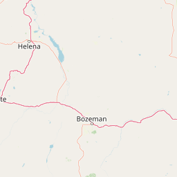
Lee Metcalf Wilderness Boundary Map and Geographic Extent
Mapped park boundaries provide visual spatial context for the protected landscape and its regional spread. Accompanying facts display calculated land area and coordinate spans without survey precision.
- Boundary area
- 988.1 km²
- Boundary perimeter
- 348.1 km
- Northernmost point
- 45.5817° N
- Southernmost point
- 44.8319° N
- Easternmost point
- 111.0968° W
- Westernmost point
- 111.645° W
- Geographic centre
- 45.1565° N, 111.4001° W
- North–south span
- 83.3 km
- East–west span
- 43.1 km
Terrain and natural features
Catalog of recorded mountain terrain features and streams
Lee Metcalf Wilderness Terrain and Named Natural Features Atlas
Mountain park classifications define the stored terrain profile alongside recorded peaks and streams. Linked feature cards document types and spatial relationships within the protected landscape.
Selected named natural features
Streams
Snowslide Creek
Peaks
Circle Mountain
2,575 m
Streams
Monument Creek
Streams
Jourdain Creek
Streams
South Fork Hell Roaring Creek
Environmental setting
Interpreting alpine climates, montane forests, and mountain relief profiles
Lee Metcalf Wilderness Environmental Classifications and Physical Geography
Recorded landscape features, habitat types, and seasonal classifications combine to frame the physical setting of Lee Metcalf Wilderness. Connected atlas destinations link these categories to broader regional geography.
- Relief
- Mountain
- Climate
- Alpine
- Water
- Minor water
- Forest cover
- Partial forest
- Seasonality
- Seasonal
Landscape features
Mountains · Valleys · Forest · Rivers
Habitat types
Montane forest · Alpine meadow
Park atlas
Discover surrounding mountain terrain and connected regional ecosystems
Explore Parks Near Lee Metcalf Wilderness and Related Protected Landscapes
Comparing parks near Lee Metcalf Wilderness reveals broader ecological patterns across the northern Rocky Mountains. Expanding the search connects individual alpine refuges to regional conservation networks and adjacent protected lands.
National parkWyoming
Park boundaries overlap#1 closest
Southeast

Yellowstone National Park: US National Park Protected Landscape & Geographic Atlas
Explore mapped boundaries and regional natural landscape context.
Yellowstone National Park represents a significant protected landscape within Wyoming, designated as a US national park. This entry offers detailed insight into its geographic scope, mapped boundaries, and the unique natural terrain that defines it. Understand its role in regional geography and discover its protected-area identity through a structured atlas exploration, providing context for its conservation landscape.
- Area
- 8,983.18 km²
- Established
- 1872
- IUCN
- II
- Visitors
- 4.7M annual
Nature reserveBeaverhead County
22 km away#2 closest
South
Red Rock Lakes Wilderness: Nature Reserve and Wetland Geography in Beaverhead County
High elevation marshes and protected water basins.
Red Rock Lakes Wilderness preserves an extensive high-elevation wetland complex in Beaverhead County, Montana. This nature reserve, characterized by shallow lake basins and forested mountain ridges, serves as a vital ecological corridor in the Northern Rockies. Its protected landscape offers a study in water-driven geography, where remote marshes and reflective lakes define the terrain's character.
- Area
- 130.9 km²
- Established
- 1976
- IUCN
- Ib
- Relief
- Upland

Protected landscapeMontana
66 km away#3 closest
North
Helena-Lewis and Clark National Forest: Geographic Overview and Protected Area Map
Montana wilderness spanning the Continental Divide
Spanning from the rolling eastern plains to the crest of the Northern Rockies, Helena-Lewis and Clark National Forest serves as a massive protected landscape in central Montana. This forest system protects eight unique mountain ranges and critical wilderness corridors, offering a comprehensive look at the ecological transition zones of the American Mountain West.
- Area
- 11,000 km²
- Established
- 1897
- Relief
- Mountain
- Climate
- Temperate

Protected landscapeWyoming
83 km away#4 closest
Southeast
Shoshone National Forest: A Comprehensive Map and Geography of America's Oldest National Forest
Rugged wilderness and glacial peaks in Wyoming
Discover the immense geographic scale of Shoshone National Forest, which protects a diverse landscape ranging from sagebrush valleys to 13,000-foot granite summits. This atlas overview details its role within the Greater Yellowstone Ecosystem and its expansive, federally designated wilderness areas, offering a clear perspective on its volcanic and glacial terrain.
- Area
- 9,992.69 km²
- Established
- 1891
- IUCN
- VI
- Visitors
- 500K annual
Wildlife reserveWyoming
87 km away#5 closest
South
Jedediah Smith Wilderness: Protected Alpine Terrain and Teton Range Geography
Glacially sculpted high-country basins in western Wyoming
Spanning the western face of the Teton Range, the Jedediah Smith Wilderness serves as a federally protected buffer for iconic mountain landscapes. The region features dramatic cirques, hanging valleys, and dense subalpine forest habitats, forming an essential, roadless link within the broader Greater Yellowstone Ecosystem. Explore the terrain features and structural geography that define this remote high-country wilderness area.
- Area
- 499.59 km²
- Established
- 1984
- IUCN
- Ib
- Relief
- Mountain
National parkUnited States of America
92 km away#6 closest
Southeast
Grand Teton National Park: Protected Landscape and Geographic Atlas Exploration
Explore the mapped terrain and regional park geography.
Grand Teton National Park is a protected landscape offering rich geographic discovery opportunities within the United States of America. This detailed entry facilitates an atlas-style exploration of its mapped boundaries, the surrounding regional geography, and its identity as a significant national park. Understand the specific landscape context and discover its placement within the broader natural terrain of North America.
- Area
- 1,300 km²
- Established
- 1929
- IUCN
- II
- Visitors
- 2.8M annual

Protected landscapeIdaho
124 km away#7 closest
West
Salmon, Challis National Forest: Geography and Protected Land Map in Central Idaho
Extensive alpine ridges and wild river corridors
Spanning over 4.2 million acres, Salmon, Challis National Forest is a foundational protected landscape in Idaho. This area includes the highest peaks in the state, such as Borah Peak, and holds the majority of the Frank Church, River of No Return Wilderness. Utilize this atlas resource to examine the intricate mountain topography, expansive river systems, and the contiguous wild corridors that define this significant portion of the northern Rockies.
- Area
- 17,142.2 km²
- Established
- 1908
- Relief
- Mountain
- Climate
- Temperate
Wildlife reserveMontana
139 km away#8 closest
North
Gates of the Mountains Wilderness: Montana Protected Landscape and Geographic Overview
Explore Missouri River canyon boundaries and local terrain
Gain insight into the geological drama of Gates of the Mountains Wilderness, a protected reserve in Montana. This atlas entry focuses on the limestone canyon walls and historic river corridors that define the regional geography, offering a structured look at its protected boundaries and terrain.
- Area
- 115.59 km²
- Established
- 1964
- IUCN
- Ib
- Relief
- Mountain
MoriAtlas Explorer
Continue Exploring the Lee Metcalf Wilderness Mountain Landscape and Geographic Data
Deepen your understanding of this significant Montana wilderness by reviewing its complex mountain units and protected boundaries. MoriAtlas provides a clear geographic context for these roadless alpine areas, highlighting their role in the greater Rocky Mountain ecosystem and large mammal conservation.
Browse next
Global natural geography
Explore related park routes
Explore MoriAtlas Global ParksBrowse All MoriAtlas ParksGlobal Park Map DiscoveryMoriAtlas: Browse All CountriesBrowse All MoriAtlas ContinentsNational Park Environment AtlasGrand Canyon National Park AtlasYellowstone National Park AtlasYosemite National Park Atlas and GeographySerengeti National Park AtlasGalápagos National Park Protected LandscapeBanff National Park Geography and AtlasKruger National Park Atlas EntryUluṟu-Kata Tjuṯa National Park AtlasExplore Uluru-Kata Tjuta National Park GeographyPlitvice Lakes National Park AtlasFiordland National Park Protected LandscapeGreat Smoky Mountains National Park AtlasAfghanistan National Parks and Protected AreasAlbania National Parks and Protected AreasAlgeria National Parks and Protected AreasAmerican Samoa National Parks and Protected AreasAndorra National Parks and Protected AreasAngola National Parks and Protected AreasAntarctica National Parks and Protected AreasAntigua and Barbuda Park List