Mori Atlas logo
Wildlife reserveLee Metcalf Wilderness

Mapping the fragmented alpine units, river canyons, and high subalpine valleys of this vital wilderness refuge

Lee Metcalf Wilderness: A Comprehensive Geographic Atlas of Montana Rocky Mountain Protected Landscapes

The Lee Metcalf Wilderness spans over 250,000 acres of rugged terrain across four distinct parcels in the northern Rocky Mountains of southwestern Montana. This protected area connects diverse landscapes including the steep Bear Trap Canyon, the high Spanish Peaks, the Taylor-Hilgard unit, and the Monument Mountains. Its status as a roadless, motor-free reserve preserves complex mountain topography and vital wildlife habitats that function as a critical corridor within the Greater Yellowstone Ecosystem.

wilderness areaalpine mountainsRocky Mountainssubalpine forestsriver canyonsgrizzly bear habitat

Lee Metcalf Wilderness

Wildlife reserve

Park overview

Structured park overview, official facts, and landscape profile for Lee Metcalf Wilderness

Lee Metcalf Wilderness park facts, protected area profile, and essential visitor context

Review the core facts for Lee Metcalf Wilderness, including designation, size, terrain, visitor scale, habitats, and operating context in one park-focused overview.

About Lee Metcalf Wilderness

The Lee Metcalf Wilderness is a mountainous federally designated wilderness area occupying a substantial portion of the northern Rocky Mountains in southwestern Montana. Spread across Madison and Gallatin counties and lying within reach of Bozeman, the wilderness covers a vast area of alpine ridges, forested valleys, river canyons, and high meadows.

Although often described as a single wilderness, Lee Metcalf is in fact a network of four separated land parcels. The Bear Trap Canyon unit focuses on canyonlands along the Madison River and is managed by the Bureau of Land Management. The Spanish Peaks, Taylor-Hilgard, and Monument Mountains units make up the larger forested alpine portion, jointly administered by the Beaverhead-Deerlodge and Gallatin National Forests under the U.S. Forest Service. This unusual multi-agency structure reflects the long history of different federal land ownership patterns in the region.

Ecologically, the wilderness sits at the heart of one of the most important natural landscapes in North America. The Gallatin National Forest portion falls within the Greater Yellowstone Ecosystem, and the wilderness directly borders Yellowstone National Park. Together with adjacent roadless areas, it forms a continuous block of high-quality habitat that supports the full suite of large mammals historically native to the region.

As a designated wilderness under the 1964 Wilderness Act, Lee Metcalf is governed by a strict set of protections: no roads, no buildings, no motorized or mechanized vehicles including bicycles, no logging, and no mining. Camping and fishing are allowed with proper permits, but the area is otherwise kept in a near-pristine state. This protected status is central to its identity and to its importance as a long-term refuge for wildlife, especially wide-ranging predators like grizzly bears and wolves.

Quick facts and research context for Lee Metcalf Wilderness

The Lee Metcalf Wilderness lies in Madison and Gallatin counties in southwestern Montana, with the nearest major city being Bozeman. It was established by Congress in 1983 as part of the National Wilderness Preservation System and is classified as an IUCN Category Ib protected area.

Roughly 254,000 acres in size, the wilderness is divided into four distinct units and managed jointly by the U.S. Forest Service (through the Beaverhead-Deerlodge and Gallatin National Forests) and the Bureau of Land Management. Its Gallatin Forest portion borders Yellowstone National Park and sits within the Greater Yellowstone Ecosystem.

The area is closed to motorized vehicles, bicycles, logging, mining, and permanent development, functioning as a roadless sanctuary whose primary significance lies in wildlife conservation and large landscape connectivity.

Protection and recognition

Examining documented terrestrial boundaries, management scope, and conservation status

Lee Metcalf Wilderness Protection Status and Recognition Records

Terrestrial protection status for Lee Metcalf Wilderness defines a distinct management scope within the regional landscape. Structured records outline baseline conservation designations and administrative boundary parameters without external recognition sources.

Protection details

Protection scope
Terrestrial
Transboundary protection
No
Park context

Deeper park guide and search-rich context for Lee Metcalf Wilderness

Lee Metcalf Wilderness history, landscape, wildlife, and travel context

Explore Lee Metcalf Wilderness through its history, landscape character, ecosystems, wildlife, conservation priorities, cultural context, and seasonal travel timing in a structured park guide built for atlas discovery and search intent.

Why Lee Metcalf Wilderness stands out

Lee Metcalf Wilderness is best known for its exceptionally high density of grizzly bears, the highest documented in the contiguous United States. This single wildlife statistic has shaped the area's reputation as a flagship refuge for threatened and endangered North American fauna. Beyond grizzlies, the wilderness is recognized for the remarkable completeness of its large mammal community, including wolves, wolverines, mountain goats, bighorn sheep, elk, moose, black bears, cougars, and Canada lynx. Its position adjacent to Yellowstone, combined with its roadless, undeveloped status, gives it outsized importance for wildlife movement, habitat connectivity, and intact predator-prey dynamics in the northern Rockies. The dramatic alpine scenery across its four separate units, from Bear Trap Canyon along the Madison River to the high peaks of the Spanish Peaks and Monument Mountains, adds a strong landscape identity to the area's wildlife-focused significance.
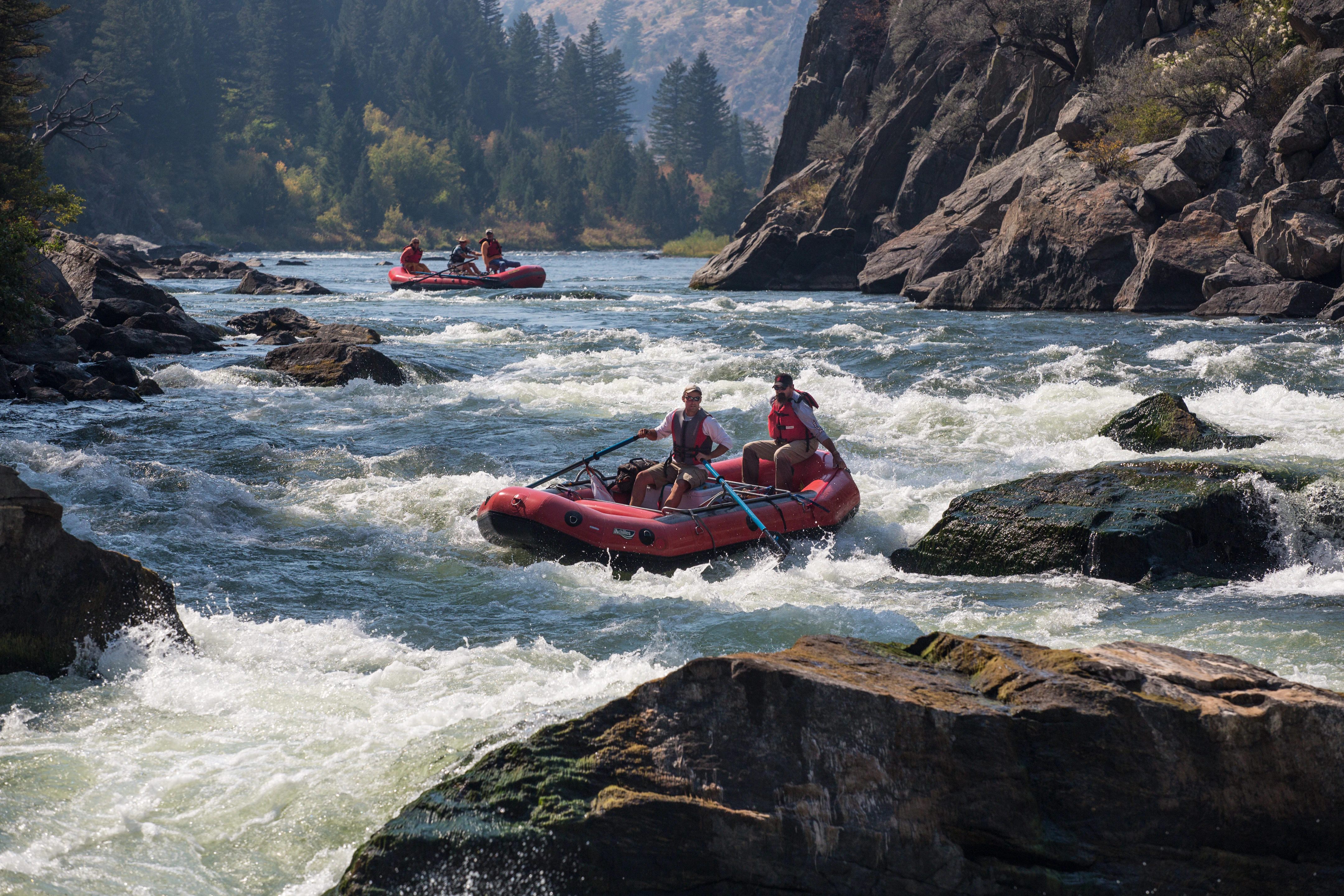
Two red inflatable rafts navigating whitewater rapids between rocky canyon walls.
Whitewater rafting through the rapids of Bear Trap Canyon in the Lee Metcalf Wilderness.

Lee Metcalf Wilderness history and protected-area timeline

The Lee Metcalf Wilderness was formally established in 1983 through an act of the United States Congress, becoming part of the National Wilderness Preservation System. Its designation reflected a growing national effort in the late twentieth century to protect large, roadless landscapes under the framework of the 1964 Wilderness Act.

The wilderness is composed of land parcels with distinct management histories. The Bear Trap Canyon unit traces its federal protection lineage to Bureau of Land Management holdings along the Madison River, while the Spanish Peaks, Taylor-Hilgard, and Monument Mountains units come from lands historically administered through the Beaverhead-Deerlodge and Gallatin National Forests. The consolidation of these separate parcels into one wilderness area in 1983 was a deliberate effort to recognize their combined ecological value.

The wilderness is named in honor of longtime Montana congressman Lee Metcalf, who was a notable advocate for conservation and public land protection during his career in the U.S. Senate and House of Representatives. Naming the area after him linked its protected status to a legacy of political support for Montana's wild landscapes.

Since its establishment, Lee Metcalf has grown in significance as conservation focus in the northern Rockies has shifted toward large mammal recovery, habitat connectivity, and buffering the Greater Yellowstone Ecosystem against development pressures. Its continued protection under the Wilderness Act has shaped its role as a long-term wildlife refuge.

Lee Metcalf Wilderness landscape and geographic character

The Lee Metcalf Wilderness occupies a rugged section of the northern Rocky Mountains characterized by complex alpine topography. Across its roughly 254,000 acres, the terrain shifts dramatically between glaciated mountain ridges, deep river-cut canyons, forested slopes, and open high-country meadows. Elevation varies enough to create a layered landscape of coniferous forests, subalpine parklands, and exposed alpine zones.

The Bear Trap Canyon unit, managed by the Bureau of Land Management, is defined by steep canyon walls and the corridor of the Madison River, giving this parcel a distinctly riverine and cliff-bound character. By contrast, the Spanish Peaks, Taylor-Hilgard, and Monument Mountains units are dominated by high peaks, ridgelines, and broad forested drainages typical of Montana's mountain wilderness.

Because the four units are geographically separated rather than continuous, the wilderness has a fragmented but varied landscape profile. Each unit contains its own assemblage of valleys, peaks, and watersheds, contributing to the overall ecological diversity of the protected area. The roadless condition of all four parcels preserves the visual and physical integrity of the terrain, allowing visitors to experience an unbroken mountain landscape largely free of modern infrastructure.

The area's subalpine climate, with long snowy winters and relatively short mild summers, shapes the seasonal rhythm of the landscape, influencing snowpack, runoff, and the timing of high-country access throughout the year.

Lee Metcalf Wilderness ecosystems, habitats, and plant life

The wilderness spans an elevation gradient that supports a layered mosaic of Rocky Mountain ecosystems. Lower slopes and river corridors carry mixed coniferous forest with lodgepole pine, Douglas fir, and spruces, while higher elevations transition into subalpine fir stands, krummholz, and open alpine tundra. The Bear Trap Canyon unit's Madison River corridor adds riparian and cliff habitat types that complement the higher forested and alpine zones of the other three units.

Wetland complexes, beaver-influenced streams, glacier-carved valleys, and wet mountain meadows provide rich habitat diversity across the wilderness. These varying conditions support a wide spectrum of plant communities, from dense evergreen forests to grassy high pastures and rocky fellfields. The result is a wilderness with substantial habitat heterogeneity despite its relatively narrow geographic range.

Because much of the land lies within or adjacent to the Greater Yellowstone Ecosystem, Lee Metcalf benefits from ecological processes typical of one of the largest mostly intact temperate ecosystems in the world. Fire, native ungulate grazing, and predator activity continue to shape vegetation patterns across the landscape in ways that are heavily altered or absent in more developed regions of North America.

Lee Metcalf Wilderness wildlife and species highlights

Lee Metcalf Wilderness is renowned for the exceptional density of grizzly bears within its boundaries, reportedly the highest in the contiguous United States. This makes the area one of the most important strongholds for grizzly recovery in the lower 48 states and a central node in ongoing conservation efforts for the species.

The wilderness supports a remarkably complete assemblage of North American large mammals. In addition to grizzlies, the area is home to gray wolves, wolverines, mountain lions (cougars), Canada lynx, black bears, elk, moose, mule deer, mountain goats, and bighorn sheep. This intact predator-prey community is a defining feature of the area and a major reason for its conservation significance.

Raptors and other large birds are also well represented. Bald eagles, ospreys, white pelicans, and trumpeter swans are noted among the area's birdlife, taking advantage of the rivers, lakes, and open habitats distributed across the wilderness. The combination of intact forest, alpine terrain, canyonlands, and riparian zones supports a diverse and ecologically meaningful wildlife community.

The roadless, undeveloped nature of Lee Metcalf is central to its wildlife value. Without motorized access, logging, or mining, the area offers large, secure habitat blocks in which sensitive species can den, forage, and move across the landscape with minimal human disturbance.

Lee Metcalf Wilderness conservation status and protection priorities

The Lee Metcalf Wilderness plays a disproportionate role in the conservation of large carnivores and other wide-ranging wildlife in the northern Rocky Mountains. Its protected status under the 1964 Wilderness Act provides a level of habitat security rarely matched elsewhere in the contiguous United States, with full prohibitions on motorized use, road building, logging, and mining.

The wilderness functions as a core refuge within the Greater Yellowstone Ecosystem, providing a buffer against habitat fragmentation in one of North America's most important remaining intact temperate landscapes. Its location adjacent to Yellowstone National Park strengthens connectivity for species that require large, unbroken territories, including grizzly bears, wolves, and wolverines.

Lee Metcalf is often highlighted in discussions of grizzly bear conservation because of the high density of bears within its boundaries. Maintaining this population depends on the wilderness's continued roadless and low-disturbance character, which limits human-wildlife conflict and preserves crucial foraging and denning habitat.

Beyond carnivores, the area contributes to the long-term viability of mountain goat, bighorn sheep, elk, moose, and rare bird populations, all of which benefit from the ecological integrity that wilderness designation confers. The area stands as a working example of large-landscape conservation in the American West.

Lee Metcalf Wilderness cultural meaning and human context

The landscape surrounding the Lee Metcalf Wilderness carries a deep human history tied to ranching, mining-era settlement, and traditional use of Montana's mountain valleys. Although the wilderness itself is intentionally kept undeveloped, the broader region reflects a long interplay between resource-based economies and the gradual movement toward preservation that culminated in the 1983 wilderness designation.

Montana's identity as a state with strong connections to its wild public lands is part of the cultural backdrop of the area. Naming the wilderness after Montana congressman Lee Metcalf, a politician recognized for his work on environmental and public land issues, ties the protected landscape to a political and cultural legacy of conservation advocacy in the state.

For residents of nearby communities such as Bozeman and Ennis, the wilderness is woven into everyday life as a place of recreation, hunting, fishing, and traditional outdoor pursuits that continue to shape regional identity in southwestern Montana.

Top sights and standout views in Lee Metcalf Wilderness

The Lee Metcalf Wilderness stands out for combining exceptionally intact wildlife habitat with a dramatic and varied alpine landscape. Its four separate units, from the Madison River canyonlands of Bear Trap Canyon to the high peaks of the Spanish Peaks and Monument Mountains, give the wilderness a layered geographic identity.

Its position within the Greater Yellowstone Ecosystem and directly adjacent to Yellowstone National Park places it at the heart of one of the most ecologically important regions in North America, particularly for large carnivores. The wilderness is frequently highlighted as a flagship example of how Wilderness Act protections translate into real outcomes for grizzly bear and wolf conservation.

For visitors and researchers alike, Lee Metcalf offers the rare combination of a roadless, motor-free landscape, high scenic value, and direct connections to one of the world's best-known intact temperate ecosystems.

Best time to visit Lee Metcalf Wilderness

The Lee Metcalf Wilderness experiences a subalpine climate with long, snowy winters and short, comparatively mild summers. Snowpack lingers well into spring at higher elevations, and high-country trails are typically accessible only from late spring or early summer onward once conditions allow safe travel.

Summer and early autumn are generally the most practical windows for non-winter recreation, when alpine meadows are accessible, rivers and creeks run clear, and wildlife viewing opportunities extend across the range of elevations. Fall can offer quieter conditions and the chance to see rutting elk and other seasonal wildlife behaviors in the high country.

Winter brings deep snow, extreme cold, and increased avalanche risk in steep terrain, making travel slow and demanding for those equipped and experienced for it. Visitors should plan around the short favorable season for casual or moderate outdoor use, while recognizing that winter brings its own challenges and rewards for properly prepared travelers.

Monthly climate preview

Track representative annual temperature swings and monthly precipitation patterns across Montana terrain

Lee Metcalf Wilderness Climate Normals and Long-Term Weather by Month

Representative coordinate records show sustained sub-zero winter temperatures giving way to milder summer maximums alongside consistent monthly precipitation rates. Detailed long-term climate normals reveal the complete twelve-month cycle of temperature averages and precipitation metrics for Lee Metcalf Wilderness.
Annual mean0 °C
-12 °C15 °C
Jan-12°
Feb-11°
Mar-7°
Apr-2°
May
Jun10°
Jul15°
Aug14°
Sep
Oct
Nov-7°
Dec-12°
Warmest month
July

15.1 °C

Coolest month
December

-12 °C

Wettest month
May

2.7 mm/day

Driest month
August

1.2 mm/day

Park location guide

Geography guide, regional context, and park location map for Lee Metcalf Wilderness

Lee Metcalf Wilderness park geography, regions, and map view in United States of America

Understand where Lee Metcalf Wilderness sits in United States of America through a broader geographic reading of the surrounding landscape, nearby location context, and its mapped position within the national park landscape.

How Lee Metcalf Wilderness fits into United States of America

The United States of America is a federal presidential republic and one of the world's largest countries by area and population. It consists of 50 states across a vast territory spanning multiple time zones, with its capital in Washington, D.C. and largest city in New York City. The nation has a diverse economy, influential political system, and significant cultural and military presence globally.

Wider geography shaping Lee Metcalf Wilderness in United States of America

The United States occupies a vast territory in North America, bordered by Canada to the north and Mexico to the south. The 48 contiguous states stretch from the Atlantic to the Pacific Ocean, while Alaska occupies the northwestern region and Hawaii is an archipelago in the Pacific. The country encompasses diverse terrain including the Rocky Mountains, Appalachian Mountains, Great Plains, and extensive river systems.

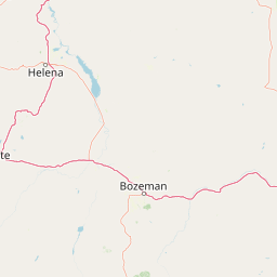
Map view of Lee Metcalf Wilderness

Use this park location map to pinpoint Lee Metcalf Wilderness in United States of America, understand its exact geographic position, and read its mapped placement within the surrounding landscape more clearly.

Pigeon | © OpenStreetMap contributors

Location context for Lee Metcalf Wilderness

Montana
Natural feature types

Explore the Geographic Features and Alpine Landscapes of Lee Metcalf Wilderness

Navigate the complex topography of the Lee Metcalf Wilderness through our structured atlas of identified natural features. This collection serves as a regional map and data resource for examining the varied peaks, river corridors, and subalpine habitats that define these four distinct, protected mountain units.
Recorded earthquake history

Explore Historical Earthquake Records Associated with Lee Metcalf Wilderness

Examine the recorded seismic history surrounding the Lee Metcalf Wilderness through a structured collection of historical earthquake data. This MoriAtlas resource maps regional seismic activity, allowing for a clearer understanding of local geological history in the northern Rocky Mountains.

Lee Metcalf Wilderness Earthquake History

Catalogued events

435 events

Strongest magnitude

Magnitude 5.9

Most recent event

Nov 10, 2025

This history includes earthquakes recorded inside the park or within 50 km of its borders

Explore protected area views, alpine ridges, and river canyon habitats across four distinct parcels.

Lee Metcalf Wilderness Photos and Landscape Scenery: Visualizing Montana Mountain Terrain

Visual documentation captures the rugged alpine topography, glaciated mountain ridges, and deep river canyons defining the four protected units of Lee Metcalf Wilderness. Examining national park photography reveals the intact wildlife habitats and undeveloped terrain characterizing this northern Rocky Mountain refuge.

Two red inflatable rafts navigating whitewater rapids between rocky canyon walls.

Park atlas

Discover surrounding mountain terrain and connected regional ecosystems

Explore Parks Near Lee Metcalf Wilderness and Related Protected Landscapes

Comparing parks near Lee Metcalf Wilderness reveals broader ecological patterns across the northern Rocky Mountains. Expanding the search connects individual alpine refuges to regional conservation networks and adjacent protected lands.
National parkWyoming
Park boundaries overlap#1 closest

Southeast

Yellowstone National Park: US National Park Protected Landscape & Geographic Atlas

Explore mapped boundaries and regional natural landscape context.

Yellowstone National Park represents a significant protected landscape within Wyoming, designated as a US national park. This entry offers detailed insight into its geographic scope, mapped boundaries, and the unique natural terrain that defines it. Understand its role in regional geography and discover its protected-area identity through a structured atlas exploration, providing context for its conservation landscape.

Area
8,983.18 km²
Established
1872
IUCN
II
Visitors
4.7M annual
Nature reserveBeaverhead County
22 km away#2 closest

South

Red Rock Lakes Wilderness: Nature Reserve and Wetland Geography in Beaverhead County

High elevation marshes and protected water basins.

Red Rock Lakes Wilderness preserves an extensive high-elevation wetland complex in Beaverhead County, Montana. This nature reserve, characterized by shallow lake basins and forested mountain ridges, serves as a vital ecological corridor in the Northern Rockies. Its protected landscape offers a study in water-driven geography, where remote marshes and reflective lakes define the terrain's character.

Area
130.9 km²
Established
1976
IUCN
Ib
Relief
Upland
A watercolor painting depicting a soft, stylized mountain range and a river winding through a valley.
Protected landscapeMontana
66 km away#3 closest

North

Helena-Lewis and Clark National Forest: Geographic Overview and Protected Area Map

Montana wilderness spanning the Continental Divide

Spanning from the rolling eastern plains to the crest of the Northern Rockies, Helena-Lewis and Clark National Forest serves as a massive protected landscape in central Montana. This forest system protects eight unique mountain ranges and critical wilderness corridors, offering a comprehensive look at the ecological transition zones of the American Mountain West.

Area
11,000 km²
Established
1897
Relief
Mountain
Climate
Temperate
Watercolor painting of a peaceful mountain valley landscape, showing a small winding stream in the foreground, grassy meadows, clusters of pine trees, and rolling mountain peaks in a soft, sunset-colored sky.
Protected landscapeWyoming
83 km away#4 closest

Southeast

Shoshone National Forest: A Comprehensive Map and Geography of America's Oldest National Forest

Rugged wilderness and glacial peaks in Wyoming

Discover the immense geographic scale of Shoshone National Forest, which protects a diverse landscape ranging from sagebrush valleys to 13,000-foot granite summits. This atlas overview details its role within the Greater Yellowstone Ecosystem and its expansive, federally designated wilderness areas, offering a clear perspective on its volcanic and glacial terrain.

Area
9,992.69 km²
Established
1891
IUCN
VI
Visitors
500K annual
Wildlife reserveWyoming
87 km away#5 closest

South

Jedediah Smith Wilderness: Protected Alpine Terrain and Teton Range Geography

Glacially sculpted high-country basins in western Wyoming

Spanning the western face of the Teton Range, the Jedediah Smith Wilderness serves as a federally protected buffer for iconic mountain landscapes. The region features dramatic cirques, hanging valleys, and dense subalpine forest habitats, forming an essential, roadless link within the broader Greater Yellowstone Ecosystem. Explore the terrain features and structural geography that define this remote high-country wilderness area.

Area
499.59 km²
Established
1984
IUCN
Ib
Relief
Mountain
National parkUnited States of America
92 km away#6 closest

Southeast

Grand Teton National Park: Protected Landscape and Geographic Atlas Exploration

Explore the mapped terrain and regional park geography.

Grand Teton National Park is a protected landscape offering rich geographic discovery opportunities within the United States of America. This detailed entry facilitates an atlas-style exploration of its mapped boundaries, the surrounding regional geography, and its identity as a significant national park. Understand the specific landscape context and discover its placement within the broader natural terrain of North America.

Area
1,300 km²
Established
1929
IUCN
II
Visitors
2.8M annual
Soft watercolor illustration of a rolling mountain landscape with a forested foreground and faded, distant peaks.
Protected landscapeIdaho
124 km away#7 closest

West

Salmon, Challis National Forest: Geography and Protected Land Map in Central Idaho

Extensive alpine ridges and wild river corridors

Spanning over 4.2 million acres, Salmon, Challis National Forest is a foundational protected landscape in Idaho. This area includes the highest peaks in the state, such as Borah Peak, and holds the majority of the Frank Church, River of No Return Wilderness. Utilize this atlas resource to examine the intricate mountain topography, expansive river systems, and the contiguous wild corridors that define this significant portion of the northern Rockies.

Area
17,142.2 km²
Established
1908
Relief
Mountain
Climate
Temperate
Watercolor painting of a light-colored landscape featuring a river meandering through green trees and soft hills against a hazy background.
Wildlife reserveMontana
139 km away#8 closest

North

Gates of the Mountains Wilderness: Montana Protected Landscape and Geographic Overview

Explore Missouri River canyon boundaries and local terrain

Gain insight into the geological drama of Gates of the Mountains Wilderness, a protected reserve in Montana. This atlas entry focuses on the limestone canyon walls and historic river corridors that define the regional geography, offering a structured look at its protected boundaries and terrain.

Area
115.59 km²
Established
1964
IUCN
Ib
Relief
Mountain

Common questions about visiting, size, designation, and location context for Lee Metcalf Wilderness

Lee Metcalf Wilderness FAQs for park facts, access, geography, and protected area context

Find quick answers about Lee Metcalf Wilderness, including protected-area facts, park geography, trail and visitor context, and how the park fits into its surrounding country and regional landscape.
MoriAtlas Explorer

Continue Your Protected Areas Search Across the Global Atlas

Deepen your exploration by continuing the structured search for national parks and protected areas worldwide. Utilize the comprehensive filtering capabilities to compare different conservation landscapes and refine your understanding of global park geography. Discover more about the distribution and characteristics of protected natural areas.

Global natural geography