
Viewpoints
Park geography
A technical overview of mapped park boundaries, landscape habitat types, and internal landmarks.
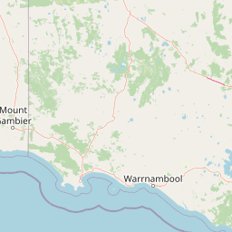
Little Desert National Park Geographic Profile, Boundary Dimensions, and Natural Land Features
The geography of Little Desert National Park encompasses 1326.47 square kilometers of protected landscape in Australia. This profile details the park spatial extent, featuring recorded internal points such as the Wimmera River, Mount Moffat, and various local lookouts. Analysis of the boundary data reveals a lowland relief characterized by diverse mediterranean forest, shrubland, and wetland habitats within an arid climatic context.
Related tags
semi-arid wildernessmallee heathlandImportant Bird Areafour-wheel-drive tracksVictoria national parks
Victoria's mallee wilderness with ancient sand dunes and unique desert ecosystems
Little Desert National Park
Little Desert National Park is a vast protected area in northwestern Victoria, Australia, encompassing approximately 1,326 square kilometres of semi-arid wilderness. The park is situated near the town of Dimboola, roughly 375 kilometres west of Melbourne, and stretches from the Wimmera River in the east to the South Australian border in the west. Unlike a true desert, this region features sandy soils supporting distinctive mallee heathland and woodland ecosystems that have remained relatively undisturbed by human activity. The park is divided into three distinct blocks—Western, Central, and Eastern—each offering different ecological characteristics and recreational opportunities. The area represents one of Victoria's most significant conservation reserves, protecting a fragile desert landscape that supports remarkable biodiversity including over 200 bird species and populations of threatened malleefowl.
- Location
- Australia
- Park type
- National park
- Established
- 1988
- Area
- 1,326.5 km²
Location overview
Terrestrial boundary profile and national administrative location
Geographic Setting of Little Desert National Park in Australia
Little Desert National Park is positioned entirely within the continental borders of Australia. As a non-coastal inland reserve, its administrative placement reflects a fully terrestrial, non-transboundary designation.
- Countries
- Australia
- Primary location
- Australia
- Geographic setting
- Inland
Boundary and coordinates
A 1,326.47 km² outline with geographic context
Little Desert National Park mapped boundary and area
Little Desert National Park’s mapped footprint spans a recorded 1,326.47 km². It conveys the park’s substantial geographic reach for atlas discovery while remaining distinct from survey-authoritative geometry.
- Boundary area
- 1,316.3 km²
- Boundary perimeter
- 407.9 km
- Northernmost point
- 36.42° S
- Southernmost point
- 36.6683° S
- Easternmost point
- 142.0304° E
- Westernmost point
- 140.968° E
- Geographic centre
- 36.5572° S, 141.4913° E
- North–south span
- 27.6 km
- East–west span
- 95.1 km
Terrain and natural features
Stored lowland classifications and recorded geographic features
Little Desert National Park Terrain and Named Natural Features
Lowland terrain classifications define the protected landscape alongside recorded named features located within the park boundary. Linked feature cards supply official types, measurements, and spatial relationships for each entity.
Selected named natural features
Viewpoints
Sister Hills Lookout
Lakes
Salt Lake
Viewpoints
Wimmera River
Reservoirs
Mount Moffat Fire Dam
Rivers
Wimmera River
Environmental setting
Arid lowland terrain, partial forest cover, and seasonal waterways
Little Desert National Park Environmental Setting and Habitat Classification
Stored landscape features, habitat types, and climatic zones function as complementary ways to read the physical setting of Little Desert National Park. Recorded categories connect directly to relevant atlas destinations where available for broader regional exploration.
- Relief
- Lowland
- Climate
- Arid
- Water
- Minor water
- Forest cover
- Partial forest
- Seasonality
- Seasonal
Landscape features
Woodland · Grassland · Wetland
Habitat types
Mediterranean forest · Heath · Shrubland · Wetland
Park atlas
Explore regional protected landscapes and compare mapped park geography across Victoria's semi-arid wilderness.
Discover Other National Parks and Protected Areas Near Little Desert National Park
Continue your atlas journey from Little Desert National Park by exploring other national parks and protected areas within Victoria, focusing on similar mallee heathland and semi-arid wilderness regions. Compare diverse conservation landscapes, trace the regional spread of protected areas, and expand your geographic understanding of Australia's significant natural reserves.
Wildlife reserveSouth Australia
About 4.6 km away#1 closest
Northwest

Custon Conservation Park: Protected Wildlife Reserve and Woodland Landscape in South Australia
Geographic atlas of protected native grassy woodlands and local biodiversity reserves
Custon Conservation Park represents a vital protected land parcel within South Australia, focused on the conservation of endangered Grey-box Grassy Woodland. The site acts as a specialized wildlife reserve where native vegetation associations are preserved through integrated ecological strategies. This detail page offers insight into the park boundaries and regional environmental context of this significant Limestone Coast protected area.
- Area
- 0.64 km²
- Established
- 2007
- IUCN
- III
- Relief
- Lowland
Nature reserveSouth Australia
About 10 km away#2 closest
West
Geegeela Conservation Park: Mapped Geography and Protected Area Data
Ecological restoration and woodland habitat in South Australia
Geegeela Conservation Park stands as a significant nature reserve within the Limestone Coast of South Australia. Covering over eight square kilometres, this area protects a regenerating mosaic of desert banksia heath and stringybark woodland, offering a critical refuge for local bird species and nationally endangered fauna within the surrounding rural landscape.
- Area
- 8.58 km²
- Established
- 2005
- IUCN
- III
- Relief
- Lowland
Nature reserveSouth Australia
About 29 km away#3 closest
Southwest
Grass Tree Conservation Park: A Protected Nature Reserve in South Australia
Geography and native woodland map exploration.
Grass Tree Conservation Park is a 16 hectare nature reserve in the Limestone Coast of South Australia, focused on the protection of iconic grass trees. The reserve captures a landscape of calcarenite dunes and diverse forest communities, including brown stringybark and pink gum. Through its protected status, it offers valuable insight into the native vegetation and sandy terrain typical of the West Naracoorte Range.
- Area
- 0.16 km²
- Established
- 1972
- IUCN
- III
- Relief
- Lowland
National parkSouth Australia
42 km away#4 closest
Southwest
Naracoorte Caves National Park: Detailed Map and Protected Landscape Context in South Australia
Explore its unique protected geography and natural terrain.
Naracoorte Caves National Park represents a vital protected area within the diverse geography of South Australia. This entry provides an atlas-driven perspective, highlighting its identity as a national park, its mapped landscapes, and its regional significance. Engage with structured information detailing the park's protected status and geographic features, offering a clear view of its contribution to South Australia's natural heritage.
- Area
- 6.6 km²
- Established
- 2001
- IUCN
- II
- Visitors
- 90.8K annual
National parkAustralia
47 km away#5 closest
Southeast
Grampians National Park National Park: Sandstone Ranges and Aboriginal Heritage Atlas
Explore its mapped protected landscape and regional geography.
Grampians National Park stands as a testament to Victoria's natural and cultural heritage, featuring striking sandstone mountain ranges and an exceptional concentration of Aboriginal rock art sites. This protected area offers a deep dive into the region's unique geology, from its ancient sedimentary rock formations to its dramatic cliff faces and peaks. Understanding the park's mapped boundaries and its place within the broader geography provides essential context for appreciating its protected landscape identity and its millennia-long human history.
- Area
- 1,672.19 km²
- Established
- 1984
- IUCN
- II
- Relief
- Mountain
Nature reserveSouth Australia
50 km away#6 closest
West
Fairview Conservation Park: Protected Nature Reserve and Limestone Coast Geography
Mapped wetlands, sandy ridges, and woodlands in southeastern South Australia
Explore the geographic framework of Fairview Conservation Park, a nature reserve in South Australia's Limestone Coast. The protected area features a unique intersection of semi-permanent lagoons, periodically inundated flats, and varied woodland vegetation including blue gum and manna gum, offering a clear window into the regional geological and ecological character of the area.
- Area
- 13.94 km²
- Established
- 1960
- IUCN
- Ia
- Relief
- Lowland
Nature reserveSouth Australia
52 km away#7 closest
Southwest
Hacks Lagoon Conservation Park: Wetland Landscape and Protected Area Geography
A vital Ramsar wetland site in the South Australia Limestone Coast region
Hacks Lagoon Conservation Park provides a protected freshwater sanctuary amidst the rural plains of South Australia. This nature reserve sustains a diverse wetland habitat, encompassing open water, marshes, and seasonally flooded zones that support critical waterbird populations within an internationally recognized ecological system.
- Area
- 2.02 km²
- Established
- 1967
- IUCN
- IV
- Relief
- Lowland
National parkAustralia
54 km away#8 closest
Northeast
Wyperfeld National Park: Mapping Victoria's Vast Mallee Semi-Arid Wilderness and Sandhill Landscapes
Discover the unique geography and protected terrain of this significant Australian national park.
Wyperfeld National Park in Victoria, Australia, is a prime example of a vast semi-arid wilderness landscape. It is best known for its extensive sandhill formations, referred to as 'snowdrifts,' which punctuate the otherwise flat terrain. The park also protects a significant ephemeral lake system and is a stronghold for the mallee ecosystem, offering a unique context for understanding dryland conservation and mapped natural areas. Its protected status highlights its importance within the broader geographic context of Australia's protected landscapes.
- Area
- 3,570 km²
- Established
- 1921
- IUCN
- II
- Relief
- Lowland
MoriAtlas Explorer
Continue Exploring Little Desert National Park's Geographic and Landscape Context
To further understand the significance of Little Desert National Park within Australia's protected areas network, examine its detailed geographic features and mapped boundaries. This national park offers a unique case study in semi-arid ecosystem conservation and regional landscape identity, providing rich context for atlas-based discovery. Investigate its specific terrain characteristics and its place in the broader geographic narrative of Victoria's natural heritage.
Browse next
Global natural geography
Explore related park routes
Explore MoriAtlas Global ParksBrowse All MoriAtlas ParksGlobal Park Map DiscoveryMoriAtlas: Browse All CountriesBrowse All MoriAtlas ContinentsNational Park Environment AtlasGrand Canyon National Park AtlasYellowstone National Park AtlasYosemite National Park Atlas and GeographySerengeti National Park AtlasGalápagos National Park Protected LandscapeBanff National Park Geography and AtlasKruger National Park Atlas EntryUluṟu-Kata Tjuṯa National Park AtlasExplore Uluru-Kata Tjuta National Park GeographyPlitvice Lakes National Park AtlasFiordland National Park Protected LandscapeGreat Smoky Mountains National Park AtlasAfghanistan National Parks and Protected AreasAlbania National Parks and Protected AreasAlgeria National Parks and Protected AreasAmerican Samoa National Parks and Protected AreasAndorra National Parks and Protected AreasAngola National Parks and Protected AreasAntarctica National Parks and Protected AreasAntigua and Barbuda Park List