

Mori Atlas logo
National parkLos Remedios National Park

Discover the mapped terrain, geological features, and cultural boundaries of this significant national park.

Los Remedios National Park: Protected Area and Historical Landscape in Mexico State

Los Remedios National Park represents a unique protected landscape in Mexico State, centered on the historically rich Cerro Moctezuma. Established as a national park, it preserves a vital intersection of pre-Hispanic astronomical observatories, colonial engineering marvels like its iconic aqueduct, and significant post-conquest narratives. This page offers an atlas-style exploration of its mountainous terrain, geological context, and mapped boundaries, providing essential geographic context for this culturally dense protected area.

National ParkMexicoArchaeological SiteColonial ArchitectureHistorical HeritageProtected Area

Los Remedios National Park

National park

Park overview

Structured park overview, official facts, and landscape profile for Los Remedios National Park

Los Remedios National Park park facts, protected area profile, and essential visitor context

Review the core facts for Los Remedios National Park, including designation, size, terrain, visitor scale, habitats, and operating context in one park-focused overview.

About Los Remedios National Park

Los Remedios National Park occupies a distinctive position among Mexico's protected areas as a site where natural landscape, colonial architecture, and pre-Hispanic archaeological remains coexist within a mountainous setting immediately adjacent to one of the world's largest metropolitan areas. The park is located in the municipality of Naucalpan in Mexico State, approximately 400 meters above the Valley of Mexico floor, making it a prominent green space within the western edge of the Mexico City metropolitan region. The geological foundation consists primarily of clastic and volcanic rocks, with soils characterized by a dark, nutrient-rich surface layer. The park's establishment in 1938 reflected early 20th-century Mexican efforts to preserve significant natural and cultural landscapes, though the original declared area appears to have been larger than the current official 400 hectares. The mountain of Cerro Moctezuma serves as the park's central geographic and historical feature, providing both the archaeological significance and the elevated terrain that distinguishes this protected area from surrounding urban development. The interplay between the colonial aqueduct's monumental arches, the religious sanctuary, and the pre-Hispanic archaeological zone creates a cultural landscape of unusual density, while the surrounding vegetation and wildlife populations represent remnant ecological communities within an intensely urbanized region.

Quick facts and research context for Los Remedios National Park

Los Remedios National Park covers 400 hectares in Naucalpan, Mexico State, established in 1938. The park sits at roughly 2300 meters elevation on Cerro Moctezuma, featuring semi-dry steppe climate with average temperatures of 18°C and annual precipitation between 600 and 800 millimeters. Within its boundaries lie the Sanctuary of the Virgin of Los Remedios, a 500-meter colonial aqueduct with fifty arches standing 16 meters high, and a pre-Hispanic archaeological zone. The park contains more than 160 plant and animal species, with four species listed under Mexico's threatened species category NOM-059. The area holds significant historical importance as both an Aztec observatory and the reputed resting place of Hernán Cortés after the fall of Tenochtitlan.

Protection and recognition

Tracking the official terrestrial boundary records and conservation data

Los Remedios National Park Protection Status and Designation Framework

Official records verify the terrestrial designation parameters and administrative framework established for Los Remedios National Park. Evaluating verified parameters provides geographers with essential context regarding the historical status and conservation scope of the protected landscape.

Protection details

Protection scope
Terrestrial
Transboundary protection
No
Park context

Deeper park guide and search-rich context for Los Remedios National Park

Los Remedios National Park history, landscape, wildlife, and travel context

Explore Los Remedios National Park through its history, landscape character, ecosystems, wildlife, conservation priorities, cultural context, and seasonal travel timing in a structured park guide built for atlas discovery and search intent.

Why Los Remedios National Park stands out

Los Remedios National Park is most notably recognized for its extraordinary concentration of historical and cultural features within a relatively small protected area. The park preserves a 17th-century colonial aqueduct spanning 500 meters with fifty arches, flanking the Sanctuary of the Virgin of Los Remedies. This architectural monument, constructed in two phases between 1616 and 1765, represents significant colonial engineering achievement. Equally significant is the pre-Hispanic archaeological component, with evidence of a Chichimeca temple and confirmed use as an Aztec astronomical observatory on Cerro Moctezuma. The park's location on the same mountain where Cortés is believed to have paused after fleeing the Aztec capital creates a unique intersection of pre-Hispanic, colonial, and post-conquest historical narratives.

Los Remedios National Park history and protected-area timeline

Los Remedios National Park was established by federal decree on April 15, 1938, during a period when Mexico was systematically designating protected areas to preserve significant natural and cultural landscapes. The park's creation reflected recognition of the area's multiple historical layers and its importance as a green space serving the metropolitan region. The colonial infrastructure within the park, particularly the aqueduct, represents a significant construction history. The first phase of the aqueduct was built in 1616 under Viceroy Diego Fernández de Córdoba, Marquis of Guadalcázar, designed to transport water from a spring at San Francisco Chimalpa to the Sanctuary of Los Remedios. This water supply also served agricultural irrigation needs in the surrounding villages of San Bartolomé, Santa María Nativitas, and Santa Cruz. The original system consisted primarily of clay pipes with two spiral air-release towers, known locally as "caracoles" or snails, which flank the sanctuary. By 1764, the water supply proved insufficient, leading Viceroy Joaquín de Montserrat to commission the arched aqueduct system completed in 1765. Eventually, this system also failed to provide adequate water and became primarily an architectural monument. The park's historical significance extends further back to the pre-Hispanic period, when the site functioned as an Aztec astronomical observatory on Cerro Moctezuma, and is believed to be the location where Hernán Cortés and his forces rested during their retreat from Tenochtitlan following the 1521 conquest.

Los Remedios National Park landscape and geographic character

The physical landscape of Los Remedios National Park is defined by its mountainous terrain centered on Cerro Moctezuma, which rises prominently above the surrounding Valley of Mexico at approximately 2300 meters above sea level. The geological foundation consists predominantly of clastic and volcanic rocks, reflecting the region's tectonic and igneous heritage. Soils are characterized by a dark, soft surface layer that is rich in organic matter and nutrients, classified within the edaphological system as H-type soils. The terrain creates a distinctive topography within the western edge of the Mexico City metropolitan area, providing both visual prominence and ecological separation from surrounding urban development. The park's elevation and rocky substrate contrast with the valley floor below, creating a landscape of considerable topographic relief. The colonial aqueduct follows the terrain contour, its fifty arches creating a linear monumental element that integrates with the natural topography while serving as a defining cultural landscape feature. The surrounding area, despite heavy urbanization pressures, retains elements of the original landform character within the protected boundary.

Los Remedios National Park ecosystems, habitats, and plant life

The ecological character of Los Remedios National Park reflects its position within the Valley of Mexico's transition zone, characterized by semi-dry steppe climate conditions with summer rainfall patterns. Average annual temperature is approximately 18°C with precipitation ranging between 600 and 800 millimeters annually. Despite the park's small size and extreme urban pressures, biodiversity surveys have documented more than 160 plant and animal species within its boundaries, including four species recognized under Mexico's NOM-059 threatened species category. The vegetation community includes a mix of introduced and native species, with eucalyptus, white cedar, pine, and ash among the predominant tree species, along with capulín and areas of grassland. The presence of numerous exotic species, totaling 33 documented in the park, reflects both historical planting decisions and ongoing colonization by non-native plants. The park represents a remnant of the ecological communities that once covered larger areas of the Valley of Mexico's western slopes, with its biodiversity value enhanced by the contrast with surrounding urbanized landscape.

Los Remedios National Park wildlife and species highlights

The wildlife community within Los Remedios National Park, while limited by the park's small size and disturbed condition, includes several species adapted to the semi-urban environment. Mammalian species present include the cacomixtle, a type of opossum common in central Mexican landscapes, and the red-bellied squirrel. Bird diversity is more notable, with species including the long-tailed dove, several hummingbird species such as the berillo hummingbird and broad-billed hummingbird, the cardinal flycatcher, the spring robin, various tyrant flycatcher species, the butcherbird, the Mexican oropendola, and the Mexican woodpecker. Reptile diversity includes terrestrial snakes, the collared spiny lizard, and mountain alligator lizards. Amphibian species include canyon frogs. The presence of 33 exotic species, including the Argentine monk parakeet, house sparrow, and various introduced snails and plants, indicates significant ecological disturbance, though the remaining native species and habitat elements continue to support wildlife populations within this urban-proximate protected area.

Los Remedios National Park conservation status and protection priorities

Los Remedios National Park faces severe and ongoing conservation challenges that have dramatically reduced its effective protected area. Of the original declared forest area, which appears to have been approximately 410 hectares, less than 100 hectares of natural habitat remain today. Approximately 75 percent of the park's surface area now contains illegal settlements, including some authorized by local authorities despite federal law prohibiting such encroachment on protected lands. The park lacks a formal conservation and management program, protective fencing, and other mechanisms to resist development pressure. Environmental enforcement has been limited, with federal environmental agency Profepa responding to complaints about tree removal and development proposals only through inspections rather than effective protection. The illegal settlements and new construction have extended onto adjacent ejido lands and are beginning to encroach on the archaeological zone, prompting involvement from the National Institute of Anthropology and History (INAH) and community organizing among neighboring residents. The conversion of original forest to urban land uses, combined with the filling of ravines and watersheds with construction debris, represents a significant conservation failure that has diminished both the ecological and cultural values this national park was created to protect.

Los Remedios National Park cultural meaning and human context

The cultural context of Los Remedios National Park is exceptionally rich, encompassing multiple historical periods within a relatively compact area. The pre-Hispanic period is represented by archaeological evidence of a Chichimeca temple and the confirmed use of Cerro Moctezuma as an Aztec astronomical observatory, indicating the site's importance in pre-Columbian religious and scientific practices. Following the Spanish conquest, the site acquired new religious significance through the Sanctuary of the Virgin of Los Remedios, which became a destination for pilgrimages and remains an active religious site. The colonial period left the aqueduct, constructed in two phases between 1616 and 1765, as both a functional water supply system and an architectural landmark. The site also holds post-conquest historical significance as the reputed location where Hernán Cortés and his forces rested during their retreat from Tenochtitlan in 1521 after the fall of the Aztec capital. This layering of Chichimeca, Aztec, colonial, and post-conquest historical narratives within a single protected area creates cultural context of unusual depth and complexity.

Top sights and standout views in Los Remedios National Park

Los Remedios National Park stands out for the extraordinary density of significant cultural features within its boundaries, combining pre-colonial archaeological evidence, colonial-era religious architecture, and one of the region's most impressive colonial engineering structures. The 500-meter aqueduct with its fifty arches reaching 16 meters in height represents a remarkable architectural achievement, while the Sanctuary of the Virgin of Los Remedies continues to function as an active religious site. The archaeological zone on Cerro Moctezuma preserves evidence of Chichimeca and Aztec occupation, with the mountain's function as an astronomical observatory adding scientific significance to its cultural value. The park also serves as one of the few remaining green spaces in the heavily urbanized western Mexico City metropolitan area, providing ecological and recreational functions despite its compromised condition.

Best time to visit Los Remedios National Park

The park's proximity to Mexico City and its mixed cultural and natural features make it visitable throughout the year, though the summer rainy season from June through September brings the most verdant vegetation conditions. The semi-dry climate means that the dry winter and spring months, from November through May, offer clearer visibility and more comfortable conditions for walking among the archaeological and colonial structures, though the park's landscape will appear more brown during this period. The dry season also presents lower risks from weather-related access interruptions that could affect this mountainous site.

Monthly climate preview

Analyzing long-term temperature patterns and precipitation cycles in Mexico State

Los Remedios National Park Climate Normals and Monthly Weather Profile

Long-term data at the representative elevation of 2626.86 meters reveals mild daily maximums near 29 degrees Celsius with dry conditions from December to March and wetter cycles from June to September. Exploring the complete twelve-month profile provides deeper insight into monthly temperature ranges, minimum averages, and rainfall trends.
Annual mean14 °C
10 °C17 °C
Jan10°
Feb12°
Mar14°
Apr16°
May17°
Jun16°
Jul15°
Aug15°
Sep14°
Oct13°
Nov12°
Dec11°
Warmest month
May

17 °C

Coolest month
January

10.3 °C

Wettest month
August

4.8 mm/day

Driest month
December

0.2 mm/day

Park location guide

Geography guide, regional context, and park location map for Los Remedios National Park

Los Remedios National Park park geography, regions, and map view in Mexico

Understand where Los Remedios National Park sits in Mexico through a broader geographic reading of the surrounding landscape, nearby location context, and its mapped position within the national park landscape.

How Los Remedios National Park fits into Mexico

Mexico, officially the United Mexican States, is a country in North America spanning the Sierra Madre mountain ranges, coastal plains, and tropical regions. It borders the United States to the north, Guatemala and Belize to the southeast, and has coastlines along the Pacific Ocean, Gulf of Mexico, and Caribbean Sea. With a population exceeding 130 million, Mexico is home to one of the world's most significant concentrations of Indigenous languages alongside Spanish.

Wider geography shaping Los Remedios National Park in Mexico

Mexico occupies a land area of 1,972,550 km2, making it the thirteenth-largest country in the world. The terrain is highly diverse, featuring the Sierra Madre Occidental and Sierra Madre Oriental mountain ranges, the Mexican Plateau, coastal lowlands along the Pacific and Gulf/Caribbean margins, and the Yucatan Peninsula. The country spans multiple climate zones from desert in the north to tropical rainforest in the south.

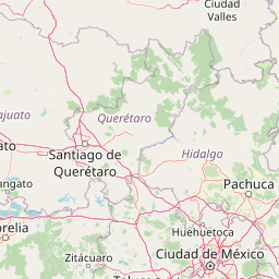
Map view of Los Remedios National Park

Use this park location map to pinpoint Los Remedios National Park in Mexico, understand its exact geographic position, and read its mapped placement within the surrounding landscape more clearly.

Pigeon | © OpenStreetMap contributors

Location context for Los Remedios National Park

Mexico State
Park atlas

Map the Regional Spread of Protected Areas and Compare Park Geography Near Mexico City.

Browse National Parks and Protected Areas Surrounding Los Remedios National Park

After exploring Los Remedios National Park, continue your discovery by browsing nearby protected areas and national parks that share the unique mountainous terrain and historical landscapes of the western Valley of Mexico. Comparing these regional parks offers valuable geographic context and highlights the diverse conservation efforts across similar cultural and natural environments.
National parkMexico
About 16 km away#1 closest

East

El Tepeyac National Park: Protected National Park Landscape and Regional Geography

Explore mapped boundaries and the park's geographic context.

Gain a detailed understanding of El Tepeyac National Park, a protected national park situated within Mexico. This entry provides essential geographic context, focusing on its mapped boundaries and its role as a protected landscape. It is designed to support users interested in the atlas-level exploration of natural areas, offering foundational information about the park's identity and its position within the broader geographic framework of Mexico.

Area
15 km²
Established
1937
IUCN
VI
Relief
Upland
National parkMexico City
About 19 km away#2 closest

South

Desierto de los Leones National Park: Protected National Park and its Geographic Setting

Explore mapped boundaries and regional landscape context near Mexico City.

Delve into the specifics of Desierto de los Leones National Park, a designated national park recognized for its protected landscape. This MoriAtlas entry focuses on its geographic presence within the Mexico City region, providing clear insights into its mapped boundaries and the surrounding natural terrain. Understand the park's importance as a conservation area and its contribution to the regional geography through dedicated atlas data.

Area
18.67 km²
Established
1917
IUCN
II
Visitors
205K annual
National parkMexico
About 22 km away#3 closest

South

Fuentes Brotantes de Tlalpan National Park: National Park Geographic Atlas and Terrain Exploration

Explore protected land boundaries and mapped natural landscapes.

Delve into the geographic specifics of Fuentes Brotantes de Tlalpan National Park, a protected national park situated within Mexico. This detailed view highlights the park's mapped terrain and its significance as a distinct natural landscape. Understand its role in the country's protected area network and its contribution to the broader atlas of natural geography.

Area
0.08 km²
Established
1936
IUCN
II
Relief
Upland
National parkMexico City
About 23 km away#4 closest

Southeast

Cerro de la Estrella National Park: Mapped Protected Landscape and Regional Geography

Explore the national park's mapped boundaries within Mexico City.

Cerro de la Estrella National Park represents a key protected area for geographic study and atlas exploration within the urban landscape of Mexico City. This entry provides detailed insight into the park's mapped boundaries and its role as a national park, highlighting its unique protected landscape character. Understand its position within the regional geography and explore what makes this park an important feature for mapped terrain and conservation awareness.

Area
1.5 km²
Established
1938
IUCN
II
Relief
Mixed relief
National parkMexico
About 24 km away#5 closest

Southwest

La Marquesa National Park: Atlas of Protected Highland Forests in Mexico's Sierra de las Cruces

Explore its mapped boundaries and regional geographic context.

La Marquesa National Park represents a critical protected natural zone in Mexico's central highlands, specifically within the Sierra de las Cruces mountain range. Its landscape is defined by rugged volcanic terrain, featuring steep slopes and deep ravines densely covered by pine and oak woodlands. Designated as an early national park, it plays a crucial role in watershed protection for the surrounding region, preserving unique highland forest ecosystems and their associated biodiversity. This park offers a tangible example of protected landscape within Mexico's atlas, highlighting its ecological significance and geographic positioning.

IUCN
II
Protected landscapeEstado de México
About 28 km away#6 closest

East

Parque Ecológico Lago de Texcoco: Mapped Protected Landscape and Regional Geography

A large-scale wetland and ecological restoration project in the Valley of Mexico.

Parque Ecológico Lago de Texcoco stands as a significant protected landscape, transforming a drained lacustrine basin into a vibrant mosaic of saline vegetation and water regulation zones. As an internationally recognized Ramsar wetland and Important Bird Area, the site offers a deep look into the ecological recovery of the Valley of Mexico. The terrain is defined by its flat basin character, ancient archaeological remnants on elevated hill areas, and a expansive network of restored water systems.

Area
140 km²
Established
2024
Relief
Lowland
Climate
Temperate
National parkMexico
About 29 km away#7 closest

South

Cumbres del Ajusco National Park: Exploring Mexico's National Park Protected Landscape

Discover mapped boundaries and regional geography.

Cumbres del Ajusco National Park is an important national park offering rich opportunities for geographic exploration. This detailed profile focuses on its identity as a protected landscape within Mexico, providing essential context for map-based discovery. Understand the park's specific location, its mapped territory, and its role within the nation's network of conservation areas, facilitating a structured atlas view.

Area
9.2 km²
Established
1936
IUCN
II
Relief
Mountain
Protected landscapeEstado de México
About 39 km away#8 closest

Southwest

Ciénegas del Lerma: Protected Highland Wetland Landscape in the State of Mexico

Mapping the upper Lerma River basin and remnant marsh ecosystems.

Ciénegas del Lerma serves as a significant protected landscape in central Mexico, encompassing three main lakes and extensive marshland corridors. This atlas entry details the site's hydrological structure, encompassing open-water zones and alluvial soils that support diverse aquatic vegetation and endemic species within a human-influenced highland setting.

Area
30.23 km²
Established
2002
IUCN
VI
Relief
Upland

Common questions about visiting, size, designation, and location context for Los Remedios National Park

Los Remedios National Park FAQs for park facts, access, geography, and protected area context

Find quick answers about Los Remedios National Park, including protected-area facts, park geography, trail and visitor context, and how the park fits into its surrounding country and regional landscape.
MoriAtlas Explorer

Continue Your Protected Areas Search Across the Global Atlas

Deepen your exploration by continuing the structured search for national parks and protected areas worldwide. Utilize the comprehensive filtering capabilities to compare different conservation landscapes and refine your understanding of global park geography. Discover more about the distribution and characteristics of protected natural areas.

Global natural geography