Ponds
Cooper Reservoir
2,486 m

A comprehensive atlas exploration of mountainous terrain, regional extents, and protected landscape characteristics.
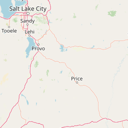
Examine the detailed physical geography of Manti–La Sal National Forest across Utah and Colorado. This profile captures the 5,143.09 square kilometer landscape extent, identifying its peak elevation of 3,877 meters alongside mapped watersheds, reservoirs, and forest habitats. Discover how these environmental markers define the protected mountain and plateau terrain within the regional geography.
A vast high-country forest spanning central Utah and western Colorado, crowned by the La Sal Mountains.
Manti-La Sal National Forest is a large federally managed forest that covers more than a million acres across the central and southeastern parts of Utah and the extreme western edge of Colorado. The forest stretches through a wide range of environments, from the forested highlands of the Wasatch Plateau to the high peaks of the La Sal Mountains, the second-highest mountain range in Utah. The landscape is unusually varied for a single national forest, combining cool montane forests of pine, aspen, and spruce with red rock desert canyons, sandstone plateaus, and remote wilderness country near the Colorado Plateau. Several famous national parks sit alongside or near its boundaries, including Arches, Canyonlands, and Bears Ears. The forest also holds meaningful recreation, scenic drives, and wilderness value. The Dark Canyon Wilderness on the Monticello Ranger District is the forest's only designated wilderness area, and segments of the forest are included within the Bears Ears National Monument, underscoring its role as both a working forest and a protected landscape of national significance.
Recorded country memberships and regional jurisdictions across the United States
Interactive boundary geometry and derived spatial measurements
Mountain relief features and recorded topographical data points
Ponds
2,486 m
Reservoirs
Peaks
2,722 m
Peaks
3,076 m
Streams
Streams
Temperate climate zones, montane forests, and mountain relief profiles
Mountains · Plateau · Lakes · Forest
Temperate coniferous forest · Montane forest
Compare adjacent mountain ranges, plateaus, and regional conservation landscapes
Southeast

Explore its vast geography and protected area boundaries.
Canyonlands National Park stands as a significant protected entity within the state of Utah, characterized by its immense scale and dramatic geological formations. This page facilitates an atlas-style exploration of its terrain, emphasizing its mapped boundaries and its crucial role as a protected landscape. Gain a deeper appreciation for its unique geographic setting and its place within the broader regional context.
East
Explore mapped terrain and geographic context.
Delve into the specifics of Arches National Park, a protected national park located in Utah. This atlas-focused entry provides detailed insight into the park's protected landscape features and geographic distribution. Understand the mapped park boundaries and the unique natural terrain that shapes this significant conservation area within the United States' broader regional geography.
Northwest
Exploring the high-elevation terrain and geological diversity of central Utah
Mount Nebo Wilderness offers a detailed look at the southern terminus of the Wasatch Range, featuring high-altitude summits, subalpine forested corridors, and the iconic badland formations of the Devil's Kitchen. This protected area provides a critical geographic anchor for the region, overlooking Utah Valley and connecting to the wider desert landscapes of the Great Basin through a series of rugged mountain canyons and high-elevation ridgelines.
South
Colorado Plateau canyons, sandstone strata, and reservoir environments
Explore the geological architecture of Glen Canyon National Recreation Area, a vast federal protected landscape. The area showcases towering Navajo Sandstone cliffs, deep blue reservoir arms, and remote backcountry canyons that exemplify the distinct high desert terrain of the Colorado Plateau in the United States.
East
Mapping the basalt-capped flat-top mountain terrain
Grand Mesa National Forest stands as a primary protected landscape within the Colorado Rockies, characterized by its signature basalt-capped plateau. This forest unit serves as a vital geographic landmark, offering unique insights into high-altitude mountain terrain, subalpine water systems, and historical forest conservation. Learn about the boundaries and physical landscape features that define this massive elevated tableland above the surrounding dry valleys.
North
An iconic Utah protected area within the northern Wasatch Range.
Mount Timpanogos Wilderness preserves a dramatic segment of the Wasatch Range, centering on an iconic summit that rises above glacial basins and forested slopes. This protected area offers a distinct study of alpine geology, featuring high-altitude cirques, steep ridges, and the prominent presence of Emerald Lake. As a critical piece of Utah wilderness, it anchors the skyline above the urban corridor, providing a concentrated look at regional mountain ecosystems and rugged natural terrain.
East
An expansive BLM wilderness area in western Colorado.
Dominguez Canyon Wilderness protects a diverse landscape of sandstone cliffs, benches, and deep drainage systems that descend from the Uncompahgre Plateau. The geography spans high-desert mesa tops and lush riparian canyons, offering a significant protected area within the Dominguez-Escalante National Conservation Area framework.
South
Explore Capitol Reef National Park's mapped terrain and boundaries.
Delve into the protected landscape and geographic identity of Capitol Reef National Park, a key national park in Utah. This resource provides detailed context on its mapped terrain and regional setting, supporting a structured understanding of protected areas for atlas exploration. Discover the specific geographic features and park boundaries that define this protected natural area.
Deepen your understanding of Manti–La Sal National Forest by examining its role within the broader Utah geographic framework. MoriAtlas provides a structured look at the forest's diverse terrain, from the high elevation peaks of the La Sal Mountains to the isolated mesas of the Colorado Plateau region.