

Mori Atlas logo
National parkMillstream Chichester National Park

Discover the geographic boundaries and natural terrain of this significant protected area.

Millstream Chichester National Park: Protected National Park and Mapped Landscape in Western Australia

Millstream Chichester National Park stands as a key protected natural landscape within Western Australia. This page offers a detailed atlas-driven perspective, focusing on the park's specific geographic boundaries, regional context within Western Australia, and the mapped terrain that defines its unique protected area identity. Understand its placement and intrinsic landscape characteristics for comprehensive geographic discovery.

riparian ecosystemsPilbara landscapeIndigenous heritagepermanent waterholessandstone rangesAustralian outback

Millstream Chichester National Park

National park

Park overview

Structured park overview, official facts, and landscape profile for Millstream Chichester National Park

Millstream Chichester National Park park facts, protected area profile, and essential visitor context
Review the core facts for Millstream Chichester National Park, including designation, size, terrain, visitor scale, habitats, and operating context in one park-focused overview.

About Millstream Chichester National Park

Millstream Chichester National Park occupies a unique position in the Pilbara, protecting a landscape where the harsh realities of an arid tropical environment are tempered by the presence of permanent water. The park was created from what was once Millstream Station, a pastoral lease that operated from the late 1860s onward, and the surrounding Chichester Range was set aside as a national park in 1970 before the Millstream area was added in 1982. Today the park encompasses approximately 2,381 square kilometres of diverse terrain, from the floodplains and channels of the Fortescue River system to the steep ridges and valleys of the Chichester Range. The Millstream Creek, named by explorer Francis Thomas Gregory in 1861, flows year-round in this region, providing the lifeblood that sustains the park's distinctive riparian vegetation and the wildlife that depends on these water sources. The park is located roughly 1,190 kilometres north of Perth and is accessible via the town of Roebourne in the Shire of Ashburton. The management of the park operates as a partnership between the Western Australian Department of Parks and Wildlife and the Yinjibarndi people through the Jirndawurrunhs Park Council, recognizing the deep and ongoing connection between Indigenous peoples and this Country.

Quick facts and research context for Millstream Chichester National Park

Located in the Pilbara region of Western Australia, this national park was established in 1970 and covers roughly 2,382 square kilometres. The park centres on Millstream Creek where it meets the Fortescue River, protecting both the riparian environment of these watercourses and the Chichester Range uplands. The nearest town is Roebourne. The park is managed by the Western Australian Department of Parks and Wildlife in collaboration with the Yinjibarndi people through the Jirndawurrunhs Park Council. Summer temperatures regularly exceed 40 degrees Celsius, while winter days are mild around 26 degrees.

Park context

Deeper park guide and search-rich context for Millstream Chichester National Park

Millstream Chichester National Park history, landscape, wildlife, and travel context
Explore Millstream Chichester National Park through its history, landscape character, ecosystems, wildlife, conservation priorities, cultural context, and seasonal travel timing in a structured park guide built for atlas discovery and search intent.

Why Millstream Chichester National Park stands out

Millstream Chichester is best known for its remarkable concentration of permanent waterholes in an otherwise arid landscape, creating a verdant riparian environment amid the rugged Pilbara. The deep pools such as Deep Reach Pool and Python Pool are central to both the park's ecological character and its cultural significance as places where the Rainbow Serpent Warlu is believed to dwell. The park also protects the Chichester Range, whose sandstone escarpments and gorges provide a dramatic backdrop to the green river corridors below. The contrast between the stark, red Pilbara landscape and these permanent water sources makes the park a striking example of how isolated watercourses create biodiversity hotspots in desert environments.

Millstream Chichester National Park history and protected-area timeline

The Millstream Chichester area has been occupied by Aboriginal people for thousands of years, with the Yinjibarndi people maintaining their homeland across the broad landscape straddling the Fortescue River from the Hamersley Range through to the Chichester escarpment. European exploration began with Francis Thomas Gregory naming Millstream Creek in 1861 after recognizing the favourable grazing prospects in the area. The first pastoral lease was taken up in 1865, and by 1907 the property covered some 2,590 square kilometres, supporting substantial numbers of sheep, cattle, and horses. The present Millstream Homestead was constructed in 1920 and later operated as a tavern from 1975 to 1986 before becoming the visitor centre that exists today. The Chichester Range National Park was officially declared in 1970, following recommendations from the Conservation through Reserves Committee in 1975. The Millstream region was incorporated into the park in 1982, creating the unified protected area that exists today. Yinjibarndi people continue to work as rangers and contractors within the park, maintaining their connection to Country while contributing to its ongoing management.

Millstream Chichester National Park landscape and geographic character

The park protects a visually dramatic landscape defined by the contrast between the rugged Chichester Range and the relatively lush riparian corridors of the Fortescue River and Millstream Creek. The Chichester Range consists of sandstone uplands that rise sharply from the surrounding Pilbara plains, creating steep escarpments and rocky valleys. Along Millstream Creek and the Fortescue River, the landscape transforms dramatically into dense stands of river red gum, coolabah, and pandanus trees that fringe the permanent waterholes. Deep Reach Pool, locally known as Nhanggangunha, is a particularly significant water body where the creek deepens into a substantial pool surrounded by vegetation. The floodplains of the Fortescue River support different vegetation communities, with samphire flats and tussock grasslands occurring in areas that experience periodic flooding. The overall impression is one of unexpected green in a landscape dominated by red earth and spinifex, a consequence of the reliable water supply that makes this area a biological refuge in the arid Pilbara.

Millstream Chichester National Park ecosystems, habitats, and plant life

The Pilbara is classified as an arid tropical environment, yet Millstream Chichester National Park supports surprisingly rich biodiversity due to its permanent water sources. The riparian zones along Millstream Creek and the Fortescue River contain distinct vegetation communities that contrast sharply with the surrounding spinifex grasslands and acacia shrublands of the broader Pilbara. River red gums and coolabah trees dominate the creek banks, while pandanus palms add a tropical character to the deeper pools. These riparian corridors provide critical habitat for numerous species that depend on permanent water, including various waterbirds, fish, and reptiles. The rocky outcrops and gorges of the Chichester Range support different plant communities adapted to steeper terrain and reduced water availability. The Pilbara region as a whole is recognised for its high level of endemism, with many species found nowhere else on Earth, and the park's variety of habitats ensures that this diversity is represented within its boundaries.

Millstream Chichester National Park wildlife and species highlights

The permanent waterholes of Millstream Chichester support wildlife populations that would be impossible in the surrounding arid terrain. The riparian vegetation provides habitat for a variety of bird species, with waterbirds particularly abundant around the deep pools where fishing and foraging opportunities exist. The rocky uplands of the Chichester Range are home to reptiles adapted to the harsh environment, including various goannas and snakes that utilise the crevices and shaded areas among the sandstone. Kangaroos and wallabies utilise the vegetation corridors along the watercourses, moving between the riparian zones and the surrounding slopes. The park's position in the Pilbara means that the wildlife assemblages reflect the intersection of tropical and desert influences, with species from both realms present in this unusual environment. The waterholes themselves are home to fish species adapted to surviving in the sometimes harsh conditions of these isolated pools.

Millstream Chichester National Park conservation status and protection priorities

Millstream Chichester National Park protects one of the few permanent river systems in the Pilbara, making it ecologically significant at both regional and national scales. The Fortescue River is one of the few reliable watercourses in this arid region, and the protection of its riparian ecosystems ensures that the unique biodiversity associated with these water sources is preserved for future generations. The park's inclusion of the Chichester Range adds further conservation value by protecting the mountainous terrain and its associated endemic species. The partnership between the Department of Parks and Wildlife and the Yinjibarndi people through the Jirndawurrunhs Park Council represents a contemporary approach to conservation that recognises Indigenous knowledge and ongoing connection to Country as essential components of effective protected area management. The park's IUCN Category II designation reflects its primary purpose of protecting natural landscapes and ecosystems while allowing for sustainable visitor use.

Millstream Chichester National Park cultural meaning and human context

The Millstream Chichester area holds extraordinary significance for the Yinjibarndi and Ngarluma peoples, whose traditional lands encompass this landscape. For the Yinjibarndi, the entire area from the Hamersley Range through to the Chichester escarpment is Country, while the Ngarluma people's lands extend from the Chichester escarpment northward to the sea. The park is particularly significant as the home of the serpent being Warlu, the Rainbow Serpent, whose presence is most strongly felt at Deep Reach Pool known in Yinjibarndi as Nhanggangunha. All the waterholes throughout the park hold spiritual and mythological importance, requiring respectful treatment from visitors. Beyond its spiritual significance, Millstream was historically an important gathering place where Aboriginal people from different clans would meet, with the reliable water and food resources of the Fortescue River supporting occupation even during drier months. The traditional diet included meat, fish, reptiles, eggs, honey, fruits, and root vegetables, while knowledge of waterhole locations was crucial for survival in this dry climate. The Millstream Homestead Visitor Centre includes displays dedicated to the Yinjibarndi people, early settlers, and the natural environment, and Indigenous people continue to visit the park to spend time on Country and carry out customary activities.

Top sights and standout views in Millstream Chichester National Park

The permanent waterholes of Millstream Chichester are the park's most striking feature, with deep pools like Deep Reach Pool and Python Pool providing unexpected green oases amid the red Pilbara landscape. The Chichester Range provides a dramatic backdrop, with its sandstone escarpments and panoramic views offering a contrast to the river corridors below. Cultural heritage is deeply embedded in the landscape, with the Yinjibarndi people's connection to this Country evident in the continued presence of Traditional Owners as rangers and park partners. The Millstream Homestead, built in 1920, now serves as a visitor centre offering insight into both the natural and cultural history of the area. The camping areas at Miliyanha and Stargazers provide opportunities to experience the park's atmosphere, particularly during the cooler months when daytime temperatures are moderate.

Best time to visit Millstream Chichester National Park

The optimal time to visit Millstream Chichester National Park is during the cooler season between May and August, when daytime temperatures hover around 26 degrees Celsius, making outdoor activities comfortable. Summer months from October to April bring extreme heat with temperatures regularly exceeding 40 degrees, along with the possibility of cyclones and intense thunderstorms that can cause flooding and road closures. During the wet season, access to some areas may be restricted and road conditions can become hazardous. The winter period offers more predictable conditions for camping and exploring, though night-time temperatures can be cool enough to require warm clothing. Visitors planning trips during the summer months should check current conditions with the Shire of Ashburton and be prepared for the possibility of closures during extreme weather events.
Park location guide

Geography guide, regional context, and park location map for Millstream Chichester National Park

Millstream Chichester National Park park geography, regions, and map view in Australia
Understand where Millstream Chichester National Park sits in Australia through a broader geographic reading of the surrounding landscape, nearby location context, and its mapped position within the national park landscape.

How Millstream Chichester National Park fits into Australia

Australia is a constitutional monarchy and federal parliamentary democracy comprising six states and ten territories. With a population of nearly 28 million, it is one of the world's most urbanised countries, with most people concentrated on the eastern seaboard. The country has a high Human Development Index and is known for its cultural diversity, ancient Aboriginal heritage, and unique wildlife.

Wider geography shaping Millstream Chichester National Park in Australia

Australia occupies the entire Australian continent, the island of Tasmania, and numerous smaller islands. It is the world's flattest and driest inhabited continent, featuring vast deserts in the interior (the Outback), tropical rainforests along the eastern coast, and a coastline bordering the Indian and Pacific Oceans.

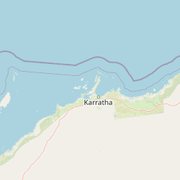
Map view of Millstream Chichester National Park

Use this park location map to pinpoint Millstream Chichester National Park in Australia, understand its exact geographic position, and read its mapped placement within the surrounding landscape more clearly.

Pigeon | © OpenStreetMap contributors

Location context for Millstream Chichester National Park

Western Australia
Park atlas

Compare the Pilbara's diverse protected landscapes and find other national parks in Western Australia

Discover Related National Parks and Protected Areas Near Millstream Chichester National Park
Continue your exploration of the Pilbara region's unique protected areas by comparing national parks and reserves located near Millstream Chichester National Park. This geographic overview helps you trace riverine oases, sandstone ranges, and Indigenous heritage sites across Western Australia's vast landscapes, offering deeper context for the region's conservation efforts.
National parkPilbara

Murujuga National Park: Pilbara Region's Protected Natural Landscape

Explore mapped park boundaries and regional geography.

Murujuga National Park represents a vital protected territory within the Pilbara region of Australia. This page provides focused atlas information on the park's geographic scope, mapped terrain, and its significance as a national park. Understand the unique landscape context of Murujuga National Park and its place within the broader regional geography, offering detailed insights for geographic exploration.

Area
48.51 km²
Established
2013
Climate
Arid
Access
Moderate access
National parkWestern Australia

Karijini National Park: Explore the Protected Landscape and Geographic Context in Western Australia

Mapped natural terrain and regional geography for this Australian national park.

Karijini National Park is a designated national park in Western Australia, offering a distinct protected landscape for geographic exploration. This detailed entry provides context on its specific location within the state, its mapped boundaries, and the surrounding natural terrain. It serves as a foundational element for understanding the park's role within the larger atlas of protected areas and natural geography across Australia.

Area
6,274.22 km²
Established
1969
IUCN
II
Visitors
166K annual
National parkWestern Australia

Mount Augustus National Park: Western Australia National Park & Protected Landscape

Explore its mapped terrain and regional geographic context.

Mount Augustus National Park represents a significant protected area within the diverse geography of Western Australia. This page serves as a portal to understanding its specific protected landscape characteristics and its contribution to the state's mapped natural areas. Users can explore the park's geographic identity, its defined boundaries, and its role within a broader atlas of protected lands, providing essential context for regional landscape discovery.

Area
91.68 km²
Established
1989
IUCN
III
Relief
Mountain
Watercolor illustration showing a coastal scene with shoreline, water, and landforms
National parkWestern Australia

Cape Range National Park: Exploring Western Australia's Protected Landscape Identity

Mapped boundaries and regional geographic context.

Cape Range National Park is a vital protected area located in Western Australia, offering a distinct geographic profile for atlas exploration. This entry focuses on its identity as a national park, detailing its mapped landscape and regional context. Users can discover the park's place within the state's diverse terrain and understand its significance as a mapped conservation area, contributing to a structured understanding of Australia's protected lands.

Area
476.55 km²
Established
1965
IUCN
II
Relief
Highland
National parkAustralia

Cape Range (South) National Park: Exploring Australia's Arid Semiarid Landscape Atlas

Mapped protected boundaries and regional terrain in Western Australia.

Cape Range (South) National Park, situated in Western Australia, is a vital protected area safeguarding a significant portion of the Carnarvon xeric shrublands. This national park offers a glimpse into a unique arid-zone landscape defined by low ranges, sandy plains, and characteristic acacia shrubland. Its establishment extends conservation efforts in the Gascoyne region, providing crucial context for mapped geography and the distribution of arid-adapted ecosystems within Australia's broader atlas.

Area
270.72 km²
Established
2020
IUCN
II
Relief
Upland
National parkGascoyne

Kennedy Range National Park: Explore Its Dramatic Sandstone Plateau and Canyon Geography

Discover the protected landscapes of Gascoyne's arid terrain.

Kennedy Range National Park is a protected area defined by its striking geological formations, including a vast sandstone plateau and deeply incised canyons that create a dramatic mesa landscape. Situated in the Gascoyne region, this national park serves as a significant example of Australia's inland semi-arid environments, offering rich context for mapped terrain exploration. Understand the park's protected boundaries, its unique arid-zone ecosystems, and the visual contrast it presents within the regional geography, providing valuable insights for atlas-driven discovery.

Area
1,416.6 km²
Established
1993
IUCN
II
Relief
Highland
National parkWestern Australia

Collier Range National Park National Park: Mapped Boundaries and Western Australia Geography

Discover protected area context and regional landscape features.

Collier Range National Park is a key protected area offering a focused lens into the diverse geography of Western Australia. This national park's mapped boundaries provide essential structure for understanding its place within the regional landscape. Explore the specific geographic context and protected-area identity of Collier Range National Park, contributing to a richer comprehension of Western Australia's natural terrain.

Area
2,351.62 km²
Established
1978
IUCN
II
Relief
Mixed relief
National parkGascoyne

Pimbee National Park: Australian National Park with Gascoyne Regional Geography

Mapped protected boundaries and natural landscape context.

Pimbee National Park represents a key protected area within Australia's vast Gascoyne region. This national park provides a specific geographic focus, allowing for detailed exploration of its mapped boundaries and the surrounding natural landscape. Understanding Pimbee National Park's place within the regional geography of Western Australia is crucial for a comprehensive atlas-driven discovery of the continent's protected lands and their unique terrain.

Established
2023
Climate
Arid
Scope
Terrestrial

Common questions about visiting, size, designation, and location context for Millstream Chichester National Park

Millstream Chichester National Park FAQs for park facts, access, geography, and protected area context
Find quick answers about Millstream Chichester National Park, including protected-area facts, park geography, trail and visitor context, and how the park fits into its surrounding country and regional landscape.
MoriAtlas Explorer

Continue Your Protected Areas Search Across the Global Atlas

Deepen your exploration by continuing the structured search for national parks and protected areas worldwide. Utilize the comprehensive filtering capabilities to compare different conservation landscapes and refine your understanding of global park geography. Discover more about the distribution and characteristics of protected natural areas.

Global natural geography