

Mori Atlas logo
National parkCape Range National Park

Discover the mapped boundaries and regional context of this national park.

Cape Range National Park: Protected Landscape and Geographic Identity in Western Australia

Cape Range National Park represents a significant protected area within the expansive geography of Western Australia. This detail page provides an atlas-centric view, focusing on the park's specific geographic identity and its role as a mapped natural landscape. Explore the protected boundaries and understand its unique place within Australia's broader conservation network, offering a grounded perspective for geographic discovery.

limestone landscapecaves and gorgesWestern AustraliaNorth West Capewildflower displaycoastal park
Illustration of a mountainous landscape featuring a winding river, waterfall, and forested hills under a sunny sky

Cape Range National Park

National park

Park overview

Structured park overview, official facts, and landscape profile for Cape Range National Park

Cape Range National Park park facts, protected area profile, and essential visitor context

Review the core facts for Cape Range National Park, including designation, size, terrain, visitor scale, habitats, and operating context in one park-focused overview.

About Cape Range National Park

Cape Range National Park protects a remarkable strip of Western Australia's coastline where ancient geological processes have created an extraordinary landscape of limestone plateaus, deep gorges, and pristine beaches. The park forms the backbone of the North West Cape peninsula, standing as the only elevated limestone plateau along this stretch of Australia's coast. Elevation reaches 314 meters at the highest points, with the terrain descending through rugged canyons carved by water erosion over millions of years. The park's creation in 1965 marked a significant achievement in Western Australia's conservation history, formalizing protection for an area that had previously supported pastoral activities beginning in the late 19th century. The surrounding Ningaloo Marine Park, declared in 1987, extends protection into the adjacent waters, creating a comprehensive conservation framework that encompasses both terrestrial and marine environments. Visitors to the park experience a landscape that transitions dramatically from arid spinifex-covered plains to lush canyon environments where permanent water sources support distinct vegetation communities.

Quick facts and research context for Cape Range National Park

Cape Range National Park occupies the western side of the North West Cape peninsula in Western Australia, with the town of Exmouth serving as the nearest population center. The park was established in 1965 and is managed by the Parks and Wildlife Service within the Department of Biodiversity, Conservation and Attractions. The landscape is defined by its limestone geology, with over 700 caves discovered within the park boundaries and many more likely remaining undiscovered. The park supports remarkable biodiversity including more than 630 wildflower species, 100 bird species, and 80 reptile species, alongside iconic Australian mammals such as rock wallabies, red kangaroos, emus, and euros.

Protection and recognition

Geographic analysis of terrestrial conservation boundaries and official database records

Documented Protection Status and Terrestrial Boundaries of Cape Range National Park

Natural resource planners and conservation researchers can examine the official terrestrial protection status and 1965 designation history of Cape Range National Park. Accessing verified regional boundary records and official database identifiers helps clarify the long term territorial framework of the coastal reserve.

Protection details

Protection scope
Terrestrial
Designated year
1965
Transboundary protection
No
WDPA ID
102112
Park context

Deeper park guide and search-rich context for Cape Range National Park

Cape Range National Park history, landscape, wildlife, and travel context

Explore Cape Range National Park through its history, landscape character, ecosystems, wildlife, conservation priorities, cultural context, and seasonal travel timing in a structured park guide built for atlas discovery and search intent.

Why Cape Range National Park stands out

Cape Range National Park is best known for its spectacular limestone landscape, which stands as a unique geological feature along Australia's western coastline. The park contains over 700 caves, making it one of the most cave-dense regions in the country, with many more expected to remain undiscovered. Yardie Creek, a dramatic gorge where water pools behind a sandbar, represents one of the park's most iconic visual landmarks. The park's flora is exceptionally diverse, with more than 630 wildflower species including the distinctive bird flower and desert sturt pea. Its position adjacent to Ningaloo Reef creates a rare transition from arid terrestrial landscapes to vibrant marine environments.
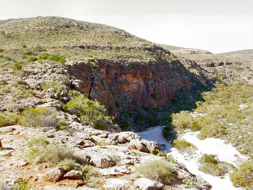
Rocky canyon landscape featuring steep cliffs, scattered shrubs, and a narrow waterway flowing through rugged terrain
Rocky canyon with sparse vegetation and a small stream in Cape Range National Park

Cape Range National Park history and protected-area timeline

The land now comprising Cape Range National Park has a history of human occupation extending back to Aboriginal peoples, though the more recent European history begins with pastoral settlement in the late 19th century. In 1876, J. Brockman acquired pastoral leases covering the North West Cape region, establishing cattle grazing operations in the area. In 1888, Brockman sold portions of his lease to ornithologist Thomas Carter, who purchased both Yardie Creek Station and Ningaloo Station. Carter became the first European settler in the area, formally establishing a pastoral station in 1889. The pastoral era continued for decades, but recognition of the region's unique natural values eventually led to protection. The area was declared a national park in 1964, with formal establishment following in 1965. In 1987, the offshore marine area adjacent to the park was declared as Ningaloo Marine Park, extending conservation protection to the reef ecosystem that lies just offshore from the Cape Range coastline.

Cape Range National Park landscape and geographic character

The landscape of Cape Range National Park is defined by its distinctive limestone geology, which sets it apart from surrounding regions along Western Australia's coast. The park occupies the western side of the North West Cape peninsula, forming a backbone of elevated plateaus that represent the only limestone-dominated highlands on the North West Coast of Australia. These plateaus rise to approximately 314 meters above sea level, creating a rugged and dramatic backdrop against the flat coastal plains and the Indian Ocean. Deep canyons have been carved into the limestone over geological time, carved by the flow of water that has gradually eroded the rock formation. The park encompasses numerous pristine beaches where the limestone meets the sea, creating sheltered coves and dramatic cliff faces. The landscape includes Yardie Creek, a particularly spectacular gorge where water accumulates behind a sandbar, creating a permanent pool in an otherwise arid landscape. The combination of elevation, erosion, and the proximity to the ocean has created a landscape of exceptional visual diversity within a relatively compact area.
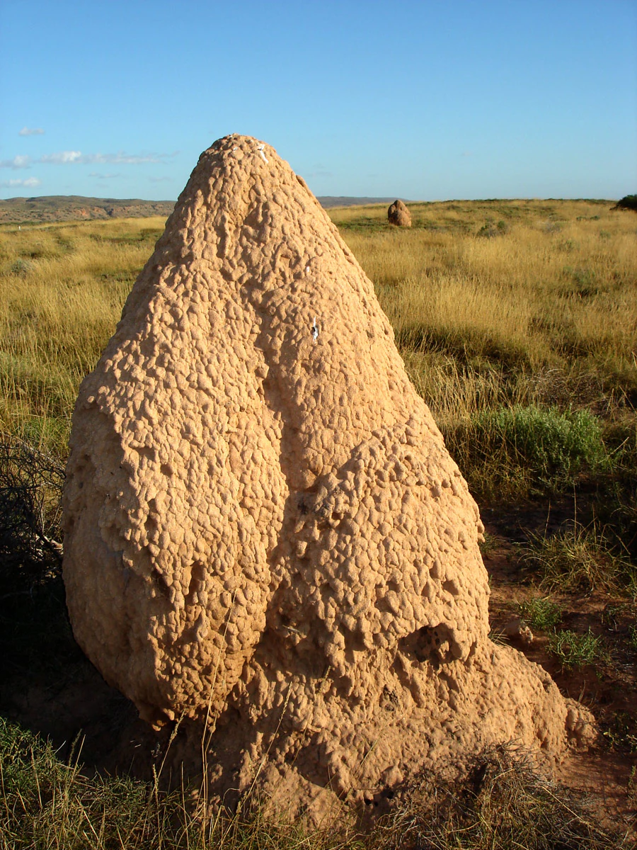
Large termite hill in a grassy field under clear blue sky
Termite hill in Cape Range National Park, Exmouth, Western Australia

Cape Range National Park ecosystems, habitats, and plant life

The nature of Cape Range National Park reflects the convergence of arid and semi-natural environments in a landscape shaped by limestone geology. The park supports an extraordinary diversity of plant life, with more than 630 species of wildflower documented within its boundaries. These wildflowers typically bloom toward the end of winter, transforming the landscape with color during the cooler months. Vegetation communities vary dramatically from the coast to the inland areas, with mangroves found in coastal zones, acacia woodlands on the plains, and specialized plants adapted to the rocky canyon environments. The park contains numerous endemic plant species adapted to the limestone substrate, including grevillea, verticordia, and the distinctive minilya lily. The arid portions of the park feature extensive spinifex grasslands, while the deeper canyons support more lush vegetation where water is available. The cave systems within the park represent a unique underground environment, with darkness-adapted ecosystems existing in the more than 700 documented caves.
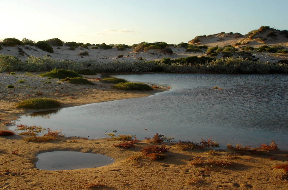
Sandy beach with a small body of water, low-lying vegetation, and sand dunes under a clear sky.
Landscape view of Cape Range National Park near Exmouth, Western Australia.

Cape Range National Park wildlife and species highlights

Cape Range National Park supports a rich diversity of wildlife despite its arid setting, with the limestone landscape creating numerous microhabitats that support both common and specialized species. Mammal species found within the park include rock wallabies, which are particularly well-suited to the rugged terrain and cliff faces, red kangaroos that traverse the open plains, euros (eastern wallaroos) that inhabit the rocky slopes, and emus that roam throughout the park. The birdlife is exceptionally diverse, with over 100 species documented including numerous parrots, honeyeaters, and desert-adapted species. Reptile diversity is equally impressive, with 80 species recorded including various snakes, lizards, and skinks adapted to the arid conditions. The park's caves provide habitat for specialized troglobitic species that have adapted to life in complete darkness. The proximity to Ningaloo Reef means that marine wildlife is also accessible from the park's coastline, with seasonal whale shark encounters possible in the adjacent waters.
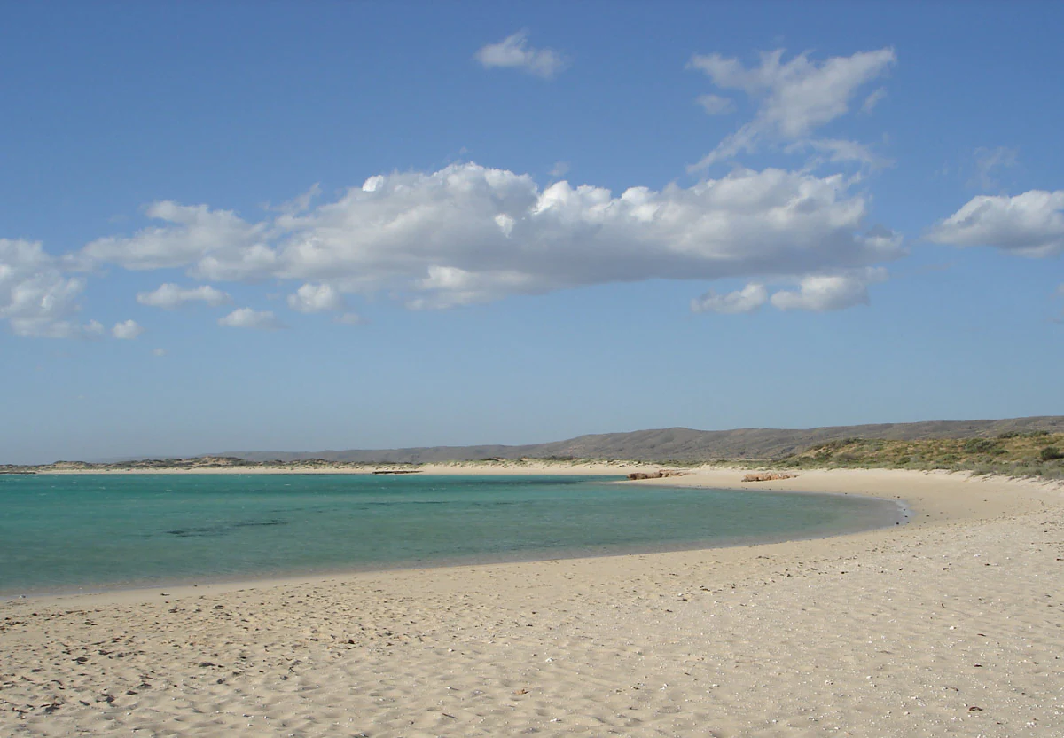
Sandy beach with turquoise water, scattered clouds, and distant hills under a clear blue sky.
Pristine sandy beach with turquoise water and distant hills under a clear blue sky.

Cape Range National Park conservation status and protection priorities

Cape Range National Park represents an important conservation outcome in Western Australia, protecting a unique geological landscape and the biodiversity it supports. The park's establishment in 1965 marked recognition of the region's outstanding natural values, particularly its distinctive limestone geology and the biodiversity associated with this rare landscape type. The protection extends beyond the terrestrial environment through the adjacent Ningaloo Marine Park, which was declared in 1987 to protect the reef ecosystem. Together, these protected areas create a comprehensive conservation framework spanning both land and sea. The park's cave systems represent a particularly significant conservation priority, with over 700 documented caves and the reasonable expectation that many more remain undiscovered. These caves provide habitat for specialized species and contain scientific information about the region's geological history. The wildflower diversity, with over 630 species, represents another significant conservation value, with many species endemic to the region.

Cape Range National Park cultural meaning and human context

The cultural context of Cape Range National Park encompasses both Aboriginal heritage and more recent European history. The traditional owners of the land have connections to the area that extend back thousands of years, with the park's landscape featuring in Aboriginal cultural knowledge and heritage. The European settlement history of the area began with pastoral leases in the late 19th century, with J. Brockman establishing the first recorded pastoral lease in 1876 covering the North West Cape. Thomas Carter became the first European settler when he established Yardie Creek Station in 1889, purchasing parts of the original lease. The pastoral era left lasting modifications to the landscape, though the transition to national park status in 1965 removed the grazing pressure and allowed natural processes to resume. The park also contains historical infrastructure from World War II, including radar towers at Vlamingh Head, reflecting the strategic importance of this coastline during the mid-20th century.

Top sights and standout views in Cape Range National Park

Cape Range National Park offers several standout features that make it distinctive among Western Australia's protected areas. The limestone plateau landscape is unique on Australia's North West Coast, providing dramatic scenery with elevation changes of over 300 meters and deep canyons carved over millions of years. The park contains over 700 caves, with the probability that many more remain undiscovered, making it one of the most cave-dense regions in Australia. Yardie Creek Gorge represents a particularly spectacular feature, where permanent water pools behind a sandbar in a dramatic canyon setting. The wildflower display in late winter is exceptional, with over 630 species including the iconic bird flower and desert sturt pea. The park's adjacency to Ningaloo Reef creates a rare opportunity to experience both terrestrial and marine environments in a single visit, with the reef accessible directly offshore from the park's coastline.

Best time to visit Cape Range National Park

The optimal time to visit Cape Range National Park is during the cooler months of autumn and winter, from April through September, when temperatures are more comfortable for outdoor exploration. Wildflower season typically peaks toward the end of winter, from late August through September, when the bloom of over 630 wildflower species transforms the landscape with color. Summer months from December through February bring intense heat that can make outdoor activities challenging, though early morning excursions remain possible. The park can be visited year-round, but the shoulder seasons of autumn and spring offer the most comfortable conditions for hiking and exploration. The marine environment of adjacent Ningaloo Reef is accessible year-round, though different seasons offer different wildlife experiences, with whale sharks typically present from March to July.
Park guides

Targeted answers for navigating Western Australia limestone terrain

Cape Range National Park Focused Guide Preview and Planning Insights

Selected reference materials provide focused answers for evaluating seasonal timing across the limestone plateaus and coastal canyons. Core publication themes address optimal visiting periods for exploring rugged protected terrain safely.
Monthly climate preview

Analyzing long-term temperature patterns and precipitation variations in Western Australia

Cape Range National Park Monthly Climate Normals and Weather Averages

Long-term climate data at a representative coordinate highlights a warm arid environment where average monthly maximums climb above thirty degrees Celsius. Exploring the complete twelve-month database reveals the detailed seasonal cycle of temperature and daily precipitation averages for Cape Range National Park.
Annual mean25 °C
22 °C28 °C
Jan26°
Feb27°
Mar28°
Apr27°
May25°
Jun23°
Jul22°
Aug22°
Sep22°
Oct23°
Nov24°
Dec25°
Warmest month
March

27.9 °C

Coolest month
August

21.8 °C

Wettest month
June

2.1 mm/day

Driest month
October

0 mm/day

Park location guide

Geography guide, regional context, and park location map for Cape Range National Park

Cape Range National Park park geography, regions, and map view in Australia

Understand where Cape Range National Park sits in Australia through a broader geographic reading of the surrounding landscape, nearby location context, and its mapped position within the national park landscape.

How Cape Range National Park fits into Australia

Australia is a constitutional monarchy and federal parliamentary democracy comprising six states and ten territories. With a population of nearly 28 million, it is one of the world's most urbanised countries, with most people concentrated on the eastern seaboard. The country has a high Human Development Index and is known for its cultural diversity, ancient Aboriginal heritage, and unique wildlife.

Wider geography shaping Cape Range National Park in Australia

Australia occupies the entire Australian continent, the island of Tasmania, and numerous smaller islands. It is the world's flattest and driest inhabited continent, featuring vast deserts in the interior (the Outback), tropical rainforests along the eastern coast, and a coastline bordering the Indian and Pacific Oceans.

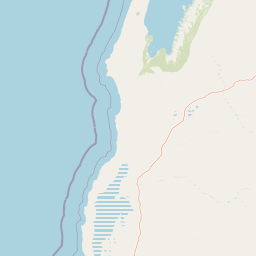
Map view of Cape Range National Park

Use this park location map to pinpoint Cape Range National Park in Australia, understand its exact geographic position, and read its mapped placement within the surrounding landscape more clearly.

Pigeon | © OpenStreetMap contributors

Location context for Cape Range National Park

Western Australia
Recorded earthquake history

Explore the Historical Earthquake Catalogue for Cape Range National Park

Review documented seismic events and recorded earthquake activity associated by proximity to Cape Range National Park. MoriAtlas provides this historical data to assist with geographic exploration of the region, detailing individual event magnitudes, depths, and epicentre locations relative to the park.

Cape Range National Park Earthquake History

Catalogued events

2 events

Strongest magnitude

Magnitude 4.4

Most recent event

Oct 6, 2006

This history includes earthquakes recorded inside the park or within 50 km of its borders

Explore key protected-area environments, dramatic gorges, and pristine beaches through detailed park imagery

Cape Range National Park Photos: Visualizing Western Australia's Unique Limestone Landscapes and Coastal Scenery

Explore visual insights into Cape Range National Park, revealing its dramatic limestone landscapes, deep canyons, and stunning coastal protected areas. These park images offer critical geographic context and illustrate the distinctive arid habitats, unique terrain features, and scenic beauty that define this remarkable Western Australian wilderness.

Rocky canyon landscape featuring steep cliffs, scattered shrubs, and a narrow waterway flowing through rugged terrain

Aerial view showing a coastal peninsula with rugged terrain adjacent to turquoise and deep blue ocean waters

Large termite hill in a grassy field under clear blue sky

Sandy beach with a small body of water, low-lying vegetation, and sand dunes under a clear sky.

Sandy beach with turquoise water, scattered clouds, and distant hills under a clear blue sky.

Park atlas

Trace the regional spread of protected areas and compare park geography across Australia's North West Cape.

Explore Other National Parks Near Cape Range National Park in Western Australia

Continue exploring other national parks and protected areas situated within Western Australia's unique coastal and arid ecosystems, including sites adjacent to the Ningaloo Reef. Browse mapped park geography to compare distinctive limestone landscapes, deep gorges, and diverse terrestrial-marine conservation zones across the North West Cape region.
Marine protected areaWestern Australia
6.4 km away#1 closest

Southwest

Ningaloo Marine Park: Mapping Western Australia's Protected Marine Geography and Habitats

Examining the oceanic shelf and reef environments of this key marine protected area

Ningaloo Marine Park safeguards a dynamic mosaic of shallow lagoons, reef edges, and deeper slope environments off the coast of Western Australia. This protected expanse is central to the regional conservation of whale shark feeding grounds and humpback whale migratory routes, offering a detailed perspective on the geomorphological character of the Central Western Shelf Transition.

Area
2,435 km²
Established
1987
IUCN
IV
Relief
Lowland
National parkAustralia
13 km away#2 closest

South

Cape Range (South) National Park: Exploring Australia's Arid Semiarid Landscape Atlas

Mapped protected boundaries and regional terrain in Western Australia.

Cape Range (South) National Park, situated in Western Australia, is a vital protected area safeguarding a significant portion of the Carnarvon xeric shrublands. This national park offers a glimpse into a unique arid-zone landscape defined by low ranges, sandy plains, and characteristic acacia shrubland. Its establishment extends conservation efforts in the Gascoyne region, providing crucial context for mapped geography and the distribution of arid-adapted ecosystems within Australia's broader atlas.

Area
270.72 km²
Established
2020
IUCN
II
Relief
Upland
Marine protected areaWestern Australia
17 km away#3 closest

West

Gascoyne Marine Park: Protected Marine Geography and Seafloor Terrain Map

Marine protected area situated along the Western Australian coast

Gascoyne Marine Park encompasses a significant offshore region defined by its shallow continental shelf and varied seafloor structures. This protected marine area supports vital habitats for migratory species and contributes to the broader ecological network of the North-west Marine Parks system, offering a clear view of specialized aquatic environments through detailed mapping.

Area
81,766 km²
Established
2018
IUCN
IV
Relief
Lowland
Marine protected areaWestern Australia
210 km away#4 closest

Northeast

Montebello Islands Marine Park: Western Australia Marine Protected Area Atlas

Mapping tropical reefs and archipelago terrain

Montebello Islands Marine Park preserves a significant archipelago and its surrounding tropical marine environment off the Pilbara coast. The area features extensive reef flats, mangrove communities, and deep oceanic waters that provide essential habitat for marine life and nesting sea turtles. Its physical profile includes a unique mix of natural reef-building processes and human history, making it a key component of the Western Australian marine conservation landscape.

Area
583.44 km²
Established
2004
IUCN
II
Relief
Lowland
National parkGascoyne
232 km away#5 closest

Southeast

Kennedy Range National Park: Explore Its Dramatic Sandstone Plateau and Canyon Geography

Discover the protected landscapes of Gascoyne's arid terrain.

Kennedy Range National Park is a protected area defined by its striking geological formations, including a vast sandstone plateau and deeply incised canyons that create a dramatic mesa landscape. Situated in the Gascoyne region, this national park serves as a significant example of Australia's inland semi-arid environments, offering rich context for mapped terrain exploration. Understand the park's protected boundaries, its unique arid-zone ecosystems, and the visual contrast it presents within the regional geography, providing valuable insights for atlas-driven discovery.

Area
1,416.6 km²
Established
1993
IUCN
II
Relief
Highland
National parkWestern Australia
308 km away#6 closest

East

Millstream Chichester National Park: A Mapped Protected Landscape in Western Australia

Explore its geographic spread and natural terrain features.

Millstream Chichester National Park is a designated national park within the vast geographic expanse of Western Australia. This entry provides detailed atlas-level information focused on its protected boundaries and distinct landscape characteristics. Understand the park's role within the regional geography and its significance as a mapped natural area for discovery and exploration.

Area
2,381.67 km²
Established
1970
IUCN
II
Relief
Mixed relief
National parkPilbara
312 km away#7 closest

Northeast

Murujuga National Park: Pilbara Region's Protected Natural Landscape

Explore mapped park boundaries and regional geography.

Murujuga National Park represents a vital protected territory within the Pilbara region of Australia. This page provides focused atlas information on the park's geographic scope, mapped terrain, and its significance as a national park. Understand the unique landscape context of Murujuga National Park and its place within the broader regional geography, offering detailed insights for geographic exploration.

Area
48.51 km²
Established
2013
Climate
Arid
Access
Moderate access
Marine protected areaWestern Australia
341 km away#8 closest

Northeast

Dampier Marine Park: Geographic Overview and Marine Protected Area Mapping

Protected shelf ecosystems of the Pilbara coast, Western Australia

Dampier Marine Park spans a mosaic of shallow shelf waters near the Dampier Archipelago. This protected area integrates diverse management zones to support migratory pathways for marine megafauna and preserve benthic habitats across the Northwest Shelf Province. Understanding its boundaries provides insight into the intersection of conservation and marine spatial planning in one of Australia's most significant coastal bioregions.

Area
1,252 km²
Established
2018
IUCN
VI
Relief
Lowland

Common questions about visiting, size, designation, and location context for Cape Range National Park

Cape Range National Park FAQs for park facts, access, geography, and protected area context

Find quick answers about Cape Range National Park, including protected-area facts, park geography, trail and visitor context, and how the park fits into its surrounding country and regional landscape.
MoriAtlas Explorer

Continue Your Protected Areas Search Across the Global Atlas

Deepen your exploration by continuing the structured search for national parks and protected areas worldwide. Utilize the comprehensive filtering capabilities to compare different conservation landscapes and refine your understanding of global park geography. Discover more about the distribution and characteristics of protected natural areas.

Global natural geography