Mori Atlas logo
National parkCape Range (South) National Park

Mapping the arid zone terrain and protected boundaries within Australia's Gascoyne region.

Cape Range (South) National Park: Discover its Semiarid Landscape & Protected Area Geography

Cape Range (South) National Park represents a significant addition to Australia's protected lands, safeguarding a distinctive semiarid environment within the Carnarvon xeric shrublands bioregion. This national park preserves a unique terrestrial landscape characterized by low broken ranges, sandy plains, and acacia-dominated shrublands. As part of a broader conservation network near the Ningaloo Coast, its mapped boundaries contribute to the understanding of regional geography and the protection of unique arid-zone biodiversity.

National ParkWestern AustraliaSemiarid LandscapeXeric ShrublandsArid ZoneProtected Area

Cape Range (South) National Park

National park

Park overview

Structured park overview, official facts, and landscape profile for Cape Range (South) National Park

Cape Range (South) National Park park facts, protected area profile, and essential visitor context
Review the core facts for Cape Range (South) National Park, including designation, size, terrain, visitor scale, habitats, and operating context in one park-focused overview.

About Cape Range (South) National Park

Cape Range (South) National Park represents a significant recent expansion of Western Australia's national park estate, protecting a portion of the semiarid landscape that characterizes the state's central coastline. The park is situated in the Gascoyne region, an area of low rainfall and sparse population where vast distances separate isolated communities. The landscape consists of undulating terrain dominated by low rocky ranges and extensive sandy plains, with vegetation adapted to survive in conditions of prolonged aridity. The park lies immediately south of the original Cape Range National Park, established in 1964, and together these protected areas preserve a substantial tract of the region's natural landscape. The Carnarvon xeric shrublands bioregion encompasses much of this portion of Western Australia, representing one of the state's major arid-zone ecosystems. The establishment of this new national park in 2020 reflects ongoing efforts by Western Australia's conservation agency to identify and protect areas of significant ecological and landscape value, particularly in regions where the combination of remoteness and sparse development has allowed natural values to persist relatively intact.

Quick facts and research context for Cape Range (South) National Park

Cape Range (South) National Park is located in the Gascoyne region of Western Australia, within the Shire of Exmouth. The park was officially declared on 4 November 2020, making it one of the more recent additions to the state's national park system. It occupies a contiguous area south of the original Cape Range National Park, which has protected the broader Cape Range landscape since 1964. The park falls within the Carnarvon xeric shrublands bioregion, an extensive area of semiarid shrubland that spans much of central Western Australia. Administration is handled by the Department of Biodiversity, Conservation and Attractions.

Park context

Deeper park guide and search-rich context for Cape Range (South) National Park

Cape Range (South) National Park history, landscape, wildlife, and travel context
Explore Cape Range (South) National Park through its history, landscape character, ecosystems, wildlife, conservation priorities, cultural context, and seasonal travel timing in a structured park guide built for atlas discovery and search intent.

Why Cape Range (South) National Park stands out

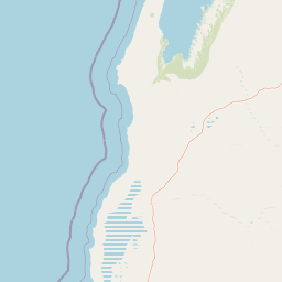
Cape Range (South) National Park is most notable for its role in extending protection to a portion of the Carnarvon xeric shrublands, a bioregion recognized for its distinctive arid-zone biodiversity and ancient landscape character. The park sits in proximity to the Ningaloo Coast, a UNESCO World Heritage site known for its extraordinary marine and terrestrial values. While the park itself focuses on terrestrial semiarid environments, it forms part of a broader conservation landscape that includes coastal dunes, limestone ranges, and acacia-dominated shrublands. The protected area also connects with the older Cape Range National Park, creating a larger contiguous block of protected land that preserves the natural values of this remote coastal region.

Cape Range (South) National Park history and protected-area timeline

Cape Range (South) National Park was officially declared on 4 November 2020, making it one of the newest national parks in Western Australia. The park was created through a deliberate expansion of the state's protected area network, specifically targeting the southern portion of the Cape Range landscape that had previously lacked formal national park protection. This declaration followed the existing Cape Range National Park, which was established in 1964 and protects the core of the Cape Range landscape. The decision to create a separate park entity for the southern portion reflects both the administrative boundaries of the area and the desire to ensure dedicated management focus for this section of the range. The park falls within the Shire of Exmouth, the local government area that also encompasses the coastal town of Ningaloo and the southern portions of the Ningaloo Coast World Heritage Area. Administration of the park is the responsibility of the Department of Biodiversity, Conservation and Attractions, the state agency responsible for managing Western Australia's conservation estate.

Cape Range (South) National Park landscape and geographic character

The landscape of Cape Range (South) National Park is characteristic of the Carnarvon xeric shrublands, a semiarid environment defined by low, often broken ranges, extensive sandy and gravelly plains, and scattered drainage lines. The terrain is dominated by ancient geology, with the Cape Range itself representing a series of low limestone and sandstone ridges that protrude from the surrounding plain. Vegetation across the park consists of shrubland dominated by various acacia species, with an understory of grasses and herbs that becomes more prolific after seasonal rainfall. The color palette of the landscape is typically muted greens and greys, punctuated by the silver-grey foliage of Acacia species and the seasonal flush of wildflowers that follows irregular rainfall events. While the park does not include significant coastal areas itself, it lies relatively close to the Ningaloo coast and shares much of the same broader landscape character as the better-known coastal sections to the west.

Cape Range (South) National Park ecosystems, habitats, and plant life

The nature of Cape Range (South) National Park is defined by the ecological characteristics of the Carnarvon xeric shrublands bioregion, one of Australia's major arid-zone bioregions. This bioregion supports a range of habitats including shrubland, grassland, and open woodland, with species compositions that vary according to soil type, elevation, and proximity to drainage systems. The vegetation is dominated by shrubby species from the genera Acacia and other families adapted to low rainfall and high temperatures. Wildlife in the region includes a variety of reptiles, small mammals, and birds that have evolved to cope with the challenges of arid environments, including nocturnal lifestyles, water-efficient physiology, and the ability to exploit irregular rainfall events. The region is known for its biodiversity relative to other arid areas, with many species endemic to the Carnarvon basin or the Western Australian arid zone more broadly. The park's protection within the national park system ensures that these ecological values are preserved as part of Western Australia's conservation estate.

Cape Range (South) National Park wildlife and species highlights

The wildlife of the Cape Range (South) area reflects the broader fauna of the Carnarvon xeric shrublands, an arid-zone bioregion that supports a surprising diversity of species despite its harsh conditions. Reptiles form a significant component of the fauna, with various snake and lizard species adapted to the desert environment. Small mammals, including several species of native rodents, occupy the shrubland and woodland habitats, while larger mammals such as kangaroos and wallabies are present in appropriate habitats. Birdlife is represented by a mix of desert-adapted species and those that utilize the more vegetated drainage lines and woodland areas. The region is home to numerous bird species that have adapted to arid conditions, including various honeyeaters, parrots, and ground-dwelling species. Like other parts of the Western Australian arid zone, this area supports species that are found nowhere else on Earth, reflecting the long period of isolation and unique evolutionary pressures that have shaped the region's fauna.

Cape Range (South) National Park conservation status and protection priorities

Cape Range (South) National Park contributes to the conservation of Western Australia's semiarid and arid-zone biodiversity by protecting a section of the Carnarvon xeric shrublands that had not previously received formal national park status. The establishment of this park in 2020 expanded the total area of land under national park protection in the Cape Range region, complementing the older Cape Range National Park to the north. The Carnarvon xeric shrublands bioregion is recognized as an area of significant ecological value, supporting both representative arid-zone ecosystems and species of conservation concern. By incorporating this area into the national park system, Western Australia has ensured that the natural values of this semiarid landscape are maintained for future generations. The park also contributes to the broader conservation network that includes the nearby Ningaloo Coast World Heritage Area, creating a connected set of protected areas that span both coastal and inland environments.

Cape Range (South) National Park cultural meaning and human context

The cultural context of Cape Range (South) National Park lies within the broader cultural landscape of the Gascoyne region and the traditional lands of Aboriginal peoples who have inhabited this area for tens of thousands of years. While the source material does not provide specific detail on indigenous heritage values for this particular park, the broader Cape Range area and the Ningaloo coast are known to contain sites of indigenous significance. The establishment of the national park in 2020 reflects contemporary recognition of both ecological and cultural values in protected area management. The park is situated within the Shire of Exmouth, a region that encompasses both the modern town of Exmouth and areas of continuing indigenous cultural importance.

Top sights and standout views in Cape Range (South) National Park

Cape Range (South) National Park offers protection for a distinctive section of Western Australia's semiarid interior, extending the reach of formal conservation into a landscape that represents the Carnarvon xeric shrublands bioregion. The park's adjacency to the older Cape Range National Park creates a larger contiguous protected area that preserves the natural values of this remote coastal region. The landscape features low broken ranges, sandy plains, and acacia-dominated shrubland characteristic of Australia's arid zone. The park lies within driving distance of the Ningaloo Coast, allowing visitors to combine exploration of the inland semiarid landscapes with the famous coastal environments of the World Heritage Area.

Best time to visit Cape Range (South) National Park

The best time to visit Cape Range (South) National Park is during the cooler months of the year, typically from April to October, when daytime temperatures are more comfortable for outdoor exploration. Summer months in the Western Australian desert can bring extreme heat, limiting the practicality of extended outdoor activities. The region experiences low annual rainfall, with most precipitation occurring during the summer cyclone season or during sporadic winter rain events. Visitors planning trips to the park should be aware of the remote nature of the area and ensure adequate supplies, fuel, and communications equipment are carried. The park can be visited year-round, but spring and autumn generally offer the most pleasant conditions for exploring the semiarid landscape.

Park location guide

Geography guide, regional context, and park location map for Cape Range (South) National Park

Cape Range (South) National Park park geography, regions, and map view in Australia
Understand where Cape Range (South) National Park sits in Australia through a broader geographic reading of the surrounding landscape, nearby location context, and its mapped position within the national park landscape.

How Cape Range (South) National Park fits into Australia

Australia is a constitutional monarchy and federal parliamentary democracy comprising six states and ten territories. With a population of nearly 28 million, it is one of the world's most urbanised countries, with most people concentrated on the eastern seaboard. The country has a high Human Development Index and is known for its cultural diversity, ancient Aboriginal heritage, and unique wildlife.

Wider geography shaping Cape Range (South) National Park in Australia

Australia occupies the entire Australian continent, the island of Tasmania, and numerous smaller islands. It is the world's flattest and driest inhabited continent, featuring vast deserts in the interior (the Outback), tropical rainforests along the eastern coast, and a coastline bordering the Indian and Pacific Oceans.

Map view of Cape Range (South) National Park

Use this park location map to pinpoint Cape Range (South) National Park in Australia, understand its exact geographic position, and read its mapped placement within the surrounding landscape more clearly.

Pigeon | © OpenStreetMap contributors

Location context for Cape Range (South) National Park

GascoyneWestern Australia
Park atlas

Map nearby protected areas, tracing their geographic spread and diverse landscapes across Western Australia's Gascoyne region.

Explore Other National Parks Near Cape Range (South) National Park and Western Australia's Xeric Shrublands
Discover other national parks and protected areas surrounding Cape Range (South) National Park, allowing comparison of semiarid landscapes and adjacent conservation efforts within Western Australia's Gascoyne region. Explore the geographic spread of arid-zone biodiversity and the broader interconnectedness of protected terrains, expanding your atlas view of this unique continental area.
Watercolor illustration showing a coastal scene with shoreline, water, and landforms
National parkWestern Australia

Cape Range National Park: Exploring Western Australia's Protected Landscape Identity

Mapped boundaries and regional geographic context.

Cape Range National Park is a vital protected area located in Western Australia, offering a distinct geographic profile for atlas exploration. This entry focuses on its identity as a national park, detailing its mapped landscape and regional context. Users can discover the park's place within the state's diverse terrain and understand its significance as a mapped conservation area, contributing to a structured understanding of Australia's protected lands.

Area
476.55 km²
Established
1965
IUCN
II
Relief
Highland
National parkGascoyne

Kennedy Range National Park: Explore Its Dramatic Sandstone Plateau and Canyon Geography

Discover the protected landscapes of Gascoyne's arid terrain.

Kennedy Range National Park is a protected area defined by its striking geological formations, including a vast sandstone plateau and deeply incised canyons that create a dramatic mesa landscape. Situated in the Gascoyne region, this national park serves as a significant example of Australia's inland semi-arid environments, offering rich context for mapped terrain exploration. Understand the park's protected boundaries, its unique arid-zone ecosystems, and the visual contrast it presents within the regional geography, providing valuable insights for atlas-driven discovery.

Area
1,416.6 km²
Established
1993
IUCN
II
Relief
Highland
National parkGascoyne

Pimbee National Park: Australian National Park with Gascoyne Regional Geography

Mapped protected boundaries and natural landscape context.

Pimbee National Park represents a key protected area within Australia's vast Gascoyne region. This national park provides a specific geographic focus, allowing for detailed exploration of its mapped boundaries and the surrounding natural landscape. Understanding Pimbee National Park's place within the regional geography of Western Australia is crucial for a comprehensive atlas-driven discovery of the continent's protected lands and their unique terrain.

Established
2023
Climate
Arid
Scope
Terrestrial
National parkWestern Australia

Mount Augustus National Park: Western Australia National Park & Protected Landscape

Explore its mapped terrain and regional geographic context.

Mount Augustus National Park represents a significant protected area within the diverse geography of Western Australia. This page serves as a portal to understanding its specific protected landscape characteristics and its contribution to the state's mapped natural areas. Users can explore the park's geographic identity, its defined boundaries, and its role within a broader atlas of protected lands, providing essential context for regional landscape discovery.

Area
91.68 km²
Established
1989
IUCN
III
Relief
Mountain
National parkWestern Australia

Millstream Chichester National Park: A Mapped Protected Landscape in Western Australia

Explore its geographic spread and natural terrain features.

Millstream Chichester National Park is a designated national park within the vast geographic expanse of Western Australia. This entry provides detailed atlas-level information focused on its protected boundaries and distinct landscape characteristics. Understand the park's role within the regional geography and its significance as a mapped natural area for discovery and exploration.

Area
2,381.67 km²
Established
1970
IUCN
II
Relief
Mixed relief
National parkPilbara

Murujuga National Park: Pilbara Region's Protected Natural Landscape

Explore mapped park boundaries and regional geography.

Murujuga National Park represents a vital protected territory within the Pilbara region of Australia. This page provides focused atlas information on the park's geographic scope, mapped terrain, and its significance as a national park. Understand the unique landscape context of Murujuga National Park and its place within the broader regional geography, offering detailed insights for geographic exploration.

Area
48.51 km²
Established
2013
Climate
Arid
Access
Moderate access
National parkWestern Australia

Karijini National Park: Explore the Protected Landscape and Geographic Context in Western Australia

Mapped natural terrain and regional geography for this Australian national park.

Karijini National Park is a designated national park in Western Australia, offering a distinct protected landscape for geographic exploration. This detailed entry provides context on its specific location within the state, its mapped boundaries, and the surrounding natural terrain. It serves as a foundational element for understanding the park's role within the larger atlas of protected areas and natural geography across Australia.

Area
6,274.22 km²
Established
1969
IUCN
II
Visitors
166K annual
National parkWestern Australia

Kalbarri National Park: Discover Its Mapped Geography and Protected Landscape Identity

Western Australia's protected national park terrain.

Kalbarri National Park is a vital protected area within the vast geography of Western Australia. This detail entry provides essential context for understanding the park's specific protected landscape, its geographic features, and how it integrates into the broader regional atlas. Explore the mapped boundaries and natural terrain that define Kalbarri National Park, offering a foundation for deeper geographic study and protected-area discovery.

Area
1,830.05 km²
Established
1963
IUCN
II
Relief
Mixed relief

Common questions about visiting, size, designation, and location context for Cape Range (South) National Park

Cape Range (South) National Park FAQs for park facts, access, geography, and protected area context
Find quick answers about Cape Range (South) National Park, including protected-area facts, park geography, trail and visitor context, and how the park fits into its surrounding country and regional landscape.
MoriAtlas Explorer

Continue Your Protected Areas Search Across the Global Atlas

Deepen your exploration by continuing the structured search for national parks and protected areas worldwide. Utilize the comprehensive filtering capabilities to compare different conservation landscapes and refine your understanding of global park geography. Discover more about the distribution and characteristics of protected natural areas.

Global natural geography