

Mori Atlas logo
National parkPimbee National Park

Discover the mapped boundaries and regional terrain of this Australian national park.

Pimbee National Park: Protected Landscape and Geographic Context in Gascoyne

Pimbee National Park stands as a significant protected area within the Gascoyne region of Western Australia. As a designated national park, it offers a distinct natural landscape for exploration, characterized by its specific geographic setting and mapped boundaries. This page serves as a portal to understanding Pimbee National Park's unique identity within the broader atlas of protected lands, providing context for its regional geography and terrain.

National ParkWestern AustraliaArid LandscapesJoint ManagementIndigenous HeritageCarnarvon Xeric Shrublands

Pimbee National Park

National park

Park overview

Structured park overview, official facts, and landscape profile for Pimbee National Park

Pimbee National Park park facts, protected area profile, and essential visitor context
Review the core facts for Pimbee National Park, including designation, size, terrain, visitor scale, habitats, and operating context in one park-focused overview.

About Pimbee National Park

Pimbee National Park occupies a remote position in the Gascoyne region of Western Australia, an area characterized by its vast arid and semi-arid landscapes that extend across much of the state's interior. The park was formally established in August 2023, representing the culmination of conservation planning that began with a proposal for a Pimbee Conservation Park in 2019. This relatively recent establishment means the park is still developing its visitor infrastructure and management programs, but it represents a significant addition to Western Australia's protected area estate.

The park is situated within the Carnarvon xeric shrublands bioregion, a vast area of arid scrubland and grassland that spans much of the Gascoyne and into neighboring regions. This bioregion experiences low and highly variable rainfall, with vegetation adapted to survive prolonged dry periods and periodic flooding events. The landscape surrounding Pimbee includes typical arid-zone features such as stony plains, low hills, and drainage systems that only flow intermittently following rainfall.

Management of the park operates under a joint arrangement between the Yingkarta people, represented through the Yinggarda Aboriginal Corporation, and the Western Australian government's Department of Biodiversity, Conservation and Attractions. This model reflects evolving recognition of Indigenous rights and knowledge in conservation management. The creation of Pimbee National Park was accompanied by the expansion of Kennedy Range National Park, also on Yingkarta country, with plans to employ Yingkarta rangers based at Gascoyne Junction to support management of both areas.

Quick facts and research context for Pimbee National Park

Pimbee National Park is located in the Gascoyne region of Western Australia, situated about 180 kilometers southeast of Carnarvon within the Shire of Carnarvon. The park was formally declared in August 2023, making it one of the newest national parks in Western Australia. It falls within the Carnarvon xeric shrublands bioregion, an arid to semi-arid environment characterized by low and unpredictable rainfall. The park is co-managed by the Yinggarda Aboriginal Corporation and the Department of Biodiversity, Conservation and Attractions, operating on the traditional lands of the Yingkarta people. A conservation park proposal for the area was originally put forward in 2019 with an estimated size of 99,000 hectares.

Park context

Deeper park guide and search-rich context for Pimbee National Park

Pimbee National Park history, landscape, wildlife, and travel context
Explore Pimbee National Park through its history, landscape character, ecosystems, wildlife, conservation priorities, cultural context, and seasonal travel timing in a structured park guide built for atlas discovery and search intent.

Why Pimbee National Park stands out

Pimbee National Park is best known as a newly established protected area representing the Carnarvon xeric shrublands bioregion of Western Australia. The park is notable for its joint management arrangement with the traditional Yingkarta people through the Yinggarda Aboriginal Corporation, reflecting contemporary approaches to Indigenous co-management of protected lands. As an arid-zone protected area in the Gascoyne region, it contributes to the conservation of semi-desert ecosystems that are poorly represented in Australia's protected area network. The park's establishment also connected with the parallel expansion of Kennedy Range National Park, creating a broader contiguous conservation landscape on Yingkarta country.

Pimbee National Park history and protected-area timeline

The establishment of Pimbee National Park represents the culmination of several years of conservation planning and negotiation. A proposal for a Pimbee Conservation Park was developed in 2019, envisioning protection of approximately 99,000 hectares on the former Pimbee leasehold property located north of the Wooramel River. This proposal was subsequently listed as in progress within the 2022 Collaborative Australian Protected Areas Database, indicating ongoing work toward formal protection.

In August 2023, the Pimbee Conservation Park proposal was realized through the formal declaration of Pimbee National Park. This establishment occurred alongside a significant expansion of Kennedy Range National Park, which also lies within Yingkarta country. The parallel declarations reflected a coordinated approach to expanding protected area coverage in the Gascoyne region while establishing collaborative management frameworks with traditional owners. At the time of establishment, plans were announced for the employment of four Yingkarta rangers based at Gascoyne Junction to support management operations across both protected areas. This marked a practical step toward integrating Indigenous participation in the day-to-day management of these newly protected landscapes.

Pimbee National Park landscape and geographic character

The landscape of Pimbee National Park reflects the characteristic terrain of the Carnarvon xeric shrublands bioregion, an extensive area of arid Western Australia dominated by low-lying shrubland and open woodland on ancient landscapes. The terrain consists primarily of stony plains and gently undulating terrain, with occasional low ridges and hills breaking the otherwise flat horizon. Drainage lines, including the Wooramel River system to the south, create linear features through the landscape but typically carry water only intermittently following rainfall events in this region of highly variable precipitation.

Vegetation across the park consists of dense shrubland dominated by species adapted to arid conditions, including various acacia species, saltbush, and other chenopod shrubs that characterize much of Australia's arid interior. The low, open canopy of the shrubland allows for substantial ground exposure, with soils typically consisting of red-brown earths and stony mantles derived from the ancient continental basement rocks. The overall visual character is one of vast, open space with a tapestry of grey-green foliage punctuated by the occasional flowering of drought-resistant plants following rainfall.

Pimbee National Park ecosystems, habitats, and plant life

Pimbee National Park lies within the Carnarvon xeric shrublands bioregion, one of Australia's extensive arid-zone bioregions that support distinctive ecosystems adapted to harsh, water-limited conditions. The bioregion is characterized by shrubland communities dominated by acacias, eremophilas, and chenopod shrubs that form a mosaic across the landscape. These plant communities have evolved sophisticated adaptations to survive extended dry periods and capitalize on infrequent rainfall events that trigger brief periods of productivity.

The biodiversity of arid Western Australia, while less visually dramatic than tropical or temperate environments, includes numerous specialized species found nowhere else. The region's isolation has driven evolution of endemic species adapted to specific habitat niches within the scrubland environment. Birdlife includes various desert-adapted species, while reptiles constitute a significant component of the vertebrate fauna, with numerous lizard and snake species occupying different ecological roles within the arid ecosystem.

Pimbee National Park wildlife and species highlights

The wildlife of Pimbee National Park represents the adapted fauna of Australia's arid interior, a fauna that has evolved remarkable strategies for surviving in an environment characterized by extreme temperatures, limited water availability, and highly unpredictable resource availability. Reptiles form a major component of the vertebrate fauna, with various skinks, geckos, dragons, and snakes occupying the diverse microhabitats provided by the shrubland environment. These cold-blooded animals are well-suited to the variable thermal conditions, using burrows and shelter sites to moderate body temperature.

Bird species present include various parrots, honeyeaters, and birds of prey adapted to arid environments. Desert birds have evolved behaviors such as nomadism, moving in response to rainfall and resource availability across the vast arid zone. Mammals in similar arid environments tend to be small and nocturnal, sheltering during the heat of the day and emerging at night to forage. Kangaroos and wallabies occur in appropriate habitats, while small marsupials such as dunnarts and planigales occupy niche roles within the ecosystem.

Pimbee National Park conservation status and protection priorities

The establishment of Pimbee National Park contributes to the conservation estate in a region where protected area coverage has been limited relative to more populous parts of Australia. The Carnarvon xeric shrublands bioregion, while extensive, has historically had relatively little formal protection, making new protected areas like Pimbee significant for biodiversity conservation. The park helps protect representative examples of arid-zone ecosystems and the species they support.

The joint management arrangement with the Yingkarta people represents an important conservation model that combines western scientific conservation approaches with traditional Indigenous knowledge and land management practices. This collaborative framework is increasingly recognized as essential for effective conservation in Australian landscapes, particularly in remote arid zones where resources for park management are limited. The employment of Yingkarta rangers at Gascoyne Junction to manage Pimbee and the expanded Kennedy Range National Park demonstrates a practical commitment to Indigenous involvement in conservation management.

Pimbee National Park cultural meaning and human context

Pimbee National Park is situated on the traditional lands of the Yingkarta people, an Aboriginal group with deep historical connections to the arid landscapes of the Gascoyne region. The park's establishment explicitly acknowledges Yingkarta peoples as the traditional owners of the land, and the involvement of the Yinggarda Aboriginal Corporation in joint management reflects contemporary recognition of Indigenous rights and the value of traditional ecological knowledge in land stewardship.

The landscape has been part of Yingkarta Country for thousands of years, with Indigenous heritage values embedded in the physical and cultural landscape. The joint management arrangement represents not only a conservation milestone but also an important step in reconciliation and recognition of Aboriginal connection to Country. This model acknowledges that Indigenous peoples have maintained these landscapes through sophisticated land management practices over millennia, and that their continued involvement is essential for both cultural and ecological outcomes.

Top sights and standout views in Pimbee National Park

Pimbee National Park represents a significant recent addition to Western Australia's national park system, providing protected status to a representative area of the Carnarvon xeric shrublands bioregion. The park's joint management arrangement with the Yingkarta people through the Yinggarda Aboriginal Corporation exemplifies contemporary best practice in protected area management, integrating Indigenous knowledge and participation. As one of the newest protected areas in Western Australia, Pimbee offers the opportunity to establish management programs from the outset that incorporate both scientific and traditional approaches to conservation. The connection with the expanded Kennedy Range National Park creates a broader conservation landscape under collaborative management, with Yingkarta rangers providing on-ground stewardship across both areas.

Best time to visit Pimbee National Park

Visiting Pimbee National Park requires consideration of the extreme conditions characteristic of Western Australia's arid interior. The most comfortable season for exploration typically falls during the cooler winter months from May to September, when daytime temperatures are more moderate and overnight lows are not as severe. Summer temperatures in the Gascoyne region can be very high, making outdoor activity during daylight hours challenging and potentially dangerous. Visitors should be aware that the park, being newly established, may have limited visitor facilities and infrastructure compared to more established national parks. Those planning visits should ensure they are well-prepared for remote area travel, including carrying sufficient water, informing others of their plans, and being aware of the distance from Towns and medical facilities.
Park location guide

Geography guide, regional context, and park location map for Pimbee National Park

Pimbee National Park park geography, regions, and map view in Australia
Understand where Pimbee National Park sits in Australia through a broader geographic reading of the surrounding landscape, nearby location context, and its mapped position within the national park landscape.

How Pimbee National Park fits into Australia

Australia is a constitutional monarchy and federal parliamentary democracy comprising six states and ten territories. With a population of nearly 28 million, it is one of the world's most urbanised countries, with most people concentrated on the eastern seaboard. The country has a high Human Development Index and is known for its cultural diversity, ancient Aboriginal heritage, and unique wildlife.

Wider geography shaping Pimbee National Park in Australia

Australia occupies the entire Australian continent, the island of Tasmania, and numerous smaller islands. It is the world's flattest and driest inhabited continent, featuring vast deserts in the interior (the Outback), tropical rainforests along the eastern coast, and a coastline bordering the Indian and Pacific Oceans.

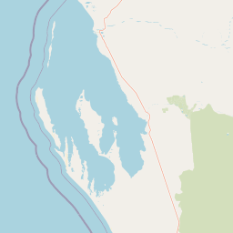
Map view of Pimbee National Park

Use this park location map to pinpoint Pimbee National Park in Australia, understand its exact geographic position, and read its mapped placement within the surrounding landscape more clearly.

Pigeon | © OpenStreetMap contributors

Location context for Pimbee National Park

GascoyneWestern Australia
Park atlas

Compare Protected Areas, Their Landscapes, and Conservation in the Gascoyne Region

Discover Other National Parks Near Pimbee National Park in Western Australia's Arid Landscapes
Explore other national parks and protected areas geographically adjacent to Pimbee National Park, tracing the arid landscapes of Western Australia's Carnarvon xeric shrublands bioregion. This focused view allows for comparing diverse protected-area management models, regional conservation efforts, and shared ecological characteristics across similar semi-desert terrain.
National parkGascoyne

Kennedy Range National Park: Explore Its Dramatic Sandstone Plateau and Canyon Geography

Discover the protected landscapes of Gascoyne's arid terrain.

Kennedy Range National Park is a protected area defined by its striking geological formations, including a vast sandstone plateau and deeply incised canyons that create a dramatic mesa landscape. Situated in the Gascoyne region, this national park serves as a significant example of Australia's inland semi-arid environments, offering rich context for mapped terrain exploration. Understand the park's protected boundaries, its unique arid-zone ecosystems, and the visual contrast it presents within the regional geography, providing valuable insights for atlas-driven discovery.

Area
1,416.6 km²
Established
1993
IUCN
II
Relief
Highland
National parkWestern Australia

Mount Augustus National Park: Western Australia National Park & Protected Landscape

Explore its mapped terrain and regional geographic context.

Mount Augustus National Park represents a significant protected area within the diverse geography of Western Australia. This page serves as a portal to understanding its specific protected landscape characteristics and its contribution to the state's mapped natural areas. Users can explore the park's geographic identity, its defined boundaries, and its role within a broader atlas of protected lands, providing essential context for regional landscape discovery.

Area
91.68 km²
Established
1989
IUCN
III
Relief
Mountain
National parkWestern Australia

Kalbarri National Park: Discover Its Mapped Geography and Protected Landscape Identity

Western Australia's protected national park terrain.

Kalbarri National Park is a vital protected area within the vast geography of Western Australia. This detail entry provides essential context for understanding the park's specific protected landscape, its geographic features, and how it integrates into the broader regional atlas. Explore the mapped boundaries and natural terrain that define Kalbarri National Park, offering a foundation for deeper geographic study and protected-area discovery.

Area
1,830.05 km²
Established
1963
IUCN
II
Relief
Mixed relief
National parkAustralia

Cape Range (South) National Park: Exploring Australia's Arid Semiarid Landscape Atlas

Mapped protected boundaries and regional terrain in Western Australia.

Cape Range (South) National Park, situated in Western Australia, is a vital protected area safeguarding a significant portion of the Carnarvon xeric shrublands. This national park offers a glimpse into a unique arid-zone landscape defined by low ranges, sandy plains, and characteristic acacia shrubland. Its establishment extends conservation efforts in the Gascoyne region, providing crucial context for mapped geography and the distribution of arid-adapted ecosystems within Australia's broader atlas.

Area
270.72 km²
Established
2020
IUCN
II
Relief
Upland
National parkAustralia

Houtman Abrolhos Islands National Park: Australia's Mapped Protected Landscape

Essential geography and park boundary details for this protected area.

Investigate Houtman Abrolhos Islands National Park, a significant protected area offering a unique lens into Australia's diverse geography. This national park's mapped boundaries and specific landscape features provide valuable context for understanding protected lands and regional terrain. Explore the distinct geographic character of this protected region, contributing to a richer comprehension of Australia's atlas of natural landscapes.

Area
15.64 km²
Established
2019
Relief
Lowland
Access
Moderate access
National parkWestern Australia

Lakeside National Park: Protected Landscape in Western Australia's Murchison Bioregion

Explore its semi-arid terrain and mapped park boundaries.

Lakeside National Park is an 8,490-hectare national park located in Western Australia's Mid West region, declared in 2021. Situated within the Murchison bioregion, it encompasses characteristic semi-arid landscapes, including Mulga woodland and open plains. This protected area serves as a key site for understanding the geological heritage and ecological communities of inland Western Australia, offering a specific point for mapped landscape exploration.

Area
84.9 km²
Established
2021
IUCN
II
Climate
Arid
Watercolor illustration showing a coastal scene with shoreline, water, and landforms
National parkWestern Australia

Cape Range National Park: Exploring Western Australia's Protected Landscape Identity

Mapped boundaries and regional geographic context.

Cape Range National Park is a vital protected area located in Western Australia, offering a distinct geographic profile for atlas exploration. This entry focuses on its identity as a national park, detailing its mapped landscape and regional context. Users can discover the park's place within the state's diverse terrain and understand its significance as a mapped conservation area, contributing to a structured understanding of Australia's protected lands.

Area
476.55 km²
Established
1965
IUCN
II
Relief
Highland
National parkMid West

Mungada Ridge National Park: National Park Geography and Protected Landscape Details

Mapped boundaries and regional landscape context.

Delve into the protected landscape identity of Mungada Ridge National Park, a significant national park located in Australia's Mid West. This resource provides detailed information on its geographic positioning, mapped boundaries, and the natural terrain it encompasses, contributing to a structured understanding of protected areas within the region and the broader national atlas.

Area
10.31 km²
Established
2022
Relief
Upland
Climate
Arid

Common questions about visiting, size, designation, and location context for Pimbee National Park

Pimbee National Park FAQs for park facts, access, geography, and protected area context
Find quick answers about Pimbee National Park, including protected-area facts, park geography, trail and visitor context, and how the park fits into its surrounding country and regional landscape.
MoriAtlas Explorer

Continue Your Protected Areas Search Across the Global Atlas

Deepen your exploration by continuing the structured search for national parks and protected areas worldwide. Utilize the comprehensive filtering capabilities to compare different conservation landscapes and refine your understanding of global park geography. Discover more about the distribution and characteristics of protected natural areas.

Global natural geography