

Mori Atlas logo
National parkHoutman Abrolhos Islands National Park

Explore mapped boundaries and regional geographic context for this significant national park.

Houtman Abrolhos Islands National Park: Discover Australia's Coastal Protected Landscape

Houtman Abrolhos Islands National Park represents a distinct protected landscape within Australia's broader geographic atlas. This national park offers a unique opportunity to explore its mapped boundaries and understand its place within the natural terrain. Delve into the specific geographic identity of this protected area and uncover its role as a key component of Australia's natural heritage, providing rich context for landscape and atlas exploration.

islandscoral reefsseabird coloniesmarine parkWestern AustraliaMid West

Houtman Abrolhos Islands National Park

National park

Park overview

Structured park overview, official facts, and landscape profile for Houtman Abrolhos Islands National Park

Houtman Abrolhos Islands National Park park facts, protected area profile, and essential visitor context
Review the core facts for Houtman Abrolhos Islands National Park, including designation, size, terrain, visitor scale, habitats, and operating context in one park-focused overview.

About Houtman Abrolhos Islands National Park

Houtman Abrolhos Islands National Park represents one of Western Australia's most significant recent additions to the national park estate, protecting an island chain of remarkable ecological and historical value. The archipelago sits isolated in the Indian Ocean, far enough from the mainland to develop distinctive island ecosystems while remaining close enough to maintain ecological connectivity with the Geraldton Sandplains bioregion. The park's establishment in 2019 marked a watershed moment for marine and island conservation in the state, providing formal protection status to environments that had previously existed in a less certain conservation framework. Visitors arriving at the islands encounter a landscape dominated by low-lying coral limestone and sand formations, with vegetation adapted to the harsh maritime environment including samphire flats, salt-tolerant grasses, and scattered low shrubs. The marine component of the park extends across surrounding waters, encompassing critical habitat for fish, invertebrates, and marine mammals that utilise the reef systems and open waters around the islands.

Quick facts and research context for Houtman Abrolhos Islands National Park

The national park covers 1,564 hectares across the Houtman Abrolhos archipelago, a chain of over 200 islands spanning roughly 100 kilometres along the coast. The park is administered by Western Australia's Department of Biodiversity, Conservation and Attractions and falls within the Geraldton Sandplains bioregion. The islands areday-use only, with camping prohibited to protect sensitive breeding habitats. The declaration in 2019 represented the culmination of years of conservation advocacy and followed a 2017 government announcement committing A$10 million toward initial tourism infrastructure development.

Park context

Deeper park guide and search-rich context for Houtman Abrolhos Islands National Park

Houtman Abrolhos Islands National Park history, landscape, wildlife, and travel context
Explore Houtman Abrolhos Islands National Park through its history, landscape character, ecosystems, wildlife, conservation priorities, cultural context, and seasonal travel timing in a structured park guide built for atlas discovery and search intent.

Why Houtman Abrolhos Islands National Park stands out

The Houtman Abrolhos Islands are best known for their extraordinary seabird colonies, which rank among the most significant breeding populations on Australia's western coast. The islands support substantial colonies of seabirds including various tern species, gulls, and pelicans, making them a focal point for ornithological study and birdwatching interest. The marine environment surrounding the islands is equally notable, featuring coral reef systems that represent the southernmost extensions of tropical coral communities in the eastern Indian Ocean. The archipelago also holds historical significance as the site of numerous shipwreck incidents, most famously the Dutch vessel Batavia, whose wreckage near the Wallabi Group spawned one of the early colonial era's most infamous survival stories.

Houtman Abrolhos Islands National Park history and protected-area timeline

The Houtman Abrolhos Islands were first charted by Dutch navigator Frederik de Houtman in 1619 during an expedition along Australia's unknown western coast, giving the archipelago its name derived from the Dutch word for 'forgotten' or 'neglected.' The 400th anniversary of this first European contact in 2019 provided the symbolic timing for the national park's official declaration, creating a meaningful connection between the islands' natural heritage and their human history. The decades leading to formal protection saw growing recognition of the islands' ecological significance, particularly regarding their seabird breeding colonies and the unique coral reef environments. The Western Australian Government's 2017 announcement committing A$10 million toward park development reflected both conservation commitment and aspirations for sustainable tourism, acknowledging that the islands could support visitor experiences while maintaining environmental integrity. The transition to national park status provided clearer regulatory framework for managing the multiple values of the archipelago, including its biodiversity, landscapes, and historical sites.

Houtman Abrolhos Islands National Park landscape and geographic character

The Houtman Abrolhos presents a distinctive island landscape characterised by coral limestone foundations, extensive sand flats, and minimal relief across most islands. The three island groups display subtle variations in their physical character, with the Wallabi Group featuring larger islands with more developed vegetation communities, while the Easter and Pelsaert Groups include numerous smaller islets and sand cays. Coastal features include beach formations, rocky shores where coral limestone meets the sea, and shallow lagoon areas between islands. The surrounding marine environment features reef platforms extending from island shores, creating complex underwater topography with coral bommies, sand channels, and seagrass beds. Above water, the visual impression is one of vast oceanic emptiness punctuated by low green islands against the endless blue of the Indian Ocean, with the mainland coastline visible on particularly clear days as a distant hazy line.

Houtman Abrolhos Islands National Park ecosystems, habitats, and plant life

The ecological character of Houtman Abrolhos Islands National Park reflects the convergence of tropical and temperate marine influences at this latitude, creating unusual species assemblages that draw from both biogeographic realms. The surrounding waters support coral reef communities that represent the southern limit of many tropical coral species, making the reef systems significant for understanding climate-driven distribution patterns. The islands contain limited but distinctive terrestrial vegetation, with plant communities adapted to salt-laden winds, limited fresh water, and the challenges of island isolation. Intertidal zones around the islands host diverse invertebrate communities, while the surrounding waters support fish populations that attract both commercial and recreational fishing interest, though these activities occur within managed frameworks.

Houtman Abrolhos Islands National Park wildlife and species highlights

Seabird colonies constitute the most visible wildlife presence in the national park, with the islands providing crucial breeding habitat for species that exploit the productive marine waters surrounding the archipelago. Terns of several species nest in dense colonies on appropriate islands, with their noisy breeding activities creating a characteristic soundscape during the peak breeding season. Sooty Oystercatchers and other shorebirds utilise beach and intertidal areas, while seabirds including frigatebirds and boobies may be observed soaring over the islands or resting on exposed perches. The marine environment hosts dolphins and occasional whale species during migration seasons, while sea turtles have been recorded in the waters around the islands. The terrestrial wildlife component is more limited given the small island sizes and harsh environmental conditions, but includes reptiles adapted to island life and invertebrates specific to island habitats.

Houtman Abrolhos Islands National Park conservation status and protection priorities

The declaration of Houtman Abrolhos Islands National Park in 2019 filled a significant gap in Western Australia's protected area network, providing formal conservation recognition to island ecosystems that had lacked this level of protection. The national park status acknowledges the islands' significance as breeding grounds for seabird populations that depend on secure, predator-free locations for successful reproduction. The prohibition on camping reflects a management philosophy prioritising minimal disturbance to these sensitive breeding areas, recognising that even low-intensity activities can have cumulative impacts on island ecosystems. The reef systems surrounding the islands represent conservation priorities given their scientific value as the southernmost extent of certain coral communities, making them important reference points for understanding reef responses to changing ocean conditions.

Houtman Abrolhos Islands National Park cultural meaning and human context

The Houtman Abrolhos Islands carry deep historical significance stemming from their position as one of the first points of contact between European explorers and Australia's western coast. The 1619 Dutch sighting marked the beginning of a period during which the islands became notorious as a shipwreck hazard, most famously during the Batavia disaster of 1629 when the VOC ship foundered near the Wallabi Group. The subsequent castaway narrative involving survival, murder, and eventual rescue has become embedded in Australian colonial history. While the islands' indigenous heritage is less prominently documented in available sources, the traditional owners maintain connection to these coastal and island landscapes. The 2019 national park declaration created a framework that could potentially support acknowledgment of both natural and cultural heritage values.

Top sights and standout views in Houtman Abrolhos Islands National Park

The Houtman Abrolhos Islands offer visitors an experience of remote island wilderness accessible from the Geraldton coast, with the journey across open water contributing to the sense of discovery that characterises the destination. Birdwatching opportunities rank among the most compelling reasons to visit, with the chance to observe dense seabird colonies and appreciate the spectacle of breeding activity in a relatively accessible setting. The surrounding marine environment supports snorkelling and diving activities, allowing visitors to explore coral reef communities that would otherwise require travel to much more distant tropical locations. The historical dimension of the islands, from early Dutch contact through the Batavia story, adds a cultural layer that distinguishes this marine park from more purely natural destinations.

Best time to visit Houtman Abrolhos Islands National Park

The optimal period for visiting Houtman Abrolhos Islands National Park generally aligns with Western Australia's warmer months, from late spring through early autumn, when sea conditions tend to be more stable and weather patterns more predictable. The summer period typically offers calm seas suitable for the ferry crossing from Geraldton, though afternoon sea breezes can occasionally create choppy conditions. Wildlife viewing opportunities remain consistent throughout the year, though seabird breeding cycles influence the character of bird observations, with different species nesting at different times. Winter visits may offer cooler conditions but potentially more variable weather and sea states that could affect access.
Park location guide

Geography guide, regional context, and park location map for Houtman Abrolhos Islands National Park

Houtman Abrolhos Islands National Park park geography, regions, and map view in Australia
Understand where Houtman Abrolhos Islands National Park sits in Australia through a broader geographic reading of the surrounding landscape, nearby location context, and its mapped position within the national park landscape.

How Houtman Abrolhos Islands National Park fits into Australia

Australia is a constitutional monarchy and federal parliamentary democracy comprising six states and ten territories. With a population of nearly 28 million, it is one of the world's most urbanised countries, with most people concentrated on the eastern seaboard. The country has a high Human Development Index and is known for its cultural diversity, ancient Aboriginal heritage, and unique wildlife.

Wider geography shaping Houtman Abrolhos Islands National Park in Australia

Australia occupies the entire Australian continent, the island of Tasmania, and numerous smaller islands. It is the world's flattest and driest inhabited continent, featuring vast deserts in the interior (the Outback), tropical rainforests along the eastern coast, and a coastline bordering the Indian and Pacific Oceans.

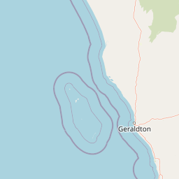
Map view of Houtman Abrolhos Islands National Park

Use this park location map to pinpoint Houtman Abrolhos Islands National Park in Australia, understand its exact geographic position, and read its mapped placement within the surrounding landscape more clearly.

Pigeon | © OpenStreetMap contributors

Location context for Houtman Abrolhos Islands National Park

Mid WestWestern Australia
Park atlas

Trace the geographic spread of coastal protected areas and island ecosystems in Western Australia's Mid West, extending from Geraldton's offshore marine zones.

Discover Nearby Protected Areas: Houtman Abrolhos Islands National Park and Surrounding Marine Landscapes
Continue your exploration beyond Houtman Abrolhos Islands National Park by browsing other national parks and protected areas across Western Australia's Mid West region. Compare these diverse marine and coastal conservation landscapes to understand their interconnected geography, ecological significance, and unique protected features.
National parkWestern Australia

Kalbarri National Park: Discover Its Mapped Geography and Protected Landscape Identity

Western Australia's protected national park terrain.

Kalbarri National Park is a vital protected area within the vast geography of Western Australia. This detail entry provides essential context for understanding the park's specific protected landscape, its geographic features, and how it integrates into the broader regional atlas. Explore the mapped boundaries and natural terrain that define Kalbarri National Park, offering a foundation for deeper geographic study and protected-area discovery.

Area
1,830.05 km²
Established
1963
IUCN
II
Relief
Mixed relief
National parkWestern Australia

Tathra National Park: Protected Landscape Identity and Mapped Geographic Boundaries

Western Australia national park exploration and regional context.

Delve into the protected landscape of Tathra National Park, a significant entity within Western Australia's network of natural areas. This detail provides a structured overview of its geographic position, mapped outlines, and ecological context, serving as a vital entry point for understanding Australia's diverse protected lands and regional geography.

Area
43.22 km²
Established
1970
IUCN
II
Relief
Upland
National parkWestern Australia

Lesueur National Park: Detailed National Park Atlas and Geographic Context

Explore the mapped protected landscape in Western Australia.

Lesueur National Park is a key protected area within the expansive geography of Western Australia. This resource provides detailed information on its national park status, mapped boundaries, and its significance within the regional atlas. Engage with the specific landscape identity of this protected territory and understand its role in the broader geographic context of Australia.

Area
272.35 km²
Established
1992
IUCN
II
Relief
Upland
National parkWestern Australia

Drovers Cave National Park: Protected National Park Landscape in Western Australia

Discover the mapped geography and natural context of this park.

Drovers Cave National Park stands as a key protected area within the expansive Western Australian region. This national park offers a focused lens through which to explore its specific geographic identity and landscape characteristics. As a designated national park, it is mapped within the larger atlas of Australia's protected lands, providing users with structured insights into its regional setting and natural terrain.

Area
26.81 km²
Established
1972
IUCN
II
Relief
Lowland
National parkWestern Australia

Alexander Morrison National Park: Discover Its Protected Landscape and Regional Geography

Mapped protected area boundaries and landscape context in Western Australia.

Alexander Morrison National Park represents a core protected natural landscape within Western Australia. As a national park, its identity is deeply tied to its mapped geographic extent and its role in the regional atlas. This destination provides a focused lens on a specific protected area, enabling users to understand its unique landscape features and its contribution to the conservation estate of Western Australia. Delve into its protected status and geographic orientation within Australia's largest state.

Area
85 km²
Established
1970
IUCN
II
Relief
Upland
Watercolor illustration of a landscape with green rolling hills and pink clouds
National parkWestern Australia

Nambul National Park: A Protected Landscape Within Western Australia's Geographic Context

Explore mapped boundaries and regional terrain context.

Nambul National Park represents a distinct protected area within the expansive geography of Western Australia. This detailed park page offers users an atlas-driven exploration of its identity as a national park, highlighting its mapped natural landscape and its regional significance. Understand the specific geographic features and protected land context that define Nambul National Park within Australia's largest state, fostering deeper geographic discovery.

Area
192.68 km²
Established
1994
IUCN
II
Relief
Upland
National parkWestern Australia

Badgingarra National Park: Mapped Boundaries and Protected Landscape Exploration

Explore its national park designation and regional geography.

Delve into the protected landscape identity of Badgingarra National Park, a designated national park situated in Western Australia. This entry provides detailed atlas-level information, focusing on the park's geographic scope, mapped boundaries, and its significance as a protected natural area. Understand its terrain and regional context for a deeper appreciation of Western Australia's conservation landscapes.

Area
131.08 km²
Established
1973
IUCN
II
Relief
Mixed relief
National parkWestern Australia

Watheroo National Park National Park: Mapping Protected Landscapes in Western Australia

Explore regional geography and mapped park boundaries.

Watheroo National Park represents a key protected landscape within the vast state of Western Australia. This detail page offers focused insight into the park's specific geographic character, its mapped boundaries, and its role within the regional atlas of protected areas. Understand the natural terrain and landscape context that defines this Australian national park.

Area
444.81 km²
Established
1969
IUCN
II
Relief
Upland

Common questions about visiting, size, designation, and location context for Houtman Abrolhos Islands National Park

Houtman Abrolhos Islands National Park FAQs for park facts, access, geography, and protected area context
Find quick answers about Houtman Abrolhos Islands National Park, including protected-area facts, park geography, trail and visitor context, and how the park fits into its surrounding country and regional landscape.
MoriAtlas Explorer

Continue Your Protected Areas Search Across the Global Atlas

Deepen your exploration by continuing the structured search for national parks and protected areas worldwide. Utilize the comprehensive filtering capabilities to compare different conservation landscapes and refine your understanding of global park geography. Discover more about the distribution and characteristics of protected natural areas.

Global natural geography