Mori Atlas logo
National parkNambul National Park

Explore the mapped boundaries and regional terrain of this significant national park.

Nambul National Park: Western Australia's Protected Landscape and Geographic Atlas

Nambul National Park stands as a key protected area within the vast geographic expanse of Western Australia. This atlas-focused entry provides critical context for understanding its role as a national park, detailing its mapped boundaries and situating it within the diverse landscapes of Australia's largest state. Delve into the park's specific geographic identity and its place in the broader regional context.

Limestone formationsDesert landscapesGeological heritageCoastal parksWestern AustraliaThrombolites
Illustration showing limestone pillars in a desert landscape with sandy dunes, sparse vegetation, and a pastel-colored sky

Nambul National Park

National park

Park overview

Structured park overview, official facts, and landscape profile for Nambul National Park

Nambul National Park park facts, protected area profile, and essential visitor context
Review the core facts for Nambul National Park, including designation, size, terrain, visitor scale, habitats, and operating context in one park-focused overview.

About Nambul National Park

Nambul National Park occupies a remarkable position in Western Australia's diverse landscape portfolio, bridging the gap between coastal and inland environments in the state's Wheatbelt region. The park's most famous feature, the Pinnacles Desert, presents visitors with an otherworldly landscape where thousands of limestone formations emerge from golden sands, creating shadows and patterns that change throughout the day. These formations represent a complex geological story spanning millions of years, beginning when this area lay beneath shallow seas teeming with coral and molluscs whose calcified remains accumulated to form limestone beds. Subsequent weathering and erosion have sculpted these beds into the diverse array of pillar shapes visible today, including tall columnar forms, mushroom-shaped capped formations, and smaller, more weathered remnants. The park extends beyond the pinnacles to include coastal landscapes along the Indian Ocean, with beaches at Kangaroo Point and Hangover Bay offering different experiences from the desert interior. The Pinnacles Desert Discovery Centre provides visitors with educational context about the geological processes that created the pinnacles and the cultural and natural values of the area.

Quick facts and research context for Nambul National Park

Nambul National Park covers 192.68 square kilometres in Western Australia's Wheatbelt region. It was established on July 1, 1994, through the combination of three separate reserves gazetted between 1956 and 1968. The park is managed by the Department of Biodiversity, Conservation and Attractions. Its defining feature is the Pinnacles Desert, containing thousands of limestone formations created from deposited marine organisms. The park supports 176 documented animal species including western grey kangaroos, dingos, honey possums, and migratory humpback whales. The Yued people are the traditional custodians of the land.

Park context

Deeper park guide and search-rich context for Nambul National Park

Nambul National Park history, landscape, wildlife, and travel context
Explore Nambul National Park through its history, landscape character, ecosystems, wildlife, conservation priorities, cultural context, and seasonal travel timing in a structured park guide built for atlas discovery and search intent.

Why Nambul National Park stands out

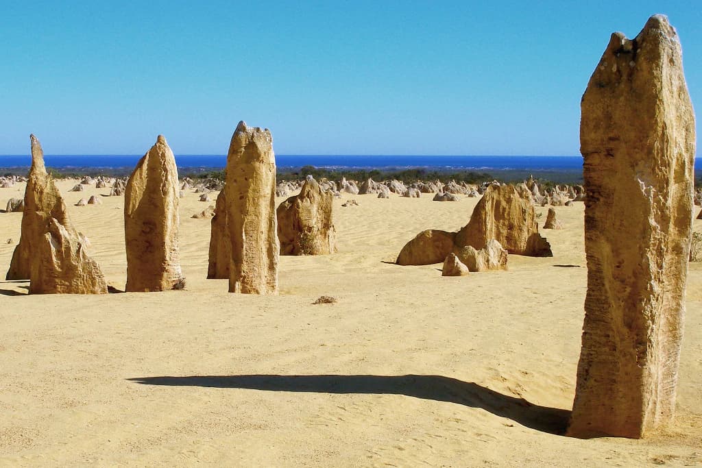
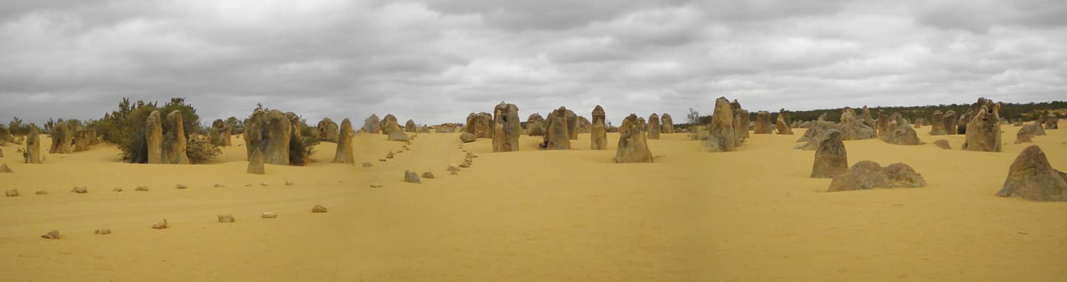
Nambul National Park is best known for the Pinnacles Desert, one of Australia's most distinctive and photographed geological wonders. The thousands of limestone pillars that dot the desert landscape create an almost prehistoric, moonscape appearance that draws visitors from around the world. These formations vary dramatically in shape and size, from tall columns resembling ancient spires to short, tombstone-like structures. The park is also notable for Lake Thetis, home to living thrombolites that represent some of Earth's oldest life forms, with fossilized examples dating back 3.6 billion years. The combination of these two extraordinary geological features within a single protected area makes Nambul uniquely significant in Australian natural heritage.

Limestone pillars in a sandy desert landscape with the Indian Ocean on the horizon under a clear blue sky
Limestone pillar formations of the Pinnacles Desert with the Indian Ocean visible in the background under a clear blue sky

Nambul National Park history and protected-area timeline

European awareness of the Nambul area began in 1658 when Dutch cartographers recorded North and South Hummocks on their maps, providing early documentation of landmark features in the region. Phillip Parker King later mentioned these Hummocks in his journals during the early 1820s as European exploration of Australia's western coast continued. The Pinnacles Desert area itself remained relatively unknown and unstudied until a formal survey was conducted in 1934, bringing scientific attention to these remarkable formations. The park's establishment came in July 1994 when three previously separate reserve areas were combined into a single protected national park. These component reserves had been gazetted at different times: one in 1956 covering the broader area, another in 1967 specifically protecting the Pinnacles, and a third in 1968. The park's name derives from an indigenous Australian word, possibly meaning crooked or winding, which was applied to the Nambut River in 1938. The river flows into the park before disappearing into an underground cave system within the limestone geology.

Nambul National Park landscape and geographic character

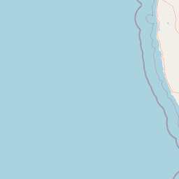
Nambul National Park presents a dramatic contrast between its coastal and desert landscapes. The Pinnacles Desert forms the park's central icon, where thousands of limestone pillars rise from yellow sand in formations that create an almost prehistoric atmosphere. The pillars vary considerably in height, with some reaching up to 3.5 metres above the sand base, while others are only around one metre tall. The formations display several distinct types, including tall, narrow columns that inspired the name Pinnacles, wider tombstone-like shapes, and distinctive mushroom formations where harder calcrete caps have resisted erosion while softer underlying limestone has weathered away. Cross-bedding structures visible in many pillars record changes in wind patterns during the original limestone deposition. Beyond the pinnacles, the park encompasses coastal dune systems along the Indian Ocean, with relatively flat terrain giving way to sandy beaches at Kangaroo Point and Hangover Bay. The park is bordered to the north by the Southern Beekeeper's Nature Reserve and to the south by Wanagarren Nature Reserve, while the Indian Ocean defines its western boundary.

Panoramic view of a desert landscape with numerous limestone pillars under a cloudy sky
Limestone pillars in a desert landscape at Nambul National Park

Nambul National Park ecosystems, habitats, and plant life

The ecological character of Nambul National Park encompasses diverse habitats ranging from coastal heathland through to the unique desert environment of the Pinnacles. The park supports more than 170 documented angiosperm plant species adapted to the region's Mediterranean climate and sandy soils. Typical flora includes coastal wattle, acorn banksia, cowslip orchid, and coast hop-bush, with the only recorded gymnosperm being the swamp cypress. Low heathland areas feature flowering plants that bring seasonal color to the landscape, particularly during spring months. At Lake Thetis, the park contains thrombolite structures that represent living examples of some of Earth's most ancient life forms. These calcareous mounds, built by cyanobacteria, are similar to the better-known stromatolites but differ in their internal structure. Some fossilized examples in the park have been dated to 3.6 billion years old, providing tangible evidence of life's extraordinary history on Earth.

Nambul National Park wildlife and species highlights

Nambul National Park supports a surprising diversity of wildlife despite its seemingly harsh environment, with 176 documented animal species recorded within its boundaries. Mammal inhabitants include western grey kangaroos and red kangaroos that are commonly observed at dawn and dusk, while the park is also home to the tiny honey possum, one of Australia's smallest marsupials. Dingoes roam the park as apex predators, and the introduced red fox is also present. The bird population is particularly diverse, with 128 species documented including silver gulls, black-faced woodswallows, white-backed swallows, red-capped plovers, and Australian ravens. Reptile species include Buchanan's snake-eyed skink, yellow-faced whip snake, the bobtail or blue-tongued skink, and sand goanna. One amphibian species, the sign-bearing froglet, has been recorded in the park. The adjacent Indian Ocean waters host marine wildlife including humpback whales during their northern and southern migration seasons, while sea lions and dolphins are present year-round.

Nambul National Park conservation status and protection priorities

Nambul National Park represents significant conservation value in Western Australia's protected area network, preserving both extraordinary geological heritage and important ecological communities. The Pinnacles Desert formation is unique in Australia and internationally, making the park a significant site for geological conservation. Lake Thetis and its thrombolite communities represent living records of some of Earth's earliest life forms, providing ongoing scientific research opportunities into primordial life processes. The park's coastal and heathland habitats support biodiversity in a region that has experienced extensive agricultural modification, making protected areas like Nambul increasingly important for wildlife conservation. The combination of geological, ecological, and indigenous cultural values within a single protected landscape creates conservation significance that extends beyond individual species or habitats to encompass broader landscape-level preservation.

Nambul National Park cultural meaning and human context

The Yued people are acknowledged as the traditional custodians of the land on which Nambul National Park sits, maintaining connections to this landscape since long before European arrival. The park's name derives from an indigenous Australian word, possibly meaning crooked or winding, which was applied to the Nambut River in 1938. This river flows into the park and disappears into a cave system within the limestone, representing the kind of intimate landscape knowledge that Indigenous Australian peoples hold. The area's cultural significance extends beyond the named geographical features to encompass the broader spiritual and practical relationships between Aboriginal peoples and the coastal and desert environments. The Pinnacles Desert Discovery Centre at the park acknowledges both the natural and cultural heritage values of the area, recognizing that this landscape holds meaning for both its geological and human history.

Top sights and standout views in Nambul National Park

The Pinnacles Desert stands as the absolute highlight of Nambul National Park, offering visitors an unforgettable landscape of thousands of limestone formations rising eerily from golden sand. Lake Thetis provides a completely different experience where visitors can walk along a boardwalk to observe living thrombolites, structures built by micro-organisms that represent some of the oldest life forms on Earth. The coastal sections of the park at Kangaroo Point and Hangover Bay offer beach experiences contrasting sharply with the desert interior, while the pinnacles themselves provide particularly dramatic photography opportunities during sunrise and sunset when shadows elongate across the formations. The Pinnacles Desert Discovery Centre offers interpretive context that enriches understanding of both the geological processes and cultural significance of the area.

Best time to visit Nambul National Park

Nambul National Park can be visited year-round, though certain seasons offer distinct advantages for different experiences. The cooler months from April to October generally provide more comfortable conditions for exploring the park, particularly the desert areas where summer temperatures can become extreme. Spring months bring flowering to the heathland areas, adding color to the landscape beyond the pinnacles. The Pinnacles Desert is visually striking at any time of day, though early morning and late afternoon visits offer dramatic lighting and the opportunity to see wildlife like kangaroos that are more active during cooler parts of the day. Humpback whales can be observed from the coastal areas during their migration seasons, typically from May to November as they move between Antarctic feeding grounds and northern breeding waters.

Park location guide

Geography guide, regional context, and park location map for Nambul National Park

Nambul National Park park geography, regions, and map view in Australia
Understand where Nambul National Park sits in Australia through a broader geographic reading of the surrounding landscape, nearby location context, and its mapped position within the national park landscape.

How Nambul National Park fits into Australia

Australia is a constitutional monarchy and federal parliamentary democracy comprising six states and ten territories. With a population of nearly 28 million, it is one of the world's most urbanised countries, with most people concentrated on the eastern seaboard. The country has a high Human Development Index and is known for its cultural diversity, ancient Aboriginal heritage, and unique wildlife.

Wider geography shaping Nambul National Park in Australia

Australia occupies the entire Australian continent, the island of Tasmania, and numerous smaller islands. It is the world's flattest and driest inhabited continent, featuring vast deserts in the interior (the Outback), tropical rainforests along the eastern coast, and a coastline bordering the Indian and Pacific Oceans.

Map view of Nambul National Park

Use this park location map to pinpoint Nambul National Park in Australia, understand its exact geographic position, and read its mapped placement within the surrounding landscape more clearly.

Pigeon | © OpenStreetMap contributors

Location context for Nambul National Park

Western Australia

Visual Atlas of Nambul National Park: Terrain, Habitats, and Protected-Area Character Through Detailed Imagery

Discover Nambul National Park Photos: Explore Pinnacles Desert Landscapes and Coastal Scenery
Visually explore the striking landscapes of Nambul National Park, understanding its iconic Pinnacles Desert, coastal dunes, and significant Lake Thetis through comprehensive imagery. These photographs reveal the park's diverse terrain, unique habitats, and protected-area character, offering essential context for deep atlas-style discovery of this remarkable Australian conservation area.

Limestone pillars in a sandy desert landscape with the Indian Ocean on the horizon under a clear blue sky

Desert landscape with tall limestone pillars under an orange sky at sunset

Panoramic view of a desert landscape with numerous limestone pillars under a cloudy sky

Park atlas

Trace the regional spread of protected areas in Western Australia, offering context beyond the Pinnacles Desert.

Compare National Parks and Protected Areas Beyond Nambul National Park's Unique Landscapes
Explore a curated selection of other national parks and protected areas located in the region surrounding Nambul National Park. This geographic overview helps you compare diverse landscapes and conservation efforts across Western Australia, providing valuable context for your park discovery.
National parkWestern Australia

Badgingarra National Park: Mapped Boundaries and Protected Landscape Exploration

Explore its national park designation and regional geography.

Delve into the protected landscape identity of Badgingarra National Park, a designated national park situated in Western Australia. This entry provides detailed atlas-level information, focusing on the park's geographic scope, mapped boundaries, and its significance as a protected natural area. Understand its terrain and regional context for a deeper appreciation of Western Australia's conservation landscapes.

Area
131.08 km²
Established
1973
IUCN
II
Relief
Mixed relief
National parkWestern Australia

Drovers Cave National Park: Protected National Park Landscape in Western Australia

Discover the mapped geography and natural context of this park.

Drovers Cave National Park stands as a key protected area within the expansive Western Australian region. This national park offers a focused lens through which to explore its specific geographic identity and landscape characteristics. As a designated national park, it is mapped within the larger atlas of Australia's protected lands, providing users with structured insights into its regional setting and natural terrain.

Area
26.81 km²
Established
1972
IUCN
II
Relief
Lowland
National parkWestern Australia

Lesueur National Park: Detailed National Park Atlas and Geographic Context

Explore the mapped protected landscape in Western Australia.

Lesueur National Park is a key protected area within the expansive geography of Western Australia. This resource provides detailed information on its national park status, mapped boundaries, and its significance within the regional atlas. Engage with the specific landscape identity of this protected territory and understand its role in the broader geographic context of Australia.

Area
272.35 km²
Established
1992
IUCN
II
Relief
Upland
National parkWestern Australia

Alexander Morrison National Park: Discover Its Protected Landscape and Regional Geography

Mapped protected area boundaries and landscape context in Western Australia.

Alexander Morrison National Park represents a core protected natural landscape within Western Australia. As a national park, its identity is deeply tied to its mapped geographic extent and its role in the regional atlas. This destination provides a focused lens on a specific protected area, enabling users to understand its unique landscape features and its contribution to the conservation estate of Western Australia. Delve into its protected status and geographic orientation within Australia's largest state.

Area
85 km²
Established
1970
IUCN
II
Relief
Upland
National parkWestern Australia

Watheroo National Park National Park: Mapping Protected Landscapes in Western Australia

Explore regional geography and mapped park boundaries.

Watheroo National Park represents a key protected landscape within the vast state of Western Australia. This detail page offers focused insight into the park's specific geographic character, its mapped boundaries, and its role within the regional atlas of protected areas. Understand the natural terrain and landscape context that defines this Australian national park.

Area
444.81 km²
Established
1969
IUCN
II
Relief
Upland
National parkWestern Australia

Tathra National Park: Protected Landscape Identity and Mapped Geographic Boundaries

Western Australia national park exploration and regional context.

Delve into the protected landscape of Tathra National Park, a significant entity within Western Australia's network of natural areas. This detail provides a structured overview of its geographic position, mapped outlines, and ecological context, serving as a vital entry point for understanding Australia's diverse protected lands and regional geography.

Area
43.22 km²
Established
1970
IUCN
II
Relief
Upland
National parkWestern Australia

Yanchep National Park: Explore Its Unique Limestone Caves and Protected Bushland Geography

Discover the subterranean formations and coastal plain landscapes.

Yanchep National Park offers a singular opportunity for atlas-driven exploration of Western Australia's natural and cultural heritage. Situated on the Swan Coastal Plain, this national park is celebrated for its extensive network of limestone caves, including the notable Crystal Cave, providing a rare glimpse into subterranean geological processes. Beyond its underground wonders, the park encompasses diverse native bushland, supporting iconic koala colonies and offering insights into the region's ecological distinctiveness. Its deep Nyoongar heritage further enriches the understanding of this mapped protected landscape.

Area
28.76 km²
Established
1957
IUCN
II
Relief
Lowland
National parkWestern Australia

Neerabup National Park: Discover its Protected Landscape and Geographic Identity in Western Australia

Explore mapped boundaries and regional context.

Neerabup National Park represents a crucial protected landscape within Western Australia, offering a distinct geographic identity for atlas-based discovery. This page focuses on its role as a national park, detailing its mapped boundaries and situating it within the rich regional geography of Western Australia. Users can explore the park's unique natural terrain and understand its contribution to the state's protected areas.

Area
9.43 km²
Established
1965
IUCN
II
Relief
Lowland

Common questions about visiting, size, designation, and location context for Nambul National Park

Nambul National Park FAQs for park facts, access, geography, and protected area context
Find quick answers about Nambul National Park, including protected-area facts, park geography, trail and visitor context, and how the park fits into its surrounding country and regional landscape.
MoriAtlas Explorer

Continue Your Protected Areas Search Across the Global Atlas

Deepen your exploration by continuing the structured search for national parks and protected areas worldwide. Utilize the comprehensive filtering capabilities to compare different conservation landscapes and refine your understanding of global park geography. Discover more about the distribution and characteristics of protected natural areas.

Global natural geography