

Mori Atlas logo
National parkTathra National Park

Discover the mapped boundaries and regional landscape character of this Australian national park.

Tathra National Park: Protected Landscape and Geographic Context in Western Australia

Tathra National Park stands as a designated protected area within the expansive geographic landscape of Western Australia. This page offers an atlas-driven exploration of the park's identity, focusing on its mapped boundaries and contribution to the regional natural landscape context. Understand how Tathra National Park fits within the broader geographic tapestry of Western Australia, providing essential insights for any study of protected lands in the region.

National ParkWestern AustraliaHeathlandWildflower ReserveSandplain CountryEndemic Species

Tathra National Park

National park

Park overview

Structured park overview, official facts, and landscape profile for Tathra National Park

Tathra National Park park facts, protected area profile, and essential visitor context
Review the core facts for Tathra National Park, including designation, size, terrain, visitor scale, habitats, and operating context in one park-focused overview.

About Tathra National Park

Tathra National Park represents one of the remaining intact parcels of native vegetation in a landscape that has been extensively cleared for agriculture. The park is situated in the sandplain country of Western Australia's Mid West region, an area characterized by gentle relief and soils derived from ancient sandstone and laterite formations. The terrain within the park transitions from shallow valleys with sandy substrates to laterite-capped slopes and hilltops, creating distinct habitat zones that support varying plant communities. The low heath vegetation changes in composition across this topographic gradient, with different species dominating the valley floors versus the ridgelines. This mosaic of habitats contributes to the park's ecological significance, preserving plant diversity that once characterized the broader region but has since been lost to farming. The park escaped the widespread clearing that transformed the surrounding wheatbelt, providing a living record of the original floral character of this part of Western Australia.

Quick facts and research context for Tathra National Park

Tathra National Park covers 43.22 square kilometres in Western Australia's Mid West region, established in 1970 as an IUCN Category II protected area. The park is managed by the Department of Biodiversity, Conservation and Attractions and is situated between the towns of Eneabba and Carnamah. The landscape consists of sandplain country with shallow valleys featuring sandy floors, transitioning to laterite ridges and hilltops. The vegetation is characterized by low heath communities that vary in composition across different topography. The park is notable for supporting plant species found nowhere else, including a distinctive Daviesia species with large red flowers known only from this reserve.

Park context

Deeper park guide and search-rich context for Tathra National Park

Tathra National Park history, landscape, wildlife, and travel context
Explore Tathra National Park through its history, landscape character, ecosystems, wildlife, conservation priorities, cultural context, and seasonal travel timing in a structured park guide built for atlas discovery and search intent.

Why Tathra National Park stands out

Tathra National Park is best known for its exceptional heathland flora and its role as a conservation refuge for plant species that have disappeared from the surrounding agricultural landscape. The park preserves a representative example of sandplain vegetation communities, featuring unusual plant species including a Daviesia species notable for its large red flowers, which occurs only within this reserve. The shaggy dryandra (Banksia splendida) is also prominent on lateritic rises within the park. The area has historically drawn visitors for wildflower observation during winter and spring months, when the heathland displays its seasonal floral display.

Tathra National Park history and protected-area timeline

The land that now comprises Tathra National Park was set aside for protection by the Department of Lands and Surveys under Reserves 26802 and 26805 on 23 May 1969. During 1970 and 1971, the land underwent classification as an "A" Class reserve, a designation that provides strong legal protection as its purpose cannot be altered except through an Act of Parliament. The reserve was subsequently vested in the National Parks Authority of Western Australia, establishing the institutional framework for its ongoing management. The park was officially named on 8 October 1971, formally establishing its status as a national park. A 1974 report noted that public usage of the park was primarily for wildflower observation during winter and spring months, and recommended that the area be downgraded to a flora and fauna conservation reserve; however, this recommendation was not implemented, and the area retained its national park designation.

Tathra National Park landscape and geographic character

The physical landscape of Tathra National Park reflects the sandplain terrain characteristic of much of the Western Australian wheatbelt region. The park sits on ancient sandplain country characterized by gently undulating topography with shallow valleys and low ridges. The valley floors contain sandy substrates, while the slopes and hilltops feature laterite iron-rich soils that form a hardened cap over the underlying geology. This variation in substrate and soil depth across relatively short distances creates environmental diversity within the park, influencing both drainage patterns and vegetation composition. The surrounding landscape has been extensively cleared for agricultural use, making the park's intact vegetation stands particularly conspicuous against the modified farmland. The heathland vegetation remains relatively low-growing, consistent with the nutrient-poor soils and Mediterranean climate of the region.

Tathra National Park ecosystems, habitats, and plant life

The ecological character of Tathra National Park is defined by its heathland plant communities adapted to the nutrient-poor sandplain soils of the Western Australian wheatbelt. The park preserves a representative sample of the region's original flora, representing vegetation types that have been largely eliminated from surrounding areas through agricultural development. The heath communities vary in composition across different landscape positions, with species assemblages on the sandy valley floors differing from those on the lateritic slopes and ridges. The park supports several plant species of particular conservation significance, including a Daviesia species that is known only from this reserve and represents an endemic element of the local flora. The shaggy dryandra (Banksia splendida) forms a prominent component of the lateritic heath communities, adding to the park's botanical significance.

Tathra National Park wildlife and species highlights

While the Wikipedia source focuses primarily on the park's botanical values, Tathra National Park's intact heathland and woodland habitats support various wildlife species typical of the Western Australian wheatbelt region. The heathland provides habitat for birds and small mammals adapted to scrubland environments. The diverse plant communities, including species that flower in winter and spring, support insect pollinators and provide foraging resources for various fauna. The lateritic ridges and sandy valley floors offer different habitat conditions that may support distinct wildlife assemblages. The park's status as a remnant of original vegetation in a cleared agricultural landscape means it serves as important habitat for species that depend on intact native vegetation communities.

Tathra National Park conservation status and protection priorities

Tathra National Park serves an important conservation function as one of the few remaining examples of intact sandplain vegetation in the Western Australian wheatbelt. The park preserves plant species and communities that have been largely eliminated from the surrounding agricultural landscape through widespread clearing for crop production. Its "A" Class reserve status provides strong legal protection, ensuring the land cannot be diverted to other uses without parliamentary action. The park's representative flora includes species with restricted distributions, such as the endemic Daviesia with its distinctive red flowers. The preservation of this heathland ecosystem maintains genetic diversity and ecological processes that would otherwise be lost from the region. As a remnant of the original vegetation, the park also serves as a reference site for understanding the pre-agricultural character of the Western Australian sandplain country.

Tathra National Park cultural meaning and human context

The name Tathra originates from the Noongar language, the traditional language of the Aboriginal people who inhabited this region of Western Australia. The translation of "beautiful place" reflects an appreciation for the area's environmental qualities that has persisted since before European settlement. The Noongar people have long connections to the lands of the Southwest Australian biodiversity hotspot, and many protected areas in the region hold cultural significance for Traditional Owners. The park sits within the broader Noongar Country, though the Wikipedia source provides limited specific detail about traditional uses or cultural features of the site itself.

Top sights and standout views in Tathra National Park

Tathra National Park offers visitors the opportunity to experience remnants of Western Australia's original sandplain vegetation in a landscape otherwise dominated by agricultural production. The park's botanical highlights include the endemic Daviesia species with large red flowers, visible primarily during the wildflower season, and the striking shaggy dryandra that dominates lateritic ridge areas. The gentle sandplain terrain provides accessible walking opportunities through diverse heathland communities. The park's historical significance as a preserved remnant that escaped early twentieth-century clearing adds depth to the visitor experience, offering insight into the pre-agricultural character of the Mid West region.

Best time to visit Tathra National Park

The optimal time to visit Tathra National Park is during the winter and spring months, from approximately June through November, when the heathland wildflowers are in bloom. This flowering period is when the park's botanical highlights, including the distinctive red flowers of the endemic Daviesia and the flowering Banksia species, are most visually impressive. The cooler months also offer more comfortable conditions for walking and exploring the park's trails. Summer months can be hot and dry, with reduced floral interest, while autumn may offer pleasant weather though with limited flower display. The park can be visited year-round, but those specifically interested in wildflower observation should plan their visit for the mid to late winter period when flowering peaks.

Park location guide

Geography guide, regional context, and park location map for Tathra National Park

Tathra National Park park geography, regions, and map view in Australia
Understand where Tathra National Park sits in Australia through a broader geographic reading of the surrounding landscape, nearby location context, and its mapped position within the national park landscape.

How Tathra National Park fits into Australia

Australia is a constitutional monarchy and federal parliamentary democracy comprising six states and ten territories. With a population of nearly 28 million, it is one of the world's most urbanised countries, with most people concentrated on the eastern seaboard. The country has a high Human Development Index and is known for its cultural diversity, ancient Aboriginal heritage, and unique wildlife.

Wider geography shaping Tathra National Park in Australia

Australia occupies the entire Australian continent, the island of Tasmania, and numerous smaller islands. It is the world's flattest and driest inhabited continent, featuring vast deserts in the interior (the Outback), tropical rainforests along the eastern coast, and a coastline bordering the Indian and Pacific Oceans.

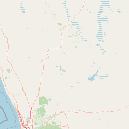
Map view of Tathra National Park

Use this park location map to pinpoint Tathra National Park in Australia, understand its exact geographic position, and read its mapped placement within the surrounding landscape more clearly.

Pigeon | © OpenStreetMap contributors

Location context for Tathra National Park

Western Australia
Park atlas

Compare Western Australian Protected Landscapes and Regional Park Geography Beyond Tathra National Park.

Explore Other National Parks and Protected Areas Near Tathra National Park in Western Australia
Users can browse additional national parks and protected areas across Western Australia's Mid West region, offering diverse sandplain country, heathland, and botanical conservation landscapes for comparison. Continuing your exploration provides valuable regional context, tracing interconnected protected-area geography and showcasing the varied ecological significance of nearby natural reserves.
National parkWestern Australia

Alexander Morrison National Park: Discover Its Protected Landscape and Regional Geography

Mapped protected area boundaries and landscape context in Western Australia.

Alexander Morrison National Park represents a core protected natural landscape within Western Australia. As a national park, its identity is deeply tied to its mapped geographic extent and its role in the regional atlas. This destination provides a focused lens on a specific protected area, enabling users to understand its unique landscape features and its contribution to the conservation estate of Western Australia. Delve into its protected status and geographic orientation within Australia's largest state.

Area
85 km²
Established
1970
IUCN
II
Relief
Upland
National parkWestern Australia

Lesueur National Park: Detailed National Park Atlas and Geographic Context

Explore the mapped protected landscape in Western Australia.

Lesueur National Park is a key protected area within the expansive geography of Western Australia. This resource provides detailed information on its national park status, mapped boundaries, and its significance within the regional atlas. Engage with the specific landscape identity of this protected territory and understand its role in the broader geographic context of Australia.

Area
272.35 km²
Established
1992
IUCN
II
Relief
Upland
National parkWestern Australia

Watheroo National Park National Park: Mapping Protected Landscapes in Western Australia

Explore regional geography and mapped park boundaries.

Watheroo National Park represents a key protected landscape within the vast state of Western Australia. This detail page offers focused insight into the park's specific geographic character, its mapped boundaries, and its role within the regional atlas of protected areas. Understand the natural terrain and landscape context that defines this Australian national park.

Area
444.81 km²
Established
1969
IUCN
II
Relief
Upland
National parkWestern Australia

Drovers Cave National Park: Protected National Park Landscape in Western Australia

Discover the mapped geography and natural context of this park.

Drovers Cave National Park stands as a key protected area within the expansive Western Australian region. This national park offers a focused lens through which to explore its specific geographic identity and landscape characteristics. As a designated national park, it is mapped within the larger atlas of Australia's protected lands, providing users with structured insights into its regional setting and natural terrain.

Area
26.81 km²
Established
1972
IUCN
II
Relief
Lowland
National parkWestern Australia

Badgingarra National Park: Mapped Boundaries and Protected Landscape Exploration

Explore its national park designation and regional geography.

Delve into the protected landscape identity of Badgingarra National Park, a designated national park situated in Western Australia. This entry provides detailed atlas-level information, focusing on the park's geographic scope, mapped boundaries, and its significance as a protected natural area. Understand its terrain and regional context for a deeper appreciation of Western Australia's conservation landscapes.

Area
131.08 km²
Established
1973
IUCN
II
Relief
Mixed relief
Watercolor illustration of a landscape with green rolling hills and pink clouds
National parkWestern Australia

Nambul National Park: A Protected Landscape Within Western Australia's Geographic Context

Explore mapped boundaries and regional terrain context.

Nambul National Park represents a distinct protected area within the expansive geography of Western Australia. This detailed park page offers users an atlas-driven exploration of its identity as a national park, highlighting its mapped natural landscape and its regional significance. Understand the specific geographic features and protected land context that define Nambul National Park within Australia's largest state, fostering deeper geographic discovery.

Area
192.68 km²
Established
1994
IUCN
II
Relief
Upland
National parkMid West

Mungada Ridge National Park: National Park Geography and Protected Landscape Details

Mapped boundaries and regional landscape context.

Delve into the protected landscape identity of Mungada Ridge National Park, a significant national park located in Australia's Mid West. This resource provides detailed information on its geographic positioning, mapped boundaries, and the natural terrain it encompasses, contributing to a structured understanding of protected areas within the region and the broader national atlas.

Area
10.31 km²
Established
2022
Relief
Upland
Climate
Arid
National parkWestern Australia

Yanchep National Park: Explore Its Unique Limestone Caves and Protected Bushland Geography

Discover the subterranean formations and coastal plain landscapes.

Yanchep National Park offers a singular opportunity for atlas-driven exploration of Western Australia's natural and cultural heritage. Situated on the Swan Coastal Plain, this national park is celebrated for its extensive network of limestone caves, including the notable Crystal Cave, providing a rare glimpse into subterranean geological processes. Beyond its underground wonders, the park encompasses diverse native bushland, supporting iconic koala colonies and offering insights into the region's ecological distinctiveness. Its deep Nyoongar heritage further enriches the understanding of this mapped protected landscape.

Area
28.76 km²
Established
1957
IUCN
II
Relief
Lowland

Common questions about visiting, size, designation, and location context for Tathra National Park

Tathra National Park FAQs for park facts, access, geography, and protected area context
Find quick answers about Tathra National Park, including protected-area facts, park geography, trail and visitor context, and how the park fits into its surrounding country and regional landscape.
MoriAtlas Explorer

Continue Your Protected Areas Search Across the Global Atlas

Deepen your exploration by continuing the structured search for national parks and protected areas worldwide. Utilize the comprehensive filtering capabilities to compare different conservation landscapes and refine your understanding of global park geography. Discover more about the distribution and characteristics of protected natural areas.

Global natural geography