

Mori Atlas logo
National parkWatheroo National Park

Explore the mapped boundaries and regional natural terrain of this significant Australian national park.

Watheroo National Park: Protected Landscape and Geographic Context in Western Australia

Watheroo National Park stands as a distinct protected natural area within the expansive geography of Western Australia. This page serves as a gateway to understanding the park's specific protected landscape identity and its integration into the broader regional atlas. Users can explore the mapped boundaries, natural terrain, and the unique geographic context that defines Watheroo National Park, providing a foundation for structured discovery of Australia's protected lands.

National ParkWestern AustraliaSand PlainsHeathlandMalleeWildflowers

Watheroo National Park

National park

Park overview

Structured park overview, official facts, and landscape profile for Watheroo National Park

Watheroo National Park park facts, protected area profile, and essential visitor context
Review the core facts for Watheroo National Park, including designation, size, terrain, visitor scale, habitats, and operating context in one park-focused overview.

About Watheroo National Park

Watheroo National Park represents a significant protected area in Western Australia's Mid West, preserving a distinctive sand plain landscape that might otherwise be consumed by surrounding agricultural development. The park's creation in 1969 established protection for an ecosystem characterized by quartz-based sandy soils, occasional sandstone outcrops, and areas where laterite caps have formed on ancient geological substrates. This terrain creates a unique basin landscape positioned between the Dandaragan plateau to the north and the Darling plateau to the south. The park's vegetation is remarkably diverse, with heath communities dominating much of the interior, mallee eucalyptus forms scattered throughout, and Banksia species providing structural complexity. Eucalypt stands become more concentrated toward the western end of the park, while spinifex, wandoo, and yorm gum add further botanical variety. The park's eastern boundary follows Low Creek, which carries seasonal flows southward to join the Moore River system, providing important hydrological connectivity to the broader regional landscape.

Quick facts and research context for Watheroo National Park

Watheroo National Park occupies 444.81 square kilometers of Western Australia's Mid West region, established in 1969. The park lies roughly 187 kilometers north of Perth, between Badgingarra and Dalwallinu along the Midlands Road. It is managed by the Department of Environment and Conservation and borders Pinjarrega Nature Reserve to the north. The park's terrain consists primarily of sand plain with quartz-rich soils and sandstone exposures, supporting a distinctive heath, mallee, and Banksia ecosystem.

Park context

Deeper park guide and search-rich context for Watheroo National Park

Watheroo National Park history, landscape, wildlife, and travel context
Explore Watheroo National Park through its history, landscape character, ecosystems, wildlife, conservation priorities, cultural context, and seasonal travel timing in a structured park guide built for atlas discovery and search intent.

Why Watheroo National Park stands out

Watheroo National Park is best known for its extensive sand plain ecosystems supporting remarkable biodiversity, including populations of heath, mallee, and Banksia vegetation communities. The park contains Jingemia Cave, a notable geological feature within the region. Its wildflower displays featuring kwongan, bush cauliflower, and scarlet featherflower are particularly significant. The park also sits above the Warro gas field, which has been subject to seismic exploration, adding an industrial dimension to its conservation context.

Watheroo National Park history and protected-area timeline

Watheroo National Park was established in 1969 as a protected area under Western Australian conservation legislation, receiving IUCN Category II designation as a national park. The park's creation reflected growing recognition of the ecological significance of Western Australia's sand plain environments, which had increasingly come under pressure from agricultural expansion. The park's name derives from an Indigenous Australian term referring to a natural spring located near the protected area, and this linguistic heritage connects the modern park to the region's Aboriginal land management history. The adjacent town of Watheroo, situated east of the park boundary, shares this Indigenous name. In 2010, the Environmental Protection Authority of Western Australia approved a proposal to conduct seismic surveying of the Warro gas field located beneath the park, authorizing Latent Petroleum to conduct geological exploration activities. This decision generated discussion regarding the balance between resource development and conservation within protected areas.

Watheroo National Park landscape and geographic character

The physical landscape of Watheroo National Park is defined by its sand plain character and geological setting between two major regional plateaus. The park's underlying geology consists predominantly of quartz-based sandy soils, with visible sandstone outcrops emerging in certain areas and laterite caps forming on elevated sections. This combination creates an undulating terrain that acts as a transitional basin between the Dandaragan plateau to the north and the Darling plateau to the south. The landscape lacks prominent elevation changes but maintains visual interest through its subtle topography and vegetation patterns. Low Creek, which forms the park's eastern boundary, provides a seasonal drainage line that carries water southward to join the Moore River. The park is otherwise surrounded by cleared agricultural farmland, creating a sharp boundary between the protected ecosystem and the modified pastoral landscape.

Watheroo National Park ecosystems, habitats, and plant life

The ecological character of Watheroo National Park centers on a sand plain ecosystem supporting distinctive southwestern Australian vegetation communities. The park's heath formations represent a significant component, characterized by diverse shrub layers adapted to nutrient-poor sandy soils. Mallee eucalyptus forms, with their multi-stemmed growth habit, are interspersed throughout the landscape, while Banksia species provide architectural variety and year-round flowering resources. The western end of the park supports more dense eucalypt stands, representing a different structural formation within the broader park mosaic. Wildflower diversity is a particular highlight, with species such as kwongan, bush cauliflower (Verticordia eriocephala), and scarlet featherflower (Verticordia grandis) adding seasonal color. Spinifex, wandoo, and yorm gum represent additional botanical components that contribute to the park's ecological complexity.

Watheroo National Park wildlife and species highlights

While the source material focuses more heavily on botanical aspects than fauna, Watheroo National Park's wildlife is tied to its sand plain and heath ecosystems. The diverse vegetation communities provide habitat for various bird species and small mammals typical of southwestern Australian woodland and heath environments. The wildflower displays support insect pollinators, while the varied vegetation structure offers shelter and foraging resources for woodland birds. The park's position within the Mid West region places it within a biodiversity hotspot, though specific species documentation in the available source material is limited.

Watheroo National Park conservation status and protection priorities

Watheroo National Park plays an important role in preserving sand plain ecosystems in a region where agricultural conversion has been extensive. The protected area maintains connectivity between the Dandaragan and Darling plateaus and provides refuge for vegetation communities that have been largely eliminated from surrounding lands. The park's designation as IUCN Category II reflects its national significance and the commitment to maintaining its ecological integrity. However, the 2010 approval of seismic surveying for the Warro gas field beneath the park demonstrates ongoing tensions between conservation values and resource extraction interests. The park's proximity to Pinjarrega Nature Reserve to the north creates a larger conservation complex, though the surrounding farmland matrix limits ecological connectivity in other directions.

Watheroo National Park cultural meaning and human context

Watheroo National Park carries cultural significance through its Indigenous Australian naming, derived from the word for a spring located near the protected area. This linguistic heritage connects the modern park to Aboriginal relationships with the landscape and its water sources. The adjacent town of Watheroo, situated to the east of the park, shares this Indigenous name, reflecting the area's pre-colonial human geography. The presence of Jingemia Cave within the park suggests archaeological or cultural significance, though the available source material provides limited detail about this site. The park's landscape has been subject to modification through surrounding agricultural development, though the protected area itself retains its natural character.

Top sights and standout views in Watheroo National Park

Watheroo National Park offers visitors distinctive sand plain landscapes, remarkable wildflower displays in spring, and access to Jingemia Cave. The park's location roughly 187 kilometers north of Perth makes it accessible for day trips from the capital, while its relative remoteness ensures a wilderness character. The contrast between the protected heath and mallee ecosystems and surrounding farmland illustrates the ecological value of establishing conservation reserves in modified landscapes. The park's geological features, including sandstone outcrops and laterite exposures, provide interest for those interested in earth sciences.

Best time to visit Watheroo National Park

The optimal time to visit Watheroo National Park is during Western Australia's spring months (September to November) when wildflower displays are at their peak. The kwongan, bush cauliflower, and scarlet featherflower mentioned in source material bloom during this period, creating colorful spectacles across the sand plain. Autumn and winter bring cooler temperatures and occasional rainfall, which can make the landscape appear more verdant but may limit some access routes. Summer months (December to February) are typically hot and dry, which while possible to visit, may reduce the appeal of extended outdoor exploration. The park can be visited year-round, though spring provides the most visually rewarding experience for nature enthusiasts interested in the region's botanical diversity.
Park location guide

Geography guide, regional context, and park location map for Watheroo National Park

Watheroo National Park park geography, regions, and map view in Australia
Understand where Watheroo National Park sits in Australia through a broader geographic reading of the surrounding landscape, nearby location context, and its mapped position within the national park landscape.

How Watheroo National Park fits into Australia

Australia is a constitutional monarchy and federal parliamentary democracy comprising six states and ten territories. With a population of nearly 28 million, it is one of the world's most urbanised countries, with most people concentrated on the eastern seaboard. The country has a high Human Development Index and is known for its cultural diversity, ancient Aboriginal heritage, and unique wildlife.

Wider geography shaping Watheroo National Park in Australia

Australia occupies the entire Australian continent, the island of Tasmania, and numerous smaller islands. It is the world's flattest and driest inhabited continent, featuring vast deserts in the interior (the Outback), tropical rainforests along the eastern coast, and a coastline bordering the Indian and Pacific Oceans.

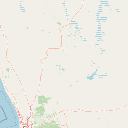
Map view of Watheroo National Park

Use this park location map to pinpoint Watheroo National Park in Australia, understand its exact geographic position, and read its mapped placement within the surrounding landscape more clearly.

Pigeon | © OpenStreetMap contributors

Location context for Watheroo National Park

Western Australia
Park atlas

Map regional protected landscapes and compare park geography near the Mid West region of Western Australia.

Explore Nearby National Parks and Protected Areas Surrounding Watheroo National Park
Continue your exploration from Watheroo National Park by browsing a curated selection of national parks and protected areas across Western Australia's Mid West region. This contextual view allows for geographic comparison of sand plain ecosystems, unique heathlands, and other conservation landscapes surrounding the park.
National parkWestern Australia

Alexander Morrison National Park: Discover Its Protected Landscape and Regional Geography

Mapped protected area boundaries and landscape context in Western Australia.

Alexander Morrison National Park represents a core protected natural landscape within Western Australia. As a national park, its identity is deeply tied to its mapped geographic extent and its role in the regional atlas. This destination provides a focused lens on a specific protected area, enabling users to understand its unique landscape features and its contribution to the conservation estate of Western Australia. Delve into its protected status and geographic orientation within Australia's largest state.

Area
85 km²
Established
1970
IUCN
II
Relief
Upland
National parkWestern Australia

Badgingarra National Park: Mapped Boundaries and Protected Landscape Exploration

Explore its national park designation and regional geography.

Delve into the protected landscape identity of Badgingarra National Park, a designated national park situated in Western Australia. This entry provides detailed atlas-level information, focusing on the park's geographic scope, mapped boundaries, and its significance as a protected natural area. Understand its terrain and regional context for a deeper appreciation of Western Australia's conservation landscapes.

Area
131.08 km²
Established
1973
IUCN
II
Relief
Mixed relief
National parkWestern Australia

Tathra National Park: Protected Landscape Identity and Mapped Geographic Boundaries

Western Australia national park exploration and regional context.

Delve into the protected landscape of Tathra National Park, a significant entity within Western Australia's network of natural areas. This detail provides a structured overview of its geographic position, mapped outlines, and ecological context, serving as a vital entry point for understanding Australia's diverse protected lands and regional geography.

Area
43.22 km²
Established
1970
IUCN
II
Relief
Upland
National parkWestern Australia

Lesueur National Park: Detailed National Park Atlas and Geographic Context

Explore the mapped protected landscape in Western Australia.

Lesueur National Park is a key protected area within the expansive geography of Western Australia. This resource provides detailed information on its national park status, mapped boundaries, and its significance within the regional atlas. Engage with the specific landscape identity of this protected territory and understand its role in the broader geographic context of Australia.

Area
272.35 km²
Established
1992
IUCN
II
Relief
Upland
National parkWestern Australia

Drovers Cave National Park: Protected National Park Landscape in Western Australia

Discover the mapped geography and natural context of this park.

Drovers Cave National Park stands as a key protected area within the expansive Western Australian region. This national park offers a focused lens through which to explore its specific geographic identity and landscape characteristics. As a designated national park, it is mapped within the larger atlas of Australia's protected lands, providing users with structured insights into its regional setting and natural terrain.

Area
26.81 km²
Established
1972
IUCN
II
Relief
Lowland
Watercolor illustration of a landscape with green rolling hills and pink clouds
National parkWestern Australia

Nambul National Park: A Protected Landscape Within Western Australia's Geographic Context

Explore mapped boundaries and regional terrain context.

Nambul National Park represents a distinct protected area within the expansive geography of Western Australia. This detailed park page offers users an atlas-driven exploration of its identity as a national park, highlighting its mapped natural landscape and its regional significance. Understand the specific geographic features and protected land context that define Nambul National Park within Australia's largest state, fostering deeper geographic discovery.

Area
192.68 km²
Established
1994
IUCN
II
Relief
Upland
National parkWestern Australia

Yanchep National Park: Explore Its Unique Limestone Caves and Protected Bushland Geography

Discover the subterranean formations and coastal plain landscapes.

Yanchep National Park offers a singular opportunity for atlas-driven exploration of Western Australia's natural and cultural heritage. Situated on the Swan Coastal Plain, this national park is celebrated for its extensive network of limestone caves, including the notable Crystal Cave, providing a rare glimpse into subterranean geological processes. Beyond its underground wonders, the park encompasses diverse native bushland, supporting iconic koala colonies and offering insights into the region's ecological distinctiveness. Its deep Nyoongar heritage further enriches the understanding of this mapped protected landscape.

Area
28.76 km²
Established
1957
IUCN
II
Relief
Lowland
National parkWestern Australia

Avon Valley National Park: Protected National Park Discovery in Western Australia

Explore mapped boundaries and regional landscape context.

Delve into Avon Valley National Park, a designated national park offering rich opportunities for protected-area and landscape discovery. This page serves as an atlas-style entry point, detailing the park's mapped geography and its role within the diverse natural terrain of Western Australia. Understand its specific protected landscape identity and how it contributes to the broader conservation map.

Area
43.66 km²
Established
1970
IUCN
II
Relief
Mixed relief

Common questions about visiting, size, designation, and location context for Watheroo National Park

Watheroo National Park FAQs for park facts, access, geography, and protected area context
Find quick answers about Watheroo National Park, including protected-area facts, park geography, trail and visitor context, and how the park fits into its surrounding country and regional landscape.
MoriAtlas Explorer

Continue Your Protected Areas Search Across the Global Atlas

Deepen your exploration by continuing the structured search for national parks and protected areas worldwide. Utilize the comprehensive filtering capabilities to compare different conservation landscapes and refine your understanding of global park geography. Discover more about the distribution and characteristics of protected natural areas.

Global natural geography
Watheroo National Park: Western Australia National Park Map & Atlas