

Mori Atlas logo
National parkAvon Valley National Park

Discover mapped boundaries and regional geographic context within this protected natural area.

Avon Valley National Park: Western Australia's Protected National Park Landscape

Avon Valley National Park stands as a significant protected national park entity within the vast geographic expanse of Western Australia. This page provides an atlas-focused view of its protected landscape, detailing its mapped boundaries and offering insights into its natural terrain. Understand its place within the broader regional geography of Western Australia, contributing to a structured exploration of Australia's conserved natural areas.

National ParkWestern AustraliaJarrah WoodlandBirdwatchingWildflowersGranite Outcrops

Avon Valley National Park

National park

Park overview

Structured park overview, official facts, and landscape profile for Avon Valley National Park

Avon Valley National Park park facts, protected area profile, and essential visitor context
Review the core facts for Avon Valley National Park, including designation, size, terrain, visitor scale, habitats, and operating context in one park-focused overview.

About Avon Valley National Park

Avon Valley National Park protects a representative section of the Western Australian wheatbelt's natural heritage, offering visitors an accessible wilderness experience relatively close to Perth. The park's topography centres on the Avon River, which has carved a deep valley through the ancient landscape, creating a mosaic of woodland, riparian and rocky outcrop habitats. The vegetation reflects the transitional nature of the region, where jarrah forest gives way to wandoo woodland on the valley floors and slopes. Visitors can explore walking trails that wind through the woodlands, with the sounds of birdsong providing a natural soundtrack to the experience. The park also contains the Moondyne Nature Reserve, established in 1981, which preserves the historical site associated with the notorious bushranger Moondyne Joe, who used the area as a refuge in the nineteenth century.

Quick facts and research context for Avon Valley National Park

Avon Valley National Park lies in the Wheatbelt region of Western Australia, protecting a section of the Avon River valley system. The park was formally named in October 1971 and is managed by the Parks and Wildlife Service of Western Australia. It features jarrah, marri and wandoo woodland ecosystems and contains over 90 recorded bird species. The area is notable for its spring wildflower displays and historical association with the bushranger Moondyne Joe, whose cave and corral once stood within the park boundaries.

Park context

Deeper park guide and search-rich context for Avon Valley National Park

Avon Valley National Park history, landscape, wildlife, and travel context
Explore Avon Valley National Park through its history, landscape character, ecosystems, wildlife, conservation priorities, cultural context, and seasonal travel timing in a structured park guide built for atlas discovery and search intent.

Why Avon Valley National Park stands out

Avon Valley is best known for its birdwatching opportunities, with over 90 avian species recorded within its boundaries. The park's jarrah-marri-wandoo woodlands support diverse birdlife, making it a popular destination for ornithologists and nature enthusiasts. The spring wildflower season draws visitors seeking displays of dryandras, donkey orchids, lechenaultias and other endemic southwestern Australian flora. The landscape's combination of steep valley walls, granite outcrops and riverine environments creates a distinctive scenic character within the Perth hinterland.

Avon Valley National Park history and protected-area timeline

Avon Valley National Park was officially established in 1970 and formally named on 15 October 1971, becoming part of Western Australia's system of national parks administered by the Parks and Wildlife Service. The area had previously served as a pastoral landscape before its designation as a protected area, reflecting a broader shift in Western Australia toward preserving representative examples of the state's natural landscapes. In 1981, the Moondyne Nature Reserve was created within the park boundaries to protect the historical sites associated with Moondyne Joe, the bushranger who famously used the valley as a hideout during the 1860s. His cave and corral, once located within the park, were subsequently damaged by bushfires that have affected the area over the years. The Eastern Railway's third route runs adjacent to the park's southern boundary, following the Avon River and serving as an access corridor during emergencies.

Avon Valley National Park landscape and geographic character

The physical landscape of Avon Valley National Park is defined by its dramatic valley topography, formed by the erosional action of the Avon River through the Western Australian upland. The park occupies an undulating plateau where the valley sides descend steeply to the river corridor approximately 200 metres below, creating a landscape of considerable topographic variation within a relatively compact area. Granite outcrops emerge from the slopes and ridges, providing rocky exposures that contrast with the surrounding woodlands. The soil composition varies across the park, with loams, gravels and lateritic sands creating diverse substrate conditions that influence vegetation patterns. The Avon River itself flows through the valley floor, flanked by riparian vegetation that contrasts with the surrounding sclerophyllous woodland. This combination of plateau, valley, river and granite exposures gives the park a distinctive visual character.

Avon Valley National Park ecosystems, habitats, and plant life

The park protects a representative example of southwestern Australian woodland ecosystems, with jarrah, marri and wandoo forming the dominant tree species across different parts of the reserve. Jarrah dominates the taller woodland on the deeper soils, while wandoo occupies valley floors and slopes, creating a layered canopy structure. The understorey contains diverse shrubs and grasses adapted to the Mediterranean climate of the region. Spring brings an explosion of wildflowers, with dryandras, donkey orchids, lechenaultias and conostylis creating vivid displays across the park. The rare fringed lily adds to the botanical significance of the area. Christmas trees and grasstrees are interspersed throughout the woodlands, adding structural diversity to the plant communities. The river corridor supports additional habitat types that complement the surrounding woodland ecosystems.

Avon Valley National Park wildlife and species highlights

Avon Valley National Park is home to over 90 species of birds, making it one of the more bird-diverse protected areas in the Perth region. The woodlands provide habitat for a range of honeyeaters, parrots and cockatoos typical of southwestern Australia, while the river corridor attracts waterbirds and riparian species. The park's location within the Swan Coastal Plain bioregion means it sits within a zone of considerable ornithological significance, where temperate and subtropical bird communities overlap. While the Wikipedia source focuses primarily on birdlife, the woodland and riparian habitats would support various mammals, reptiles and invertebrates typical of southwestern Australian forests. The granite outcrops and hollow-bearing trees provide shelter and nesting opportunities for numerous species.

Avon Valley National Park conservation status and protection priorities

Avon Valley National Park represents an important conservation reserve within the heavily cleared wheatbelt region of Western Australia. The park protects intact examples of jarrah-marri-wandoo woodland that would have once covered much of the Avon River catchment before agricultural conversion. Its location relatively close to Perth makes it valuable for environmental education and recreation, while the protected river corridor contributes to water quality and catchment health downstream. The park's inclusion of the Moondyne Nature Reserve demonstrates a commitment to protecting both natural and cultural heritage values. Managing fire, weeds and other threats while maintaining ecological processes remains a priority for park management.

Avon Valley National Park cultural meaning and human context

The Avon Valley has historical significance extending beyond its natural values, with the park preserving evidence of nineteenth-century bushranger activity in the region. Moondyne Joe, one of Western Australia's most famous bushrangers, used the valley as a hideout during the 1860s, with his cave and corral situated within what is now the park. While the original structures have been damaged by subsequent bushfires, the area retains historical interest as a cultural landscape. The broader Avon Valley region has been shaped by agricultural settlement and the development of infrastructure including the Eastern Railway, whose third route now forms part of the park's southern boundary. Indigenous heritage context for the area would relate to the Noongar people's traditional connection to the Avon River catchment, though the Wikipedia source does not elaborate on this dimension.

Top sights and standout views in Avon Valley National Park

Avon Valley National Park offers visitors a combination of birdwatching, wildflower viewing, bushwalking and historical exploration within a landscape of steep valleys, granite outcrops and riverine environments. The spring wildflower season is particularly noteworthy, with displays of endemic southwestern Australian species attracting visitors from across the Perth region. The park's proximity to Perth makes it accessible for day trips while maintaining a genuine wilderness character. Walking trails provide access to different habitat types, from plateau woodlands to riparian zones along the Avon River. The Moondyne Nature Reserve preserves historical associations with Western Australia's bushranger heritage.

Best time to visit Avon Valley National Park

The best time to visit Avon Valley National Park is during the spring months of August through October when wildflower displays are at their most spectacular and bird activity is high. The cooler winter months from June to August also offer pleasant conditions for walking, with the landscape still green from winter rainfall. Summer months from December to February can be hot and dry, making outdoor activities less comfortable and increasing fire risk. The park's Mediterranean climate means most rain falls between May and September, which can affect some trails but also contributes to the spring wildflower display. Visitors interested in birdwatching will find the most activity during spring and early summer when breeding activity peaks.
Park location guide

Geography guide, regional context, and park location map for Avon Valley National Park

Avon Valley National Park park geography, regions, and map view in Australia
Understand where Avon Valley National Park sits in Australia through a broader geographic reading of the surrounding landscape, nearby location context, and its mapped position within the national park landscape.

How Avon Valley National Park fits into Australia

Australia is a constitutional monarchy and federal parliamentary democracy comprising six states and ten territories. With a population of nearly 28 million, it is one of the world's most urbanised countries, with most people concentrated on the eastern seaboard. The country has a high Human Development Index and is known for its cultural diversity, ancient Aboriginal heritage, and unique wildlife.

Wider geography shaping Avon Valley National Park in Australia

Australia occupies the entire Australian continent, the island of Tasmania, and numerous smaller islands. It is the world's flattest and driest inhabited continent, featuring vast deserts in the interior (the Outback), tropical rainforests along the eastern coast, and a coastline bordering the Indian and Pacific Oceans.

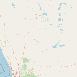
Map view of Avon Valley National Park

Use this park location map to pinpoint Avon Valley National Park in Australia, understand its exact geographic position, and read its mapped placement within the surrounding landscape more clearly.

Pigeon | © OpenStreetMap contributors

Location context for Avon Valley National Park

Western Australia
Park atlas

Trace the geographic spread of protected areas and compare similar landscapes across Western Australia near Avon Valley National Park.

Explore Nearby National Parks and Protected Areas Beyond Avon Valley National Park in Western Australia
After exploring Avon Valley National Park, browse other national parks and protected areas situated within its surrounding region of Western Australia. Gain valuable regional context and compare diverse conservation landscapes, from river valleys to granite outcrops, to deepen your geographic understanding.
National parkWestern Australia

John Forrest National Park: National Park Atlas and Western Australia Protected Landscape

Mapped boundaries and regional geographic context.

Delve into the atlas-level details of John Forrest National Park, a protected area situated in Western Australia. This park's designation as a national park provides a focal point for understanding its specific geographic features and mapped extent. Users can explore its place within the broader regional geography of Western Australia, gaining structured insight into the protected landscape.

Area
26.78 km²
Established
1900
IUCN
II
Relief
Upland
National parkWestern Australia

Greenmount National Park: Western Australia National Park Landscape and Geography Atlas

Explore its protected boundaries and regional landscape context.

Greenmount National Park represents a distinct protected landscape within the diverse geography of Western Australia. As a National Park, its mapped boundaries are integral to understanding its regional context and offering users a point of detailed geographic discovery. This entry provides essential data on its protected status and geographic setting, supporting exploration of Australia's significant natural areas through an atlas-driven lens.

Area
2.02 km²
Established
1970
IUCN
II
Relief
Upland
National parkWestern Australia

Beelu National Park: Exploring Western Australia's Protected Jarrah-Marri Forest Landscape

Mapped Geographic Context & Natural Terrain Discovery

Beelu National Park, situated in Western Australia's Darling Range, offers an immersive experience within old-growth jarrah-marri forests. This protected area provides a vital glimpse into the region's natural landscapes, characterized by rolling hills and the Helena River valley. Users can explore the park's geographic setting, its mapped boundaries, and the unique ecological context it preserves. It stands as a significant natural reserve contributing to the understanding of Western Australia's conservation efforts and diverse terrain.

Area
46.17 km²
Established
1995
IUCN
II
Relief
Highland
National parkWestern Australia

Gooseberry Hill National Park: A Protected Landscape in Western Australia's Geography

Explore mapped boundaries and regional park context.

Gooseberry Hill National Park is a significant protected area designated as a national park within the diverse geography of Western Australia. This entry provides detailed insights into its specific location, mapped boundaries, and role as a conservation landscape. Understand how Gooseberry Hill National Park contributes to the broader atlas of protected lands in Western Australia, offering a foundational view for geographic exploration and landscape context.

Area
0.33 km²
Established
1970
IUCN
II
Relief
Highland
Watercolor illustration of a landscape with rolling hills, trees, and fields
National parkWestern Australia

Kalamunda National Park: Explore Darling Scarp Woodland & Western Australia's Natural Terrain

A protected national park with distinct mapped landscape features.

Kalamunda National Park is an essential protected area located on the western slopes of the Darling Scarp, offering a clear representation of southwestern Australia's characteristic eucalypt woodland ecosystems. Its geography is defined by the escarpment's terrain, supporting tall marri, jarrah, and wandoo forests with a diverse understorey. As a national park, it provides critical habitat and contributes to the regional landscape context within Western Australia, making it a valuable point for atlas-driven discovery of protected natural areas.

Area
3.75 km²
Established
1964
IUCN
II
Relief
Mixed relief
National parkWestern Australia

Neerabup National Park: Discover its Protected Landscape and Geographic Identity in Western Australia

Explore mapped boundaries and regional context.

Neerabup National Park represents a crucial protected landscape within Western Australia, offering a distinct geographic identity for atlas-based discovery. This page focuses on its role as a national park, detailing its mapped boundaries and situating it within the rich regional geography of Western Australia. Users can explore the park's unique natural terrain and understand its contribution to the state's protected areas.

Area
9.43 km²
Established
1965
IUCN
II
Relief
Lowland
National parkWestern Australia

Yanchep National Park: Explore Its Unique Limestone Caves and Protected Bushland Geography

Discover the subterranean formations and coastal plain landscapes.

Yanchep National Park offers a singular opportunity for atlas-driven exploration of Western Australia's natural and cultural heritage. Situated on the Swan Coastal Plain, this national park is celebrated for its extensive network of limestone caves, including the notable Crystal Cave, providing a rare glimpse into subterranean geological processes. Beyond its underground wonders, the park encompasses diverse native bushland, supporting iconic koala colonies and offering insights into the region's ecological distinctiveness. Its deep Nyoongar heritage further enriches the understanding of this mapped protected landscape.

Area
28.76 km²
Established
1957
IUCN
II
Relief
Lowland
National parkWestern Australia

Korung National Park: Protected Landscape and Map Context in Western Australia

Discover its unique dual bioregion geography.

Korung National Park is a protected national park in Western Australia, noted for its position along the Darling Scarp overlooking the Swan Coastal Plain. This reserve provides accessible natural experiences and showcases the ecological transition between two major southwest Australian bioregions. Its mapped landscapes offer a clear example of regional protected area planning and its importance for biodiversity conservation in the Perth metropolitan area.

Area
63.54 km²
Established
2004
IUCN
II
Relief
Mixed relief

Common questions about visiting, size, designation, and location context for Avon Valley National Park

Avon Valley National Park FAQs for park facts, access, geography, and protected area context
Find quick answers about Avon Valley National Park, including protected-area facts, park geography, trail and visitor context, and how the park fits into its surrounding country and regional landscape.
MoriAtlas Explorer

Continue Your Protected Areas Search Across the Global Atlas

Deepen your exploration by continuing the structured search for national parks and protected areas worldwide. Utilize the comprehensive filtering capabilities to compare different conservation landscapes and refine your understanding of global park geography. Discover more about the distribution and characteristics of protected natural areas.

Global natural geography