

Mori Atlas logo
National parkGooseberry Hill National Park

Trace the protected boundaries and landscape context of this national park in Western Australia.

Gooseberry Hill National Park: Western Australia National Park Atlas and Geographic Exploration

Gooseberry Hill National Park stands as a protected natural area within the vast geographic expanse of Western Australia. As a designated national park, it offers a unique lens through which to explore mapped landscapes and understand regional conservation. This entry serves as a gateway to understanding the park's specific geographic identity and its role within the larger atlas of protected areas in Western Australia, providing foundational context for further discovery.

Darling Scarpjarrah woodlandpanoramic viewsscenic driveWestern Australiaurban proximity

Gooseberry Hill National Park

National park

Park overview

Structured park overview, official facts, and landscape profile for Gooseberry Hill National Park

Gooseberry Hill National Park park facts, protected area profile, and essential visitor context
Review the core facts for Gooseberry Hill National Park, including designation, size, terrain, visitor scale, habitats, and operating context in one park-focused overview.

About Gooseberry Hill National Park

Gooseberry Hill National Park occupies a scenic position on the western edge of the Darling Scarp, approximately 21 kilometres east of Perth's central business district. The park's location at the southern side of the Helena Valley mouth places it on elevated terrain where the scarp descends sharply toward the Swan Coastal Plain below. The reserve was established in 1970 and is managed by the Western Australian Department of Environment and Conservation, formerly known as the Department of Environment and Conservation. The park's terrain is characterised by steep slopes and ridgelines that support a woodland ecosystem dominated by jarrah and marri trees, both iconic species of the Swanland bioregion. Within the park boundaries lies Statham's Quarry, a site of historical significance related to early settler activity in the area. The park takes its name from Gooseberry Hill, which was named by early European settlers after a hill in Yorkshire, England, reflecting the British colonial naming practices common in Western Australia's settlement period. The park provides a natural setting close to the Perth metropolitan area where visitors can experience native woodland, historical heritage, and elevated viewpoints without traveling far from the city.

Quick facts and research context for Gooseberry Hill National Park

Gooseberry Hill National Park covers 33 hectares (82 acres) of elevated terrain on the Darling Scarp in Western Australia. The park lies 21 kilometres east of Perth CBD and is managed by the Western Australian Department of Environment and Conservation. Its defining feature is the single-lane bitumen zig zag scenic drive that ascends the steep terrain along the route of the former Kalamunda Zig Zag railway. Statham's Quarry, a historical site of local significance, is located within the park boundaries. The park features walking tracks through jarrah and marri woodland, with panoramic views over the Swan Coastal Plain available from elevated points. There are no entry fees and no visitor facilities provided.

Park context

Deeper park guide and search-rich context for Gooseberry Hill National Park

Gooseberry Hill National Park history, landscape, wildlife, and travel context
Explore Gooseberry Hill National Park through its history, landscape character, ecosystems, wildlife, conservation priorities, cultural context, and seasonal travel timing in a structured park guide built for atlas discovery and search intent.

Why Gooseberry Hill National Park stands out

Gooseberry Hill National Park is best known for its distinctive zig zag scenic drive, a single-lane asphalt road that winds up the steep Darling Scarp terrain following the historic alignment of the former Kalamunda Zig Zag railway. This engineered route offers excellent panoramic views across the Swan Coastal Plain and the Perth skyline in the distance. The park is also notable for its position as an elevated woodland sanctuary close to a major city, protecting a remnant pocket of jarrah and marri forest on the scarp. The combination of historical industrial heritage (the former railway route), native woodland, and dramatic viewpoints makes this small park a distinctive destination in the Perth region.

Gooseberry Hill National Park history and protected-area timeline

Gooseberry Hill National Park was established in 1970 as a protected area under Western Australian state governance. The park was named by early European settlers who established properties in the Helena Valley region during the colonial period, with the name inspired by a hill in Yorkshire, England. The most significant historical feature within the park is the zig zag scenic drive, which follows the formation of the former Kalamunda Zig Zag railway, an early industrial railway that once carried passengers and goods up the steep Darling Scarp terrain. This railway, known as the Kalamunda Zig Zag, was an engineering achievement of its era and operated from the late 19th century until its closure. The railway formation was adapted into the current vehicular drive route, preserving a visible trace of the region's industrial heritage within the protected landscape. Statham's Quarry within the park represents another element of the area's historical use, related to early stone extraction activities by settlers. The park remains under the management of the Western Australian government's environment and conservation department, which oversees protected areas throughout the state.

Gooseberry Hill National Park landscape and geographic character

The landscape of Gooseberry Hill National Park is defined by its position on the western face of the Darling Scarp, a major geological escarpment that forms the eastern edge of the Swan Coastal Plain. The terrain rises steeply from the valley floor, with the park occupying elevated positions that provide commanding views across the coastal plain toward the Indian Ocean horizon. The underlying geology of the Darling Scarp consists of ancient granite and metamorphic rocks of the Yilgarn Craton, with laterite soils and sandy residuals typical of the region. The park's slopes support open woodland with jarrah as the dominant tree species, interspersed with marri and occasionalwandoo in lower-lying areas. The terrain features ridgelines and gentle valleys that create visual diversity within the small park area. The most distinctive landscape element is the zig zag formation itself, where the former railway alignment cuts a visible path up the slope, creating an engineered landscape feature that contrasts with the natural woodland surroundings.

Gooseberry Hill National Park ecosystems, habitats, and plant life

The natural environment of Gooseberry Hill National Park reflects the jarrah forest ecosystem that historically covered large areas of the Darling Scarp and the wider Swanland bioregion. The park protects woodland dominated by jarrah (Eucalyptus marginata), a iconic Western Australian tree species that is well adapted to the nutrient-poor soils of the region. Marri (Corymbia calophylla) is a co-dominant species in the woodland, providing a diverse canopy structure. The understory comprises a mix of shrubs and grasses adapted to the Mediterranean climate of southwestern Australia, including various Acacia species, grevilleas, and grass trees where fire has not recently passed. The park's position on the scarp creates microclimatic variations, with aspects ranging from full sun on western exposures to shadier conditions in sheltered valleys. The woodland supports a variety of native fauna, including birds, reptiles, and mammals typical of the jarrah forest, though the small size of the reserve limits the extent of habitat available for larger species.

Gooseberry Hill National Park wildlife and species highlights

Gooseberry Hill National Park provides habitat for various native wildlife species adapted to the jarrah woodland of the Darling Scarp region. Birdlife is diverse, with honeyeaters such as the Singing Honeyeater and Brown Honeyeater commonly found in the woodland canopy. The park's trees provide foraging resources and nesting sites for various parrot species, including the introduced Rainbow Lorikeet alongside native species. Woodland birds such as robins and fantails are present in the understory. Reptiles including skinks and dragons inhabit the ground layer and rocky areas, while mammals such as possums may utilise tree hollows. The small size of the reserve and its proximity to the Perth metropolitan area means the wildlife community is somewhat modified compared to more remote jarrah forest areas, but the protected woodland still supports meaningful biodiversity within the regional context.

Gooseberry Hill National Park conservation status and protection priorities

Gooseberry Hill National Park serves as a conservation reserve protecting a remnant pocket of jarrah and marri woodland within the Perth metropolitan region. While the 33-hectare area is small, it contributes to the network of protected areas that preserve the biodiversity of the Swanland bioregion. The jarrah forest ecosystem has been significantly reduced by clearing for agriculture, urban development, and mining since European settlement, making remaining protected areas such as Gooseberry Hill increasingly important for conservation. The park protects representative samples of scarp woodland vegetation and provides habitat for native species in an area otherwise affected by urban expansion. The retention of the historical zig zag formation also preserves a cultural landscape element while maintaining the natural values of the reserve.

Gooseberry Hill National Park cultural meaning and human context

The cultural context of Gooseberry Hill National Park reflects both indigenous heritage and European settlement history. The area is part of the traditional lands of the Noongar people, the Indigenous custodians of the southwestern region of Western Australia, though the Wikipedia source provides limited specific detail on indigenous cultural associations with this particular site. The European naming of Gooseberry Hill after a hill in Yorkshire exemplifies the colonial practice of naming new places after familiar locations in Britain. The presence of Statham's Quarry within the park indicates early settler use of the landscape for stone extraction, while the Kalamunda Zig Zag railway represents the industrial heritage of the region. This combination of indigenous heritage, colonial naming, and industrial history creates a layered cultural landscape that coexists with the natural values of the protected area.

Top sights and standout views in Gooseberry Hill National Park

The defining highlight of Gooseberry Hill National Park is the zig zag scenic drive, a unique driving experience that follows the formation of the former Kalamunda Zig Zag railway up the steep Darling Scarp. This single-lane bitumen road provides access to panoramic viewpoints overlooking the Swan Coastal Plain and the distant Perth skyline. The walking tracks through jarrah and marri woodland offer visitors the opportunity to explore the native vegetation of the scarp. The historical significance of the railway formation adds heritage value to the natural landscape. The park's proximity to Perth makes it an accessible natural escape for city residents seeking elevated views and woodland scenery without traveling to more distant national parks.

Best time to visit Gooseberry Hill National Park

The best time to visit Gooseberry Hill National Park is during the cooler months of autumn, winter, and early spring in Western Australia, typically from April through October. During these seasons, the weather is mild and pleasant for outdoor activities such as walking and scenic driving. Spring brings wildflower blooms throughout the jarrah woodland, adding colour to the landscape. Summer months in Perth can be very hot and dry, making outdoor exploration less comfortable, though early morning or late afternoon visits may still be enjoyable. The park can be visited year-round as there are no closures or seasonal restrictions, but the cooler months provide more comfortable conditions for appreciating the panoramic views from the scarp and walking the tracks through the woodland.
Park location guide

Geography guide, regional context, and park location map for Gooseberry Hill National Park

Gooseberry Hill National Park park geography, regions, and map view in Australia
Understand where Gooseberry Hill National Park sits in Australia through a broader geographic reading of the surrounding landscape, nearby location context, and its mapped position within the national park landscape.

How Gooseberry Hill National Park fits into Australia

Australia is a constitutional monarchy and federal parliamentary democracy comprising six states and ten territories. With a population of nearly 28 million, it is one of the world's most urbanised countries, with most people concentrated on the eastern seaboard. The country has a high Human Development Index and is known for its cultural diversity, ancient Aboriginal heritage, and unique wildlife.

Wider geography shaping Gooseberry Hill National Park in Australia

Australia occupies the entire Australian continent, the island of Tasmania, and numerous smaller islands. It is the world's flattest and driest inhabited continent, featuring vast deserts in the interior (the Outback), tropical rainforests along the eastern coast, and a coastline bordering the Indian and Pacific Oceans.

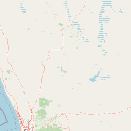
Map view of Gooseberry Hill National Park

Use this park location map to pinpoint Gooseberry Hill National Park in Australia, understand its exact geographic position, and read its mapped placement within the surrounding landscape more clearly.

Pigeon | © OpenStreetMap contributors

Location context for Gooseberry Hill National Park

Western Australia
Park atlas

Compare protected landscapes, trace regional park geography, and map adjacent natural areas after Gooseberry Hill National Park.

Discover Other National Parks Near Gooseberry Hill National Park and Its Surrounding Region
Browse other national parks and protected areas located in close geographic proximity or within similar Darling Scarp woodland ecosystems around Gooseberry Hill National Park. Discover diverse conservation landscapes across Western Australia, compare their unique features, and understand their regional context through detailed atlas mapping.
Watercolor illustration of a landscape with rolling hills, trees, and fields
National parkWestern Australia

Kalamunda National Park: Explore Darling Scarp Woodland & Western Australia's Natural Terrain

A protected national park with distinct mapped landscape features.

Kalamunda National Park is an essential protected area located on the western slopes of the Darling Scarp, offering a clear representation of southwestern Australia's characteristic eucalypt woodland ecosystems. Its geography is defined by the escarpment's terrain, supporting tall marri, jarrah, and wandoo forests with a diverse understorey. As a national park, it provides critical habitat and contributes to the regional landscape context within Western Australia, making it a valuable point for atlas-driven discovery of protected natural areas.

Area
3.75 km²
Established
1964
IUCN
II
Relief
Mixed relief
National parkWestern Australia

Greenmount National Park: Western Australia National Park Landscape and Geography Atlas

Explore its protected boundaries and regional landscape context.

Greenmount National Park represents a distinct protected landscape within the diverse geography of Western Australia. As a National Park, its mapped boundaries are integral to understanding its regional context and offering users a point of detailed geographic discovery. This entry provides essential data on its protected status and geographic setting, supporting exploration of Australia's significant natural areas through an atlas-driven lens.

Area
2.02 km²
Established
1970
IUCN
II
Relief
Upland
National parkWestern Australia

John Forrest National Park: National Park Atlas and Western Australia Protected Landscape

Mapped boundaries and regional geographic context.

Delve into the atlas-level details of John Forrest National Park, a protected area situated in Western Australia. This park's designation as a national park provides a focal point for understanding its specific geographic features and mapped extent. Users can explore its place within the broader regional geography of Western Australia, gaining structured insight into the protected landscape.

Area
26.78 km²
Established
1900
IUCN
II
Relief
Upland
National parkWestern Australia

Beelu National Park: Exploring Western Australia's Protected Jarrah-Marri Forest Landscape

Mapped Geographic Context & Natural Terrain Discovery

Beelu National Park, situated in Western Australia's Darling Range, offers an immersive experience within old-growth jarrah-marri forests. This protected area provides a vital glimpse into the region's natural landscapes, characterized by rolling hills and the Helena River valley. Users can explore the park's geographic setting, its mapped boundaries, and the unique ecological context it preserves. It stands as a significant natural reserve contributing to the understanding of Western Australia's conservation efforts and diverse terrain.

Area
46.17 km²
Established
1995
IUCN
II
Relief
Highland
National parkWestern Australia

Korung National Park: Protected Landscape and Map Context in Western Australia

Discover its unique dual bioregion geography.

Korung National Park is a protected national park in Western Australia, noted for its position along the Darling Scarp overlooking the Swan Coastal Plain. This reserve provides accessible natural experiences and showcases the ecological transition between two major southwest Australian bioregions. Its mapped landscapes offer a clear example of regional protected area planning and its importance for biodiversity conservation in the Perth metropolitan area.

Area
63.54 km²
Established
2004
IUCN
II
Relief
Mixed relief
National parkPerth metropolitan region

Midgegooroo National Park: Jarrah Forest Protected Landscape and Regional Geography

Explore its mapped boundaries and terrain near Perth.

Midgegooroo National Park offers a distinct protected landscape characterized by its expansive jarrah forest terrain within the Perth metropolitan region. This national park provides valuable context for understanding regional geography, mapped natural features, and the distribution of protected lands. Explore the park's unique topography and conservation boundaries, vital for comprehensive atlas-based geographic discovery.

Area
24.92 km²
Established
2004
IUCN
II
Relief
Upland
National parkWestern Australia

Helena National Park: National Park with Regional Geographic Context in Western Australia

Mapping protected area boundaries and natural landscapes.

Helena National Park represents a significant protected area within the expansive geography of Western Australia. This page facilitates detailed exploration of its national park status, offering insights into its mapped boundaries and the regional landscape context. Discover how Helena National Park contributes to the protected land atlas of Western Australia, providing a specific focus for geographic understanding and park exploration.

Area
122.55 km²
Established
2004
Relief
Upland
Climate
Mediterranean
National parkWestern Australia

Avon Valley National Park: Protected National Park Discovery in Western Australia

Explore mapped boundaries and regional landscape context.

Delve into Avon Valley National Park, a designated national park offering rich opportunities for protected-area and landscape discovery. This page serves as an atlas-style entry point, detailing the park's mapped geography and its role within the diverse natural terrain of Western Australia. Understand its specific protected landscape identity and how it contributes to the broader conservation map.

Area
43.66 km²
Established
1970
IUCN
II
Relief
Mixed relief

Common questions about visiting, size, designation, and location context for Gooseberry Hill National Park

Gooseberry Hill National Park FAQs for park facts, access, geography, and protected area context
Find quick answers about Gooseberry Hill National Park, including protected-area facts, park geography, trail and visitor context, and how the park fits into its surrounding country and regional landscape.
MoriAtlas Explorer

Continue Your Protected Areas Search Across the Global Atlas

Deepen your exploration by continuing the structured search for national parks and protected areas worldwide. Utilize the comprehensive filtering capabilities to compare different conservation landscapes and refine your understanding of global park geography. Discover more about the distribution and characteristics of protected natural areas.

Global natural geography