

Mori Atlas logo
National parkGreenmount National Park

Discover the geographic extent and protected land context of Greenmount National Park.

Greenmount National Park: Western Australia National Park Map and Protected Landscape Geography

Greenmount National Park stands as a significant protected area within the vast geographic expanse of Western Australia. As a designated National Park, its boundaries define a critical landscape for atlas-based discovery and understanding Australia's natural heritage. This page offers detailed insight into the park's mapped territory, its regional geographic setting, and its role as a protected natural landscape.

Western Australia national parksDarling Scarp reservesWildlife corridorsRock climbing locationsHeritage trailsEucalypt woodlands

Greenmount National Park

National park

Park overview

Structured park overview, official facts, and landscape profile for Greenmount National Park

Greenmount National Park park facts, protected area profile, and essential visitor context
Review the core facts for Greenmount National Park, including designation, size, terrain, visitor scale, habitats, and operating context in one park-focused overview.

About Greenmount National Park

Greenmount National Park occupies a strategic position on the western face of the Darling Scarp, where the steep ridgeline of Greenmount Hill provides dramatic elevation above the Swan Coastal Plain. Despite its modest size of 2.02 square kilometres, the park serves as an essential ecological link in a chain of protected areas that follow the scarp northward from the Perth region. The landscape is characterized by steep slopes, rocky breakaways, and exposed stone outcrops that define the hill's character. Dominant tree species include marri and wandoo eucalypts, which form open woodlands across the slopes, while the northern aspects support heathland and wildflower communities. The park's proximity to Perth makes it accessible for day visitors seeking natural environments close to the city, though its significance extends beyond recreation to include historical, cultural, and ecological dimensions that warrant protection.

Quick facts and research context for Greenmount National Park

Greenmount National Park covers 2.02 square kilometres along the Darling Scarp east of Perth. The park was established in 1970 and is managed by the Western Australia's Department of Environment and Conservation. It contains the historic Mountain Quarry, a blue stone quarry popular with rock climbers, and is traversed by the Railway Reserves Heritage Trail. The park features steep terrain with rocky outcrops and breakaways, dominated by marri and wandoo eucalypt woodlands. The Helena River Valley adjacent to the park holds significance in Aboriginal folklore.

Park context

Deeper park guide and search-rich context for Greenmount National Park

Greenmount National Park history, landscape, wildlife, and travel context
Explore Greenmount National Park through its history, landscape character, ecosystems, wildlife, conservation priorities, cultural context, and seasonal travel timing in a structured park guide built for atlas discovery and search intent.

Why Greenmount National Park stands out

Greenmount National Park is best known for its role as a critical wildlife corridor along the Darling Scarp, connecting John Forrest National Park to reserves to the south. It is also recognized for the historic Mountain Quarry, ablue stone quarry that has become a popular destination for rock climbers and walkers. The park offers panoramic views over the Swan Coastal Plain and Perth from its elevated ridge position, and contains sections of the Railway Reserves Heritage Trail.

Greenmount National Park history and protected-area timeline

The park's establishment in 1970 formalized protection for an area that had long held significance for both Aboriginal peoples and European settlers. Historical records indicate that the adjacent Helena River Valley featured prominently in early European explorer diaries and holds importance in Aboriginal folklore. The park's relationship to John Forrest National Park is particularly notable: that larger preserve was originally designated as Greenmount National Park until 1928, when it was renamed in honour of Sir John Forrest. Bus tours operated through the park as early as the 1930s, with Hill's Bus Tours offering Sunday excursions in 1937. The Mountain Quarry within the park represents an early industrial operation, its blue stone extraction leaving a legacy that now attracts climbers rather than quarriers. The Railway Reserves Heritage Trail, which follows the former railway corridor through the park, provides historical interpretation panels documenting the site's past.

Greenmount National Park landscape and geographic character

The park sits atop Greenmount Hill, a steep-sided eminence that rises sharply from the surrounding Darling Range terrain. The ridge orientation creates a western-facing slope that overlooks the Swan Coastal Plain, with sweeping views westward toward Perth and the coast. Rocky breakaways and stone outcrops punctuate the hillside, giving the landscape visual interest and providing habitat for specialized plant and animal species. The terrain is intersected by firebreaks that locals use as walking routes, and the park's western and northern slopes are visible from Great Eastern Highway. The Helena River Valley lies adjacent to the park, adding riparian context to the otherwise steep, ridgeline setting.

Greenmount National Park ecosystems, habitats, and plant life

The vegetation of Greenmount National Park reflects the transitional nature of the Darling Scarp environment between the wetter forested uplands and the drier coastal plain below. Marri and wandoo eucalypts form the primary tree cover, creating an open woodland structure that allows sunlight to reach the understory. The northern-facing slopes support heathland communities characterized by diverse wildflower displays, while the more sheltered gullies contain denser shrub thickets. The park's position along the scarp places it within a recognized wildlife corridor, enabling movement of fauna between larger protected areas. Invasive Watsonia infestations have affected the western and northern slopes, representing an ongoing management challenge.

Greenmount National Park wildlife and species highlights

While the source material does not provide detailed species inventories, the park's location along the Darling Scarp wildlife corridor suggests it supports diverse fauna adapted to the eucalypt woodland and heathland habitats. The corridor function is significant, as the park connects John Forrest National Park to reserves extending southward along the scarp, facilitating genetic exchange between wildlife populations in what would otherwise be fragmented habitat. The combination of woodland, heathland, and rocky outcrops provides diverse microhabitats supporting birds, reptiles, and small mammals.

Greenmount National Park conservation status and protection priorities

Greenmount National Park's primary conservation significance lies in its role as a wildlife corridor along the Darling Scarp, a function that has become increasingly important as urban development spreads across the Perth region. The park forms part of a network of reserves that maintain ecological connectivity between larger protected areas, enabling wildlife movement and supporting biodiversity. The steep terrain and rocky substrates also providehabitat that would be difficult to develop, preserving remnant vegetation in an area experiencing growth pressure. Conservation challenges include managing invasive species such as Watsonia and maintaining the corridor's integrity despite the park's small size.

Greenmount National Park cultural meaning and human context

The Helena River Valley adjacent to the park holds significance in Aboriginal folklore, representing one of the earliest documented connections between the landscape and human cultural meaning in the Perth region. Early European settler diaries also reference this area, indicating its prominence in the colonial understanding of the regional geography. The Mountain Quarry provides a more recent layer of cultural heritage, representing early twentieth-century stone extraction operations. The Railway Reserves Heritage Trail, which passes through the park, preserves the corridor of the former railway and includes interpretive panels explaining the site's historical significance.

Top sights and standout views in Greenmount National Park

The historic Mountain Quarry, with its blue stone walls, offers a unique climbing and walking destination within the park. The Railway Reserves Heritage Trail follows the old railway corridor through the area, providing recreational access and historical interpretation. Panoramic views over the Swan Coastal Plain and Perth skyline reward visitors who ascend to the ridgeline. The park's role as a wildlife corridor connecting larger reserves makes it significant beyond its small size, while its proximity to Perth provides easy access to a natural environment that might otherwise require much longer travel.

Best time to visit Greenmount National Park

The park can be visited year-round, though the cooler months from autumn through spring typically offer more comfortable conditions for walking and climbing activities. Summer months carry elevated bushfire risk, and the park has experienced significant fire damage in the past, particularly on southern slopes. Wildflower displays on the northern heathland slopes are most pronounced in spring. The accessible nature of the park from Perth makes it suitable for spontaneous visits, though weekdays may offer more solitude than weekends.
Park location guide

Geography guide, regional context, and park location map for Greenmount National Park

Greenmount National Park park geography, regions, and map view in Australia
Understand where Greenmount National Park sits in Australia through a broader geographic reading of the surrounding landscape, nearby location context, and its mapped position within the national park landscape.

How Greenmount National Park fits into Australia

Australia is a constitutional monarchy and federal parliamentary democracy comprising six states and ten territories. With a population of nearly 28 million, it is one of the world's most urbanised countries, with most people concentrated on the eastern seaboard. The country has a high Human Development Index and is known for its cultural diversity, ancient Aboriginal heritage, and unique wildlife.

Wider geography shaping Greenmount National Park in Australia

Australia occupies the entire Australian continent, the island of Tasmania, and numerous smaller islands. It is the world's flattest and driest inhabited continent, featuring vast deserts in the interior (the Outback), tropical rainforests along the eastern coast, and a coastline bordering the Indian and Pacific Oceans.

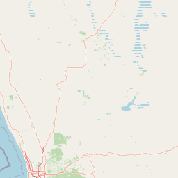
Map view of Greenmount National Park

Use this park location map to pinpoint Greenmount National Park in Australia, understand its exact geographic position, and read its mapped placement within the surrounding landscape more clearly.

Pigeon | © OpenStreetMap contributors

Location context for Greenmount National Park

Western Australia
Park atlas

Trace the regional spread of protected landscapes in Western Australia, comparing Greenmount's ridgeline location with adjacent conservation areas.

Browse Related National Parks and Protected Areas Near Greenmount National Park
Explore other national parks and protected areas in Western Australia, expanding your understanding of the region's diverse conservation landscapes beyond Greenmount National Park. This geographic overview allows for direct comparison of terrain, ecological roles, and regional context among adjacent protected areas, enhancing your atlas-style park discovery.
National parkWestern Australia

John Forrest National Park: National Park Atlas and Western Australia Protected Landscape

Mapped boundaries and regional geographic context.

Delve into the atlas-level details of John Forrest National Park, a protected area situated in Western Australia. This park's designation as a national park provides a focal point for understanding its specific geographic features and mapped extent. Users can explore its place within the broader regional geography of Western Australia, gaining structured insight into the protected landscape.

Area
26.78 km²
Established
1900
IUCN
II
Relief
Upland
National parkWestern Australia

Gooseberry Hill National Park: A Protected Landscape in Western Australia's Geography

Explore mapped boundaries and regional park context.

Gooseberry Hill National Park is a significant protected area designated as a national park within the diverse geography of Western Australia. This entry provides detailed insights into its specific location, mapped boundaries, and role as a conservation landscape. Understand how Gooseberry Hill National Park contributes to the broader atlas of protected lands in Western Australia, offering a foundational view for geographic exploration and landscape context.

Area
0.33 km²
Established
1970
IUCN
II
Relief
Highland
Watercolor illustration of a landscape with rolling hills, trees, and fields
National parkWestern Australia

Kalamunda National Park: Explore Darling Scarp Woodland & Western Australia's Natural Terrain

A protected national park with distinct mapped landscape features.

Kalamunda National Park is an essential protected area located on the western slopes of the Darling Scarp, offering a clear representation of southwestern Australia's characteristic eucalypt woodland ecosystems. Its geography is defined by the escarpment's terrain, supporting tall marri, jarrah, and wandoo forests with a diverse understorey. As a national park, it provides critical habitat and contributes to the regional landscape context within Western Australia, making it a valuable point for atlas-driven discovery of protected natural areas.

Area
3.75 km²
Established
1964
IUCN
II
Relief
Mixed relief
National parkWestern Australia

Beelu National Park: Exploring Western Australia's Protected Jarrah-Marri Forest Landscape

Mapped Geographic Context & Natural Terrain Discovery

Beelu National Park, situated in Western Australia's Darling Range, offers an immersive experience within old-growth jarrah-marri forests. This protected area provides a vital glimpse into the region's natural landscapes, characterized by rolling hills and the Helena River valley. Users can explore the park's geographic setting, its mapped boundaries, and the unique ecological context it preserves. It stands as a significant natural reserve contributing to the understanding of Western Australia's conservation efforts and diverse terrain.

Area
46.17 km²
Established
1995
IUCN
II
Relief
Highland
National parkWestern Australia

Korung National Park: Protected Landscape and Map Context in Western Australia

Discover its unique dual bioregion geography.

Korung National Park is a protected national park in Western Australia, noted for its position along the Darling Scarp overlooking the Swan Coastal Plain. This reserve provides accessible natural experiences and showcases the ecological transition between two major southwest Australian bioregions. Its mapped landscapes offer a clear example of regional protected area planning and its importance for biodiversity conservation in the Perth metropolitan area.

Area
63.54 km²
Established
2004
IUCN
II
Relief
Mixed relief
National parkPerth metropolitan region

Midgegooroo National Park: Jarrah Forest Protected Landscape and Regional Geography

Explore its mapped boundaries and terrain near Perth.

Midgegooroo National Park offers a distinct protected landscape characterized by its expansive jarrah forest terrain within the Perth metropolitan region. This national park provides valuable context for understanding regional geography, mapped natural features, and the distribution of protected lands. Explore the park's unique topography and conservation boundaries, vital for comprehensive atlas-based geographic discovery.

Area
24.92 km²
Established
2004
IUCN
II
Relief
Upland
National parkWestern Australia

Helena National Park: National Park with Regional Geographic Context in Western Australia

Mapping protected area boundaries and natural landscapes.

Helena National Park represents a significant protected area within the expansive geography of Western Australia. This page facilitates detailed exploration of its national park status, offering insights into its mapped boundaries and the regional landscape context. Discover how Helena National Park contributes to the protected land atlas of Western Australia, providing a specific focus for geographic understanding and park exploration.

Area
122.55 km²
Established
2004
Relief
Upland
Climate
Mediterranean
National parkWestern Australia

Avon Valley National Park: Protected National Park Discovery in Western Australia

Explore mapped boundaries and regional landscape context.

Delve into Avon Valley National Park, a designated national park offering rich opportunities for protected-area and landscape discovery. This page serves as an atlas-style entry point, detailing the park's mapped geography and its role within the diverse natural terrain of Western Australia. Understand its specific protected landscape identity and how it contributes to the broader conservation map.

Area
43.66 km²
Established
1970
IUCN
II
Relief
Mixed relief

Common questions about visiting, size, designation, and location context for Greenmount National Park

Greenmount National Park FAQs for park facts, access, geography, and protected area context
Find quick answers about Greenmount National Park, including protected-area facts, park geography, trail and visitor context, and how the park fits into its surrounding country and regional landscape.
MoriAtlas Explorer

Continue Your Protected Areas Search Across the Global Atlas

Deepen your exploration by continuing the structured search for national parks and protected areas worldwide. Utilize the comprehensive filtering capabilities to compare different conservation landscapes and refine your understanding of global park geography. Discover more about the distribution and characteristics of protected natural areas.

Global natural geography