
Mori Atlas logo
Nature reserveMotuara Island

Mapping the historic geography and coastal landscape at the mouth of Queen Charlotte Sound

Motuara Island Nature Reserve: A Protected Bird Sanctuary in the Marlborough Sounds

(Motuara Island Scenic and Historical Reserve)

Motuara Island serves as a crucial, pest-free nature reserve within the Marlborough Sounds of New Zealand. This 59-hectare landscape rises steeply from the waters of Cook Strait, featuring regenerating native forest and historic sites marking the 1770 proclamation. The island functions as both a vital bird sanctuary for reintroduced species and a prominent geographical waypoint at the intersection of the sounds and the open sea.

bird sanctuarypest-free islandregenerating native forestMarlborough SoundsCook Straitscenic and historical reserve
An illustration of a bright landscape featuring a tiered waterfall descending from cliffs into a winding river, framed by foreground trees and foliage under a stylized sun.

Motuara Island

Nature reserve

Park overview

Structured park overview, official facts, and landscape profile for Motuara Island

Motuara Island park facts, protected area profile, and essential visitor context

Review the core facts for Motuara Island, including designation, size, terrain, visitor scale, habitats, and operating context in one park-focused overview.

About Motuara Island

Motuara Island is the scenic and historical reserve that guards the entrance to Queen Charlotte Sound / Tōtaranui, acting almost like a sentinel at the gateway between the sheltered inner Marlborough Sounds and the open waters of Cook Strait. Although small in area, the island combines dense regenerating native forest, steep terrain dropping into the sea, and a remarkable accumulation of human history, from Māori settlement and early contact to one of the Pacific's most famous acts of European territorial claim.

The island's pre-contact role was shaped by its position. The entrance to Queen Charlotte Sound was a strategic chokepoint for waka travelling between the North and South Islands, and Motuara functioned as a staging post, meeting place and trading hub for pounamu (jade) and pakohe (argillite). Rangitāne people lived in kāinga near food-gathering areas around it, and over time a fortified pā was established on a partly attached rocky islet off the southeastern point, still known as Hippah Island for the early British use of the word for any fortified Māori site.

The Encounter with Cook, Tupaia and Topaa added a dense second chapter to Motuara's significance. During the first voyage of the Endeavour, Cook climbed to the summit with his officers, raised a flagstaff, and formally claimed Queen Charlotte Sound in the name of King George III, an act that has been reinterpreted with each passing anniversary. The island then served as a lookout, observatory, signal station and garden for subsequent voyagers, including Fabian von Bellingshausen. Its modern identity is built on conservation: declared a reserve in 1976, freed of rats in 1991, and now home to reintroduced native birds and a temporary kiwi crèche, Motuara is a compact but unusually rich example of how ecological restoration and contested shared history can sit side by side on the same small piece of land.

Quick facts and research context for Motuara Island

Motuara Island is part of New Zealand's network of scenic and historical reserves, administered by the Department of Conservation (DOC). The island lies at the entrance to Queen Charlotte Sound / Tōtaranui, one of the principal arms of the Marlborough Sounds in the northern South Island.

The reserve is uninhabited, with a permanent population of zero, and covers a compact, hilly landmass of approximately 59 hectares (about 150 acres). Its summit sits at roughly 128 meters above sea level, where a wooden lookout tower now offers sweeping views across the sound and out toward Cook Strait. The island's complete pest-free status is what allows its native-bird restoration work to succeed, and it also functions as a temporary rearing site for Okarito kiwi chicks as part of Operation Nest Egg.

Protection and recognition

Documented designation records, establishment year, and management scope overview

Motuara Island Protection Status and Terrestrial Conservation History

Motuara Island holds a documented terrestrial protection status established in 1976 with a localized management scope. Official designation records provide structured conservation history for ongoing geographical analysis.

Protection details

Protection scope
Terrestrial
Designated year
1976
Transboundary protection
No
Park context

Deeper park guide and search-rich context for Motuara Island

Motuara Island history, landscape, wildlife, and travel context

Explore Motuara Island through its history, landscape character, ecosystems, wildlife, conservation priorities, cultural context, and seasonal travel timing in a structured park guide built for atlas discovery and search intent.

Why Motuara Island stands out

Motuara Island is best known as the place where Captain James Cook performed the formal, and deeply contested, act of claiming Queen Charlotte Sound for the British Crown in January 1770. The summit, where a flagstaff once stood, a cairn was raised on the 150th anniversary, a lookout tower was built for the 200th, and an interpretation panel was added for the 250th, has become a layered monument to that history. It is equally renowned as a bird sanctuary. Rat eradication in 1991 allowed the bush to regenerate and reintroduction programmes to succeed, turning the small island into a reliable place to see South Island saddleback, robin, bellbird, tūī, fantail and grey warbler, and a seasonal refuge for Okarito kiwi chicks.
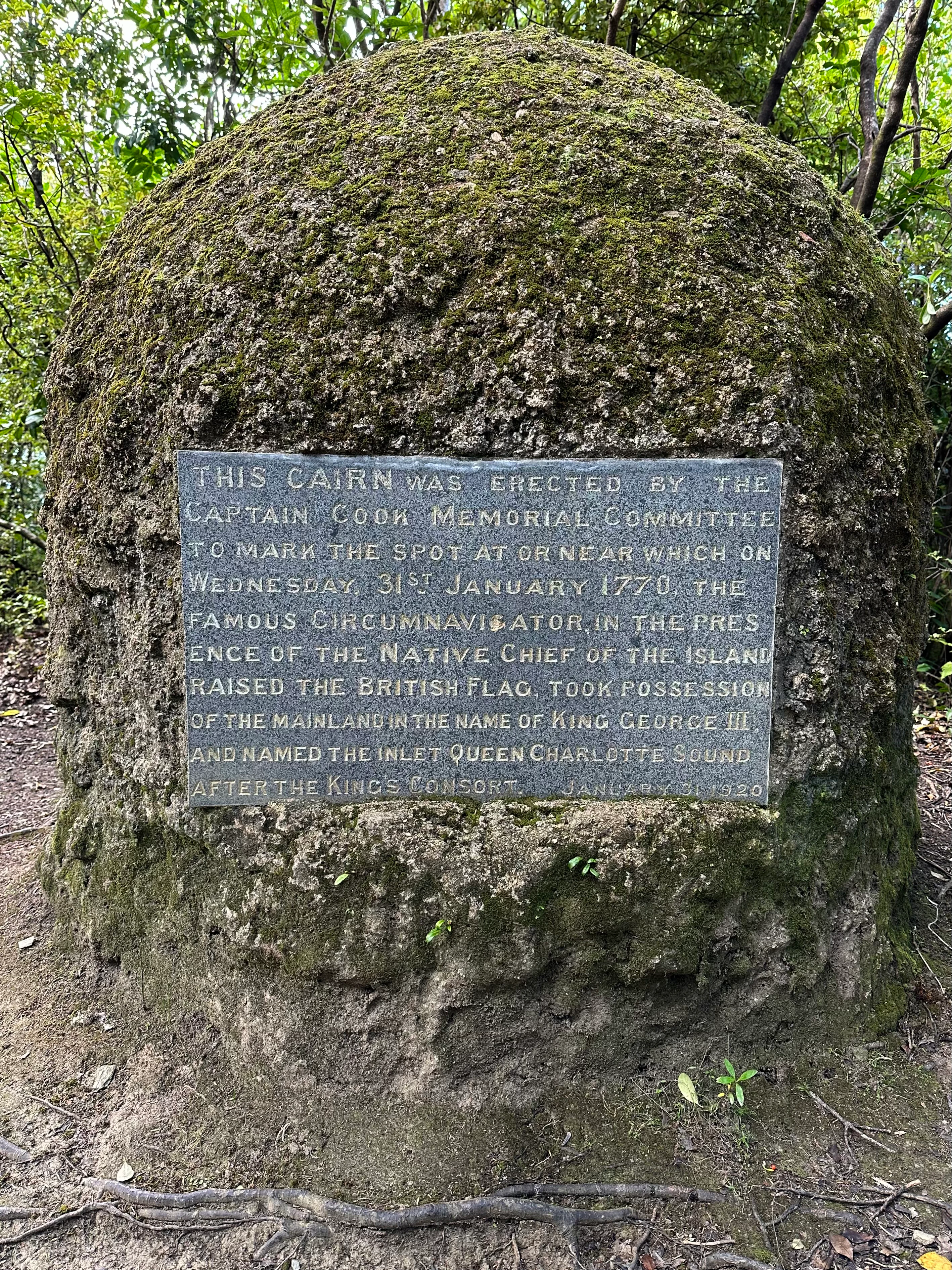
A weathered stone cairn covered in moss with an embedded metal plaque describing the 1770 historical event involving Captain James Cook on Motuara Island.
A stone cairn commemorating the site where Captain James Cook claimed British sovereignty in 1770.

Motuara Island history and protected-area timeline

Motuara Island's recorded history begins long before European contact, when the entrance to Queen Charlotte Sound served as a major route for waka crossing Cook Strait. Rangitāne people made the island and its surroundings a gathering place, trading pounamu from the South Island's west coast and pakohe from Nelson-Marlborough quarries. The fortified pā on the rocky outcrop now called Hippah Island, at Motuara's southeastern point, reflected the area's strategic importance, with different tribal groups contesting and merging over time.

The defining moment in the island's European history came on 31 January 1770, when James Cook, sailing on HMS Endeavour, climbed to the summit of Motuara and, in the presence of the local chief Topaa and other Rangitāne people, raised the Union Jack and claimed Queen Charlotte Sound for King George III. The act was carried out under sealed Admiralty orders that instructed Cook to take possession with the consent of the natives if they were present, a consent the Māori present did not understand as cession of sovereignty. Encounter between the Europeans and Māori at the island was smoothed by Tupaia, the Tahitian priest and interpreter who travelled on the Endeavour.

After the flag ceremony, Cook's men planted vegetable gardens and later Tobias Furneaux, separated from Cook during the second voyage, re-sown the gardens from HMS Adventure; some of these seeds eventually spread around New Zealand. From the mid-1800s, clearance for gardens and grazing by quarantined angora goats and later sheep steadily stripped the vegetation. All stock were removed in 1925, and the island was finally declared a scenic and historical reserve in 1976, administered by the Department of Conservation. A cairn was unveiled for the 150th anniversary of Cook's claim, a lookout tower was built by local clubs around the 200th, and an interpretation panel was installed for the 250th in consultation with local iwi, reframing the site's story around all the peoples who have travelled to it.

Motuara Island landscape and geographic character

Motuara Island is a small, hilly landmass roughly 59 hectares in size, rising to a summit of about 128 meters above sea level. The terrain rolls steeply from the central ridge down to the water, with regenerating native forest cloaking the slopes and giving way to a rocky shoreline that faces directly onto Cook Strait. The rugged, partly attached rocky islet off the southeastern point, with its cliffs and fortified pā terraces, forms one of the most distinctive landscape features of the reserve.

The summit is the island's most striking vantage point. From the wooden lookout tower, visitors can look back across Queen Charlotte Sound / Tōtaranui toward the surrounding hills of the Marlborough Sounds, and out toward the broad, often wind-driven waters of Cook Strait. The island's dramatic, exposed position at the sound's mouth gives it a far more rugged visual character than the sheltered, beached arms further inside the sounds.

Motuara Island ecosystems, habitats, and plant life

The ecological character of Motuara Island is shaped by regeneration rather than untouched wilderness. After rats were eradicated in 1991, the forest cover that had been progressively stripped through the 1800s and early 1900s began to return, with native bush reclaiming the slopes and gullies. The pest-free status of the reserve is the central fact that defines its natural value: it allows forest regeneration, invertebrate recovery, and the survival of reintroduced birds to proceed without the constant predation pressure that affects the surrounding mainland.

The island functions as a self-contained ecosystem enclave within the Marlborough Sounds. Its regenerating forest offers a refuge for native insects, reptiles and birds, and the combination of rugged terrain, coastal edge, and regenerating canopy creates a layered habitat pattern, from rocky coastal fringe through low forest to higher hilltop vegetation near the lookout. Although small, Motuara is biodiversity-dense by virtue of having the predators removed and the habitat restored.

Motuara Island wildlife and species highlights

Birds are the most visible wildlife on Motuara Island, and the reserve is principally managed as a bird sanctuary. Robin, South Island saddleback, grey warbler, New Zealand bellbird, tūī and fantail have all been reintroduced or have recolonised since rats were removed in 1991, and the island now acts as a living example of how quickly low-impact native bird communities can re-establish on a pest-free island in the Marlborough Sounds.

The island also plays a growing role in kiwi conservation. It serves as a temporary crèche for Okarito kiwi chicks as part of the nationwide Operation Nest Egg: at around three months old, chicks are vulnerable to stoats in their native Westland habitat, so they are relocated to Motuara, where they can grow for about a year before being returned to the Ōkārito coastal wetland. In addition to birds and kiwi, the reserve supports native reptiles and a recovering community of native insects associated with the regenerating bush.

Motuara Island conservation status and protection priorities

Motuara Island's conservation significance is rooted in a small but successful history of pest management and habitat recovery. Stock were removed in 1925, allowing some vegetation recovery; full protection followed when the island was declared a scenic and historical reserve in 1976. The pivotal conservation moment, however, was the eradication of rats in 1991, which transformed the island from a partly grazed remnant into a fully pest-free refuge.

Being pest-free makes Motuara an important node for native species translocation: several bird species were reintroduced or re-established afterwards, and the island now serves as a temporary home for Okarito kiwi chicks vulnerable to stoats in Westland. The reserve is also a working example of how a small island can carry significant biodiversity weight in a coastal region when predators are managed, forest regenerates, and reintroductions are layered on a recovering habitat base.

Motuara Island cultural meaning and human context

Before and after Cook's arrival, the entrance to Queen Charlotte Sound was a deeply significant cultural corridor for iwi in the top of the South Island. Rangitāne lived near the island in kāinga, drew on its strategic position for trade in pounamu and pakohe, and built a fortified pā on the islet now known as Hippah Island. Cook's 1770 ceremony was carried out in the presence of the chief Topaa, and encounters at the island were mediated by Tupaia.

The cultural life of the reserve continues to be shaped by these layered histories. The 250th anniversary interpretation panel on the summit was installed in consultation with local iwi and acknowledges all peoples who have travelled to the island. The kiwi chick rehoming project is run in partnership with Te Atiawa alongside Willowbank Wildlife Reserve, the Department of Conservation and E-Ko Tours, embedding current conservation work in on-going relationships between tangata whenua, communities and the reserve.

Top sights and standout views in Motuara Island

Motuara Island combines a summit lookout with sweeping views across Queen Charlotte Sound and Cook Strait, the layered monuments of Cook's 1770 claim (the cairn, lookout tower and 250th-anniversary interpretation panel), and a working pest-free bird sanctuary at an unusually accessible location. Its small size, regenerating canopy, and dense concentration of both pre-European and colonial history give it a concentrated richness that few other reserves of comparable size can match.

Best time to visit Motuara Island

The reserve can be visited year-round as a day trip from Picton, although calm seas are most common through the warmer months, making access by boat to the Queen Charlotte Sound entrance reliable. Spring and early summer are especially rewarding for bird activity, when reintroduced forest birds are most vocal and the regenerating bush is at its most lush; cooler months can bring clearer, sharper views from the summit across Cook Strait, but conditions on the water can also be more variable.

Monthly climate preview

Examine long-term representative temperature ranges and monthly precipitation patterns across Marlborough Sounds.

Motuara Island Climate Normals, Annual Temperature and Precipitation Rhythm

Representative coordinates record measured monthly averages spanning from cool winter minimums to warmer summer maximums alongside consistent daily precipitation rates. Reviewing the complete twelve-month climate profile reveals comprehensive multi-decade baseline metrics for Motuara Island.
Annual mean14 °C
11 °C17 °C
Jan17°
Feb17°
Mar16°
Apr15°
May13°
Jun12°
Jul11°
Aug11°
Sep11°
Oct13°
Nov14°
Dec15°
Warmest month
February

17.4 °C

Coolest month
July

10.6 °C

Wettest month
June

3.2 mm/day

Driest month
January

1.9 mm/day

Park location guide

Geography guide, regional context, and park location map for Motuara Island

Motuara Island park geography, regions, and map view in New Zealand

Understand where Motuara Island sits in New Zealand through a broader geographic reading of the surrounding landscape, nearby location context, and its mapped position within the national park landscape.

How Motuara Island fits into New Zealand

New Zealand is an island nation in the southwestern Pacific Ocean comprising two main islands and numerous smaller islands. Located east of Australia across the Tasman Sea, it features varied topography with the Southern Alps running along the South Island and volcanic terrain on the North Island. The country was settled by Maori people between 1280 and 1350, followed by European exploration beginning in 1642, and became a Dominion in 1907 before gaining full independence in 1947.

Wider geography shaping Motuara Island in New Zealand

New Zealand lies in the southwestern Pacific Ocean, east of Australia across the Tasman Sea. The country consists of two main islands, the North Island and South Island, plus over 600 smaller islands. The North Island features volcanic plateaus and hills while the South Island is dominated by the Southern Alps mountain range. The country has a long coastline and is surrounded by the Pacific Ocean.

Map view of Motuara Island

Use this park location map to pinpoint Motuara Island in New Zealand, understand its exact geographic position, and read its mapped placement within the surrounding landscape more clearly.

Pigeon | © OpenStreetMap contributors

Location context for Motuara Island

Marlborough Sounds

Visual exploration of the protected island sanctuary, regenerating native forest, and coastal terrain

Motuara Island Photos and Landscape Scenery in the Marlborough Sounds

Visual documentation of Motuara Island reveals the rugged terrain, regenerating native forest, and exposed rocky shorelines framing the entrance to Queen Charlotte Sound. Photographic records capture the protected sanctuary environment, summit vantage points, and island habitats supporting native bird populations across the Marlborough Sounds.

A weathered stone cairn covered in moss with an embedded metal plaque describing the 1770 historical event involving Captain James Cook on Motuara Island.

A wooden staircase leads up to a raised lookout tower surrounded by dense forest vegetation on Motuara Island.

Park atlas

Compare adjacent coastal reserves and regional protected areas across the Marlborough Sounds

Explore Parks Near Motuara Island and Surrounding Protected Landscapes

Browsing other protected areas near Motuara Island reveals the wider ecological patterns of the surrounding maritime sounds and coastal terrain. Extending the geographic comparison helps connect isolated island reserves with larger regional park networks.
Marine protected areaMarlborough Region
About 1.8 km away#1 closest

South

Long Island-Kokomohua Marine Reserve: Mapped Geography and Protected Reef Systems

Explore marine boundaries in the Marlborough Region

Located at the entrance to Queen Charlotte Sound, Long Island-Kokomohua Marine Reserve encompasses significant island and submerged reef features. This protected area serves as an essential site for understanding coastal ecosystem restoration, featuring varied terrain from shallow near-shore reefs to deeper rocky pinnacles that support diverse marine populations.

Area
6.19 km²
Established
1993
Relief
Lowland
Climate
Temperate
Nature reserveNew Zealand
About 34 km away#2 closest

West

Maud Island Nature Reserve: Geographic Overview and Protected Coastal Landscape

A pivotal conservation sanctuary in the Marlborough Sounds region

Maud Island represents a critical protected area in the Pelorus Sound of New Zealand. Defined by 320 hectares of forested, hilly terrain and a unique narrow isthmus, the island serves as a foundational refuge for species recovery. Its sheltered maritime setting makes it a key feature of the Marlborough Sounds geography and an essential location for scientific ecological research.

Area
3.2 km²
Established
1971
Relief
Upland
Climate
Temperate
Protected landscapeMarlborough Region
About 35 km away#3 closest

Southwest

Mount Richmond Forest Park: Geography and Protected Landscapes in the Marlborough Region

Expansive native bush and mountain peak terrain

Mount Richmond Forest Park stands as one of the largest protected forest areas on the South Island of New Zealand. Dominated by dense native bush and rugged subalpine ridges, the park offers a complex topography of river valleys and high-altitude peaks, including its namesake Mount Richmond. It serves as a vital conservation landscape and a core segment of the regional geography between Nelson and the Marlborough district.

Area
1,659 km²
Established
1977
Relief
Mountain
Scope
Terrestrial
Nature reserveWellington
About 47 km away#4 closest

Southeast

Te Kopahou Reserve: Nature Reserve Geography and Coastal Landscapes in Wellington

A rugged intersection of forested hills, ridgelines, and coastal cliffs.

Situated on the southern edge of Wellington, Te Kopahou Reserve offers a diverse protected landscape ranging from the summit of Hawkins Hill to the iconic red rocks of the Cook Strait shoreline. This nature reserve provides a critical geographic transition, hosting regenerating native bush, exposed ridgeline trails, and vital habitats for local wildlife, making it a prominent example of regional conservation land on the North Island of New Zealand.

Area
6 km²
Relief
Mountain
Climate
Temperate
Access
Easy access
Protected landscapeWellington Region
About 47 km away#5 closest

East

Whitireia Park: Coastal Headland and Protected Landscape in the Wellington Region

Explore mapping of coastal terrain, forests, and harbour boundaries.

Whitireia Park is a prominent coastal reserve in the Wellington Region that balances deep Ngāti Toa cultural significance with a unique geological history shaped by centuries of earthquake uplift. The headland features open grasslands, remnant kohekohe forest, and ongoing wetland restoration that offers a layered view of New Zealand's natural and social history across its accessible harbour-edge geography.

Area
1.8 km²
Established
1976
Relief
Upland
Climate
Temperate
Nature reserveMarlborough Region
About 53 km away#6 closest

Northwest

Stephens Island (New Zealand) Nature Reserve: Geography and Protected Land Overview

Maritime sanctuary and ecological refuge in Marlborough Region

Stephens Island (New Zealand) acts as a rugged, compact island refuge in the Cook Strait, defined by steep terrain rising to 283 metres. As a critical nature reserve managed by Ngāti Koata and the Department of Conservation, this site offers profound insights into isolated island ecosystems, evolutionary endemic species, and the geological processes of the Maitai Group.

Area
1.5 km²
Established
1966
Relief
Upland
Climate
Temperate
Regional parkWellington Region
About 63 km away#7 closest

East

Wainuiomata Regional Park: Geography and Protected Area Atlas

River valley terrain in the Wellington Region

Wainuiomata Regional Park is a protected river valley setting featuring significant lowland native forest, historic water infrastructure, and restored wetland habitats. This landscape provides a critical link in the conservation geography of the Wellington Region, connecting to extensive forest remnants and supporting a variety of native ecosystems within the Wainuiomata catchment.

Relief
Mixed relief
Water
Major water bodies
Wildlife reserveWellington Region
About 65 km away#8 closest

East

Wainuiomata Water Collection Area: Protected Forest Terrain and Wellington Catchment Geography

Mapping the native forest canopy and river catchments of New Zealand.

The Wainuiomata Water Collection Area remains a vital conservation landscape, preserving deep river valleys and mature podocarp-broadleaf forest within the Wellington Region. This wildlife reserve functions as a major ecological hub, featuring continuous native bush that supports intensive predator control and species recovery efforts. Its geographic integrity provides a unique perspective on protected catchment management and pristine lowland wilderness in the southern North Island.

Water
Major water bodies

Common questions about visiting, size, designation, and location context for Motuara Island

Motuara Island FAQs for park facts, access, geography, and protected area context

Find quick answers about Motuara Island, including protected-area facts, park geography, trail and visitor context, and how the park fits into its surrounding country and regional landscape.
MoriAtlas Explorer

Continue Your Protected Areas Search Across the Global Atlas

Deepen your exploration by continuing the structured search for national parks and protected areas worldwide. Utilize the comprehensive filtering capabilities to compare different conservation landscapes and refine your understanding of global park geography. Discover more about the distribution and characteristics of protected natural areas.

Global natural geography