Mori Atlas logo
Nature reserveMaud Island

A sheltered, predator-free coastal sanctuary in the heart of New Zealand's Pelorus Sound

Maud Island Scientific Reserve: Mapped Protected Landscapes and Marlborough Sounds Geography

Maud Island stands as a significant protected nature reserve within the Marlborough Sounds, defined by its steep, forested hills and distinct dual-landmass geography. Located in the Pelorus Sound, this uninhabited sanctuary provides critical habitat for native species and serves as an important site for ecological research. The island's terrain, linked by a narrow isthmus, creates a sheltered maritime environment that highlights the complex geological character of the region.

scientific reservepredator-free islandMarlborough Soundsconservation sanctuarynative forestkākāpō recovery

Maud Island

Nature reserve

Park overview

Structured park overview, official facts, and landscape profile for Maud Island (Te Hoiere)

Maud Island (Te Hoiere) park facts, protected area profile, and essential visitor context

Review the core facts for Maud Island (Te Hoiere), including designation, size, terrain, visitor scale, habitats, and operating context in one park-focused overview.

About Maud Island (Te Hoiere)

Maud Island is a hilly, forested landmass in the Marlborough Sounds, a deeply indented network of drowned river valleys, peninsulas, and islands at the northeastern corner of the South Island. With an area of about 320 hectares and a maximum elevation of 368 metres, it is one of the larger islands in the Pelorus Sound / Te Hoiere system. Geographically it sits between two long peninsulas of the mainland, separated from the western shore by Apuau Channel and from the northern and eastern mainland by Waitātā Reach.

The island itself is made up of two parts: a larger western bulk running roughly northeast to southwest and a smaller eastern spur connected by a narrow isthmus about a kilometre long. The southernmost point, Harter Point, lies on this spur, and a walking track known as the Gun Emplacement Track circles the western portion of the island. The terrain is steep and forested, with a relatively mild maritime climate shaped by its sheltered position deep inside the sounds.

In modern terms, Maud Island is most significant as a nature reserve rather than as a visited landscape. Access is limited to permit-holding scientists and conservation workers, and the island is officially classed as the Te Pākeka / Maud Island Scientific Reserve. This protected status reflects a long-running role the island has played in the conservation of New Zealand's most threatened native species, especially birds and frogs that cannot survive in the presence of introduced mammalian predators. The combination of its offshore location, its forested habitat, and its predator-free status has made it one of the most important small islands in the country's network of conservation sanctuaries.

Quick facts and research context for Maud Island (Te Hoiere)

Maud Island is a roughly 320 hectare, uninhabited scientific reserve in the Marlborough Sounds, New Zealand. It lies in Pelorus Sound / Te Hoiere, between two long peninsulas of the South Island, and rises to about 368 metres at its highest point. The island is classified as a Scientific Reserve under New Zealand's Reserves Act and is run by the Department of Conservation as a strictly controlled predator-free sanctuary. Access is by permit only, intended for scientific and conservation purposes rather than general public visitation.

Protection and recognition

Terrestrial protected area management scope and recognition records

Maud Island Protection Status and Documented Conservation Framework

Maud Island maintains a documented terrestrial protection scope within the regional conservation inventory. International recognition sources remain unassigned for this reserve, reflecting its specific administrative framework.

Protection details

Protection scope
Terrestrial
Transboundary protection
No
Park context

Deeper park guide and search-rich context for Maud Island (Te Hoiere)

Maud Island (Te Hoiere) history, landscape, wildlife, and travel context

Explore Maud Island (Te Hoiere) through its history, landscape character, ecosystems, wildlife, conservation priorities, cultural context, and seasonal travel timing in a structured park guide built for atlas discovery and search intent.

Why Maud Island (Te Hoiere) stands out

Maud Island is best known as a pioneering offshore island sanctuary for the conservation of New Zealand's rarest native species. It was one of the first places where kākāpō, a critically endangered flightless parrot, were translocated as part of their national recovery programme, and it later hosted the takahē as an out-of-mainland refuge. The island is also strongly associated with the small native frog that bears its name, the Maud Island frog, originally considered a species in its own right. Together, these roles place Maud Island at the heart of New Zealand's offshore island conservation story.
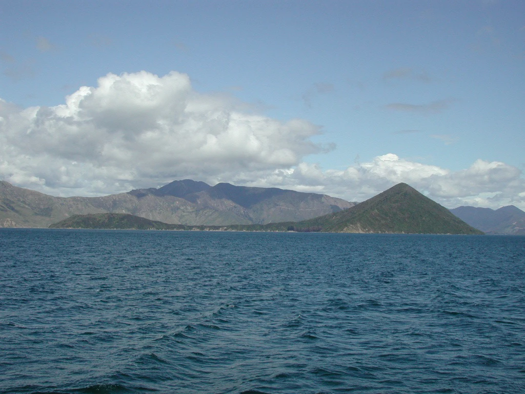
A wide angle view of a green, hilly island surrounded by deep blue water under a partly cloudy sky.
Maud Island seen from the waters of the Marlborough Sounds.

Maud Island (Te Hoiere) history and protected-area timeline

The earliest documented human presence on Maud Island was that of Māori, who established gardens and built food storage pits across the island and gave it the name Te Pākeka. After European settlement, ownership of the island was granted to John Gibson in 1867, beginning a period of private ownership that continued for more than a century.

During the Second World War the island took on a military role. Gun emplacements and range-finding equipment were installed, with the remains still visible from the present-day Gun Emplacement Track near the island's northernmost point. A jetty was built at the same time to support the maintenance of this military infrastructure.

The decisive shift toward a conservation future came in 1971, when then-owner Jack Shand gifted part of the island to the Crown. The remaining land soon became property of the Royal Forest and Bird Protection Society. These changes set the stage for the official designation of the island as a Scientific Reserve, with both the names Maud Island and Te Hoiere receiving official status in 1948, and the reserve now operating under the joint name Te Pākeka / Maud Island Scientific Reserve.

Maud Island (Te Hoiere) landscape and geographic character

Maud Island's landscape is shaped by the drowned-valley geography typical of the Marlborough Sounds. The island is enclosed by channels and reaches on almost every side, with Apuau Channel separating it from the mainland to the west, Waitātā Reach to the north and east, and Tawhitinui Reach to the south. This deeply indented setting gives the island a sheltered, almost fjord-like maritime character.

The terrain itself is steep and hilly. The larger western portion of the island runs broadly northeast to southwest and reaches a height of 368 metres, while the smaller eastern spur rises to about 113 metres. The two land masses are joined by a narrow isthmus about a kilometre long, with the southernmost point, Harter Point, lying on this spur.

Vegetation contributes strongly to the island's visual identity, covering the hills in a continuous cloak of native forest that extends down toward the coastline. A walking track, the Gun Emplacement Track, follows the contours of the western portion of the island and provides the main on-land route through the otherwise largely inaccessible landscape.

Maud Island (Te Hoiere) ecosystems, habitats, and plant life

As a long-protected and predator-free island, Maud Island supports forest and shoreline habitats that have been allowed to develop with relatively little disturbance from browsing mammals. Native broadleaf and conifer forest dominates the hill slopes, while flax and other coastal vegetation fringe parts of the shore. These habitats, combined with the island's isolation and security status, create a refuge-like ecological environment that is unusual in mainland New Zealand.

The island's ecosystems are largely valued as a setting for species recovery rather than as visible tourist landscapes. The forest provides nesting and feeding habitat for translocated native birds, damp microhabitats for native frogs, and refuges for native invertebrates that are otherwise declining on the mainland. In the broader ecological picture, Maud Island sits within the temperate, mild, and wet maritime climate zone of the Marlborough Sounds, with relatively warm summers and mild, wet winters.

Because public access is constrained, the habitats of Maud Island are treated as research environments as much as natural areas. Their ecological significance is measured largely in terms of the species they support and the predator-free conditions they maintain.

Maud Island (Te Hoiere) wildlife and species highlights

Maud Island is especially significant for bird conservation. It was one of the first offshore islands to which kākāpō, the critically endangered flightless parrot, were translocated. Conservationist Don Merton oversaw the introduction of kākāpō to the island in 1974, an early step in the national recovery programme that has since spread birds to other sanctuary islands such as Codfish Island / Whenua Hou, Anchor Island, and Little Barrier Island. Although the Maud Island kākāpō population was later moved to more heavily forested islands, the island's role as an early stepping stone remains central to the species' history. The island also received takahē in 1985, adding another rare native bird to its conservation role.

The island gives its name to the Maud Island frog, a small native frog originally distinguished from Hamilton's frog as a separate species, Leiopelma pakeka. Although more recent taxonomic work has merged the two populations back under Hamilton's frog, the Maud Island population still holds distinct conservation importance and is one of only a handful of native frog populations in New Zealand.

Invertebrate life on the island is also rich. Native wētā are abundant, including tree wētā, cave wētā, and the distinctive Cook Strait giant wētā, which can often be observed at night. The Cook Strait click beetle, a rare species, is also present, as is the large flax weevil, typically seen on flax plants. Together, these birds, frogs, and invertebrates give the island a profile of conservation importance that extends beyond any single flagship species.

Maud Island (Te Hoiere) conservation status and protection priorities

Maud Island's conservation importance rests on its status as one of New Zealand's earliest predator-free offshore sanctuaries. Classified as a Scientific Reserve under the Reserves Act and administered by the Department of Conservation, the island is closed to general public access and is managed primarily for research and species recovery. Visitation is allowed only by special permit, a restriction that has been essential to maintaining the island's predator-free condition and the integrity of its restoring ecosystems.

The island's role in the wider conservation system is significant. It has been used as a holding site and refuge for some of the country's rarest native birds, including kākāpō and takahē, and it shelters one of New Zealand's few remaining populations of native frogs. By keeping this combination of species in a secure environment, Maud Island contributes directly to national-level efforts to prevent the extinction of species that cannot survive alongside introduced predators on the mainland.

The combination of formal reserve status, restricted access, and long-term partnerships with conservation organisations such as the Royal Forest and Bird Protection Society has made the island an enduring benchmark for the offshore island sanctuary model that now underpins much of New Zealand's threatened-species recovery work.

Maud Island (Te Hoiere) cultural meaning and human context

Maud Island has a layered cultural identity that reflects both its Māori and European histories. In te reo Māori the island is known as Te Hoiere, a name that it shares with the wider Pelorus Sound / Te Hoiere. Its older Māori name, Te Pākeka, remains in formal use today as part of the official name of the Te Pākeka / Maud Island Scientific Reserve, keeping the Māori heritage of the island visible in contemporary administrative language.

The early Māori presence is reflected in archaeological traces of cultivated gardens and food storage pits, suggesting that the island was used as a productive seasonal or settlement site. After European settlement, the island passed into private hands, was used as a military outpost during the Second World War, and was eventually transferred to conservation ownership. This sequence of uses; Māori settlement, European farming, wartime occupation, and scientific reserve status; lends the island a distinctive human history within the otherwise predominantly natural character of the Marlborough Sounds.

Top sights and standout views in Maud Island (Te Hoiere)

Among the standout features of Maud Island is its position within the Marlborough Sounds as one of the larger islands of the Pelorus Sound / Te Hoiere system, with a distinctive two-part shape joined by a narrow isthmus. The island's terrain rises to nearly 370 metres in steep, forested hills that drop down to sheltered channels and reaches on all sides.

The island's most significant highlight is ecological rather than scenic. Its role as a predator-free Scientific Reserve gave it a foundational place in the recovery of the kākāpō and the takahē, and makes it a recognised home of the Maud Island frog and a range of rare invertebrates including the Cook Strait giant wētā and the Cook Strait click beetle. The military-era gun emplacements along the Gun Emplacement Track add a secondary, more human layer to an otherwise strongly conservation-focused island.

Best time to visit Maud Island (Te Hoiere)

Public access to Maud Island is restricted to permit holders, so most people will never choose a personal visit time. For those with permitted research or conservation roles, the mild maritime climate of the Marlborough Sounds means the island is workable year round, with warmer, drier summer months generally offering better conditions for fieldwork and the wetter winter months bringing heavier rainfall and cooler temperatures. The mild temperatures in both summer and winter reflect the sheltered, coastal location of the island within the sounds.
Monthly climate preview

Long term weather by month patterns across representative coordinates in New Zealand

Maud Island Climate Normals: Measured Annual Temperature and Precipitation Rhythm

Representative coordinate records show average temperature and precipitation variation across the twelve month cycle at Maud Island. Examining the complete monthly climate normals reveals detailed long term atmospheric rhythms and regional environmental baselines.
Annual mean13 °C
10 °C18 °C
Jan17°
Feb18°
Mar16°
Apr14°
May13°
Jun11°
Jul10°
Aug10°
Sep11°
Oct12°
Nov14°
Dec16°
Warmest month
February

17.6 °C

Coolest month
July

9.7 °C

Wettest month
June

3.4 mm/day

Driest month
February

2.1 mm/day

Park location guide

Geography guide, regional context, and park location map for Maud Island (Te Hoiere)

Maud Island (Te Hoiere) park geography, regions, and map view in New Zealand

Understand where Maud Island (Te Hoiere) sits in New Zealand through a broader geographic reading of the surrounding landscape, nearby location context, and its mapped position within the national park landscape.

How Maud Island (Te Hoiere) fits into New Zealand

New Zealand is an island nation in the southwestern Pacific Ocean comprising two main islands and numerous smaller islands. Located east of Australia across the Tasman Sea, it features varied topography with the Southern Alps running along the South Island and volcanic terrain on the North Island. The country was settled by Maori people between 1280 and 1350, followed by European exploration beginning in 1642, and became a Dominion in 1907 before gaining full independence in 1947.

Wider geography shaping Maud Island (Te Hoiere) in New Zealand

New Zealand lies in the southwestern Pacific Ocean, east of Australia across the Tasman Sea. The country consists of two main islands, the North Island and South Island, plus over 600 smaller islands. The North Island features volcanic plateaus and hills while the South Island is dominated by the Southern Alps mountain range. The country has a long coastline and is surrounded by the Pacific Ocean.

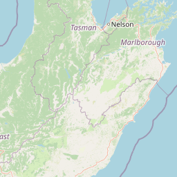
Map view of Maud Island (Te Hoiere)

Use this park location map to pinpoint Maud Island (Te Hoiere) in New Zealand, understand its exact geographic position, and read its mapped placement within the surrounding landscape more clearly.

Pigeon | © OpenStreetMap contributors

Explore protected habitats, native forest terrain, and coastal scenery across New Zealand.

Maud Island Photos and Landscapes, Visual Guide to the Marlborough Sounds Sanctuary

Visual documentation captures the steep forested terrain, narrow isthmus geography, and sheltered maritime channels defining Maud Island. Examining these protected area photographs reveals the ecological character and physical isolation of a restricted scientific reserve.

A wide angle view of a green, hilly island surrounded by deep blue water under a partly cloudy sky.

Park atlas

Compare nearby maritime reserves and protected landscapes across the Marlborough Sounds.

Other Parks Near Maud Island and Surrounding Regional Protected Areas

Browsing other parks near Maud Island reveals connected protected landscapes and sheltered coastal reserves throughout the Marlborough Sounds. Comparing these neighboring sanctuaries provides valuable regional context for New Zealand conservation geography.
Protected landscapeMarlborough Region
About 17 km away#1 closest

Southwest

Mount Richmond Forest Park: Geography and Protected Landscapes in the Marlborough Region

Expansive native bush and mountain peak terrain

Mount Richmond Forest Park stands as one of the largest protected forest areas on the South Island of New Zealand. Dominated by dense native bush and rugged subalpine ridges, the park offers a complex topography of river valleys and high-altitude peaks, including its namesake Mount Richmond. It serves as a vital conservation landscape and a core segment of the regional geography between Nelson and the Marlborough district.

Area
1,659 km²
Established
1977
Relief
Mountain
Scope
Terrestrial
Marine protected areaMarlborough Region
About 34 km away#2 closest

East

Long Island-Kokomohua Marine Reserve: Mapped Geography and Protected Reef Systems

Explore marine boundaries in the Marlborough Region

Located at the entrance to Queen Charlotte Sound, Long Island-Kokomohua Marine Reserve encompasses significant island and submerged reef features. This protected area serves as an essential site for understanding coastal ecosystem restoration, featuring varied terrain from shallow near-shore reefs to deeper rocky pinnacles that support diverse marine populations.

Area
6.19 km²
Established
1993
Relief
Lowland
Climate
Temperate
A horizontal watercolor illustration depicting rolling green hills, scattered trees, and soft, muted tones against a plain white background.
Nature reserveMarlborough Sounds
About 34 km away#3 closest

East

Motuara Island Nature Reserve: Protected Landscape and Geographic Discovery

Marlborough Sounds Coastal Reserve and Sanctuary

Motuara Island is a significant nature reserve characterized by its regenerating forest, rugged coastline, and elevated summit lookout. Serving as a sanctuary for native birds and a landmark of colonial and Māori history, this 59-hectare island remains a central point of geographic interest within the Marlborough Sounds ria system.

Area
0.59 km²
Established
1976
Relief
Upland
Climate
Temperate
Nature reserveMarlborough Region
About 42 km away#4 closest

North

Stephens Island (New Zealand) Nature Reserve: Geography and Protected Land Overview

Maritime sanctuary and ecological refuge in Marlborough Region

Stephens Island (New Zealand) acts as a rugged, compact island refuge in the Cook Strait, defined by steep terrain rising to 283 metres. As a critical nature reserve managed by Ngāti Koata and the Department of Conservation, this site offers profound insights into isolated island ecosystems, evolutionary endemic species, and the geological processes of the Maitai Group.

Area
1.5 km²
Established
1966
Relief
Upland
Climate
Temperate
National parkTasman District
About 69 km away#5 closest

West

Abel Tasman National Park: Coastal Protected Landscape and Mapped Geography in Tasman District

New Zealand's smallest national park offering iconic coastal hiking and wildlife.

Delve into the mapped boundaries and unique geography of Abel Tasman National Park, New Zealand's smallest national park located in the Tasman District. This protected landscape features renowned golden beaches, forested hills, and vital island ecosystems. Explore its coastal trails, understand its ecological restoration context, and appreciate its historical significance as a site of early European and Māori interaction, making it a key destination for atlas-driven geographic discovery.

Area
237.1 km²
Established
1942
IUCN
II
Relief
Upland
Nature reserveWellington
About 78 km away#6 closest

Southeast

Te Kopahou Reserve: Nature Reserve Geography and Coastal Landscapes in Wellington

A rugged intersection of forested hills, ridgelines, and coastal cliffs.

Situated on the southern edge of Wellington, Te Kopahou Reserve offers a diverse protected landscape ranging from the summit of Hawkins Hill to the iconic red rocks of the Cook Strait shoreline. This nature reserve provides a critical geographic transition, hosting regenerating native bush, exposed ridgeline trails, and vital habitats for local wildlife, making it a prominent example of regional conservation land on the North Island of New Zealand.

Area
6 km²
Relief
Mountain
Climate
Temperate
Access
Easy access
Protected landscapeWellington Region
About 80 km away#7 closest

East

Whitireia Park: Coastal Headland and Protected Landscape in the Wellington Region

Explore mapping of coastal terrain, forests, and harbour boundaries.

Whitireia Park is a prominent coastal reserve in the Wellington Region that balances deep Ngāti Toa cultural significance with a unique geological history shaped by centuries of earthquake uplift. The headland features open grasslands, remnant kohekohe forest, and ongoing wetland restoration that offers a layered view of New Zealand's natural and social history across its accessible harbour-edge geography.

Area
1.8 km²
Established
1976
Relief
Upland
Climate
Temperate
Watercolor painting of mountains, green valleys, and a winding river under a soft sky
National parkWest Coast Region
About 81 km away#8 closest

West

Kahurangi National Park: A National Park of Ancient Geology and Diverse Protected Landscapes in New Zealand

Explore the mapped natural terrain and regional geographic context.

Kahurangi National Park is distinguished by its extraordinary geological diversity, representing New Zealand's finest Paleozoic rock sequence and expansive karst features. Covering a vast area in the West Coast Region, it protects a remarkable array of natural landscapes, from coastal cliffs and nikau palm forests to alpine tussock basins and deep gorges. This national park is crucial for understanding New Zealand's natural heritage, offering a rich tapestry of mapped terrain and protected biodiversity for dedicated geographic exploration.

Area
5,193 km²
Established
1996
IUCN
II
Relief
Mixed relief

Common questions about visiting, size, designation, and location context for Maud Island (Te Hoiere)

Maud Island (Te Hoiere) FAQs for park facts, access, geography, and protected area context

Find quick answers about Maud Island (Te Hoiere), including protected-area facts, park geography, trail and visitor context, and how the park fits into its surrounding country and regional landscape.
MoriAtlas Explorer

Continue Your Protected Areas Search Across the Global Atlas

Deepen your exploration by continuing the structured search for national parks and protected areas worldwide. Utilize the comprehensive filtering capabilities to compare different conservation landscapes and refine your understanding of global park geography. Discover more about the distribution and characteristics of protected natural areas.

Global natural geography