Why Mouling National Park stands out
Mouling National Park is best known for its exceptional biodiversity and the dramatic ecological transition it encompasses within a relatively compact area. The park serves as a critical transition zone between tropical forest ecosystems at lower elevations and temperate forest communities at higher altitudes above 2,800 meters. This vertical ecological gradient, combined with the region's historical isolation from significant human development, has allowed remarkably diverse flora and fauna to persist. The park is particularly notable for housing populations of several threatened species including the takin, red panda, Bengal tiger, and Indian leopard, making it a significant conservation area within the Eastern Himalayan biodiversity hotspot.
Mouling National Park history and protected-area timeline
Mouling National Park was officially established on December 30, 1986, representing a significant milestone in Arunachal Pradesh's conservation history. The park became the second national park in the state, following the establishment of Namdapha National Park in 1972. This designation reflected growing recognition of the exceptional ecological values contained within the Dihang-Dibang region and the need to provide formal legal protection to its diverse ecosystems and wildlife populations.
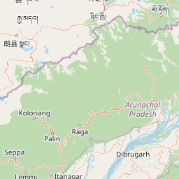
The creation of the park was part of broader efforts to establish a representative protected area network across India's Himalayan region. The park was incorporated as a core component of the Dihang-Dibang Biosphere Reserve, which was designated to preserve the ecological integrity of this unique mountain landscape while also allowing for sustainable use of natural resources in surrounding areas. The selection of the park boundaries was conducted through aerial surveys, utilizing natural features such as the Siyom River in the west and artificial demarcations where appropriate.
Despite its formal establishment, the park has faced ongoing challenges related to effective management and boundary demarcation. The complete on-ground delineation of boundaries remains incomplete, and the lack of road access has complicated regular patrol and monitoring activities. These infrastructure limitations, while presenting conservation challenges, have also inadvertently contributed to the park's relative ecological intactness by limiting commercial exploitation and development pressures.
Mouling National Park landscape and geographic character
Mouling National Park showcases a dramatic mountainous landscape characterized by steep ridges, deep valleys, and spectacular elevation changes. The terrain is fundamentally defined by its position within the Himalayan orogen, with the park's highest point at Mouling Peak reaching 3,064 meters above sea level while the lower boundaries descend to approximately 750 meters. This altitudinal span of nearly 2,300 meters creates a visually spectacular and ecologically diverse landscape.
The park's hydrological network is centered on the Siyom River, which flows along the western fringes of the protected area. Numerous smaller streams including the Siring, Krobong, Semong, and Subong rivers drain from the park's interior, eventually joining the Siang River system near the eastern boundary. This network of waterways has carved deep valleys through the mountainous terrain, creating diverse microhabitats and influencing vegetation patterns throughout the park.
The climate is characterized by extreme humidity and heavy precipitation, with annual rainfall averaging 2,343 millimeters. Unlike many Himalayan locations, the area lacks a well-defined dry season, maintaining moist conditions throughout the year. Temperature regimes vary significantly with elevation: at lower altitudes, temperatures range from 15 to 38 degrees Celsius, while at higher elevations above 2,200 meters, winter conditions bring temperatures down to approximately 4.2 degrees Celsius, with winter snowfall occurring at the highest elevations.
Mouling National Park ecosystems, habitats, and plant life
Mouling National Park occupies a critical position within the Eastern Himalayan biodiversity hotspot, supporting an extraordinary range of ecological communities within its boundaries. The park is often described as the state's cradle of biodiversity, a designation that reflects the remarkable concentration of species and habitats found within this relatively compact protected area. The diversity of life here is attributed to the juxtaposition of multiple distinct biotopes created by the dramatic elevational gradient.
The ecological character of the park is fundamentally defined by its role as a transition zone between two major forest types. At lower elevations below approximately 2,800 meters, tropical forest communities dominate, characterized by broadleaf evergreen species adapted to the warm, humid conditions. Above this threshold, the vegetation transitions to temperate forest assemblages dominated by species adapted to cooler conditions and seasonal temperature variations. This vertical zonation creates a complex mosaic of habitats that supports both tropical and temperate species within close geographic proximity.
The overall inaccessibility of the park has been a significant factor in maintaining its ecological integrity. Limited road access has restricted human encroachment and allowed relatively natural ecosystem processes to continue in the core areas. The combination of rugged terrain, heavy precipitation, and limited human disturbance has created conditions favorable for the persistence of diverse flora and fauna, many of which are of significant conservation concern.
Mouling National Park wildlife and species highlights
Mouling National Park supports an impressive array of mammalian species, several of which are of significant conservation importance. The takin, a large and distinctive goat-antelope found primarily in the Eastern Himalayas, inhabits the higher elevation grasslands and forest edges within the park. This unusual animal, which resembles a cross between a goat and a muskox, is considered near threatened and populations in protected areas like Mouling represent important reservoirs of genetic diversity.
The red panda, one of the most charismatic species associated with Himalayan biodiversity, is also present within the park boundaries. This arboreal mammal, though not closely related to the giant panda, occupies similar ecological niches in temperate forest habitats and feeds primarily on bamboo. Other notable mammals include the goral and serow, two goat-antelope species that occupy rocky terrain and forest margins, as well as the barking deer and various primate species.
Large predators are represented by both the Bengal tiger and Indian leopard, both of which maintain populations within the park's diverse habitats. The presence of these apex predators indicates the existence of complete ecological food webs and healthy prey populations. While specific population estimates are not well established due to the difficulty of conducting thorough surveys in such remote terrain, the confirmed presence of these species indicates significant conservation value. The region's reputation for harboring substantial snake populations, reflected in the park's name derivation, remains anecdotally reported though ecological documentation of reptile diversity in the park remains limited.
Mouling National Park conservation status and protection priorities
Mouling National Park represents a critical conservation priority within India's protected area network, serving as a core zone within the Dihang-Dibang Biosphere Reserve. The park's inclusion within this broader biosphere reserve designation reflects recognition of its exceptional ecological values and the need to maintain connectivity with surrounding landscapes that support ecological processes and traditional land uses. The biosphere reserve approach allows for the preservation of core protected areas like Mouling while permitting sustainable use and community involvement in buffer and transition zones.
The conservation significance of the park is enhanced by its role as an altitudinal gradient preserve, protecting the full spectrum of forest types from tropical to temperate within a single protected area. This comprehensive protection is increasingly important as climate change prompts species to shift their ranges along elevational gradients, making protected areas that encompass complete gradients particularly valuable for maintaining biodiversity under changing conditions.
Challenges to conservation include the incomplete boundary demarcation, which creates potential for encroachment and boundary disputes, and the limited management capacity due to difficult access. The lack of road infrastructure, while limiting human pressures, also constrains effective patrolling and monitoring. Conservation priorities for the park would ideally include completing boundary demarcation, developing infrastructure for effective management, and conducting systematic biodiversity surveys to better understand the park's ecological values and develop appropriate management strategies.
Mouling National Park cultural meaning and human context
Mouling National Park is situated within the traditional territory of the Adi people, an indigenous community who have inhabited the mountains of Arunachal Pradesh for generations. The park's name itself derives from the Adi language, specifically the word 'Mouling,' which translates to 'red poison' or 'red blood.' This nomenclature references the red latex produced by certain tree species found in the area and reflects the deep connections between indigenous knowledge systems and the local landscape.
Traditional land use practices, particularly jhum cultivation, have historically occurred within the park area, with evidence of such activities concentrated in the northern and southeastern portions of the protected zone. These traditional agricultural practices, involving rotation cultivation in forested areas, represent long-established relationships between local communities and the landscape. Understanding and integrating traditional ecological knowledge into park management remains important for effective conservation that respects indigenous rights and traditional practices.
The local communities maintain strong cultural connections to the forest resources that surround them, and any effective conservation approach must consider the livelihoods and traditions of these residents. The remote nature of the park has somewhat insulated traditional communities from rapid modernization, though changing economic conditions and development pressures are increasingly influencing local land use patterns and traditional practices.
Top sights and standout views in Mouling National Park
Mouling National Park offers visitors and researchers access to one of the Eastern Himalayas' most biodiverse and ecologically significant landscapes. The dramatic altitudinal range from 750 to 3,064 meters creates a spectacular setting where tropical and temperate ecosystems meet within a relatively compact area. The transition zone between these major forest types supports remarkable species diversity and represents a natural laboratory for understanding ecological processes along environmental gradients.
The presence of species such as the takin, red panda, Bengal tiger, and Indian leopard indicates the park's importance as a habitat for threatened wildlife and its role in maintaining viable populations of apex predators and herbivores. The relative ecological intactness of the park, despite being established in 1986, reflects both the effectiveness of protection measures and the challenges of accessing and developing this remote mountain landscape. The Dihang-Dibang Biosphere Reserve framework provides additional context for understanding the park's conservation significance within the broader regional landscape.
Best time to visit Mouling National Park
The climate of Mouling National Park is characterized by high humidity and consistent precipitation throughout the year, with no clearly defined dry season. Annual rainfall exceeds 2,300 millimeters, creating consistently moist conditions. For visitors, the most comfortable conditions typically occur during the cooler winter months from October through March, when temperatures at higher elevations are more moderate and the risk of leeches and other moisture-related challenges is reduced.
Winter conditions at higher elevations can be severe, with temperatures dropping to around 4 degrees Celsius and snowfall occurring above 2,200 meters. The monsoon season from approximately May through September brings the heaviest rainfall and creates challenging conditions for travel within the park. The transition periods of spring and autumn may offer moderate conditions, though heavy rainfall can occur in any season given the consistently humid conditions. Visitors should be prepared for the possibility of rain regardless of when they travel and should consider the challenges posed by the park's remoteness when planning any visit.