Mountain saddles
Snoqualmie Pass
919 m

Detailed analysis of regional boundaries, elevation data, and natural landscape features
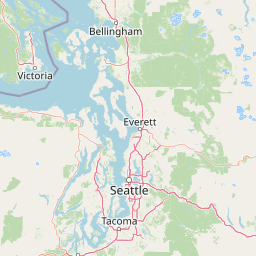
Examine the structural geography of Mount Baker–Snoqualmie National Forest within Washington, featuring an expansive 6978 square kilometer boundary. This profile details the mountain relief, alpine climate zones, and riverine networks that define the terrain. Review the elevation gradients and specific land formations contained across this significant protected landscape.
The most visited national forest in the United States, stretching along the western Cascades from Canada to Mount Rainier.
Mount Baker–Snoqualmie National Forest is one of the largest and most heavily used national forests in the United States. Spanning more than 140 miles along the western slopes of the Cascade Range in Washington State, it extends from the Canada–United States border south to the northern boundary of Mount Rainier National Park. The forest encompasses a striking transition of landscapes, from low-elevation maritime forests and river valleys in the west to rugged alpine ridges, volcanic peaks, and extensive glaciated terrain in the Cascades. Two prominent stratovolcanoes, Mount Baker and Glacier Peak, rise far above the surrounding ridges and give the forest much of its dramatic character. Its proximity to major population centers in the Puget Sound region and the Vancouver metropolitan area has made it a defining outdoor destination for the Pacific Northwest, supporting hiking, skiing, climbing, wildlife viewing, and an exceptional network of designated wilderness areas and wild rivers.
Country and regional administrative context across the United States
Interactive boundary geometry and derived spatial measurements
Mountain park relief, vertical range, and physical features
Mountain saddles
919 m
Mountain saddles
1,238 m
Mountain saddles
1,103 m
Mountain saddles
791 m
Mountain saddles
844 m
Mountain saddles
720 m
Interpreting alpine relief, forest cover, and glacial water systems
Mountains · Forest · Rivers · Glacier · Volcano
Temperate coniferous forest · Montane forest · Alpine meadow · Riverine habitat · Glacial habitat
Compare regional mountain terrain, glaciated volcanic peaks, and adjacent wilderness areas

Northeast

A detailed look at one of the most remote volcanic reserves in the Cascade Range.
Defined by the presence of an isolated stratovolcano and extensive glacial systems, Glacier Peak Wilderness represents a significant protected area within the Washington Cascades. This overview details the rugged landscape, from the deeply incised river valleys of the Chiwawa and Suiattle to the high-alpine rock and ice environment at the peak summit, providing essential geographic context for this roadless wilderness.
North
Exploration of a remote, roadless Cascade protected landscape
The Mount Baker National Recreation Area provides a unique geographic window into the volcanic heart of the Pacific Northwest. Characterized by its glacier-clad massif and network of subalpine trails, the area serves as a vital protected habitat for elk, mountain goats, and diverse conifer forests. This record details the park's topography, ranging from deep glacial valleys to high-elevation ridges that overlook the broader North Cascades region.

North
Protected wilderness boundaries in the Northern Cascades
Mount Baker Wilderness encompasses a vast mountain landscape characterized by an active stratovolcano and significant permanent snowfields. The terrain features a vertical gradient from dense west side conifer forests to exposed alpine summits, creating a distinct ecological corridor connected to neighboring protected areas in the Pacific Northwest.
South
Explore its protected landscape and regional geography.
Mount Rainier National Park represents a core protected area within Washington State, offering rich opportunities for geographic discovery through its mapped boundaries and natural terrain. As a designated national park, it contributes significantly to the atlas of United States protected lands. This destination allows for detailed exploration of its landscape context, making it an essential point of reference for understanding regional geography and conservation areas.
North
Explore mapped boundaries and regional Washington geography.
Gain insight into North Cascades National Park, a vital US National Park located in Washington. This entry focuses on its protected land status, mapped geographic extent, and its role within the regional atlas. Users seeking to understand the park's landscape character, natural terrain, and its specific location in Washington will find this an essential point for detailed park geography exploration and protected area discovery.

Northeast
Mapping ecological gradients and wilderness boundaries across the eastern Cascade Range
Spanning from the moist coniferous forests of the western Cascades to the arid plateaus of the Okanogan, this massive national forest protects an unmatched diversity of terrain. Explore the intricate geography of river-carved valleys, glacial cirques, and remote wilderness areas that characterize this critical environmental corridor in the Pacific Northwest.

North
Mapping the Skagit River and North Cascades alpine corridor
Located in the heart of Washington, Ross Lake National Recreation Area preserves a unique landscape of connected reservoirs and deep, glacier-cut valleys. This protected area acts as a vital geographic link within the North Cascades, offering access to high-altitude peaks, riverine forests, and the distinct turquoise waters of Diablo Lake.

South
Mapping volcanic peaks, deep river canyons, and old-growth wilderness corridors
Gifford Pinchot National Forest represents a major protected expanse in the Washington Cascades, characterized by a complex volcanic topography that includes active craters, cinder cones, and rugged lava fields. This atlas entry details the forest's primary geographic features, from the high-elevation alpine terrain of the Goat Rocks to the river-carved valleys of the Lewis and Cowlitz systems, providing essential context on this integral Pacific Northwest protected landscape.
Trace the boundaries and geologic features of this significant Washington protected area. Through the MoriAtlas database, analyze the distribution of wilderness, glacier-dense volcanic peaks, and river systems that define the character of the central and northern Cascade Range.