Mori Atlas logo
Protected areaMount Rose Wilderness

Understanding the ecological transition between Sierra Nevada peaks and Great Basin slopes

Mount Rose Wilderness: Protected Area Geography and Landscape Mapping in the Carson Range

(Mt. Rose Wilderness)

Mount Rose Wilderness occupies a distinct ecological boundary in the Carson Range of Nevada, bridging the gap between high-elevation alpine forests and the arid shrublands of the Great Basin. This protected area features dramatic changes in topography, ranging from 5,800 feet near the Reno basin to the 10,776-foot summit of Mount Rose. The landscape supports diverse vegetation patterns and preserves deep cultural roots, providing a clear map of the shifting environmental character found at the intersection of two major western North American regions.

Sierra NevadaCarson RangeGreat Basin transitionalpine wildernesssubalpine forestssagebrush country

Mount Rose Wilderness

Protected area

Park overview

Structured park overview, official facts, and landscape profile for Mount Rose Wilderness

Mount Rose Wilderness park facts, protected area profile, and essential visitor context

Review the core facts for Mount Rose Wilderness, including designation, size, terrain, visitor scale, habitats, and operating context in one park-focused overview.

About Mount Rose Wilderness

Mt. Rose Wilderness is a federally designated wilderness in the Carson Range of Nevada, positioned along the eastern edge of the Sierra Nevada where it overlooks both Lake Tahoe and the Reno metropolitan area. Despite its proximity to a sizable city and a major alpine lake, the wilderness preserves a substantial block of high-country terrain, including forested ridges, rocky summits, alpine meadows, and transitional vegetation patterns that reflect the mergence between two large-scale ecological systems.

The Carson Range itself is a smaller, often overlooked sub-range of the Sierra Nevada, and the Mt. Rose Wilderness captures some of its most prominent topography. Mount Rose, which gives the wilderness its name, is one of the most recognizable peaks in the region and serves as both a visual landmark and a popular hiking destination. The greater Reno-Tahoe area has long attracted outdoor recreation, and the wilderness plays an important role in preserving accessible yet rugged terrain for that use.

Ecologically, the wilderness is defined by its position between two worlds. The western and higher portions share much in common with the rest of the Sierra Nevada, with montane conifer forests, rock-strewn slopes, and high-elevation habitats. As one moves east and downward, the influence of the Great Basin becomes stronger, with drier conditions and vegetation more typical of Nevada's interior. This blending of bioregions is what gives the wilderness its particular botanical and ecological interest.

Beyond its natural features, the Mt. Rose Wilderness carries substantial cultural weight. The Washoe Tribe has deep, multigenerational connections to the area, and their continued presence is part of the region's identity. The wilderness designation in 1989 acknowledged both the need to protect this ecologically sensitive area and the value of preserving a landscape with such an extensive human history.

Quick facts and research context for Mount Rose Wilderness

Mt. Rose Wilderness is an IUCN Category Ib wilderness area located in Washoe County, Nevada, and managed by the U.S. Forest Service within the Humboldt-Toiyabe National Forest. Covering approximately 31,223 acres, it occupies a key position between Lake Tahoe to the west and Reno to the east. The wilderness was designated in 1989 and includes Mount Rose, one of the highest peaks in the immediate Reno-Tahoe region.

The area's elevations range from roughly 5,800 feet on its lower western edges to 10,776 feet at the summit of Mount Rose, making it one of the most accessible high-country wilderness areas adjacent to a major western U.S. city.

Protection and recognition

Documented terrestrial protection scope, management framework, and official designation metrics

Mount Rose Wilderness Protection Status and International Recognition Data

Mount Rose Wilderness maintains a documented terrestrial protection scope without imported international recognition sources or transboundary status. Official records catalog the baseline designation framework and management parameters for rigorous geographic analysis.

Protection details

Protection scope
Terrestrial
Transboundary protection
No
Park context

Deeper park guide and search-rich context for Mount Rose Wilderness

Mount Rose Wilderness history, landscape, wildlife, and travel context

Explore Mount Rose Wilderness through its history, landscape character, ecosystems, wildlife, conservation priorities, cultural context, and seasonal travel timing in a structured park guide built for atlas discovery and search intent.

Why Mount Rose Wilderness stands out

Mt. Rose Wilderness is best known for its dramatic ecological transition zone between the Sierra Nevada and the Great Basin. The Carson Range portion of the Sierra Nevada forms high, forested ridges and peaks, while the eastern side of the wilderness gradually opens into more arid, basin-influenced landscapes. This blend of forest and sage country in a single protected area is one of the wilderness's defining ecological features. The area is also recognized for being culturally significant to the Washoe Tribe, whose presence in the landscape spans more than 400 generations. Mount Rose itself, at over 10,700 feet, anchors the wilderness as both a scenic landmark and a focal point for backcountry recreation.

Mount Rose Wilderness history and protected-area timeline

The Mt. Rose Wilderness was formally designated as a protected wilderness area in 1989, placing the Carson Range slopes above Reno and Lake Tahoe under long-term federal preservation. The land itself, however, has a far older human story. The Washoe Tribe has inhabited the lands now encompassed by the wilderness for more than 400 generations, making it a landscape of profound cultural significance long before any modern designation.

The area's modern conservation history is tied to the Humboldt-Toiyabe National Forest, which continues to administer the wilderness under the U.S. Forest Service. The 1989 designation reflected growing recognition of the area's ecological value, particularly its role as a transition between Sierra Nevada and Great Basin environments, as well as its proximity to two of Nevada's most important population and tourism centers.

Mount Rose Wilderness landscape and geographic character

The Mt. Rose Wilderness occupies the eastern flank of the Carson Range, a sub-range of the Sierra Nevada that rises sharply above the Reno basin and the northwestern shore of Lake Tahoe. The terrain includes forested ridges, glacially carved valleys, exposed rocky slopes, and high meadows, with elevations spanning roughly 5,800 feet on the lower western edges near Reno to 10,776 feet at the top of Mount Rose.

At higher elevations, the landscape takes on a distinctly alpine character, with open granite ridges, subalpine forests, and views that extend across Lake Tahoe and into the broader Sierra Nevada. Lower down, and especially toward the east, the topography softens into more typical Great Basin landscapes, with rolling terrain and drier vegetation that contrasts with the wetter mountain slopes above. This visual and ecological gradient, from lake-and-forest to basin-edge terrain, is one of the defining physical features of the wilderness.

Mount Rose Wilderness ecosystems, habitats, and plant life

Because the Mt. Rose Wilderness sits between the Sierra Nevada and the Great Basin, it functions as a living meeting place between two distinct ecological regions. On the higher, wetter, west- and north-facing slopes, vegetation patterns resemble those of the broader Sierra Nevada, with conifer forests that include species typical of mid- and high-elevation Sierra habitats. These forested zones are interspersed with riparian corridors along streams and drainages that descend toward Lake Tahoe and the Truckee Meadows.

As elevation decreases and the climate becomes drier toward the east, plant communities shift toward species more characteristic of the Great Basin. Sagebrush and other drought-adapted shrubs become more prominent, and the understory transitions accordingly. This overlap between Sierra Nevada forest types and Great Basin shrub communities in a single protected area gives the wilderness a notably diverse botanical character.

The varied topography, ranging from dense forest and riparian habitat up to exposed alpine ridges, supports a corresponding range of habitat conditions across the wilderness, which in turn influences the wildlife found there.

Mount Rose Wilderness conservation status and protection priorities

The Mt. Rose Wilderness was designated under the U.S. National Wilderness Preservation System and is managed by the Humboldt-Toiyabe National Forest, making it part of the country's broader framework for protecting wild landscapes. Its conservation significance rests heavily on its ecological position: by protecting a substantial block of land where Sierra Nevada and Great Basin vegetation overlap, the wilderness safeguards a transitional landscape that would otherwise be increasingly difficult to preserve given its proximity to Reno and Lake Tahoe.

The wilderness also contributes to conserving high-elevation habitat in the Carson Range, including forested slopes, riparian corridors, and alpine environments that are sensitive to disturbance. Maintaining the area's protected status helps limit fragmentation, preserve water sources for downstream communities, and protect Sierra headwater environments that influence Lake Tahoe's clarity.

Mount Rose Wilderness cultural meaning and human context

The Mt. Rose Wilderness carries a long and meaningful human history tied to the Washoe Tribe, whose presence in the region has spanned more than 400 generations. The Washoe have longstanding cultural, spiritual, and practical ties to the mountains, meadows, and waterways of the Carson Range, and the wilderness area overlaps with lands that have historically been part of their homeland.

This deep indigenous heritage is an important part of how the area is understood, even as the modern wilderness designation brings visitors for hiking, skiing, and scenic enjoyment. The recognition of Native presence in the landscape is increasingly considered integral to the story of the Carson Range and the broader Tahoe-Reno region.

Top sights and standout views in Mount Rose Wilderness

Among the standout features of the Mt. Rose Wilderness are Mount Rose itself, at 10,776 feet, and the spectacular views it offers across Lake Tahoe and into the Sierra Nevada. The wilderness's ecological transition between forested Sierra habitat and drier Great Basin environments is another defining highlight, allowing visitors to experience a clear shift in vegetation patterns within a relatively compact area.

The wilderness's accessibility from both Reno and Lake Tahoe, combined with its preserved, lightly developed backcountry, also makes it notable as one of the most easily reached high-country wildernesses in Nevada. The presence of streams, forested slopes, alpine meadows, and panoramic overlooks gives the area a wide range of scenery within its roughly 31,000 acres.

Best time to visit Mount Rose Wilderness

The Mt. Rose Wilderness changes dramatically with the seasons, making timing an important part of the experience. Summer is the most accessible period for hiking and exploring the higher elevations, with snow-free trails, blooming meadows at mid-elevations, and long daylight hours that make longer routes more practical.

Fall brings cooler temperatures, reduced crowds, and the changing colors of aspen and other high-elevation vegetation, often paired with clear views toward Lake Tahoe. Winter transforms much of the wilderness into a snowy landscape, and the Mount Rose area near the highway is renowned for its access to winter recreation; however, deep snow limits backcountry travel to experienced users. Spring is a transitional season, with snow lingering at higher elevations while lower trails and wildflower displays begin to emerge.

Monthly climate preview

Measured monthly averages and precipitation patterns for Nevada protected terrain

Mount Rose Wilderness Climate Normals and Long Term Temperature Rhythms

Representative coordinates track long term temperature variations and precipitation distribution across the protected landscape throughout the year. Reviewing the complete monthly profile provides deeper analytical depth regarding regional climate norms and seasonal weather shifts.
Annual mean9 °C
-1 °C21 °C
Jan-1°
Feb
Mar
Apr
May11°
Jun16°
Jul21°
Aug20°
Sep16°
Oct
Nov
Dec-1°
Warmest month
July

21 °C

Coolest month
December

-1.4 °C

Wettest month
February

3.3 mm/day

Driest month
August

0.2 mm/day

Park location guide

Geography guide, regional context, and park location map for Mount Rose Wilderness

Mount Rose Wilderness park geography, regions, and map view in United States of America

Understand where Mount Rose Wilderness sits in United States of America through a broader geographic reading of the surrounding landscape, nearby location context, and its mapped position within the national park landscape.

How Mount Rose Wilderness fits into United States of America

The United States of America is a federal presidential republic and one of the world's largest countries by area and population. It consists of 50 states across a vast territory spanning multiple time zones, with its capital in Washington, D.C. and largest city in New York City. The nation has a diverse economy, influential political system, and significant cultural and military presence globally.

Wider geography shaping Mount Rose Wilderness in United States of America

The United States occupies a vast territory in North America, bordered by Canada to the north and Mexico to the south. The 48 contiguous states stretch from the Atlantic to the Pacific Ocean, while Alaska occupies the northwestern region and Hawaii is an archipelago in the Pacific. The country encompasses diverse terrain including the Rocky Mountains, Appalachian Mountains, Great Plains, and extensive river systems.

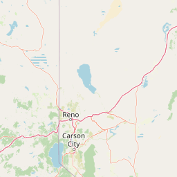
Map view of Mount Rose Wilderness

Use this park location map to pinpoint Mount Rose Wilderness in United States of America, understand its exact geographic position, and read its mapped placement within the surrounding landscape more clearly.

Pigeon | © OpenStreetMap contributors

Location context for Mount Rose Wilderness

Nevada
Park atlas

Compare regional alpine geography, mountain ranges, and connected conservation landscapes.

Explore Other Parks Near Mount Rose Wilderness And Surrounding Protected Areas

Visitors exploring Mount Rose Wilderness can continue browsing nearby national parks and protected areas across the Carson Range and surrounding regional terrain. Analyzing adjacent mountain landscapes reveals broader ecological gradients spanning from Sierra Nevada forests into the Great Basin.
A watercolor painting showing soft green hills, distant pink-hued mountains, and a pale blue lake in a serene, stylized landscape.
Protected landscapeNevada
Mapped location lies within the park boundary#1 closest

East

Humboldt, Toiyabe National Forest: Protected Landscape and Regional Mountain Geography

A vast network of Nevada mountain ranges and alpine wilderness

Humboldt, Toiyabe National Forest serves as a defining public land entity across Nevada and eastern California. As the largest national forest in the contiguous United States, it preserves a striking collection of isolated mountain ranges, including the Ruby Mountains and the rugged Jarbidge wilderness, within a broader basin-and-range landscape. Examine the boundaries and terrain that characterize this complex, high-desert ecosystem.

Area
25,454 km²
Established
1908
Relief
Mountain
Access
Easy access
Protected landscapeCalifornia
About 10 km away#2 closest

Northwest

Tahoe National Forest: Exploring Protected Mountain Landscapes in the California Sierra Nevada

An atlas of granite river canyons and alpine ridge terrain

Tahoe National Forest defines a critical segment of the western Sierra Nevada, containing granite river canyons, numerous reservoirs, and summits reaching above 9,000 feet. This protected landscape acts as a vital headwater for California foothill communities and Nevada, hosting significant natural features like the Placer County Big Trees Grove and segments of the Pacific Crest Trail.

Area
3,526.82 km²
Established
1899
Relief
Mountain
Climate
Mediterranean
Protected landscapeCalifornia
About 55 km away#3 closest

Northwest

Plumas National Forest: Mapped Geography and Protected Landscape Features in California

Exploring the Sierra Nevada watershed and wilderness terrain

Plumas National Forest serves as a critical protected landscape in northern California, anchoring the headwaters of the Feather River system. This atlas entry details the forest's rugged canyons, high elevation mountain lakes, and significant old growth conifer stands that define its role within the northern Sierra Nevada ecosystem.

Area
4,640 km²
Established
1907
Relief
Mountain
Climate
Mediterranean
Watercolor painting of green rolling hills, a tree-lined foreground, and a soft pink sunset sky.
Protected landscapeCalifornia
About 86 km away#4 closest

South

Stanislaus National Forest: Sierra Nevada Mountain Geography and Protected Wilderness Lands

California mountain terrain and forest landscape map

Stanislaus National Forest is a sprawling protected landscape located in the central Sierra Nevada of California. Characterized by volcanic and granite formations, the area protects critical watersheds, Wild and Scenic rivers, and large swaths of old growth forest that define the rugged mountain interior.

Area
3,634.48 km²
Established
1897
Relief
Mountain
Climate
Temperate
Watercolor painting of a tranquil mountain lake surrounded by pine forests and distant rolling peaks in muted green and pink tones.
Wildlife reserveTuolumne County
About 116 km away#5 closest

South

Emigrant Wilderness: A Detailed Geographic Atlas of Protected Sierra Nevada Landscapes

Mapping glaciated granite basins and volcanic ridges in Tuolumne County.

Emigrant Wilderness is a sprawling protected area defined by a distinct mix of granitic domes, cirques, and a unique volcanic sector in its northeastern reaches. Spanning from lower forest elevations to alpine peaks, the area provides a window into the complex geological history of the central Sierra Nevada. The terrain includes hundreds of high-country lakes and meadow systems that support diverse alpine ecosystems and represent the rugged nature of the Pacific Crest Trail corridor.

Area
454.37 km²
Established
1974
IUCN
Ib
Relief
Mountain
A wide watercolor illustration showing a calm body of water surrounded by green hills, conifer trees, and reeds in the foreground.
Protected landscapeCalifornia
About 118 km away#6 closest

Northwest

Lassen National Forest: Mapped Geography and Protected Landscapes of Northern California

Volcanic terrain and expansive old growth ecosystems

Lassen National Forest represents a vast protected landscape in Northern California, defined by its severe volcanic geology and resilient conifer forests. This atlas entry provides essential geographic context regarding the forest boundaries, the volcanic rim of Mount Tehama, and the intricate river systems shaping the region. Explore the terrain, from accessible lava tubes to the wilderness areas preserved within this significant mountain corridor.

Area
4,331.53 km²
Established
1905
Relief
Mountain
Climate
Temperate
Wildlife reserveCalifornia
About 118 km away#7 closest

South

Hoover Wilderness: Protected Alpine Geography in the Central Sierra Nevada, California

High-altitude glacial basins and Sierra crest wilderness

The Hoover Wilderness preserves a vital strip of high-elevation terrain along the eastern Sierra Nevada crest. Characterized by glacier-carved basins, interconnected alpine lakes, and sharp granite ridges, this protected area serves as a primary ecological gateway to the high country. Its landscape features define the headwaters of the Walker River, offering a compact yet significant look at California's protected alpine wilderness.

Area
518.89 km²
Established
1964
IUCN
Ib
Relief
Mountain
Watercolor painting showing mountains, a winding river, and green forests in the foreground and background
National parkCalifornia
About 132 km away#8 closest

South

Yosemite National Park: Protected Landscape Identity and Geographic Atlas Context

Mapped boundaries and regional setting for a key California national park.

Delve into the protected landscape identity of Yosemite National Park, examining its specific geographic features and its place within the broader atlas of California's natural areas. This entry provides detailed context on its mapped boundaries, regional positioning, and significance as a protected natural site, essential for understanding its landscape and conservation geography.

Area
3,070 km²
Established
1890
IUCN
II
Visitors
3.9M annual

Common questions about visiting, size, designation, and location context for Mount Rose Wilderness

Mount Rose Wilderness FAQs for park facts, access, geography, and protected area context

Find quick answers about Mount Rose Wilderness, including protected-area facts, park geography, trail and visitor context, and how the park fits into its surrounding country and regional landscape.
MoriAtlas Explorer

Continue Your Protected Areas Search Across the Global Atlas

Deepen your exploration by continuing the structured search for national parks and protected areas worldwide. Utilize the comprehensive filtering capabilities to compare different conservation landscapes and refine your understanding of global park geography. Discover more about the distribution and characteristics of protected natural areas.

Global natural geography